History
On first sighting a European ship off the coast, the Giray took it for a monster from the deep called Koorung in their traditional law, and fled the area. European settlement of the area began in 1838 and in the early 1840s the Girai wurrung engaged in a sustained guerilla war with the encroaching pastoralists. Dispossession from their land led to starvation and the theft of sheep resulted in murderous reprisals. In early 1839, Frederick Taylor, the manager at George McKillop and James Smith's station at Glenormiston, on being informed that around 50 members of the Jarcoort clan were camped in a gully at Mount Emu creek (the site was known as Tampirr), not far from Camperdown. Taylor rounded up a squatter vigilante band and virtually wiped out the whole group, men, women and children. Ian D. Clark states the estimated deaths at 35–40. A few survived, one woman called Bareetch Chuumeen, managed to swim to safety across Lake Bullen with her child on her shoulders. The place thereafter was called 'Murdering Gully.' places this within Djargurd wurrung country.
Assistant Aboriginal Protector Charles Sievwright was successful in bringing charges against G.S. Bolden for killing 2 Gunawurd gundidj people on 27 October 1841, but Supreme Court Judge Willis acquitted Bolden in December 1841 of the charges and spoke of the right of squatter licencees to turn anyone off their property. This decision was made despite the conditional nature of the squatter's licence by the Government to allow for Aboriginal access for hunting and traditional use.
During 1841 Assistant Protector CW Sievwright set up headquarters at two locations: Lake Keilambete and Lake Terang, but these were only temporary and Sievwright was ordered by Robinson to move to Mount Rouse in February 1842.
When Framlingham Aboriginal Reserve was occupied in 1865 near Warrnambool many of the surviving members of the Girai wurrung joined the reserve along with surviving Djargurd wurrung who were forcibly relocated and Gunditjmara from Warrnambool. Gunditjmara from Portland and Lake Condah refused to settle at Framlingham, leading to the establishment of Lake Condah reserve in 1869.
The historian Ian Clark asserts that from 1868 the history of the Girai wurrung becomes the history of Framlingham.
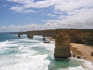
The Western District comprises western regions of the Australian state of Victoria. It is said to be an ill–defined district, sometimes incorrectly referred to as an economic region,. The district is located within parts of the Barwon South West and the Grampians regions; extending from the south-west corner of the state to Ballarat in the east and as far north as Ararat. The district is bounded by the Wimmera district in the north, by the Goldfields district in the east, by Bass Strait and the Southern Ocean in the south, and by the South Australian border in the west. The district is well known for the production of wool. The most populated city in the Western District is the Ballarat region, with 96,940 inhabitants.
The Wadawurrung nation, also called the Wathaurong, Wathaurung, and Wadda Wurrung, are an Aboriginal Australian people living in the area near Melbourne, Geelong and the Bellarine Peninsula in the state of Victoria. They are part of the Kulin alliance. The Wathaurong language was spoken by 25 clans south of the Werribee River and the Bellarine Peninsula to Streatham. The area they inhabit has been occupied for at least the last 25,000 years.

Lake Bolac is a town in the Western District region of Victoria, Australia. The town is on the shores of Lake Bolac, and the Glenelg Highway passes through the town. At the 2021 census, Lake Bolac and the surrounding area had a population of 368.
Framlingham is a rural township located by the Hopkins River in the Western District of Victoria, Australia, about 20 kilometres (12 mi) north-east of the coastal city of Warrnambool. In the 2016 census, the township had a population of 158.
The Gunditjmara or Gunditjamara, also known as Dhauwurd Wurrung, are an Aboriginal Australian people of southwestern Victoria. They are the traditional owners of the areas now encompassing Warrnambool, Port Fairy, Woolsthorpe and Portland. Their land includes much of the Budj Bim heritage areas. The Kerrup Jmara are a clan of the Gunditjmara, whose traditional lands are around Lake Condah. The Koroitgundidj are another clan group, whose lands are around Tower Hill.

Mount Elephant is a 380-metre-high (1,250 ft) conical breached scoria cone formed by a dormant volcano, located 1 km from the town of Derrinallum in southwestern Victoria, Australia. It is a prominent landmark that forms the eastern gateway to the Kanawinka Geopark from the Hamilton Highway at Derrinallum.
Dja Dja Wurrung, also known as the Djaara or Jajowrong people and Loddon River tribe, are an Aboriginal Australian people who are the traditional owners of lands including the watersheds of the Loddon and Avoca rivers in the Bendigo region of central Victoria, Australia. They are part of the Kulin alliance of Aboriginal Victorian peoples. There are 16 clans, which adhere to a patrilineal system. Like other Kulin peoples, there are two moieties: Bunjil the eagle and Waa the crow.
The Jardwadjali (Yartwatjali), also known as the Jaadwa, are an Aboriginal Australian people of the state of Victoria, whose traditional lands occupy the lands in the upper Wimmera River watershed east to Gariwerd (Grampians) and west to Lake Bringalbert.
The Djab Wurrung, also spelt Djabwurrung, Tjapwurrung, Tjap Wurrung, or Djapwarrung, people are Aboriginal Australians whose country is the volcanic plains of central Victoria from the Mount William Range of Gariwerd in the west to the Pyrenees range in the east encompassing the Wimmera River flowing north and the headwaters of the Hopkins River flowing south. The towns of Ararat, Stawell and Hamilton are within their territory. There were 41 Djab Wurrung clans who formed an alliance with the neighbouring Jardwadjali people through intermarriage, shared culture, trade and moiety system before colonisation. Their lands were conquered but never ceded.
The Djargurd Wurrong are Aboriginal Australian people of the Western district of the State of Victoria, and traditionally occupied the territory between Mount Emu Creek and Lake Corangamite.
Murdering Gully, formerly known as Puuroyup to the Djargurd Wurrung people, is the site of an 1839 massacre of 35–40 people of the Tarnbeere Gundidj clan of the Djargurd Wurrung in the Camperdown district of Victoria, Australia. It is a gully on Mount Emu Creek, where a small stream adjoins from Merida Station.

The Gadubanud (Katubanut), also known as the Pallidurgbarran, Yarro waetch or Cape Otway tribe (Tindale), are an Aboriginal Australian people of the state of Victoria. Their territory encompasses the rainforest plateau and rugged coastline of Cape Otway. They were thought to have become extinct quickly following the onset of European colonisation, and little is known of them. However, some may have found refuge at the Wesleyan mission station at Birregurra, and later the Framlingham mission station, and some people still trace their descent from such a remnant.
The Gulidjan people, also known as the Kolakngat, or Colac tribe, are an Aboriginal Australian tribe whose traditional lands cover the Lake Colac region of the state of Victoria, Australia. They occupied the grasslands, woodlands, volcanic plains and lakes region east of Lake Corangamite, west of the Barwon River and north of the Otway Ranges. Their territory bordered the Wathaurong to the north, Djargurd Wurrung to the west, Girai Wurrung to the south-west, and Gadubanud to the south-east.
Dhauwurd Wurrung is a term used for a group of languages spoken by various groups of the Gunditjmara people of the Western District of Victoria, Australia. Keerray Woorroong is regarded by some as a separate language, by others as a dialect. The dialect continuum consisted of various lects such as Kuurn Kopan Noot, Big Wurrung, Gai Wurrung, and others. There was no traditional name for the entire dialect continuum and it has been classified and labelled differently by different linguists and researchers. The group of languages is also referred to as Gunditjmara language and the Warrnambool language.
Aboriginal Victorians, the Aboriginal Australians of Victoria, Australia, occupied the land for tens of thousands of years prior to European settlement. Aboriginal people have lived a semi-nomadic existence of fishing, hunting and gathering, and farming eels in Victoria for at least 40,000 years.
The Bungandidj people are an Aboriginal Australian people from the Mount Gambier region in south-eastern South Australia, and also in western Victoria. Their language is the Bungandidj language. Bungandidj was historically frequently rendered as Boandik, Buandig, or Booandik.
The Eumeralla Wars were the violent encounters over the possession of land between British colonists and Gunditjmara Aboriginal people in what is now called the Western District area of south west Victoria.
Lake Condah Mission, also known as Condah Mission, was established in 1867 as a Church of England mission, approximately 3 kilometres (1.9 mi) from Lake Condah, which was traditionally known as Tae Rak, and about 20 kilometres (12 mi) to 25 kilometres (16 mi) south-east of the small town of Condah. The site of the mission, on 2,000 acres (810 ha) north of Darlot Creek, was formally reserved in 1869, and the Mission continued operations until the reserve was finally revoked in 1951, with most of the land handed over to the Soldiers Settlement Scheme to provide land for white veterans of World War II.
Albert Pompey Austin (1846?–1889), also known as Pompey Austin and Poorne Yarriworri, was an Australian footballer, cricketer and athlete. The first Indigenous person to play senior Australian Rules football in Victoria when he played for Geelong Football Club in 1872. He was a Djab Wurrung man.
The Eastern Maar people are a group of Aboriginal Australian peoples whose traditional lands are in the south-western part of state of Victoria, Australia. It is a name adopted by a number of Aboriginal Victorian groups who identify as Maar, including Eastern Gunditjmara, Tjap Wurrung, Peek Whurrong, Kirrae Whurrung, Kuurn Kopan Noot and/or Yarro waetch people.The word "Maar" means "the people".
