Gold Line (MARTA)

Last updated
Gold Line
Metropolitan Atlanta Rapid Transit Authority (logo).svg
MARTA CQ312 Gold Train.jpg
A Gold Line train on the viaduct north of Arts Center station
Overview
StatusOperational
Locale Atlanta, Georgia
Termini
Stations18 (4 Northeast, 6 North, Five Points, 7 South)
Service
Type Rapid transit
System MARTA rail
Operator(s) MARTA
Rolling stockSee MARTA rail#Rolling stock
History
Opened1981
Technical
Characterat grade, elevated, underground
Track gauge 4 ft 8+12 in (1,435 mm) standard gauge
Electrification Third rail,  750 V DC
Gold and Red Lines
BSicon numN345.svg
  Red  
BSicon uKBHFa.svg
N11
North Springs
BSicon PARKING.svg
BSicon uBHF.svg
N10
Sandy Springs
BSicon PARKING.svg
BSicon uTUNNEL1.svg
BSicon uBHF.svg
N9
Dunwoody
BSicon PARKING.svg
BSicon uSKRZ-G4o.svg
BSicon uBHF.svg
N8
Medical Center
BSicon PARKING.svg
BSicon uTUNNEL1.svg
BSicon uBHF.svg
N7
Buckhead
  Gold  
BSicon uSTR.svg
BSicon uKBHFa.svg
NE10
Doraville
BSicon PARKING.svg
BSicon uTUNNEL1.svg
BSicon uBHF.svg
NE9
Chamblee
BSicon PARKING.svg
BSicon uSTR.svg
BSicon uBHF.svg
NE8
Brookhaven/​Oglethorpe
BSicon PARKING.svg
BSicon uSTR.svg
BSicon uBHF.svg
NE7
Lenox
BSicon PARKING.svg
BSicon uSKRZ-G4o.svg
BSicon tRP4q.svg
BSicon uSKRZ-G4o.svg
BSicon uKRWl.svg
BSicon uKRW+lr.svg
BSicon uKRWr.svg
BSicon uTUNNEL1.svg
BSicon uBHF.svg
N6
Lindbergh Center
BSicon PARKING.svg
BSicon uABZgl+l.svg
BSicon uKDSTeq.svg
BSicon uSKRZ-G4o.svg
BSicon utBHFa@g.svg
N5
Arts Center
BSicon utBHF.svg
N4
Midtown
BSicon utBHF.svg
N3
North Avenue
BSicon utBHF.svg
N2
Civic Center
BSicon utINT.svg
N1
Peachtree Center BSicon TRAM.svg
BSicon utCONTgq.svg
BSicon utTINTt.svg
BSicon utCONTfq.svg
0
Five Points
BSicon utBHFe@g.svg
S1
Garnett
BSicon uSKRZ-G4o.svg
BSicon uBHF.svg
S2
West End
BSicon PARKING.svg
BSicon uBHF.svg
S3
Oakland City
BSicon PARKING.svg
BSicon uBHF.svg
S4
Lakewood/​Fort McPherson
BSicon PARKING.svg
BSicon uBHF.svg
S5
East Point
BSicon PARKING.svg
BSicon uTUNNEL1.svg
BSicon uBHF.svg
S6
College Park
BSicon PARKING.svg
BSicon uKDSTaq.svg
BSicon uABZgr+r.svg
South Yard & Shops
BSicon uSKRZ-G4o.svg
Red
Gold
BSicon uKINTe.svg
S7
Airport Gnome-searchtool.svg BSicon FLUG.svg
BSicon PARKING.svg

The Gold Line is a rapid transit line in the MARTA rail system. It operates between Doraville and Airport stations, running through Doraville, Chamblee, Brookhaven, Atlanta, East Point and College Park.

Contents

The Gold Line was previously called the Northeast-South Line until MARTA switched to a color-based naming system in October 2009. The North-South Line, from its launch, was considered one line, denoted with an orange color on old system maps until 2006 when the North Branch and the Northeast branch were redesignated as the North-South Line (the current Red Line) and the Northeast-South Line (the current Gold Line). Technically, with the 2009 designation change, there is no longer a mention of the color orange for the line. Using the Five Points station as a reference point, the Northeast Line was designated for trips headed to Doraville, and the South Line was designated for trips headed to the Airport.

The rail line was part of the initial MARTA north–south rail service in 1981. The first segment ran from the Garnett to the North Avenue stations, although the Peachtree Center opened the year after as an infill. In 1982, it expanded north to Arts Center, and in 1984, expanded as far north as Brookhaven and as far south as Lakewood/Fort McPherson. The East Point station opened, extending the line two miles to the south. A little more than a year later, the Chamblee station began service and served as the temporary terminus of the North Line. In 1988, the Airport station opened, and became the terminus of the South Line. In 1992, the North-South Line was extended northward to its current terminus at Doraville. In 1996, MARTA extended North Line services to Dunwoody. This created two branches of the North Line, and the Doraville branch was redesignated as the Northeast Line to avoid confusion. It finally extended north to its current terminus at North Springs in 2000.

Now known as the Gold Line, it shares trackage with its counterpart, the Red Line, between Airport and just north of the Lindbergh Center.

Line description

The Gold Line runs above ground, at-grade and below ground in various portions of its route. It begins at the northeastern terminus, Doraville station in Doraville. The nonrevenue tracks extend northeastward from the station north of I-285. It then goes southwestward paralleling Peachtree Road in DeKalb County. Upon entering Atlanta in Buckhead, it crosses over the Red Line in the median of GA 400 before joining the Red Line, going southwest paralleling I-85. It turns south through Midtown and enters downtown Atlanta, where it meets the Blue and Green Lines at Five Points station. Leaving downtown, the Gold Line continues south, paralleling Lee Street and Main Street into East Point and College Park before reaching its terminus at the Airport station.

Naming controversy

When the color-based name change was proposed, it was the Yellow Line at first. However, in February 2010, the name was revised to Gold in order to address a concern among the Asian-American residents along the rail corridor. [1] The section of the Gold Line that is not shared by the Red Line has a significant number of Asian-American residents, to whom the term "yellow" is considered racist. [1] Despite the color name change, interestingly many MARTA system maps denoted the Gold Line with the yellow color still until 2017.

Stations

listed from northeast to south

StationCodeOpenedRail Line
Transfer
Doraville [2] NE101992
Chamblee NE91987 [3]
Brookhaven/Oglethorpe [4] NE81984
Lenox [5] NE71984
Lindbergh Center [6] N61984 
Arts Center [7] N51982 
Midtown [8] N41982 
North Avenue [9] N31981 
Civic Center [10] N21981 
Peachtree Center [11] N11982 [12]   Atlanta Streetcar access
Five Points [13] 1981* [13]     [14]
Garnett [15] S11981 
West End [16] S21982 
Oakland City [17] S31984 
Lakewood/Fort McPherson [18] S41984 
East Point [19] S51986 
College Park [20] S61988 
Airport S71988 [21]   [22]

[23]

Related Research Articles

<span class="mw-page-title-main">Chamblee, Georgia</span> City in Georgia, United States

Chamblee is a city in northern DeKalb County, Georgia, United States, northeast of Atlanta. The population was 30,164 as of the 2020 census.

Ride Gwinnett is the bus public transit system in Gwinnett County, Georgia, United States, one of metro Atlanta's three most populous suburban counties.

<span class="mw-page-title-main">Georgia State Route 141</span> Highway in Georgia

State Route 141 (SR 141) is a 34.1-mile-long (54.9 km) state highway that runs southwest-to-northeast in the northwest part of the U.S. state of Georgia. It connects the Buckhead area of Atlanta with Cumming. Its routing exists within portions of Fulton, DeKalb, Gwinnett, Forsyth counties.

<span class="mw-page-title-main">Brookhaven, Georgia</span> City in Georgia, United States

Brookhaven is a city in the northeastern suburbs of Atlanta that is located in western DeKalb County, Georgia, United States, directly northeast of Atlanta. On July 31, 2012, Brookhaven was approved in a referendum to become DeKalb County's 11th city. Incorporation officially took place on December 17, 2012, on which date municipal operations commenced. With a population of around 55,366 as of 2021, it is the largest city in DeKalb County. The new city stretches over 12 square miles (31 km2).

<span class="mw-page-title-main">Georgia State Route 13</span> State highway in northeastern Georgia

State Route 13 (SR 13) is a 49.5-mile-long (79.7 km) state highway in the north-central part of the U.S. state of Georgia, that travels through portions of Fulton, DeKalb, Gwinnett, and Hall counties.

<span class="mw-page-title-main">Lindbergh Center station</span> MARTA rail station

Lindbergh Center station is an at-grade train station in Atlanta, Georgia, serving the Red and Gold lines of the Metropolitan Atlanta Rapid Transit Authority (MARTA) rail system. It serves the Lindbergh/Morosgo neighborhood in southern Buckhead, and is a part-time terminus of the Red Line and the last transfer point for the Red and Gold (Doraville) rail lines. It is the only station on this route served by the Red and Gold lines at all times. This is the third busiest station in the MARTA system, handling an average of 23,400 boardings per weekday. It is important to the MARTA system for a number of reasons. It is adjacent to the MARTA headquarters building, located just north of the Armour Yard Rail Services Facility, which allows trains to come into service at a more central location than was previously possible, and at an important junction point for the future Belt Line and Clifton Corridor.

<span class="mw-page-title-main">Doraville station</span> MARTA rail station

Doraville is a train station in Doraville, Georgia, and the northern terminus on the Gold Line of the Metropolitan Atlanta Rapid Transit Authority (MARTA) rail system. Doraville serves as the ground for the Doraville rail yard for the Gold line, with a capacity of 30 rail cars.

<span class="mw-page-title-main">Buckhead station</span> MARTA rail station

Buckhead is a train station in Atlanta, Georgia, serving the Red Line of the Metropolitan Atlanta Rapid Transit Authority (MARTA) rail system. This station is the first station only served by the Red Line. It is located in the Buckhead neighborhood in the median of State Route 400, a limited access highway, at Peachtree Road/State Route 141. The station is in easy walking distance of many offices, hotels and shopping centers, including Lenox Square, although the Lenox MARTA station provides easier access to the mall. The buc, a zero-fare bus service, also provides transportation to the surrounding area. The Buckhead Station also features Zipcars.

<span class="mw-page-title-main">Chamblee station</span> MARTA rail station

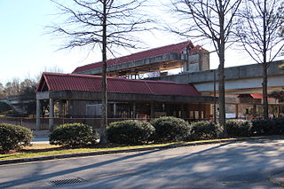
Chamblee is a train station in Chamblee, Georgia, serving the Gold Line of the Metropolitan Atlanta Rapid Transit Authority (MARTA) rail system. The station is bounded by New Peachtree Road on the East, Peachtree Road on the West and Chamblee Tucker road to the South. Chamblee Dunwoody Road is approximately ¼ mile to the north. A multi use trail has been completed between Keswick Park and Chamblee Tucker Road; this trail crosses under Peachtree Industrial Boulevard at Clairmont Road and ends at the Wal-Mart Shopping Center just southeast of the station. Chamblee has plans to connect this multi use trail at Keswick Park to an existing PATH trail that runs near Ashford Dunwoody Road between Blackburn Park and Murphey Candler Park. This station provides access to DeKalb-Peachtree Airport, Interactive College of Technology, Chamblee City Hall, and connecting bus service to Northlake Mall, Georgia State University, Peachford Hospital, Mercer University, Strayer University, the Georgia Vocational Rehabilitation Agency, North DeKalb Health Center, and the Veterans Administration Hospital.

<span class="mw-page-title-main">Airport station (MARTA)</span> MARTA rail station

Airport is an elevated rail station and southern terminus on the Red and Gold lines of the Metropolitan Atlanta Rapid Transit Authority (MARTA) rail system, located at Hartsfield Jackson Atlanta International Airport. It is served by the Gold Line at all times, while the Red Line generally serves it all day until 8:30 PM on weekdays and 8:50 PM on weekends when there is no scheduled track maintenance. It features one of only two Ridestores, the only other one being at Five Points.

<span class="mw-page-title-main">Bankhead station</span> MARTA rail station

Bankhead is a train station in Atlanta, Georgia, the western terminus of the Green Line in the Metropolitan Atlanta Rapid Transit Authority (MARTA) rail system. The Bankhead Marta Station is located in the Grove Park Neighborhood due to a recent neighborhood expansion. This station primarily serves the neighborhoods of Grove Park, Bankhead, West Lake, Howell Station, and other Westside residents. Bankhead Station provides connecting bus service to Donald Lee Hollowell Highway, Maddox Park, and the future Westside Park at Bellwood Quarry; which will be the largest park in the city of Atlanta

<span class="mw-page-title-main">North Springs station</span> MARTA rail station

North Springs is an elevated metro station in Sandy Springs, Georgia, and the northern terminus for the Red Line of the Metropolitan Atlanta Rapid Transit Authority (MARTA) rail system. North Springs is primarily a commuter station for Atlanta workers and university students, featuring a large parking deck and direct access on and off State Route 400, a major highway for commuters, so that drivers can avoid surface roads. North Springs attracts commuters from Roswell, Alpharetta and other towns north on State Route 400. As the northern terminus, this station is a hub for buses that continue on north, with connecting bus services to Sandy Springs, the city of Alpharetta, North Point Mall, the city of Roswell, the Ameris Bank Amphitheatre at Encore Park, the Mansell Road and Windward Parkway park-and-rides, and even as far north as the city of Milton. This station also provides bus assistance from North Springs High School via Route 87.

<span class="mw-page-title-main">MARTA rail</span> Subway network in Atlanta, Georgia, United states

The MARTA rail network, a component of the MARTA transit system in Metro Atlanta, has four service lines: the Red, Gold, Blue, and Green Lines. The Red and Gold Lines mainly run along the North-Northeast corridor, and the Blue and Green Lines run along the West-East corridor. The two corridors connect at the Five Points station, which is the only station where transfers are possible between all four lines. In 2022, the system had a ridership of 28,198,300, or about 91,000 per weekday as of the fourth quarter of 2022.

The Metropolitan Atlanta Rapid Transit Authority was created as the first public mass transit agency in metropolitan Atlanta. Its formation in 1965 was a result of the campaigning efforts of governmental planning agencies and Atlanta businessmen. The system broke ground on its rail system in 1975.

The transportation system of Georgia is a cooperation of complex systems of infrastructure comprising over 1,200 miles (1,900 km) of interstates and more than 120 airports and airbases serving a regional population of 59,425 people.

<span class="mw-page-title-main">Red Line (MARTA)</span>

The Red Line is a rapid transit line in the MARTA rail system. It operates between North Springs and Airport stations, running through Sandy Springs, Dunwoody, Atlanta, East Point and College Park.

The Blue Line is a rapid transit line in the MARTA rail system. It operates between Hamilton E. Holmes and Indian Creek stations, running through Atlanta, Decatur and portions of unincorporated DeKalb County.

The Green Line is a rapid transit line in the MARTA rail system. It operates between Bankhead and Edgewood / Candler Park stations, running exclusively inside the Atlanta city limits.

<span class="mw-page-title-main">Streetcars in Atlanta</span> Aspect of the history of Atlanta, Georgia, USA

Streetcars originally operated in Atlanta downtown and into the surrounding areas from 1871 until the final line's closure in 1949.

Atlanta's transportation system is a complex infrastructure of several systems, including 47.6 miles of heavy rail, 91 bus transit routes, 1,600 licensed taxis, a comprehensive network of freeways, the world's busiest airport and over 45 miles of bike paths.

References

  1. 1 2 Ariel Hart (2010-02-11). "MARTA changes "yellow" line to "gold"". Atlanta Journal-Constitution. Archived from the original on 2010-02-14. Retrieved 2010-02-11.
  2. "http://itsmarta.com/ne-dor-overview.aspx"
  3. "http://itsmarta.com/ne-cha-overview.aspx"
  4. "http://itsmarta.com/ne-bro-overview.aspx"
  5. "http://itsmarta.com/ne-len-overview.aspx"
  6. "http://itsmarta.com/ne-lin-overview.aspx"
  7. "http://itsmarta.com/ns-art-overview.aspx"
  8. "http://itsmarta.com/ns-mid-overview.aspx"
  9. "http://itsmarta.com/ns-nor-overview.aspx"
  10. "http://itsmarta.com/ns-civ-overview.aspx"
  11. "http://itsmarta.com/ns-pea-overview.aspx"
  12. "Peachtree Center Station Tour https://www.youtube.com/watch?v=2DDOKOpKmJA"
  13. 1 2 "Five Points Station Tour: https://www.youtube.com/watch?v=gkLKot2vk3Y"
  14. "Five Points Station http://itsmarta.com/ns-fiv-overview.aspx"
  15. "http://itsmarta.com/ns-gar-overview.aspx"
  16. "http://itsmarta.com/ns-wes-overview.aspx"
  17. "http://itsmarta.com/ns-oak-overview.aspx"
  18. "http://itsmarta.com/ns-lak-overview.aspx"
  19. "http://itsmarta.com/ns-eas-overview.aspx"
  20. "College Park Station http://itsmarta.com/ns-col-overview.aspx"
  21. "Airport Station Tour https://www.youtube.com/watch?v=wNcj6GOTen0"
  22. "Airport Station http://itsmarta.com/ne-air-overview.aspx"
  23. "http://itsmarta.com/ne-overview.aspx"

Route map:

Template:Attached KML/Gold Line (MARTA)
KML is from Wikidata