Golden City, Missouri

Last updated

Golden City, Missouri
Barton County Missouri Incorporated and Unincorporated areas Golden City Highlighted.svg
Location of Golden City, Missouri
Coordinates: 37°23′35″N94°05′39″W / 37.39306°N 94.09417°W / 37.39306; -94.09417
Country United States
State Missouri
County Barton
Township Golden City
Area
[1]
  Total1.04 sq mi (2.68 km2)
  Land1.03 sq mi (2.68 km2)
  Water0.00 sq mi (0.00 km2)
Elevation
[2]
1,060 ft (320 m)
Population
 (2020)
  Total656
  Density633.82/sq mi (244.81/km2)
Time zone UTC-6 (Central (CST))
  Summer (DST) UTC-5 (CDT)
ZIP code
64748
Area code 417
FIPS code 29-27676 [3]
GNIS feature ID2394923 [2]
Website www.goldencitymo.com

Golden City is a city in Golden City Township, Barton County, Missouri, United States. The population was 656 at the 2020 census. [4]

Contents

History

Golden City was established in 1867 as a stop on the Butterfield Stagecoach Line. It takes its name from a nearby area known as Golden Grove. [5] In reality the diggings were done by Indians mining an outcropping of exceptionally fine flint. Another rumor for its naming stems from the Indian dig sites, early settlers thought the flint mines were Spanish gold mines. It was re-platted in 1870. [6] The Golden City Herald served the community from 1881 until Dec. 28, 1972. Dellard Surbrugg published the newspaper and ran a commercial printing business from 1940 until he sold the paper to Gene Wotkiewicz, editor and publisher of the Lockwood Luminary.

2019 tornado

At approximately 9:30 PM on May 22, 2019, an EF-3 tornado struck the city. The storm killed three people and injured a few others. Many homes were unsalvageable. [7]

Geography

According to the United States Census Bureau, the city has a total area of 1.03 square miles (2.67 km2), all land. [8]

Golden City is located in the heart of Missouri Tall Grass Prairie country. Several preserved prairies are located within a few miles of town, the most significant of which are the Golden Prairie, the Cook Meadow and the Pennsylvania Prairie.

Demographics

Historical population
CensusPop.Note
1880 139
1890 773456.1%
1900 87513.2%
1910 8820.8%
1920 8991.9%
1930 828−7.9%
1940 8674.7%
1950 839−3.2%
1960 714−14.9%
1970 81013.4%
1980 90011.1%
1990 794−11.8%
2000 88411.3%
2010 765−13.5%
2020 656−14.2%
U.S. Decennial Census [9]

2010 census

As of the census [10] of 2010, there were 765 people, 325 households, and 197 families living in the city. The population density was 742.7 inhabitants per square mile (286.8/km2). There were 393 housing units at an average density of 381.6 per square mile (147.3/km2). The racial makeup of the city was 96.1% White, 0.1% African American, 1.7% Native American, 0.3% Asian, 0.7% from other races, and 1.2% from two or more races. Hispanic or Latino of any race were 1.4% of the population.

There were 325 households, of which 30.2% had children under the age of 18 living with them, 42.5% were married couples living together, 13.2% had a female householder with no husband present, 4.9% had a male householder with no wife present, and 39.4% were non-families. 33.2% of all households were made up of individuals, and 16.3% had someone living alone who was 65 years of age or older. The average household size was 2.34 and the average family size was 3.02.

The median age in the city was 38.5 years. 25.4% of residents were under the age of 18; 8.6% were between the ages of 18 and 24; 22% were from 25 to 44; 26% were from 45 to 64; and 17.8% were 65 years of age or older. The gender makeup of the city was 52.3% male and 47.7% female.

2000 census

As of the census [3] of 2000, there were 884 people, 369 households, and 225 families living in the city. The population density was 861.1 inhabitants per square mile (332.5/km2). There were 423 housing units at an average density of 412.0 per square mile (159.1/km2). The racial makeup of the city was 96.04% White, 1.92% Native American, 0.45% Asian, 0.11% from other races, and 1.47% from two or more races. Hispanic or Latino of any race were 2.15% of the population.

There were 369 households, out of which 29.5% had children under the age of 18 living with them, 47.4% were married couples living together, 10.0% had a female householder with no husband present, and 38.8% were non-families. 33.6% of all households were made up of individuals, and 16.0% had someone living alone who was 65 years of age or older. The average household size was 2.37 and the average family size was 3.08.

In the city the population was spread out, with 26.5% under the age of 18, 8.1% from 18 to 24, 27.0% from 25 to 44, 20.0% from 45 to 64, and 18.3% who were 65 years of age or older. The median age was 37 years. For every 100 females, there were 97.3 males. For every 100 females age 18 and over, there were 90.1 males.

The median income for a household in the city was $21,793, and the median income for a family was $25,347. Males had a median income of $21,875 versus $16,875 for females. The per capita income for the city was $11,192. About 14.6% of families and 23.2% of the population were below the poverty line, including 29.6% of those under age 18 and 28.5% of those age 65 or over.

Education

Public education in Golden City is administered by Golden City R-III School District, which operates one elementary school and Golden City High School. [11]

Golden City has a public library, a branch of the Barton County Library. [12]

Related Research Articles

<span class="mw-page-title-main">Prairie Village, Kansas</span> City in Kansas, United States

Prairie Village is a city in Johnson County, Kansas, United States, and located within the Kansas City Metropolitan Area. As of the 2020 census, the population of the city was 22,957.

<span class="mw-page-title-main">Parkers Prairie, Minnesota</span> City in Minnesota, United States

Parkers Prairie is a city in Otter Tail County, Minnesota, United States. The population was 1,020 at the 2020 census.

<span class="mw-page-title-main">Burgess, Missouri</span> Unincorporated community in the American state of Missouri

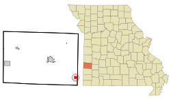
Burgess is a census-designated place and former village in Barton County, Missouri, United States. The population was 54 at the 2020 census.

<span class="mw-page-title-main">Lamar, Missouri</span> City in Missouri, United States

Lamar is a city in and the county seat of Barton County, Missouri, United States. As of the 2020 census, the city population was 4,266. It is known as the birthplace of Harry S. Truman, the 33rd president of the United States.

<span class="mw-page-title-main">Liberal, Missouri</span> City in Missouri, United States

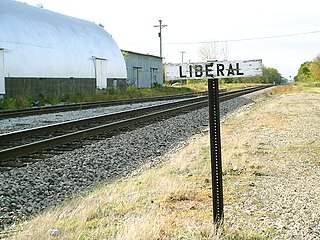
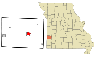
Liberal is a city in Barton County, Missouri, United States. The population was 629 at the 2020 census.

<span class="mw-page-title-main">Mindenmines, Missouri</span> City in Missouri, United States

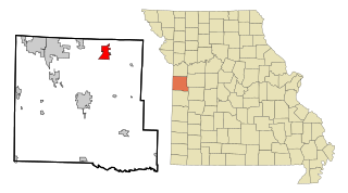
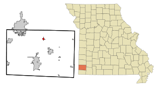
Mindenmines is a city in Barton County, Missouri, United States. The population was 271 at the 2020 census. The city lies approximately four miles east of Frontenac, Kansas. It has possessed a post office since 1883. It is also the home of the Bank of Minden..

<span class="mw-page-title-main">New Bloomfield, Missouri</span> City in Missouri, United States

New Bloomfield is a city in Cedar Township, Callaway County, Missouri, United States. The population was 669 at the 2010 census. It is part of the Jefferson City Metropolitan Statistical Area.

<span class="mw-page-title-main">Belton, Missouri</span> City in Missouri, US

Belton is a city in northwestern Cass County, Missouri, United States. The population was 23,953 at the 2020 census.

<span class="mw-page-title-main">Pleasant Hill, Missouri</span> City in Missouri, United States

Pleasant Hill is a city in Cass and Jackson counties, Missouri, United States. The population was 8,113 at the 2010 census. It is part of the Kansas City metropolitan area.

<span class="mw-page-title-main">Louisburg, Missouri</span> Village in Missouri, United States

Louisburg is a village in Dallas County, Missouri, United States. The population was 122 at the 2010 census. It is part of the Springfield, Missouri Metropolitan Statistical Area.

<span class="mw-page-title-main">Jasper, Missouri</span> City in Missouri, United States

Jasper is a city in Jasper County, Missouri, United States. The population within the city limits was 931 at the 2010 census. It is part of the Joplin, Missouri Metropolitan Statistical Area.

<span class="mw-page-title-main">Hazelwood, Missouri</span> City in Missouri, United States

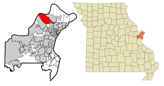
Hazelwood is a city in St. Louis County, Missouri, within Greater St. Louis. It is a second-ring northern suburb of St. Louis. Based on the 2020 United States census, the city had a total population of 25,485. It is located north of St. Louis-Lambert International Airport and is situated on Interstates 270 and 170, as well as the much-traveled Lindbergh Boulevard and Highway 370.

<span class="mw-page-title-main">Lakeshire, Missouri</span> City in Missouri, United States

Lakeshire is a city in St. Louis County, Missouri, United States. The population was 1,432 at the 2010 census.

<span class="mw-page-title-main">Olivette, Missouri</span> City in Missouri, United States

Olivette is an inner-ring suburb of St. Louis, located in St. Louis County, Missouri, United States. The population was 8,504 at the 2020 census.

<span class="mw-page-title-main">Sheldon, Missouri</span> City in Missouri, United States

Sheldon is a city in southern Vernon County, Missouri, United States. The population was 543 at the 2010 census.

<span class="mw-page-title-main">Prairie Home, Missouri</span> City in Missouri, United States

Prairie Home is a city, in Cooper County, Missouri, United States. The population was 280 at the 2010 census.

<span class="mw-page-title-main">East Prairie, Missouri</span> City in Missouri, United States

East Prairie is a city in Mississippi County, Missouri, United States. The population was 2,943 at the 2020 census, down from 3,176 in 2010.

<span class="mw-page-title-main">Diamond, Missouri</span> City in Missouri, United States

Diamond is a city in north central Newton County, Missouri, United States, located southeast of Joplin. The population was 831 at the 2020 census. It is part of the Joplin, Missouri, Metropolitan Statistical Area. Diamond is primarily renowned as the birthplace of George Washington Carver.

<span class="mw-page-title-main">Monroe City, Missouri</span> City in Missouri, United States

Monroe City is a city in Marion, Monroe, and Ralls counties in the U.S. state of Missouri. The population was 2,652 at the 2020 census.

<span class="mw-page-title-main">Dardenne Prairie, Missouri</span> Town in Missouri, United States

Dardenne Prairie is a city in St. Charles County, Missouri, United States. The population was 12,743 at the 2020 census.

References

  1. "ArcGIS REST Services Directory". United States Census Bureau. Retrieved August 28, 2022.
  2. 1 2 U.S. Geological Survey Geographic Names Information System: Golden City, Missouri
  3. 1 2 "U.S. Census website". United States Census Bureau . Retrieved January 31, 2008.
  4. "Explore Census Data". data.census.gov. Retrieved January 12, 2022.
  5. "Barton County Place Names, 1928-1945 (archived)". The State Historical Society of Missouri. Archived from the original on June 24, 2016. Retrieved August 31, 2016.{{cite web}}: CS1 maint: bot: original URL status unknown (link)
  6. Eaton, David Wolfe (1916). How Missouri Counties, Towns and Streams Were Named. The State Historical Society of Missouri. p. 207.
  7. "Missouri tornadoes". Kansascity.com. Retrieved February 2, 2022.
  8. "US Gazetteer files 2010". United States Census Bureau. Archived from the original on January 25, 2012. Retrieved July 8, 2012.
  9. "Census of Population and Housing". Census.gov. Retrieved June 4, 2015.
  10. "U.S. Census website". United States Census Bureau . Retrieved July 8, 2012.
  11. "Golden City R-Iii School District". Great Schools. Retrieved June 2, 2019.
  12. "Hours and Locations". Barton County Library. Archived from the original on June 4, 2019. Retrieved June 4, 2019.