Gordon, Nebraska | |
---|---|
Coordinates: 42°48′24″N102°12′14″W / 42.80667°N 102.20389°W [1] | |
Country | United States |
State | Nebraska |
County | Sheridan |
Incorporated | 1885 |
Area | |
• Total | 0.93 sq mi (2.41 km2) |
• Land | 0.93 sq mi (2.41 km2) |
• Water | 0.00 sq mi (0.00 km2) |
Elevation | 3,557 ft (1,084 m) |
Population (2020) | |
• Total | 1,504 |
• Density | 1,615.47/sq mi (623.44/km2) |
Time zone | UTC-7 (Mountain (MST)) |
• Summer (DST) | UTC-6 (MDT) |
ZIP code | 69343 |
Area code | 308 |
FIPS code | 31-19350 |
GNIS feature ID | 2394933 [1] |
Website | gordon-ne.us |
Gordon is a city in Sheridan County, Nebraska, United States, in the Great Plains region. [1] Its population was 1,612 at the 2010 census. [3]
Gordon was incorporated as a village in 1885 when the railroad was extended to that point. [4] It was named for John Gordon, a pioneer settler. [5] [6] Gordon was incorporated in November 1885. [7]
In the Lakota language, Gordon is known as tȟáȟča wakpá otȟúŋwahe, meaning "deer river city". [8]
Census | Pop. | Note | %± |
---|---|---|---|
1900 | 542 | — | |
1910 | 920 | 69.7% | |
1920 | 1,581 | 71.8% | |
1930 | 1,958 | 23.8% | |
1940 | 1,967 | 0.5% | |
1950 | 2,058 | 4.6% | |
1960 | 2,223 | 8.0% | |
1970 | 2,106 | −5.3% | |
1980 | 2,167 | 2.9% | |
1990 | 1,803 | −16.8% | |
2000 | 1,756 | −2.6% | |
2010 | 1,612 | −8.2% | |
2020 | 1,504 | −6.7% | |
U.S. Decennial Census |
As of the census [9] of 2010, there were 1,612 people, 685 households, and 420 families living in the city. The population density was 1,733.3 inhabitants per square mile (669.2/km2). There were 806 housing units at an average density of 866.7 per square mile (334.6/km2). The racial makeup of the city was 75.6% White, 0.2% African American, 20.0% Native American, 0.5% Asian, 0.1% Pacific Islander, 0.6% from other races, and 3.0% from two or more races. Hispanic or Latino of any race were 4.2% of the population.
There were 685 households, of which 30.1% had children under the age of 18 living with them, 44.4% were married couples living together, 12.4% had a female householder with no husband present, 4.5% had a male householder with no wife present, and 38.7% were non-families. 36.2% of all households were made up of individuals, and 18% had someone living alone who was 65 years of age or older. The average household size was 2.30 and the average family size was 2.98.
The median age in the city was 42.7 years. 26.4% of residents were under the age of 18; 7.2% were between the ages of 18 and 24; 18.6% were from 25 to 44; 26% were from 45 to 64; and 21.8% were 65 years of age or older. The gender makeup of the city was 47.5% male and 52.5% female.
As of the census [10] of 2000, there were 1,756 people, 733 households, and 467 families living in the city. The population density was 1,881.0 inhabitants per square mile (726.3/km2). There were 825 housing units at an average density of 883.7 per square mile (341.2/km2). The racial makeup of the city was 82.35% White, 15.43% Native American, 0.28% Asian, 0.06% Pacific Islander, 0.28% from other races, and 1.59% from two or more races. Hispanic or Latino of any race were 1.65% of the population.
There were 733 households, out of which 29.9% had children under the age of 18 living with them, 48.2% were married couples living together, 12.6% had a female householder with no husband present, and 36.2% were non-families. 33.2% of all households were made up of individuals, and 19.2% had someone living alone who was 65 years of age or older. The average household size was 2.33 and the average family size was 2.97.
In the city, the population was spread out, with 27.4% under the age of 18, 6.7% from 18 to 24, 21.1% from 25 to 44, 21.0% from 45 to 64, and 23.8% who were 65 years of age or older. The median age was 41 years. For every 100 females, there were 84.5 males. For every 100 females age 18 and over, there were 77.3 males.
As of 2000 the median income for a household in the city was $27,896, and the median income for a family was $35,139. Males had a median income of $27,656 versus $16,927 for females. The per capita income for the city was $14,105. About 13.4% of families and 15.6% of the population were below the poverty line, including 24.5% of those under age 18 and 8.0% of those age 65 or over.
According to the United States Census Bureau, the city has a total area of 0.93 square miles (2.41 km2), all land. [11]
Climate data for Gordon 6N, Nebraska (1991–2020 normals, extremes 1909–present) | |||||||||||||
---|---|---|---|---|---|---|---|---|---|---|---|---|---|
Month | Jan | Feb | Mar | Apr | May | Jun | Jul | Aug | Sep | Oct | Nov | Dec | Year |
Record high °F (°C) | 70 (21) | 75 (24) | 86 (30) | 92 (33) | 98 (37) | 106 (41) | 110 (43) | 106 (41) | 105 (41) | 95 (35) | 81 (27) | 72 (22) | 110 (43) |
Mean maximum °F (°C) | 54.8 (12.7) | 58.1 (14.5) | 72.9 (22.7) | 80.5 (26.9) | 88.4 (31.3) | 94.2 (34.6) | 98.5 (36.9) | 98.1 (36.7) | 94.2 (34.6) | 83.4 (28.6) | 69.8 (21.0) | 57.7 (14.3) | 100.1 (37.8) |
Average high °F (°C) | 34.2 (1.2) | 36.6 (2.6) | 47.3 (8.5) | 56.1 (13.4) | 66.4 (19.1) | 78.2 (25.7) | 86.1 (30.1) | 84.8 (29.3) | 75.4 (24.1) | 59.7 (15.4) | 46.1 (7.8) | 35.1 (1.7) | 58.8 (14.9) |
Daily mean °F (°C) | 23.6 (−4.7) | 25.7 (−3.5) | 35.0 (1.7) | 43.6 (6.4) | 53.9 (12.2) | 65.0 (18.3) | 72.0 (22.2) | 70.5 (21.4) | 61.1 (16.2) | 46.7 (8.2) | 34.2 (1.2) | 24.7 (−4.1) | 46.3 (7.9) |
Average low °F (°C) | 12.9 (−10.6) | 14.7 (−9.6) | 22.7 (−5.2) | 31.0 (−0.6) | 41.3 (5.2) | 51.7 (10.9) | 57.9 (14.4) | 56.2 (13.4) | 46.7 (8.2) | 33.8 (1.0) | 22.3 (−5.4) | 14.2 (−9.9) | 33.8 (1.0) |
Mean minimum °F (°C) | −10.2 (−23.4) | −6.7 (−21.5) | 2.6 (−16.3) | 16.5 (−8.6) | 27.2 (−2.7) | 40.8 (4.9) | 48.5 (9.2) | 45.8 (7.7) | 33.0 (0.6) | 16.0 (−8.9) | 2.4 (−16.4) | −6.9 (−21.6) | −16.1 (−26.7) |
Record low °F (°C) | −40 (−40) | −40 (−40) | −31 (−35) | −15 (−26) | 12 (−11) | 23 (−5) | 31 (−1) | 27 (−3) | 1 (−17) | −11 (−24) | −25 (−32) | −40 (−40) | −40 (−40) |
Average precipitation inches (mm) | 0.52 (13) | 0.62 (16) | 1.18 (30) | 2.25 (57) | 3.24 (82) | 3.85 (98) | 2.54 (65) | 1.80 (46) | 1.68 (43) | 1.62 (41) | 0.70 (18) | 0.50 (13) | 20.50 (521) |
Average snowfall inches (cm) | 6.5 (17) | 7.3 (19) | 8.1 (21) | 7.0 (18) | 1.7 (4.3) | 0.0 (0.0) | 0.0 (0.0) | 0.0 (0.0) | 0.1 (0.25) | 2.7 (6.9) | 5.8 (15) | 6.6 (17) | 45.8 (116) |
Average precipitation days (≥ 0.01 in) | 4.0 | 4.6 | 6.0 | 9.0 | 10.0 | 10.7 | 7.7 | 6.4 | 5.4 | 6.5 | 4.2 | 3.8 | 78.3 |
Average snowy days (≥ 0.1 in) | 3.5 | 3.6 | 3.2 | 2.6 | 0.3 | 0.0 | 0.0 | 0.0 | 0.2 | 1.1 | 2.6 | 3.5 | 20.6 |
Source: NOAA [12] [13] |
Louisville is a city in northern Cass County, Nebraska, United States. The population was 1,319 at the 2020 census.
Chadron is a city and the county seat of Dawes County, Nebraska, United States, in the Great Plains region. The population was 5,851 at the 2010 census. This city is the location of Chadron State College.
Bennington is a city in Douglas County, Nebraska, United States. The population was 2,026 at the 2020 U.S. Census.
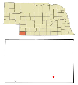
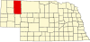
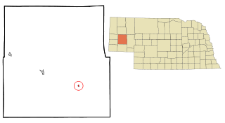
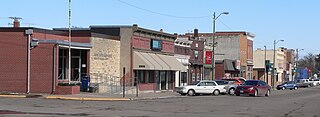
Benkelman is a city in and the county seat of Dundy County, Nebraska, United States. As of the 2020 census, the city population was 821.
Madison is a city in and the county seat of Madison County, Nebraska, United States. The population was 2,283 at the 2020 census.
Broadwater is a village in Morrill County, Nebraska, United States. The population was 128 at the 2010 census.
Pawnee City is a city in and the county seat of Pawnee County, Nebraska, United States. The population was 878 at the 2010 census.
Grant is a city and county seat of Perkins County, Nebraska, United States. The population was 1,165 at the 2010 census.
Verdon is a village in Richardson County, Nebraska, United States. The population was 164 at the 2020 census.
Bassett is a city in Rock County, Nebraska, United States. The population was 619 at the 2010 census. It is the county seat of Rock County.
Yutan is a city in Saunders County, Nebraska, United States.
Rushville is a city in Sheridan County, Nebraska, United States, in the remote Sandhills Region. Its population was 890 at the 2010 census. It is the county seat of Sheridan County.
Stanton is a city in Stanton County, Nebraska, United States. The population was 1,577 at the 2010 census. It is the county seat of Stanton County. Stanton was platted in 1870. Both the city and county are named after Edwin Stanton, secretary of war for president Abraham Lincoln during the American Civil War.
Fort Calhoun is a city in Washington County, Nebraska, United States. The population was 908 at the 2010 census. The city includes Fort Atkinson, the first fort built west of the Missouri River.
Blue Hill is a town in Webster County, Nebraska, United States. The population was 936 at the 2010 census.
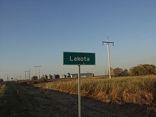
Lakota is a city in Nelson County, North Dakota, United States. It is the county seat of Nelson County Lakota is located 63 miles west of Grand Forks and 27 miles east of Devils Lake. The population was 683 at the 2020 census, making Lakota the 76th-largest city in North Dakota.
Martin is a city and the county seat of Bennett County, South Dakota, United States. The population was 938 at the 2020 census.
Chamberlain is a city in Brule County, South Dakota, United States. It is located on the east bank of the Missouri River, at the dammed section of the Lake Francis Case, close to where it is crossed by Interstate 90.
White River is a city in and the county seat of Mellette County. South Dakota, United States. The population was 533 at the 2020 census.
New Underwood is a city in Pennington County, South Dakota, United States. The population was 590 at the 2020 Census.
{{cite web}}
: CS1 maint: unfit URL (link)