Gore Highway

Last updated

Gore Highway

Gore Highway 0116.svg
Gore Highway (green and black)
General information
TypeHighway
Length197 km (122 mi)
Route number(s) AUS Alphanumeric Route A39.svg National Highway A39
Former
route number
Australian national highway 85.svg National Highway 85
  • Australian national highway A39.svg
  • Australian national highway 39.svg
Major junctions
West endAUS Alphanumeric Route A5.svg Leichhardt Highway , 19 kilometres (12 mi) north of Goondiwindi
 AUS Alphanumeric Route A139.svg Toowoomba Athol Road
East endAUS Alphanumeric Route A2.svg Warrego Highway , Charlton
Location(s)
Major settlements Millmerran, Pittsworth
Highway system

The Gore Highway is a highway running between Toowoomba and Goondiwindi in Queensland, Australia. Together with Goulburn Valley Highway and Newell Highway, it is a part of the National Highway's Melbourne-Brisbane link. It is signed as National Highway A39. [1]

Contents

History

The highway is named after two brothers, St. George Richard Gore and Ralph Thomas Gore who established the Yandilla pastoral run in the area (between Pittsworth and Milmerran), through which the road traverses. [2]

It was elevated to National Highway status in February 1993, and replaced the Cunningham Highway as the main route between Goondiwindi and Brisbane. Interstate traffic was rerouted through Toowoomba and the Warrego Highway as it presented a less steep gradient than via Warwick and Cunninghams Gap, shortening travel time especially for trucks. It was initially designated State Route 85 until February 1993 when National Highway 85 was proclaimed, splitting State Route 85 into two. In 2005 it was given the National Highway A39 designation. [3]

Southbrook, 2014 Gore Highway at Southbrook.jpg
Southbrook, 2014

The Toowoomba Bypass was completed in September 2019. It bypasses the urban area of Toowoomba and provides a better crossing of the Great Dividing Range. Gore Highway (A39) was rerouted via the bypass between Athol (in the south) and the Warrego Highway (A2) interchange at Charlton. The original section of Gore Highway to Toowoomba was renamed Toowoomba Athol Road (A139). [4]

Route description

The highway passes through Queensland's Darling Downs region. Typical of the scenery are grazing cattle, orchards and grain farmland. It is concurrent with State route 85 from Goondiwindi to Athol, and with State route 82 from Milmerran to Pampas.

Approximate road distances (in kilometres) of towns from Toowoomba along the highway A39Gorehighway.PNG
Approximate road distances (in kilometres) of towns from Toowoomba along the highway

Speed zones

The highway has two different speed zones. From Athol to Millmerran (60 kilometres (37 mi) south west) it is 100 kilometres per hour (62 mph). Between Millmerran and Goondiwindi the maximum permitted speed is 110 kilometres per hour (68 mph).

Towns and localities

Roads of Strategic Importance upgrades

The Roads of Strategic Importance initiative, last updated in March 2022, includes the following projects for the Gore Highway.

Road upgrades

A lead project to upgrade Queensland sections of the Toowoomba to Seymour corridor, including the Gore Highway and surrounding state and council roads, at an estimated cost of $62.5 million, was to commence in 2020 and is scheduled for completion in mid-2028. [5]

Road surface rehabilitation

A project for surface rehabilitation of a section of the Gore Highway between Pittsworth and Millmerran at a cost of $17 million is planned to be completed by mid-2023. [6]

Other upgrades

A project to plan safety upgrades on the Gore Highway and the Toowoomba - Athol Road, at a cost of $400,000, was completed in December 2021. [7]

Major intersections

LGALocationkmmiDestinationsNotes
Goondiwindi Goondiwindi 00.0AUS Alphanumeric Route A5.svg Leichhardt Highway (State Highway A5) north - Moonie /
south - Goondiwindi
Western end of Gore Highway. Intersection is 19 kilometres (12 mi) north of Goondiwindi CBD.
Western end of State Route 85 concurrency.
Toowoomba Milmerran 12477Australian state route 82.svg Milmerran-Inglewood Road (State Route 82) - Inglewood Western end of State Route 82 concurrency.
Pampas 13986Australian state route 82.svg Pampas Horrane Road (State Route 82) - Cecil Plains Eastern end of State Route 82 concurrency.
Athol 184114AUS Alphanumeric Route A139.svg Toowoomba Athol Road (A139) - Toowoomba Eastern end of State Route 85 concurrency.
No entry to Gore Highway northbound from Toowoomba Athol Road
Charlton 197122AUS Alphanumeric Route A2.svg Warrego Highway (National Route A2) west - Dalby /
north - Cranley
AUS Alphanumeric Route A21.svg Toowoomba Connection Road (A21) east - Toowoomba
Eastern end of Gore Highway.
1.000 mi = 1.609 km; 1.000 km = 0.621 mi

Toowoomba Athol Road (A139)

Toowoomba Athol Road

AUS Alphanumeric Route A139.svg

LocationGore Highway to Toowoomba
Length17.1 km (10.6 mi)
Existed2019–present
Route number 139

The Toowoomba Athol Road is a 17.1 km (10.6 mi) former section of the Gore Highway that runs south-west from the city of Toowoomba in Queensland, Australia. With the opening of the Toowoomba Bypass in 2019 the Gore Highway was redirected to part of it, and the bypassed section of the highway was renamed Toowoomba Athol Road and assigned the route number A139.

A139 Route description

The road commences at an intersection with the Toowoomba Connection Road (A21) on the midpoint of the Toowoomba suburbs of Newtown and Harristown. It runs south-west through the residential suburb of Harristown and the rural suburbs of Drayton and Westbrook to the rural locality of Athol, where it ends at an intersection with the Gore Highway. It is concurrent with State Route 85. There are no major intersections on this road.

A139 History

In 1849 government surveyor James Charles Burnett prepared a design for the town of Drayton and chose a site 3–4 miles (4.8–6.4 km) to the north-east for suburban allotments of 27–40 acres (11–16 ha). Located where two swampy creeks converged as the headwaters of Gowrie Creek, this area was known as The Swamp/s or the Drayton Swamp, and later as Toowoomba. When preparing the detailed survey of Drayton in 1850, Burnett added a cemetery to the north of the village, midway between Drayton town and the Drayton Swamp suburban allotments, on slightly elevated land close to the road connecting the two settlements. [8] This road, later named Anzac Avenue, is now part of Toowoomba Athol Road.

The Toowoomba Bypass was completed in September 2019 and bypasses the urban area of Toowoomba and provides a better crossing of the Great Dividing Range. The Warrego Highway (A2) was rerouted via the bypass between Helidon Spa (in the east) and an interchange at Charlton (in the west). The Gore Highway (A39) was rerouted via the bypass between Charlton and Athol, and the original section of Gore Highway from Toowoomba to Athol was renamed Toowoomba Athol Road (A139). [4]

See also

Related Research Articles

<span class="mw-page-title-main">Warrego Highway</span> Highway in Queensland

The Warrego Highway is located in southern Queensland, Australia. It connects coastal centres to the south western areas of the state, and is approximately 715 km in length. It takes its name from the Warrego River, which is the endpoint of the highway. The entire highway is part of the National Highway system linking Darwin and Brisbane: formerly National Highway 54, Queensland began to convert to the alphanumeric system much of Australia had adopted in the early-2000s and this road is now designated as National Highway A2.

<span class="mw-page-title-main">Leichhardt Highway</span>

The Leichhardt Highway is a major transport route in Queensland, Australia. It is a continuation northward from Goondiwindi of the Newell Highway, via a 2.0-kilometre (1.2 mi) section of the Cunningham Highway.

<span class="mw-page-title-main">Shire of Jondaryan</span> Local government area in Queensland, Australia

The Shire of Jondaryan was a local government area located in the Darling Downs region of Queensland, Australia, immediately west of the regional city of Toowoomba. The shire, administered from the town of Oakey, covered an area of 1,910.0 square kilometres (737.5 sq mi), and existed as a local government entity from 1890 until 2008, when it amalgamated with several other councils in the Toowoomba area to form the Toowoomba Region. Its growth in later years has been fuelled by the expansion of Toowoomba and suburbs such as Glenvale and Westbrook.

<span class="mw-page-title-main">D'Aguilar Highway</span> Highway in Queensland, Australia

The D'Aguilar Highway is a two-lane highway linking the Bruce Highway near Caboolture with Kingaroy in the state of Queensland, Australia. Major towns along the route include Woodford, Kilcoy, Blackbutt, Yarraman, Nanango and Kingaroy. The highway is approximately 164 km (102 mi) in length. The D'Aguilar Highway's highest elevation along its length is 527 m just north of Yarraman, and the lowest point is at 26.8m just west of Caboolture.

<span class="mw-page-title-main">Shire of Millmerran</span> Local government area in Queensland, Australia

The Shire of Millmerran was a local government area in the Darling Downs region of Queensland, Australia, about 80 kilometres (50 mi) southwest of the regional city of Toowoomba. The shire covered an area of 4,520.8 square kilometres (1,745.5 sq mi), and existed as a local government entity from 1913 until 2008, when it amalgamated with several other councils in the Toowoomba area to become the Toowoomba Region.

<span class="mw-page-title-main">Millmerran, Queensland</span> Town in Queensland, Australia

Millmerran, known as Domville between 1 June 1889 and 16 November 1894, is a town and a locality in the Toowoomba Region, Queensland, Australia. In the 2016 census, the locality of Millmerran had a population of 1,563 people.

Wyreema is a rural town and locality in the Toowoomba Region, Queensland, Australia. In the 2016 census, the locality of Wyreema had a population of 1,834 people.

<span class="mw-page-title-main">Millmerran railway line</span> Railway line in Queensland, Australia

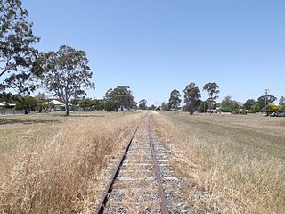
The Millmerran railway line is a 71 kilometre long branch railway in the Darling Downs region of Queensland, Australia.

<span class="mw-page-title-main">Charlton, Queensland</span> Suburb of Toowoomba Region, Queensland, Australia

Charlton is a rural locality in the Toowoomba Region, Queensland, Australia, located 13 kilometres (8 mi) west from the Toowoomba city centre off the Warrego Highway. In the 2016 census, Charlton had a population of 120 people.

Yandilla is a rural locality in the Toowoomba Region, Queensland, Australia. In the 2016 census Yandilla had a population of 46 people.

<span class="mw-page-title-main">Toowoomba Bypass</span> Road in Queensland, Australia

The Toowoomba Bypass, known as Toowoomba Second Range Crossing during planning and construction, is a 41.3 km (25.7 mi) grade separated, dual carriageway bypass and partial ring road constructed to the north and west of Toowoomba, Queensland. Construction commenced in April 2016. It opened to traffic on 8 September 2019.

<span class="mw-page-title-main">All Saints Anglican Church, Yandilla</span> Historic site in Queensland, Australia

All Saints Anglican Church and cemetery Yandilla is a heritage-listed Anglican church at Gore Highway, Yandilla, Toowoomba Region, Queensland, Australia. It was built about 1878 by John Baillie. It is also known as All Saints Church of England. It was added to the Queensland Heritage Register on 21 October 1992.

Captains Mountain is a locality in the Toowoomba Region, Queensland, Australia. In the 2016 census, Captains Mountain had a population of 77 people.

<span class="mw-page-title-main">Toowoomba Connection Road</span>

The Toowoomba Connection Road is a 27.3 km (17.0 mi) former section of the Warrego Highway that passes through the city of Toowoomba in Queensland, Australia. With the opening of the Toowoomba Bypass in 2019 the Warrego Highway was redirected to it, and the bypassed section of the highway was renamed Toowoomba Connection Road and assigned the route number A21.

Oakey–Cooyar Road is a continuous 58.8 kilometres (36.5 mi) road route in the Darling Downs and Toowoomba regions of Queensland, Australia. The entire route is signed as State Route 68. It is a state-controlled part regional and part district road . It provides an alternate route between the Warrego Highway and the New England Highway, bypassing Toowoomba.

Chinchilla–Wondai Road is a continuous 151.6 kilometres (94.2 mi) road route in the Western Downs and South Burnett regions of Queensland, Australia. Part of the route is signed as State Route 82. It is a state-controlled part regional and part district road. It provides an alternate route between the Warrego Highway and the South Burnett, bypassing Dalby, Oakey and Toowoomba.

Toowoomba–Karara Road is a continuous 82.5 kilometres (51.3 mi) road route in the Toowoomba and Southern Downs regions of Queensland, Australia. Most of the route is signed as State Route 48. Toowoomba–Karara Road is a state-controlled district road. As part of State Route 48 it provides an alternate route between Toowoomba and Inglewood. It is also part of the shortest route from Toowoomba to Texas.

Toowoomba–Cecil Plains Road is a continuous 78.6 kilometres (48.8 mi) road route in the Toowoomba region of Queensland, Australia. Most of the road is not signed with any route number, but a short section near Cecil Plains is part of State Route 82. Toowoomba–Cecil Plains Road is a state-controlled district road, part of which is rated as a local road of regional significance (LRRS).

Millmerran–Inglewood Road is a continuous 68.8 kilometres (42.8 mi) road route in the Toowoomba and Goondiwindi regions of Queensland, Australia. The road is signed as State Route 82. Millmerran–Inglewood Road is a state-controlled regional road.

There are two state-controlled roads linking Millmerran and Cecil Plains in the Toowoomba region of Queensland, Australia. They are Millmerran–Cecil Plains Road, which runs to the west of the Condamine River, and Pampas–Horrane Road, which runs east of the river.

References

  1. Queensland Government - Department of Transport and Main Roads - Maps
  2. "Gore Highway" . Retrieved 23 May 2013.[ self-published source ]
  3. Hema, Maps (2007). Australia Road and 4WD Atlas (Map). Eight Mile Plains Queensland: Hema Maps. p. 9. ISBN   978-1-86500-456-3.
  4. 1 2 "Toowoomba Bypass". Department of Transport and Main Roads. Retrieved 5 August 2020.
  5. "Toowoomba to Seymour - Queensland". Department of Infrastructure, Transport, Regional Development and Communications. 13 October 2020. Retrieved 6 May 2022.
  6. "Gore Highway (Pittsworth to Millmerran) Road Surface Rehabilitation". Department of Infrastructure, Transport, Regional Development and Communications. 19 May 2021. Retrieved 6 May 2022.
  7. "Gore Highway and Toowoomba-Athol Road safety upgrades—planning". Queensland Government. 6 January 2022. Retrieved 22 June 2022.
  8. "Drayton and Toowoomba Cemetery (entry 602718)". Queensland Heritage Register . Queensland Heritage Council. Retrieved 1 August 2014.