
The Baltic Sea is an arm of the Atlantic Ocean that is enclosed by Denmark, Estonia, Finland, Germany, Latvia, Lithuania, Poland, Russia, Sweden and the North and Central European Plain.

The Black Sea is a marginal mediterranean sea lying between Europe and Asia, east of the Balkans, south of the East European Plain, west of the Caucasus, and north of Anatolia. It is bounded by Turkey, Bulgaria, Romania, Ukraine, Russia and Georgia. The Black Sea is supplied by major rivers, principally the Danube, Dnieper and Don. Consequently, while six countries have a coastline on the sea, its drainage basin includes parts of 24 countries in Europe.

The Challenger Deep is the deepest known point of the seabed of Earth. Its depth is measured at 10,902–10,929 m (35,768–35,856 ft) by direct measurement from deep-diving submersibles, remotely operated underwater vehicles and benthic landers, and (sometimes) slightly more by sonar bathymetry.
Truso was a Viking Age port of trade (emporium) set up by the Scandinavians at the banks of the Nogat delta branch of the Vistula River, close to a bay, where it emptied into the shallow and brackish Vistula Lagoon. This sizeable lagoon is separated from the Gdańsk Bay by the Vistula Spit at the southern Baltic Sea coast. In the 9th century, the merchant Wulfstan of Hedeby travelled to Truso in the service of the English King Alfred the Great and wrote his account of the place at a prominent location of the Amber Road, which attracted merchants from central and southern Europe, who supplied the markets in the Mediterranean and the Middle East with the highly valued commodity.

Lake Van is the largest lake in Turkey. It lies in the far east of Turkey, in the provinces of Van and Bitlis in the Armenian highlands. It is a saline soda lake, receiving water from many small streams that descend from the surrounding mountains. It is one of the world's few endorheic lakes of size greater than 3,000 square kilometres (1,200 sq mi) and has 38% of the country's surface water. A volcanic eruption blocked its original outlet in prehistoric times. It is situated at 1,640 m (5,380 ft) above sea level. Despite the high altitude and winter lows below 0 °C (32 °F), high salinity usually prevents it from freezing; the shallow northern section can freeze, but rarely.

The Andaman Sea is a marginal sea of the northeastern Indian Ocean bounded by the coastlines of Myanmar and Thailand along the Gulf of Martaban and west side of the Malay Peninsula, and separated from the Bay of Bengal to its west by the Andaman Islands and the Nicobar Islands. Its southern end is at Breueh Island just north of Sumatra, with the Strait of Malacca further southeast.

Polymetallic nodules, also called manganese nodules, are mineral concretions on the sea bottom formed of concentric layers of iron and manganese hydroxides around a core. As nodules can be found in vast quantities, and contain valuable metals, deposits have been identified as a potential economic interest.
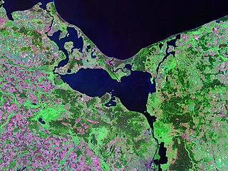
Szczecin Lagoon, also known as Oder Lagoon, and Pomeranian Lagoon, is a lagoon in the Oder estuary, shared by Germany and Poland. It is separated from the Pomeranian Bay of the Baltic Sea by the islands of Usedom and Wolin. The lagoon is subdivided into the Kleines Haff in the West and the Wielki Zalew in the East. An ambiguous historical German name was Frisches Haff, which later exclusively referred to the Vistula Lagoon.

The seabed is the bottom of the ocean. All floors of the ocean are known as 'seabeds'.
An inland sea is a continental body of water which is very large in area and is either completely surrounded by dry land or connected to an ocean by a river, strait or "arm of the sea". An inland sea will generally have higher salinity than a freshwater lake, but usually lower salinity than seawater. As with other seas, inland seas experience tides governed by the orbits of the Moon and Sun.
Anoxic waters are areas of sea water, fresh water, or groundwater that are depleted of dissolved oxygen. The US Geological Survey defines anoxic groundwater as those with dissolved oxygen concentration of less than 0.5 milligrams per litre. Anoxic waters can be contrasted with hypoxic waters, which are low in dissolved oxygen. This condition is generally found in areas that have restricted water exchange.

The Åland Sea is a waterway in the southern Gulf of Bothnia, between Åland and Sweden. It connects the Bothnian Sea with the Baltic Sea proper. The western part of the basin is in Swedish territorial waters while the eastern part is in Finnish territorial waters.

Gotland is made up of a sequence of sedimentary rocks of a Silurian age, dipping to the south-east. The main Silurian succession of limestones and shales comprises thirteen units spanning 200–500 m (660–1,640 ft) of stratigraphic thickness, being thickest in the south, and overlies a 75–125 m (246–410 ft) thick Ordovician sequence. Precambrian shield rocks that underlie these sediments are found 400 to 500 meters sea level. Sedimentary rocks cropping out in Gotland were deposited in a shallow, hot and salty sea, on the edge of an equatorial continent. The water depth never exceeded 175–200 m (574–656 ft), and shallowed over time as bioherm detritus, and terrestrial sediments, filled the basin. Reef growth started in the Llandovery, when the sea was 50–100 m (160–330 ft) deep, and reefs continued to dominate the sedimentary record. Some sandstones are present in the youngest rocks towards the south of the island, which represent sand bars deposited very close to the shore line.

The Vistula is the longest river in Poland and the ninth-longest river in Europe, at 1,047 kilometres in length. Its drainage basin, extending into three other countries apart from Poland, covers 193,960 km2 (74,890 sq mi), of which 168,868 km2 (65,200 sq mi) is in Poland.
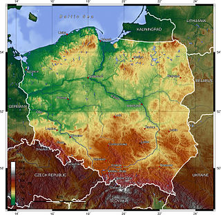
Poland is a country that extends across the North European Plain from the Sudetes and Carpathian Mountains in the south to the sandy beaches of the Baltic Sea in the north. Poland is the fifth-most populous country of the European Union and the ninth-largest country in Europe by area. The territory of Poland covers approximately 312,696 km2 (120,733 sq mi), of which 98.52% is land and 1.48% is water. The Polish coastline was estimated at 770 km (478 mi) in length. Poland's highest point is Mount Rysy, at 2,501 m (8,205 ft).

Topography of Croatia is defined through three major geomorphological parts of the country. Those are the Pannonian Basin, the Dinaric Alps, and the Adriatic Basin. The largest part of Croatia consists of lowlands, with elevations of less than 200 metres above sea level recorded in 53.42% of the country. Bulk of the lowlands are found in the northern regions of the country, especially in Slavonia, itself a part of the Pannonian Basin plain. The plains are interspersed by the horst and graben structures, believed to break the Pannonian Sea surface as islands. The greatest concentration of ground at relatively high elevations is found in Lika and Gorski Kotar areas in the Dinaric Alps, but such areas are found in all regions of Croatia to some extent. The Dinaric Alps contain the highest mountain in Croatia—1,831-metre (6,007 ft) Dinara, as well as all other mountains in Croatia higher than 1,500 metres. Croatia's Adriatic Sea mainland coast is 1,777.3 kilometres long, while its 1,246 islands and islets encompass further 4,058 kilometres of coastline—the most indented coastline in the Mediterranean. Karst topography makes up about half of Croatia and is especially prominent in the Dinaric Alps, as well as throughout the coastal areas and the islands.
The geology of the Baltic Sea is characterized by having areas located both at the Baltic Shield of the East European Craton and in the Danish-North German-Polish Caledonides. Historical geologists make a distinction between the current Baltic Sea depression, formed in the Cenozoic era, and the much older sedimentary basins whose sediments are preserved in the zone. Although glacial erosion has contributed to shape the present depression, the Baltic trough is largely a depression of tectonic origin that existed long before the Quaternary glaciation.
In north European geology, Jotnian sediments are a group of Precambrian rocks more specifically assigned to the Mesoproterozoic Era (Riphean), albeit some might be younger. Jotnian sediments include the oldest known sediments in the Baltic area that have not been subject to metamorphism. Stratigraphically, Jotnian sediments overlie the rapakivi granites and other igneous and metamorphic rocks and are often intruded by younger diabases.

The geology of Germany is heavily influenced by several phases of orogeny in the Paleozoic and the Cenozoic, by sedimentation in shelf seas and epicontinental seas and on plains in the Permian and Mesozoic as well as by the Quaternary glaciations.

International Dialogues on Underwater Munitions (IDUM) is a non-governmental organization (NGO) that was founded in Canada in 2004 and established as a Dutch Foundation in The Hague, The Netherlands in 2014. The IDUM was founded by Terrance P. Long CPSM.SSM. CD., a retired Canadian Military Engineer with more than thirty years of experience, having served in Explosive Ordnance Disposal (EOD) Centre Chief, and demining expert all over the world. His expertise and passion for marine ecosystems led to the birth of IDUM.
