
Niagara Falls is a city in Ontario, Canada. It is on the western bank of the Niagara River in the Golden Horseshoe region of Southern Ontario, with a population of 88,071 at the 2016 census. It is part of the St. Catharines - Niagara Census Metropolitan Area (CMA). Incorporated on 12 June 1903, the city is across the river from Niagara Falls, New York. The Niagara River flows over Niagara Falls at this location, creating a natural spectacle which attracts millions of tourists each year.
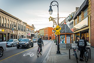
St. Catharines is the largest city in Canada's Niagara Region and the sixth largest urban area in the province of Ontario. As of 2016, it has an area of 96.13 square kilometres (37.12 sq mi), 136,803 residents, and a metropolitan population of 406,074. It lies in Southern Ontario, 51 kilometres (32 mi) south of Toronto across Lake Ontario, and is 19 kilometres (12 mi) inland from the international boundary with the United States along the Niagara River. It is the northern entrance of the Welland Canal. Residents of St. Catharines are known as St. Catharinites. St. Catharines carries the official nickname "The Garden City" due to its 1,000 acres (4 km2) of parks, gardens, and trails.
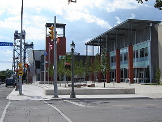
Welland is a city in the Regional Municipality of Niagara in Southern Ontario, Canada. As of 2021, it had a population of 55,750.

The Welland Canal is a ship canal in Ontario, Canada, connecting Lake Ontario and Lake Erie. It forms a key section of the St. Lawrence Seaway and Great Lakes Waterway. Traversing the Niagara Peninsula from Port Weller in St. Catharines to Port Colborne, it enables ships to ascend and descend the Niagara Escarpment and bypass Niagara Falls. It is the fourth canal connecting these waterways; three smaller predecessors also bore the same name.
The Queen Elizabeth Way (QEW) is a 400-series highway in the Canadian province of Ontario linking Toronto with the Niagara Peninsula and Buffalo, New York. The freeway begins at the Peace Bridge in Fort Erie and travels 139.1 kilometres (86.4 mi) around the western end of Lake Ontario, ending at Highway 427 in Toronto. The physical highway, however, continues as the Gardiner Expressway into downtown Toronto. The QEW is one of Ontario's busiest highways, with an average of close to 200,000 vehicles per day on some sections. Major highway junctions are at Highway 420 in Niagara Falls, Highway 405 in Niagara-on-the-Lake, Highway 406 in St. Catharines, the Red Hill Valley Parkway in Hamilton, Highway 403 and Highway 407 in Burlington, Highway 403 at the Oakville–Mississauga boundary, and Highway 427 in Etobicoke. Within the Regional Municipality of Halton the QEW is signed concurrently with Highway 403. The speed limit is 100 km/h (62 mph) throughout most of its length, with the exceptions being between Hamilton and St. Catharines where the posted limit is 110 km/h (68 mph).
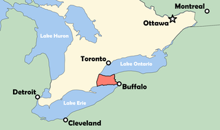
The Niagara Peninsula is an area of land lying between the southwestern shore of Lake Ontario and the northeastern shore of Lake Erie, in Ontario, Canada. Technically an isthmus rather than a peninsula, it stretches from the Niagara River in the east to Hamilton, Ontario, in the west. The peninsula is located in the Golden Horseshoe region of Southern Ontario, and has a population of roughly 1,000,000 residents. The region directly across the Niagara River and Lake Erie in New York State is known as the Niagara Frontier.

The Regional Municipality of Niagara, also colloquially known as the Niagara Region or Region of Niagara, is a regional municipality comprising twelve municipalities of Southern Ontario, Canada. The regional seat is in Thorold. It is the southern end of the Golden Horseshoe, the largest megalopolis in Canada.
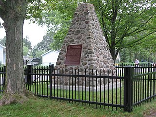
Chippawa is a community located within the city of Niagara Falls, Ontario.

Lincoln County is a historic county in the Canadian province of Ontario.

Welland County is a historic county in the Canadian province of Ontario.
King's Highway 406, commonly referred to as Highway 406, is a 400-series highway in the Canadian province of Ontario. The primary north–south route through the central portion of the Niagara Peninsula, Highway 406 connects Welland, Thorold and downtown St. Catharines to the Queen Elizabeth Way (QEW).

Glanbrook is the south-western district of the city of Hamilton, Ontario, Canada. It was first created as an independent township in 1974 through the amalgamation of Mount Hope, Binbrook, Glanford, and other nearby communities. In 2001, Glanbrook became a dissolved municipality after it was amalgamated with Hamilton, Stoney Creek, Dundas, Ancaster and Flamborough to become the present city of Hamilton.
Lincoln was a federal electoral district represented in the House of Commons of Canada from 1867 to 1883 and from 1904 to 1997. It was on the Niagara Peninsula in the Canadian province of Ontario. At various times, there was also an electoral district of the same name used in provincial elections.

St. Catharines is a federal electoral district in the Niagara Region of Ontario, Canada, that has been represented in the House of Commons of Canada since 1968.
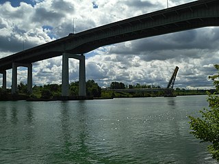
The Garden City Skyway is a major high-level bridge located in St. Catharines and Niagara-on-the-Lake, Ontario, Canada, that allows the Queen Elizabeth Way (QEW) to cross the Welland Canal without the interruption of a lift bridge. Six lanes of traffic are carried across the bridge, which is 2.2 kilometres (1.4 mi) in length and 40 metres (130 ft) at its tallest point.

Niagara Centre is a federal electoral district in the Niagara Region of Ontario that has been represented in the House of Commons of Canada from 1867 to 1988 and since 1997.
Cooks Mills is a small community in the easternmost part of the city of Welland in Ontario, Canada. It was established, and is still centred, on a Welland River tributary called Lyons Creek. It is almost entirely a bedroom community, as there are few employers located in the area.
The Lincoln and Welland Regiment is a Primary Reserve infantry regiment of the Canadian Army based in St. Catharines and Welland, Ontario.
The Diocese of Niagara is one of thirty regional divisions in the Anglican Church of Canada. The see city of the diocese is Hamilton, with the bishop's cathedra located at Christ's Church Cathedral on James Street North. Located within the ecclesiastical province of Ontario, it borders the Dioceses of Huron and Toronto. The area enclosed by the Diocese of Niagara includes much of the Golden Horseshoe, and moves north to include Erin and Orangeville as far as Shelburne. Moving sharply south the line includes Mount Forest and widens, south-westerly to include Elora and Guelph. Skirting Brantford and the Territory of the Six Nations Confederacy, the line then travels, again, south-westerly to Jarvis and Lake Erie to include the entire Niagara Peninsula. Major urban centres within its borders are St. Catharines, Niagara Falls, Hamilton, Guelph, Oakville, Milton, Burlington, and Orangeville.
Welland Transit was a public transportation agency in Welland, Ontario, Canada from 1977 to 2022. Upon its inception in 1973 the bus service was operated by a private company, known as "Metro Niagara Transit," funded by the city of Welland, which assumed full operation of the transit system in 1977. On January 1st, 2023, it was merged with St. Catharines Transit and Niagara Falls Transit to form Niagara Region Transit.
