History
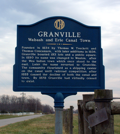
Thomas W. Treckett and Thomas Concannon founded the town in 1834 on the south side of the Wabash and Erie Canal, just south of the Wabash River near the former site of the Native American settlement of Ouiatenon. They platted the town to contain 153 lots, a public square and several streets, with such names as Lafayette, Cherry, Wabash and Washington. [1] This plat is still in effect, with the lots and streets still visible in the county's GIS. [2]

The Wabash and Erie Canal was a shipping canal that linked the Great Lakes to the Ohio River via an artificial waterway. The canal provided traders with access from the Great Lakes all the way to the Gulf of Mexico. Over 460 miles long, it was the longest canal ever built in North America.

The Wabash River is a 503-mile-long (810 km) river in Ohio and Indiana, United States, that flows from the headwaters near the middle of Ohio's western border northwest then southwest across northern Indiana turning south along the Illinois border where the southern portion forms the Indiana-Illinois border before flowing into the Ohio River. It is the largest northern tributary of the Ohio River. From the dam near Huntington, Indiana, to its terminus at the Ohio River, the Wabash flows freely for 411 miles (661 km). Its watershed drains most of Indiana. The Tippecanoe River, White River, Embarras River and Little Wabash River are major tributaries. The river's name comes from an Illini Indian word meaning "water over white stones".

Native Americans, also known as American Indians, Indigenous Americans and other terms, are the indigenous peoples of the United States, except Hawaii and territories of the United States. More than 570 federally recognized tribes live within the US, about half of which are associated with Indian reservations. The term "American Indian" excludes Native Hawaiians and some Alaskan Natives, while "Native Americans" are American Indians, plus Alaska Natives of all ethnicities. The US Census does not include Native Hawaiians or Chamorro, instead being included in the Census grouping of "Native Hawaiian and other Pacific Islander".
In 1850 the town's name was changed to Weaton, after the local Wea Indians (some maps incorrectly labeled it as "Wheaton"). They had been mostly removed west of the Mississippi River by treaties with the United States government. Later the name was changed back to Granville. The town flourished as a shipping center on the canal until the mid-1850s, when railroad competition drew off much of the business. With the decline of canal traffic, the town's economy also declined sharply. By 1878 Granville had virtually ceased to exist.

The Wea were a Miami-Illinois-speaking Native American tribe originally located in western Indiana, closely related to the Miami Tribe. The name Wea is used today as the a shortened version of their numerous recorded names. The Wea name for themselves (autonym) in their own language is waayaahtanwa, derived from waayaahtanonki, 'place of the whirlpool', where they were first recorded being seen and where they were living at that time. The different spellings of their name are numerous, as they were made by different settlers from different language and educational backgrounds. One French version is Ouiatenon; another Ouiateno; there were Wea villages, whose sites are now known as Lafayette and Terre Haute, Indiana, respectively. In 2004 the Indiana Historical Bureau installed a marker commemorating the Wea Village in Terre Haute and its living descendants. The Wea spoke a dialect of Miami, the same language as the Miami Tribe, both from the Algonquian languages.
The cemetery east of the town and the nearby bridge across the Wabash River still bear the name of Granville, though these areas are now serviced by the postal service as a part of West Point, Indiana.

West Point is an unincorporated community and census-designated place in Wayne Township, Tippecanoe County, in the U.S. state of Indiana. The population was 594 at the 2010 census.
Warren County lies in western Indiana between the Illinois state line and the Wabash River in the United States. According to the 2010 census, the population was 8,508. The county seat is Williamsport.

Fountain County lies in the western part of the U.S. state of Indiana on the east side of the Wabash River. The county was officially established in 1826 and was the 53rd in Indiana. The county seat is Covington.

Francisco is a town in Center Township, Gibson County, Indiana, United States. The population was 469 at the 2010 census. It was founded in 1851. Local tradition says the town was named for its first settler, a Spanish laborer working on the Wabash and Erie Canal who built a shack in the area. It is part of the Evansville, Indiana, Metropolitan Area.

Lafayette is a city in and the county seat of Tippecanoe County, Indiana, United States, located 63 miles (101 km) northwest of Indianapolis and 105 miles (169 km) southeast of Chicago. West Lafayette, on the other side of the Wabash River, is home to Purdue University, which contributes significantly to both communities. Together, Lafayette and West Lafayette form the core of the Lafayette, Indiana Metropolitan Statistical Area. According to the 2010 United States Census, the population of Lafayette was 67,140, roughly a 19% increase from 56,397 in 2000. Meanwhile, the 2010 U.S. Census pegged the year-round population of West Lafayette at 29,596 and the Tippecanoe County population at 172,780.

The Tippecanoe River is a gentle, 182-mile-long (293 km) river in the Central Corn Belt Plains ecoregion in northern Indiana. It flows from Big Lake in Noble County to the Wabash River near what is now Battle Ground, about 12 miles (19 km) northeast of Lafayette. The name "Tippecanoe" was derived from a Miami-Illinois word for buffalo fish, reconstructed as */kiteepihkwana/ or as kiteepihkwana siipiiwi.

Pittsburg is an unincorporated community in Tippecanoe Township, Carroll County, Indiana. It is part of the Lafayette, Indiana Metropolitan Statistical Area.

Wabash Township is one of thirteen townships in Tippecanoe County, Indiana, United States. As of the 2010 census, its population was 59,279 and it contained 21,448 housing units making it the most populous township in Tippecanoe County.

Glen Hall is a small unincorporated community in Wayne Township, Tippecanoe County, in the U.S. state of Indiana.

Ouiatenon was a dwelling place of members of the Wea tribe of Native Americans. The name Ouiatenon, also variously given as Ouiatanon, Oujatanon, Ouiatano or other similar forms, is a French rendering of a term from the Wea dialect of the Miami-Illinois language which means "place of the people of the whirlpool", an ethnonym for the Wea. Ouiatenon can be said to refer generally to any settlement of Wea or to their tribal lands as a whole, though the name is most frequently used to refer to a group of extinct settlements situated together along the Wabash River in what is now western Tippecanoe County, Indiana.

Liberty Mills is an unincorporated community on the Eel River in Chester Township, Wabash County, in the U.S. state of Indiana. Proprietor John Comstock (1802–1879) platted the town June 24, 1837. The name Liberty Mills comes from the number of mills the town once operated, including a saw mill, a carding mill, and a distillery, with one of the mills coming from the ‘Liberty’ brand. Its ZIP code is 46946.
Prairie Township is one of twelve townships in White County, Indiana, United States. As of the 2010 census, its population was 3,180 and it contained 1,311 housing units.

Round Grove Township is one of twelve townships in White County, Indiana, United States. As of the 2010 census, its population was 259 and it contained 103 housing units.

Shelby Township is one of thirteen townships in Tippecanoe County, Indiana, United States. As of the 2010 census, its population was 2,352 and it contained 920 housing units.

Union Township is one of thirteen townships in Tippecanoe County, Indiana, United States. As of the 2010 census, its population was 1,610 and it contained 675 housing units.

Downtown Lafayette Historic District is a national historic district located at Lafayette, Tippecanoe County, Indiana. Lafayette began in 1825 as a transportation center for the west central area of Indiana. Its development and growth reflects the changes in transportation over the intervening years. From its location along the Wabash River, it grew first with river travel then for a short while from the Wabash and Erie Canal. When the railroads arrived in the 1850s, the town began to grow, initially along the rail lines. The Downtown Lafayette Historic District reflects these early changes.
LaGrange was a small town, now extinct, in Shelby Township, Tippecanoe County, in the U.S. state of Indiana.