
Mount Anderson is a 7,330-foot-high (2,234 m) peak in the Olympic Mountains of the Pacific Northwest. Rising in the center of Olympic National Park in Washington state, it is the second highest peak on the Anderson Massif, after West Peak. Anderson Glacier used to be located in a cirque on the mountain's southern flank while Eel Glacier is in another cirque, northwest of the summit. Hanging Glacier is on the east side of a ridge which extends north from the peak.

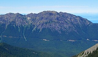
Mount Constance is a peak in the Olympic Mountains of Washington and the third highest in the range. It is the most visually prominent peak on Seattle's western skyline. Despite being almost as tall as the ice-clad Mount Olympus to the west, Mount Constance has little in the way of glaciers and permanent snow because the eastern, and particularly this northeastern, portion of the Olympics receives far less precipitation. However the narrow and steep Crystal Glacier still exists on the mountain's north face, shaded by the bulk of the main peak and with a small lake at its terminus. In addition, the treeline is higher here than mountains to the west, also hinting at the drier alpine conditions.

Mount Deception is a peak in the Olympic Mountains of Cascadia. It is in Olympic National Park on the Olympic Peninsula in the U.S. state of Washington.

Mount Angeles is located just south of Port Angeles, Washington in the Olympic National Park. It is the highest peak in the Hurricane Ridge area. The summit, which offers panoramic views of the Strait of Juan de Fuca and many of the peaks of the interior Olympic Mountains can be climbed from the Klahane Ridge trail.

Mount Townsend is a mountain in the U.S state of Washington located within the Buckhorn Wilderness near Quilcene.

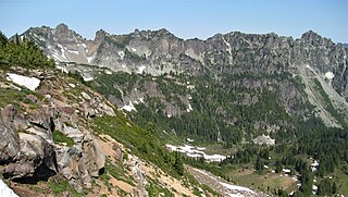
Chikamin Peak is a 7,000+ ft mountain summit located in the cascade Range, in Kittitas County of Washington state. It is situated within the Alpine Lakes Wilderness, on land managed by the Okanogan–Wenatchee National Forest. The mountain's name "Chikamin" derives from Chinook Jargon meaning "money" or "metal", and was submitted by Edmond S. Meany, president of The Mountaineers. This name was officially adopted in 1916 by the U.S. Board on Geographic Names. Chikamin Peak is the highest point of Chikamin Ridge, 6 mi (9.7 km) northeast of Snoqualmie Pass. Other notable peaks on Chikamin Ridge include Four Brothers and Three Queens. Precipitation runoff from this mountain drains into tributaries of the Yakima River. The Pacific Crest Trail traverses the southwest slope of Chikamin Ridge, and from the trail a scramble up a gully leads to the summit and several alpine lakes including Chikamin Lake and Spectacle Lake.
Rocky Peak is a 6,218 feet (1,895 m) summit in the Olympic Mountains and is located in Clallam County of Washington state. It is situated eight miles south of Port Angeles, Washington within Olympic National Park. Its nearest higher peak is Mount Angeles, 1.87 mi (3.01 km) to the west. Klahhane Ridge connects these two peaks. Travelers on the scenic Hurricane Ridge Road traverse the lower south slope of Rocky Peak en route to the Hurricane Ridge visitor center. The mountain was named Rocky Peak by local people from the time of the earliest settlers in the area. Precipitation runoff from the north side of the peak drains into Rocky Creek, whereas the south slope drains into Morse Creek, thence into the Strait of Juan de Fuca.

Mount Fricaba is a 7,139-foot-elevation (2,176 m) double summit mountain located in the Olympic Mountains, in Jefferson County of Washington state. It is situated on the shared border of Olympic National Park with Buckhorn Wilderness, and is the highest point in that wilderness, as well as the Olympic National Forest. Its nearest higher peak is Hal Foss Peak, 0.74 miles (1.19 km) to the southwest. Precipitation runoff from the peak drains east into headwaters of the Dungeness River, or west into Deception Creek which is a tributary of the Dosewallips River. The mountain's name was officially adopted in 1961 by the United States Board on Geographic Names based on usage by The Mountaineers since 1907, and inclusion in Fred Beckey's "Climber's Guide to the Cascade and Olympic Mountains of Washington" published in 1949. The first ascent of the mountain was made in 1957 by Don Bechlem and Jack Newman.

Mount Walkinshaw is a 7,378 feet (2,249 m) mountain summit located in the Olympic Mountains, in Jefferson County of Washington state. It is situated within Olympic National Park, and is the northernmost peak in The Needles range, which is a subset of the Olympic range. Its nearest higher peak is Mount Clark, 0.9 mi (1.4 km) to the south, and Gray Wolf Ridge arcs to the northeast. Mount Walkinshaw is set in the eastern portion of the Olympic Mountains within the drainage basin of the Dungeness River. This position puts it in the rain shadow of the Olympic Range, resulting in less precipitation than Mount Olympus and the western Olympics receive.

Boulder Ridge is a 6,852-foot (2,088-metre) elevation mountain ridge located in the eastern Olympic Mountains in Jefferson County of Washington state. It is set within Buckhorn Wilderness on land managed by the Olympic National Forest. Its nearest higher peak is Alphabet Ridge, 0.94 mi (1.51 km) to the south, and Buckhorn Mountain rises 1.3 mi (2.1 km) to the north. Precipitation runoff from Boulder Ridge drains east into headwaters of the Big Quilcene River, west into tributaries of Dungeness River, and south into Charlia Lakes, thence Tunnel Creek.

Mount Cruiser is a 6,104-foot-elevation mountain summit located in the Olympic Mountains, in Mason County of Washington state. It is situated in Mount Skokomish Wilderness on land managed by Olympic National Forest. Cruiser is the highest point on Sawtooth Ridge, and its nearest higher peak is Mount Skokomish, 2.1 mi (3.4 km) to the north-northeast. Cruiser has two sub-peaks, Alpha, and Beta, the latter of which lies on the Olympic National Park boundary. The first ascent of the peak was made in 1937 by Paul Crews and Ray Layton. The mountain was named by the first ascent party to recognize their club, the Bremerton Ski Cruisers. The mountain's name was officially adopted in 1961 by the United States Board on Geographic Names. Precipitation runoff from the mountain drains into the Hamma Hamma River.
Mount Pulitzer, also known as Snagtooth, is a 6,283-foot (1,915-metre) mountain summit located within Olympic National Park in Jefferson County of Washington state. Mount Pulitzer is the sixth-highest peak in the Bailey Range, which is a subrange of the Olympic Mountains. Its nearest neighbor is Mount Ferry, 0.58 mi (0.93 km) to the northeast, and its nearest higher neighbor is Stephen Peak, 2.58 mi (4.15 km) to the north. Mount Olympus is set 6.8 mi (10.9 km) to the southwest. In clear weather, the mountain can be seen from the visitor center at Hurricane Ridge. Precipitation runoff from the mountain drains into tributaries of the Elwha and Hoh Rivers. The first ascent of the summit was made in 1961 by Doug Waali, Bob Wood, and Kent Heathershaw via the east ridge.

Ruth Peak is a 6,850+ ft glaciated mountain summit located within Olympic National Park in Clallam County of Washington state. Ruth Peak is the third-highest peak in the Bailey Range, which is a subrange of the Olympic Mountains. Its nearest higher neighbor is Mount Carrie, 0.91 mi (1.46 km) to the northwest, and Mount Fairchild is set 0.92 mi (1.48 km) to the north. In clear weather, the mountain can be seen from the visitor center at Hurricane Ridge. Precipitation runoff from the mountain drains into tributaries of the Hoh and Elwha Rivers. The first ascent of this peak was made in 1961 by Bert Brown, Roy Etten, and Victor Nelson.

Martin Peak is a mountain summit in the Olympic Mountains and is located in Jefferson County of Washington state. It is located within Olympic National Park. At 7,638 feet (2,328 m) high, Martin Peak is the seventh-highest peak of the Olympic Mountains, and the second-highest peak in The Needles range, which is a subset of the Olympic range. Its nearest higher neighbor is Mount Johnson, 0.53 mi (0.85 km) to the north-northwest. Precipitation runoff from this peak drains west into headwaters of Gray Wolf River, or east into Royal Creek, both of which are part of the Dungeness River drainage basin. Martin Peak was given its name based on the first ascent in 1940 by George W. Martin (1901–1970), and Elvin Johnson.
Mother Mountain is a 6,480+ ft multi-summit, 3-mile long ridge-like mountain located in Mount Rainier National Park, in Pierce County of Washington state. It is part of the Cascade Range, and lies 7 mi (11 km) northwest of the summit of Mount Rainier. The Wonderland Trail provides one approach option to this mountain, and the summit offers views of Mount Rainier. East Fay Peak is its nearest higher neighbor, 0.42 mi (0.68 km) to the south. Precipitation runoff from Mother Mountain is drained by Cataract Creek on the south side of the mountain, and Ipsut Creek drains the north side of it, and both are tributaries of the Carbon River. The west side drains into Mowich Lake, and thence Mowich River.

Mount Lincoln is a 5,868-foot-elevation mountain summit located in the Olympic Mountains, in Mason County of Washington state. It is situated on the boundary shared by Daniel J. Evans Wilderness and Mount Skokomish Wilderness, as well as the shared common border of Olympic National Park with Olympic National Forest. Lincoln is the second-highest point on Sawtooth Ridge, and the nearest higher neighbor is Mount Cruiser, 1.1 mi (1.8 km) to the northeast. Lincoln has two sub-peaks: a North Peak (5,690 ft/1,734 m), and a Southwest Peak (5,486 ft/1,672 m). Flapjack Lakes lie immediately west below the north sub-peak. Topographic relief is significant as the summit rises over 5,100 feet (1,555 m) above the Staircase Ranger Station at Lake Cushman in approximately two miles. Precipitation runoff from the mountain drains into tributaries of the North Fork Skokomish River, and partly into Mildred Lakes, thence Hamma Hamma River.
The Bailey Range is a mountain range located within Olympic National Park in Washington state.

Tyler Peak is a 6,364 feet (1,940 m) mountain summit located in Clallam County of Washington state. It is situated in the northeastern Olympic Mountains, near the northern end of Gray Wolf Ridge, and is set within Buckhorn Wilderness, on land managed by the Olympic National Forest. The next highest neighbor is Mt. Baldy, two miles to the west.

The Needles is a mountain ridge located within Olympic National Park in Jefferson County of Washington state.

Iron Mountain is a 6,826-foot (2,081-metre) elevation summit located in the eastern Olympic Mountains in Jefferson County of Washington state. It is set within Buckhorn Wilderness, on land managed by Olympic National Forest. It is situated between Buckhorn Mountain, 0.58 mi (0.93 km) to the southwest, and Mount Worthington, 0.76 mi (1.22 km) to the northeast. Precipitation runoff from Iron Mountain drains south into the Big Quilcene River, and north into Copper Creek which is a tributary of the Dungeness River. Topographic relief is significant as the southeast aspect rises 2,800 feet above the Big Quilcene River in less than one mile, and the north aspect rises 1,700 feet above Buckhorn Lake in one-half mile. Old-growth forests of Douglas fir, western hemlock, and western redcedar grow in the valleys surrounding the peak. The nearest community is Quilcene 11 miles to the east.


