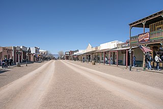
Tombstone is a city in Cochise County, Arizona, United States, founded in 1879 by prospector Ed Schieffelin in what was then Pima County, Arizona Territory. It became one of the last boomtowns in the American frontier. The town grew significantly into the mid-1880s as the local mines produced $40 to $85 million in silver bullion, the largest productive silver district in Arizona. Its population grew from 100 to around 14,000 in less than seven years. It is best known as the site of the Gunfight at the O.K. Corral and presently draws most of its revenue from tourism.
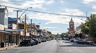
Broken Hill is a city in the far west region of outback New South Wales, Australia. An inland mining city, is near the border with South Australia on the crossing of the Barrier Highway (A32) and the Silver City Highway (B79), in the Barrier Range. It is 315m above sea level, with a hot desert climate, and an average rainfall of 235mm. The closest major city is Mildura, 300 km to the south and the nearest State Capital City is Adelaide, the capital of South Australia, which is more than 500 km to the southwest and linked via route A32.

Bodie is a ghost town in the Bodie Hills east of the Sierra Nevada mountain range in Mono County, California, United States. It is about 75 miles (121 km) southeast of Lake Tahoe, and 12 mi (19 km) east-southeast of Bridgeport, at an elevation of 8,379 feet (2554 m). Bodie became a boom town in 1876 after the discovery of a profitable vein of gold; by 1879 it had established 2,000 structures with a population of roughly 8,000 people.

Virginia City is a census-designated place (CDP) that is the county seat of Storey County, Nevada, and the largest community in the county. The city is a part of the Reno–Sparks Metropolitan Statistical Area.

The Comstock Lode is a lode of silver ore located under the eastern slope of Mount Davidson, a peak in the Virginia Range in Virginia City, Nevada, which was the first major discovery of silver ore in the United States and named after American miner Henry Comstock.

Kennecott, also known as Kennicott and Kennecott Mines, is an abandoned mining camp in the Copper River Census Area in the U.S. state of Alaska that was the center of activity for several copper mines. It is located beside the Kennicott Glacier, northeast of Valdez, inside Wrangell-St. Elias National Park and Preserve. The camp and mines are now a National Historic Landmark District administered by the National Park Service.

State Route 49 is a north–south state highway in the U.S. state of California that passes through many historic mining communities of the 1849 California gold rush and it is known as the Golden Chain Highway. The highway's creation was lobbied by the Mother Lode Highway Association, a group of locals and historians seeking a single highway to connect many relevant locations along the Gold Rush to honor the 49ers. One of the bridges along SR 49 is named for the leader of the association, Archie Stevenot.

The Quincy Mine is an extensive set of copper mines located near Hancock, Michigan. The mine was owned by the Quincy Mining Company and operated between 1846 and 1945, although some activities continued through the 1970s. The Quincy Mine was known as "Old Reliable," as the Quincy Mine Company paid a dividend to investors every year from 1868 through 1920. The Quincy Mining Company Historic District is a United States National Historic Landmark District; other Quincy Mine properties nearby, including the Quincy Mining Company Stamp Mills, the Quincy Dredge Number Two, and the Quincy Smelter are also historically significant.

Empire Mine State Historic Park is a state-protected mine and park in the Sierra Nevada mountains in Grass Valley, California, U.S. The Empire Mine is on the National Register of Historic Places, a federal Historic District, and a California Historical Landmark. Since 1975 California State Parks has administered and maintained the mine as a historic site. The Empire Mine is "one of the oldest, largest, deepest, longest and richest gold mines in California". Between 1850 and its closure in 1956, the Empire Mine produced 5.8 million ounces of gold, extracted from 367 miles (591 km) of underground passages.
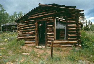
Hamilton City, or Miner's Delight as it was commonly known, was a town in Fremont County, Wyoming, United States, on the southeastern tip of the Wind River Range, that prospered during the mining boom in the American West in the second half of the 19th century. It was a "sister city" of Atlantic City and South Pass City. Today a few buildings still stand as a reminder of an era in Wyoming's past history.
The Marlette Lake Water System was created to provide water for the silver mining boom in Virginia City, Nevada. These structures are now listed as a National Historic Civil Engineering Landmark by the American Society of Civil Engineers, and are also listed on the National Register of Historic Places. The listed area included two contributing buildings and 12 contributing structures on 135.4 acres (54.8 ha). It has also been known historically as the Virginia and Gold Hill Water Company Water System.

The Central City/Black Hawk Historic District is a National Historic Landmark District that encompasses the developed areas of Central City and Black Hawk, Colorado, United States. They are adjacent former gold mining camps in the Front Range of the Rocky Mountains in Gilpin County, Colorado. For a time, the area was known as the Richest Square Mile on Earth, and was the largest urban area of the Colorado Territory in the 1870s.

The Georgetown–Silver Plume National Historic Landmark District is a federally designated United States National Historic Landmark that comprises the Town of Georgetown, the Town of Silver Plume, and the Georgetown Loop Historic Mining & Railroad Park between the two silver mining towns along Clear Creek in the Front Range of the Rocky Mountains in Clear Creek County, Colorado, United States.

The Jerome Historic District is a National Historic Landmark District encompassing the former mining community of Jerome, Arizona. The town was founded as a mining camp associated with copper deposits that were mined from the late 19th century until 1953. The district was declared a National Historic Landmark in 1966 and was included into the then-new National Register of Historic Places.
Gold mining in Alaska, a state of the United States, has been a major industry and impetus for exploration and settlement since a few years after the United States acquired the territory in 1867 from the Russian Empire. Russian explorers discovered placer gold in the Kenai River in 1848, but no gold was produced. Gold mining started in 1870 from placers southeast of Juneau, Alaska.

The Bremner Historic Mining District is a historic district in Wrangell-St. Elias National Park and Preserve in Alaska. It is named after John Bremner, who in 1884-1885 was the first non-native person to live in the area and who prospected for gold along the Bremner River. Located just to the north of the Bremner River, it was the scene of an important placer gold discovery in 1902, and played a key role in the history of the Copper River Basin. Only a few miners struck it rich, but the resulting demand for materials and supplies helped establish regional transportation networks, encouraged supporting industries, and hastened the exploration and settlement of the entire region. While small-scale placer mining continued for over forty years, lode development was largely confined to the period between 1934 and 1941, the district's most significant era.

The Calumet Historic District is a National Historic Landmark District that encompasses most of the village of Calumet, Michigan. The district was designated in 1989 for the community's importance in the history of the region's copper mining industry.
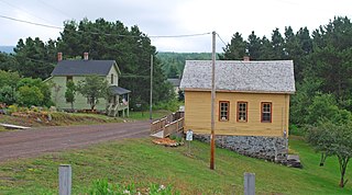
The Central Mine Historic District is a historic district located off US 41 in Upper Michigan. The mine itself was designated a Michigan State Historic Site in 1958, while the surrounding district was designated a Michigan State Historic Site in 1973 and listed on the National Register of Historic Places in 1974.

Highland Park, also known as Highland Pines, is a populated place situated near Prescott and within the Prescott National Forest, in Yavapai County, Arizona, United States. Highland Pines is the promotional name associated with the Highland Park areas several subdivisions. In the Arizona Territorial era up to 1912, and Statehood until around the late 1920s, this particular area of land acted as a cattle ranch with a mining history, lies within the Thumb Butte Mining District, which appears to be initially platted by the Arizona Corporation Highland Pine Properties Inc. beginning in the late 1950s.


