Great Somerford

Last updated

Great Somerford
The Volunteer Inn, Great Somerford - geograph.org.uk - 1384215.jpg
The Volunteer Inn, Great Somerford
Wiltshire UK location map.svg
Red pog.svg
Great Somerford
Location within Wiltshire
Population737 (in 2011) [1]
OS grid reference ST964827
Unitary authority
Ceremonial county
Region
Country England
Sovereign state United Kingdom
Post town CHIPPENHAM
Postcode district SN15
Dialling code 01249
Police Wiltshire
Fire Dorset and Wiltshire
Ambulance South Western
UK Parliament
Website Parish council
List of places
UK
England
Wiltshire
51°32′35″N2°03′14″W / 51.543°N 2.054°W / 51.543; -2.054 Coordinates: 51°32′35″N2°03′14″W / 51.543°N 2.054°W / 51.543; -2.054

Great Somerford is a village and civil parish within Dauntsey Vale, Wiltshire, England, [2] near the south bank of the river Avon. It lies approximately 3+14 miles (5.2 km) southeast of Malmesbury and 12 miles (19 km) west of Swindon. The hamlet of Startley and the location of Seagry Heath are within the bounds of the parish. [3] [4]

Contents

The parish boundaries to the northeast and east follow the Avon, or in some places the river's former course. In the northwest the boundary partly follows the Rodbourne stream, a small tributary which joins the Avon northwest of the village. [5] The Brinkworth Brook joins the Avon in the northwest corner of the parish.

History

Eight estates were recorded in the 1086 Domesday Book at the Somerfords, with altogether 80 households. [6] The mound of a motte castle, 40 metres in diameter and probably from the 12th century, stands immediately east of the church. [7] South of the mound is the Mount House, a 16th-century manor house, refronted in the 19th and now Grade II* listed. [8]

In 1377 there were 92 poll-tax payers at Great Somerford and 10 at Startley. [5] The population of the parish grew from 358 at the 1801 census to 481 in 1821, then remained in the range 500-556 until 1911, falling to 421 in 1921. Housebuilding in the 1960s and 1980s brought numbers above 700. [1]

Allotment gardens

Great Somerford has Britain's first allotments. Enclosure of common land, facilitated by the Inclosure Act 1773, greatly reduced the amount of land available for personal cultivation by the poor. Stephen Demainbray, rector 1799–1854 and a Chaplain to King George III, asked the King to spare part of his parish from the enclosures of 1809. A field of about 6 acres (2.4 ha) in the south of the village on Dauntsey Road became the Free Gardens, in exchange for pieces of common land elsewhere; there was a second site of about 2 acres at Seagry Heath. Plots were allotted to villages for one-year terms. [5] [9]

The Free Gardens continue in use; the Seagry Heath site reverted to private ownership. [10] The 200th anniversary in 2009 was marked by an edition of the BBC Radio 4 programme, Gardeners' Question Time . [11]

Railway

The Malmesbury Branch Line was opened across the parish in 1877, leaving the Great Western Main Line at Dauntsey and crossing the Avon just north of Great Somerford village. A station, at first named Somerford, was just east of the river crossing. [5]

The name of the station was changed to Great Somerford in 1903 when the GWR opened a more direct route to South Wales, passing half a mile (900 metres) to the north near Little Somerford, where a new station was built. In 1922 the goods yard at Great Somerford was closed and the station was downgraded to Great Somerford Halt. In 1933, Little Somerford station was linked to the Malmesbury branch and became the junction station. The line south to Dauntsey, along with the halt, was closed in July of that year. [12]

Religious sites

Parish church

Parish Church St. Peter and St. Paul Church, Great Somerford - geograph.org.uk - 103494.jpg
Parish Church

There was a church at Great Somerford in the late 12th century. [5] The present Church of England parish church of St Peter and St Paul is built of rubble stone and is from the 14th and 15th centuries, with restoration in 1865 by J.H. Hakewill. Decoration of the chancel roof in 1901 to designs of F.C. Eden was described by Pevsner as "extremely prettily painted with stylized flowers". [13] The south porch was rebuilt in 1905 using old materials. [14] [15]

The tower carries six bells: one of c. 1480 and another of 1634. [16] The ashlar gate piers, with stone urns, at the entrance to the churchyard are 18th century. [17]

The church was designated as Grade I listed in 1959. [14] Today the parish forms part of the Woodbridge Group of six churches. [18]

Methodists

Primitive Methodists were meeting at Startley by 1843, and in 1850–51 an average congregation of 90 attended Sunday services. A chapel was built in 1854, just south of the junction with Heath Lane, and was extended in 1860. The chapel closed in 1985 and is now a private house; the small cemetery on the opposite side of the road remains. [19] [20]

At Great Somerford, Methodists bought the red brick village reading room in 1882 for use as a chapel. (The reading room had been built in 1872 at the expense of Wiltshire MP Walter Powell and was sold following his death.) [21] In 2016 the building was still in use as a Methodist church within the North Wiltshire circuit, holding fortnightly services which alternate with the church at Cleverton. [22] [23]

Governance

The civil parish elects a parish council. It is in the area of Wiltshire Council unitary authority, which is responsible for most significant local government functions. The current Wiltshire councillor for the Brinkworth ward (which includes Great Somerford) is Toby Sturgis, a councillor for the Conservative Party. [24] The parish is also part of the North Wiltshire parliamentary constituency, which is, as of May 2017, represented by James Gray, also a member of the Conservative party. [25]

Amenities

The first purpose-built school at Great Somerford was built in 1828, then enlarged in 1850, 1870 and 1895. Children of all ages attended until 1954, when those aged 11 and over went to Malmesbury secondary school. In 1982, Somerfords' Walter Powell Primary School was built on a new site to the east of the village, to replace the 19th-century school and that at Little Somerford. [26]

Great Somerford has a shop with Post Office. There is also a pub, the Volunteer Inn, a building from the early 19th century. [27]

Landmarks

Great Somerford Measuring Station

In 1963 the Environment Agency constructed a river level measuring station consisting of one of the earliest compound crump weirs in Britain. [28] The typical river level range is between 15 and 70 centimetres; the highest level recorded was 2.43 metres. [29] During the widespread flooding in 2007, the river level reached 2.06 metres on 21 July, whilst flooding in July 1968 drowned the entire structure.

World War II pillboxes

There are three remaining Second World War pillboxes in the village. The first faces the river and the disused railway. The second is on the edge of a medium-sized field next to the Avon; there has been no damage to this pillbox, though in heavy rain it tends to flood. The third pillbox is along the left of Dauntsey Road, opposite a small cottage.

Related Research Articles

Sherston, Wiltshire Human settlement in England

Sherston is a village and civil parish about 5 miles (8 km) west of Malmesbury in Wiltshire, England. The parish is bounded to the north by the county boundary with Gloucestershire, and to the southeast by the Fosse Way, a Roman road. The parish includes the hamlets of Easton Town, immediately east of Sherston; Pinkney, further east along the Malmesbury road; and Willesley, to the north.

Grafton, Wiltshire Human settlement in England

Grafton is a civil parish in Wiltshire, England, in the Vale of Pewsey about 7 miles (11 km) southeast of Marlborough. Its main settlement is the village of East Grafton, on the A338 Burbage - Hungerford road; the parish includes the village of Wilton and the hamlets of West Grafton, Marten and Wexcombe.

Purton Village in England

Purton is a large village and civil parish in Wiltshire, England, about 4 miles (6 km) northwest of the centre of Swindon. The parish includes the village of Purton Stoke and the hamlets of Bentham, Hayes Knoll, Purton Common, Restrop, The Fox and Widham. The River Key, a tributary of the Thames, crosses the parish near Purton Stoke.

Box, Wiltshire Village in the Cotswolds, England

Box is a large village and civil parish within the Cotswolds Area of Outstanding Natural Beauty in Wiltshire, England, about 3 miles (5 km) west of Corsham and 5 miles (8 km) northeast of Bath. Box also falls in the easternmost part of the Avon Green Belt. Besides the village of Box, the parish includes the villages of Ashley and Box Hill; Hazelbury manor; and the hamlets of Alcombe, Blue Vein, Chapel Plaister, Ditteridge, Henley, Kingsdown, Middlehill, and Wadswick. To the east the parish includes much of Rudloe, formerly a hamlet but now a housing estate, and the defence establishments and related businesses on the site of RAF Rudloe Manor.

West Lavington, Wiltshire Human settlement in England

West Lavington is a village and civil parish in Wiltshire, England, on the north edge of Salisbury Plain, on the A360 road between Devizes and Salisbury, about 5 miles (8 km) south of Devizes. The parish includes the hamlet of Littleton Panell.

Brinkworth, Wiltshire Human settlement in England

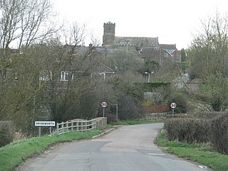
Brinkworth is a village and civil parish in northern Wiltshire, England. The village lies between Royal Wootton Bassett and Malmesbury, about 1 mile (1.6 km) north of the M4 motorway and 9 miles (14 km) west of Swindon.

Lea, Wiltshire Human settlement in England

Lea is a village in Wiltshire, England, lying approximately 1.5 miles (2.4 km) east of Malmesbury. It is part of the civil parish of Lea and Cleverton which includes the village of Garsdon and the hamlet of Cleverton. Garsdon was a separate parish until 1934.

Christian Malford Human settlement in England

Christian Malford is a village and civil parish in the county of Wiltshire, England. The village lies about 4+12 miles (7 km) northeast of the town of Chippenham. The Bristol Avon forms most of the northern and eastern boundaries of the parish. The hamlets of Thornend and Upper Town lie within the parish.

Sutton Benger Human settlement in England

Sutton Benger is a village and civil parish in the county of Wiltshire, England, 5 miles (8.0 km) northeast of the town of Chippenham. The parish includes the hamlet of Draycot Cerne.

Dauntsey Human settlement in England

Dauntsey is a small village and civil parish in the county of Wiltshire, England. It gives its name to the Dauntsey Vale in which it lies and takes its name from Saxon for Dantes- eig, or Dante's island. It is set on slightly higher ground in the flood plain of the upper Bristol Avon.

Corston, Wiltshire Human settlement in England

Corston is a small village on the A429 road in Wiltshire, England, in the civil parish of St Paul Malmesbury Without, approximately 3 miles (4.8 km) south of the town of Malmesbury. The Gauze Brook, a tributary of the Bristol Avon, passes through the village.

Winterbourne Dauntsey Human settlement in England

Winterbourne Dauntsey is a village in Wiltshire, England, in the Bourne valley on the A338 road about 3.5 miles (6 km) northeast of Salisbury.

Seagry Human settlement in England

Seagry is a civil parish in Wiltshire, England, about 4.5 miles (7.2 km) southeast of Malmesbury and 5.5 miles (8.9 km) northeast of Chippenham. Its main settlements are the village of Upper Seagry, which was first mentioned in official records under the name Over Seagry, and the hamlet of Lower Seagry, which was first documented (1218) as Nether Seagry.

Malmesbury Human settlement in England

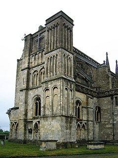
Malmesbury is a town and civil parish in Wiltshire, England. As a market town it became prominent in the Middle Ages as a centre for learning focused on and around Malmesbury Abbey, the bulk of which forms a rare survival of the dissolution of the monasteries. Once the site of an Iron Age fort, in the Anglo-Saxon period it became the site of a monastery famed for its learning and one of Alfred the Great's fortified burhs for defence against the Vikings. Æthelstan, the first king of all England, was buried in Malmesbury Abbey when he died in 939.

Malmesbury was a hundred of the English county of Wiltshire, lying in the north of the county and centring on the historic borough and market town of Malmesbury. The hundred of Malmesbury represents parishes that were within the Domesday hundreds of Chedglow and Startley, which were held at farm by the Abbot of Malmesbury.

Little Somerford Human settlement in England

Little Somerford is a village and civil parish in Wiltshire, England, 3 miles (4.8 km) southeast of Malmesbury and 7.5 miles (12.1 km) northeast of Chippenham.

Rodbourne, St Paul Malmesbury Without

Rodbourne is a small village in Wiltshire, England, in the civil parish of St Paul Malmesbury Without about 2.5 miles (4.0 km) south of the town of Malmesbury. The hamlet of Rodbourne Bottom is 0.5 miles (0.80 km) south of the village.

Great Somerford Halt railway station

Great Somerford Halt was a station on the Malmesbury Branch Line of the Great Western Railway in Wiltshire, England. It was open from 1877 to 1933 for passengers, and 1879 to 1922 for goods.

Little Somerford railway station Disused railway station in Little Somerford, Wiltshire

Little Somerford railway station served the village of Little Somerford, Wiltshire, England from 1903 to 1962. It was on the South Wales Main Line and served as the junction for the Malmesbury branch line from 1933.

References

  1. 1 2 "Wiltshire Community History – Census". Wiltshire Council. Retrieved 5 February 2015.
  2. OS Explorer Map 156, Chippenham and Bradford-on-Avon, Scale: 1:25 000. Publisher: Ordnance Survey A2 edition (2007). ISBN   978-0319239438
  3. "Wiltshire Community History: Great Somerford". Wiltshire Council. Retrieved 27 February 2014.
  4. "Wiltshire Community History: Map of Great Somerford". Wiltshire Council. Retrieved 27 February 2014.
  5. 1 2 3 4 5 Baggs, A.P.; Freeman, Jane; Stevenson, Janet H, eds. (1991). "Victoria County History: Wiltshire: Vol 14 pp194-204 – Parishes: Great Somerford". British History Online. University of London. Retrieved 20 December 2016.
  6. Great and Little Somerford in the Domesday Book
  7. Historic England. "Motte castle 20m west of Great Somerford Church (1013224)". National Heritage List for England . Retrieved 22 December 2016.
  8. Historic England. "The Mount House (1022515)". National Heritage List for England. Retrieved 22 December 2016.
  9. Savill, Richard (10 March 2009). "England's oldest allotments celebrate 200 years". The Daily Telegraph. Retrieved 24 December 2016.
  10. Bavister, Roy; O'Donnell, Bryan (31 October 2005). "Some notes on Great Somerford boundaries and Conservation Areas" (PDF). North Wiltshire District Council. pp. 2–3. Retrieved 24 December 2016.
  11. Ware, Joe (19 March 2009). "Radio 4 Gardeners' Question Time at Malmesbury School". Gazette & Herald. Retrieved 24 December 2016.
  12. Oakley, Mike (2004). Wiltshire Railway Stations. Wimborne: The Dovecote Press. pp. 61–62. ISBN   1904349331.
  13. Pevsner, Nikolaus; Cherry, Bridget (revision) (1975) [1963]. Wiltshire. The Buildings of England (2nd ed.). Harmondsworth: Penguin Books. p. 260. ISBN   0-14-0710-26-4.
  14. 1 2 Historic England. "Church of St Peter and Paul (1022516)". National Heritage List for England. Retrieved 20 December 2016.
  15. "Church of St. Peter and St. Paul, Great Somerford". Wiltshire Community History. Wiltshire Council. Retrieved 20 December 2016.
  16. "Great Somerford". Dove's Guide for Church Bell Ringers. Retrieved 20 December 2016.
  17. Historic England. "Gate piers at entry to churchyard (1022517)". National Heritage List for England. Retrieved 20 December 2016.
  18. "St Peter & St Paul, Great Somerford". Woodbridge Group of Churches. Retrieved 20 December 2016.
  19. "Primitive Methodist Chapel, Startley, Great Somerford". Wiltshire Community History. Wiltshire Council. Retrieved 21 December 2016.
  20. "Startley Primitive Methodist chapel". My Primitive Methodist Ancestors. Retrieved 21 December 2016.
  21. "Walter Powell MP Balloonist". Malmesbury Memories. David Forward.
  22. "Primitive Methodist Chapel, Great Somerford". Wiltshire Community History. Wiltshire Council. Retrieved 21 December 2016.
  23. "Trinity (Cleverton & Great Somerford)". North Wiltshire Methodist Circuit. Archived from the original on 22 December 2016. Retrieved 21 December 2016.
  24. "wiltshire Council". Wiltshire Council. Retrieved 3 May 2017.
  25. "James Gray's Website". James Gray's Website. Retrieved 3 May 2017.
  26. "Somerfords Walter Powell Church of England VA Primary School". Wiltshire Community History. Wiltshire Council. Retrieved 21 December 2016.
  27. Historic England. "The Volunteer Inn (1022512)". National Heritage List for England. Retrieved 24 December 2016.
  28. "53008 – Avon at Great Somerford". National River Flow Archive. Retrieved 24 December 2016.
  29. "Great Somerford". Shoothill GaugeMap. Retrieved 24 December 2016.