Greeleyville, South Carolina

Last updated

Greeleyville, South Carolina
Greeleyville, SC.jpg
Downtown Greeleyville, SC
Greeleyville SC Town Seal.png
SCMap-doton-Greeleyville.PNG
Location of Greeleyville, South Carolina
Coordinates: 33°34′53″N79°59′22″W / 33.58139°N 79.98944°W / 33.58139; -79.98944
Country United States
State South Carolina
County Williamsburg
IncorporatedDecember 20, 1893 (1893-12-20)
Government
   Mayor Jessie Parker
Area
[1]
  Total1.22 sq mi (3.17 km2)
  Land1.22 sq mi (3.17 km2)
  Water0.00 sq mi (0.00 km2)
Elevation
79 ft (24 m)
Population
 (2020) [2]
  Total384
  Density313.98/sq mi (121.18/km2)
Time zone UTC-5 (Eastern (EST))
  Summer (DST) UTC-4 (EDT)
ZIP code
29056
Area code(s) 843, 854
FIPS code 45-30535 [3]
GNIS feature ID1245822 [4]
Website townofgreeleyville.com

Greeleyville is a town in Williamsburg County, South Carolina, United States. The population was 438 at the 2010 census. The town was originally chartered on December 20, 1893. Greeleyville's seal and flag feature a depiction of the first Town Hall, which was built in the 1890s, as well as two arms, one black and one white, holding a tobacco leaf and a cotton boll. [5] These symbols represent the unity and cooperation among all the people of Greeleyville and pay tribute to the town's agricultural heritage. [5]

Contents

Since 1982, the town has hosted an annual Flag Day celebration each Memorial Day weekend that features bingo, street dances, barbecue, as well as various other types of vendors. [6] [7]

History

The area surrounding Greeleyville was once home to several Native American tribes, including the Wee Nee, Wee Tee, and Mingoes, who inhabited and utilized the region as hunting grounds into the eighteenth century. [8] A remnant population of Native Americans, known as the Goins Indian Community, has lived just north of Greeleyville since the mid-nineteenth century, predating the town of Greeleyville. [9] [10] The community once maintained its own church and during the era of racial segregation, had a state-funded school that operated until 1949. [11] The community today still exists and alleges to be descended from the Wee Nee, among other historic tribes of the Carolinas. [12]

The settlement of Greeleyville traces back to the late nineteenth century, when Samuel J. Taylor, a veteran of the American Civil War, came to the present site of the town with his partner, S.J. Hudson. [13] The two together bought several hundred acres of timber and began the manufacture of turpentine and rosin. [13] Three years later Taylor bought out his partner and began to work with his brother-in-law, W.S. Varner. [13] Taylor used his expertise in the mercantile industry to bring prosperity to the area and although his timber holdings became exhausted within the first fifteen years, opted to remain in the emerging town for both financial and sentimental reasons. [13] Taylor owned 1,200 acres within present-day town limits and, in the pursuit of promoting a town community, would donate land to every industrious and capable man willing to build a home in the area. He also gave land freely for streets, churches, and schools within the town. [13] [14] Greeleyville obtained its name when Taylor, who was depending on the turpentine industry, had ordered a bill of goods for his store and was in need of an address. [14] When Taylor, who was a staunch supporter of Horace Greeley, presented the idea of naming the town to local residents, the majority voted in favor of naming the town in honor of Greeley. [14] It is local lore that Greeley once visited the town and became stranded there, while campaigning for presidency. [15] On December 20, 1893, the town was officially chartered as Greeleyville.

Thomas Walter Boyle was a key figure in the development of Greeleyville during the early 20th century. [16] He held several important positions in the town, including vice-president of the Mallard Lumber Company and president of the Bank of Greeleyville and the Greeleyville Land & Improvement Company. In 1904, Mallard Lumber Company had become the main enterprise of Greeleyville, shipping a variety of types of lumber north for sale. [14] Boyle's efforts in local manufacturing, merchandising, and other fields significantly contributed to the growth and prosperity of Greeleyville. [16] Before Boyle's arrival in 1886, the town was relatively small, with only a saw mill, a single store, and two dwelling houses. [16] The nearest school and telegraph office were located several miles away in Foreston, South Carolina. [16] Within thirty-five years, Greeleyville was characterized by various forms of industry and enterprise. [16]

By the mid twentieth century, most sources of employment once available to residents of Greeleyville were no longer existent and this led many to begin seeking work in other communities throughout the state. [15] In 1978, the town gained a medical center and four years later, in 1982, a pharmacy was opened on the site of the town's former mule and livery stable. [15] The town's only chain grocery store, IGA, moved to a larger location with expanded parking in 1984. [15] The store later closed and a Super G Foods Store opened in the same location before going out of business in 2008. [17] During the twenty-first century, many shops once located in downtown Greeleyville became abandoned due to competition with big-box stores and other businesses located along nearby U.S. Highway 521. [18]

On May 21, 2021, the town of Greeleyville gathered for the ribbon-cutting ceremony for the Jonte-Sabb Farmer's Market and Pavilion. [19] The structure is named for senator Ronnie A. Sabb and the late Leonard Jonte, the former CEO and president of the Bank of Greeleyville, who died in 2008. [19] [20] Jonte devoted countless hours to preserving and bettering the town, having co-founded the Greeleyville Flag Day Festival and having served on the Greeleyville Beautification Committee. [19] [20] He also purchased the Varner House, the former home of Samuel J. Taylor, which is thought to be the oldest structure in the town, and opened it to the public as a museum housing historical memorabilia. [20] [21]

Burning of Mt. Zion AME Church

On the night of June 20, 1995, during a string of over thirty suspicious fires at African American churches between 1995 and 1996, Mount Zion AME Church was burned as the result of arson by two Ku Klux Klan members. [22] President Bill Clinton traveled to Greeleyville in June 1996 to attend the dedication of the rebuilt church, vowing to enlist the full power of the federal government to put an end to the mass burnings of African American churches prevalent at the time. [23] The church became a national symbol of arsons following Clinton's visit to Greeleyville. [24]

Historic Sites

Locations listed on the National Register of Historic Places:

Geography

According to the United States Census Bureau, the town has a total area of 1.2 square miles (3.1 km2), all of it land.

Demographics

Historical population
CensusPop.Note
1900 252
1910 630150.0%
1920 6452.4%
1930 474−26.5%
1940 63333.5%
1950 600−5.2%
1960 504−16.0%
1970 5427.5%
1980 5939.4%
1990 464−21.8%
2000 452−2.6%
2010 438−3.1%
2020 384−12.3%
U.S. Decennial Census [26] [2]

As of the census [3] of 2009, there were 375 people, 163 households, and 118 families residing in the town. The population density was 390.7 inhabitants per square mile (150.9/km2). There were 188 housing units at an average density of 162.5 per square mile (62.7/km2). The racial makeup of the town was 39.82% White, 58.19% African American, 0.88% Asian, 1.11% from other races. Hispanic or Latino of any race were 2.65% of the population.

There were 163 households, out of which 36.8% had children under the age of 18 living with them, 48.5% were married couples living together, 19.6% had a female householder with no husband present, and 27.6% were non-families. 25.8% of all households were made up of individuals, and 11.0% had someone living alone who was 65 years of age or older. The average household size was 2.77 and the average family size was 3.34.

In the town, the population was spread out, with 31.2% under the age of 18, 7.7% from 18 to 24, 25.2% from 25 to 44, 23.2% from 45 to 64, and 12.6% who were 65 years of age or older. The median age was 36 years. For every 100 females, there were 89.9 males. For every 100 females age 18 and over, there were 92.0 males.

The median income for a household in the town was $32,375, and the median income for a family was $32,344. Males had a median income of $27,969 versus $17,500 for females. The per capita income for the town was $17,971. About 23.2% of families and 19.6% of the population were below the poverty line, including 20.8% of those under age 18 and 25.5% of those age 65 or over.

Notable people

See also

Related Research Articles

<span class="mw-page-title-main">Union County, South Carolina</span> County in South Carolina, United States

Union County is a county located in the U.S. state of South Carolina. As of the 2020 census, the population was 27,244. Its county seat is Union. The county was created in 1785.

<span class="mw-page-title-main">Sumter County, South Carolina</span> County in South Carolina, United States

Sumter County is a county located in the U.S. state of South Carolina. As of the 2020 census, the population was 105,556. Its county seat is Sumter.

<span class="mw-page-title-main">Oconee County, South Carolina</span> County in South Carolina, United States

Oconee County is the westernmost county in the U.S. state of South Carolina. As of the 2020 census, the population was 78,607. Its county seat is Walhalla and its largest community is Seneca. Oconee County is included in the Seneca, SC Micropolitan Statistical Area, which is also included in the Greenville-Spartanburg-Anderson, SC Combined Statistical Area. South Carolina Highway 11, the Cherokee Foothills National Scenic Highway, begins in southern Oconee County at Interstate Highway 85 at the Georgia state line.

<span class="mw-page-title-main">Newberry County, South Carolina</span> County in South Carolina, United States

Newberry County is a county located in the U.S. state of South Carolina. As of the 2020 census, its population was 37,719. Its county seat is Newberry. The name is of unknown origin, although one theory suggests that it was named by Quaker settlers in honor of their home of Newberry, a suburb of London in the United Kingdom.

<span class="mw-page-title-main">McCormick County, South Carolina</span> County in South Carolina, United States

McCormick County is a county located in the U.S. state of South Carolina. As of the 2020 census, its population was 9,526, making it the second-least populous county in South Carolina. Its county seat is McCormick. The county was formed in 1916 from parts of Edgefield, Abbeville, and Greenwood counties.

<span class="mw-page-title-main">Marlboro County, South Carolina</span> County in South Carolina, United States

Marlboro County is a county located in the Pee Dee region on the northern border of the U.S. state of South Carolina. As of the 2020 census, its population was 26,667. Its county seat is Bennettsville. The Great Pee Dee River runs through it.

<span class="mw-page-title-main">Lee County, South Carolina</span> County in South Carolina, United States

Lee County is a county located in the U.S. state of South Carolina. As of the 2020 census, its population was 16,531, making it the fifth-least populous county in South Carolina. Its county seat is Bishopville.

<span class="mw-page-title-main">Greenwood County, South Carolina</span> County in South Carolina, United States

Greenwood County is a county located in the U.S. state of South Carolina. As of the 2020 census, its population was 69,351. Its county seat is Greenwood.

<span class="mw-page-title-main">Fairfield County, South Carolina</span> County in South Carolina, United States

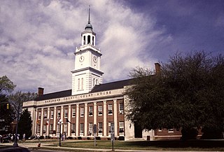
Fairfield County is a county located in the U.S. state of South Carolina. As of the 2020 census, its population was 20,948. Its county seat is Winnsboro.

<span class="mw-page-title-main">Chadbourn, North Carolina</span> Town in North Carolina, United States of America

Chadbourn is a town in Columbus County, North Carolina, United States. The population was 1,856 at the 2010 census.

<span class="mw-page-title-main">Jefferson, South Carolina</span> Town in South Carolina, United States

Jefferson is a town in western Chesterfield County, South Carolina, United States at the junction of SC routes 265 and 151. Jefferson is located in the Piedmont region of South Carolina just in the edge meeting the Sandhills region. Jefferson is located 16 miles northwest of McBee, 8 miles south of Pageland, 50 miles southeast of Charlotte, North Carolina, and 70 miles north-northeast of the state capitol Columbia. As of the 2010 census, the city population was 753.

<span class="mw-page-title-main">Manning, South Carolina</span> City in South Carolina, United States

Manning is a city in and the county seat of Clarendon County, South Carolina, United States. The population was 3,245 as of the 2010 census, with an estimated population in 2018 of 3,941. It was named after former South Carolina governor John Laurence Manning.

<span class="mw-page-title-main">Turbeville, South Carolina</span> Town in South Carolina, United States

Turbeville is a town in Clarendon County, South Carolina, United States. The population was 766 at the 2010 census, up from 602 in 2000.

<span class="mw-page-title-main">Lamar, South Carolina</span> Town in South Carolina, United States

Lamar is a town in Darlington County, South Carolina, United States. The population was 989 at the 2010 census. It is part of the Florence, SC Metropolitan Statistical Area.

<span class="mw-page-title-main">Winnsboro, South Carolina</span> Town in South Carolina, United States

Winnsboro is a town in Fairfield County, South Carolina, United States. The population was 3,550 at the 2010 census. The population was 3,215 at the 2020 census, a population decrease of approximately 9.5% for the same 10 year period. It is the county seat of Fairfield County. Winnsboro is part of the Columbia, South Carolina metropolitan Area as well as a suburb of Columbia.

<span class="mw-page-title-main">Mullins, South Carolina</span> City in South Carolina, United States

Mullins is a city in Marion County, South Carolina, United States. As of the 2010 census, the city population was 4,663.

<span class="mw-page-title-main">Woodruff, South Carolina</span> City in South Carolina, United States

Woodruff is a city in Spartanburg County, South Carolina, United States, located in upstate South Carolina. The population was 4,333 at the 2020 census.

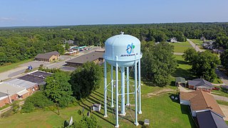
Dalzell is a census-designated place (CDP) in Sumter County, South Carolina, United States. The population was 3,175 at the 2020 census. It is included in the Sumter, South Carolina Metropolitan Statistical Area.

<span class="mw-page-title-main">Mayesville, South Carolina</span> Town in South Carolina, United States

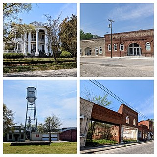
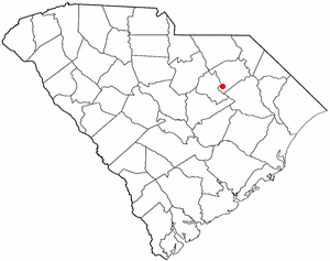
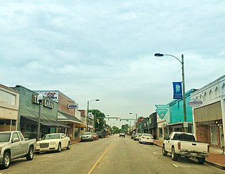
Mayesville is a town in Sumter County, South Carolina, United States. The population was 731 at the 2010 census, this was a decline from 1,001 in 2000. It is included in the Sumter, South Carolina Metropolitan Statistical Area.

<span class="mw-page-title-main">Sumter, South Carolina</span> City in Sumter County, South Carolina, United States

Sumter is a city in and the county seat of Sumter County, South Carolina, United States. The city makes up the Sumter, SC Metropolitan Statistical Area. Sumter County, along with Clarendon and Lee counties, form the core of Sumter–Lee–Clarendon tri-county area of South Carolina that includes three counties straddling the border of the Sandhills, Pee Dee, and Lowcountry regions. The population was 43,463 at the 2020 census, making it the 9th-most populous city in the state.

References

  1. "ArcGIS REST Services Directory". United States Census Bureau. Retrieved October 15, 2022.
  2. 1 2 "Census Population API". United States Census Bureau. Retrieved October 15, 2022.
  3. 1 2 "U.S. Census website". United States Census Bureau . Retrieved January 31, 2008.
  4. "US Board on Geographic Names". United States Geological Survey. October 25, 2007. Retrieved January 31, 2008.
  5. 1 2 "Greeleyville, South Carolina". www.sciway.net. Retrieved December 31, 2022.
  6. Jonté, Bobby. "35 years of Flag Day". Manning Live. Retrieved December 31, 2022.
  7. "More S.C. Festivals". The State (Columbia, South Carolina). October 19, 1997. Retrieved December 31, 2022.
  8. Bierer, Bert W. (1972). South Carolina Indian Lore. Columbia, S.C.: The State Printing Company. pp. 8–9, 13–14.
  9. Paredes, J. Anthony (1992). Indians of the Southeastern United States in the Late 20th Century. Tuscaloosa, AL.: The University of Alabama Press. pp. 75–77.
  10. Hicks, Theresa M. (1998). South Carolina Indians, Indian Traders, and Other Ethnic Connections (1st ed.). Spartanburg, SC: The Reprint Company. p. 263.
  11. Goins, William Moreau (2008). SC Native Pathways: A Visitor's & Resource Guide to American Indian Heritage & Historic Sites in South Carolina. Columbia, S.C.: Phoenix Publishers. p. 40.
  12. Goulding, Shelbie. "Greeleyville Band of Black River Indians regroups with plans to place grave markers in Sumter". The Sumter Item. Retrieved December 31, 2022.
  13. 1 2 3 4 5 Snowden, Yates (1920). History of South Carolina Vol. V. New York: Lewis Publishing Company. p. 100. Retrieved December 31, 2022.
  14. 1 2 3 4 Way, Sammy (January 6, 2013). "Carswell reports on Greeleyville in 1904". The Sumter Item. Newspapers.com. Retrieved December 31, 2022.
  15. 1 2 3 4 Parker, Jim (September 19, 1984). "Residents of Greeleyville like secluded, spruced-up, crime free community". The Gaffney Ledger. Newspapers.com. Retrieved December 31, 2022.
  16. 1 2 3 4 5 Snowden, Yates (1920). History of South Carolina Vol. V. New York: Lewis Publishing Company. pp. 58–59. Retrieved December 31, 2022.
  17. Brown, Linda W. "Empty grocery, Greeleyville, S.C. – Building a better South". www.bettersouth.org. Retrieved December 31, 2022.
  18. Brown, Linda. W. "Main Street, Greeleyville, S.C. – Building a better South". www.bettersouth.org. Retrieved December 31, 2022.
  19. 1 2 3 Caines, Richard. "Jonte - Sabb Farmer's Market and Pavilion celebrates with ribbon cutting". The Post and Courier. Retrieved December 31, 2022.
  20. 1 2 3 "Leonard Jonte Obituary". postandcourier.com. Retrieved December 31, 2022.
  21. "Varner House". SC Picture Project. March 5, 2015. Retrieved December 31, 2022.
  22. Ku Klux Klan : A History of Racism and Violence. Montgomery, AL: Diane Pub Company. 1997. p. 42. ISBN   9780788170317.
  23. Broder, John M. (June 13, 1996). "Clinton Vows to End Burnings of Black Churches". The Los Angeles Times. Newspapers.com. Retrieved December 31, 2022.
  24. Graham, David A. (July 1, 2015). "The Burning and Re-Burning of a Black South Carolina Church". The Atlantic. Retrieved December 31, 2022.
  25. 1 2 3 "National Register Information System". National Register of Historic Places . National Park Service. July 9, 2010.
  26. "Census of Population and Housing". Census.gov. Retrieved June 4, 2015.