Big Springs is an unincorporated community in Calhoun County, West Virginia, United States. It lies along West Virginia Route 16 to the north of the town of Grantsville, the county seat of Calhoun County. Its elevation is 771 feet. It has a post office with the ZIP code 26137.
Elton is an unincorporated community in Summers County, West Virginia, United States. It lies to the northeast of the city of Hinton, the county seat of Summers County. Its elevation is 1,749 feet. Elton had a post office, with the ZIP code of 25965, until it closed on July 11, 2009.
Forest Hill is an unincorporated community in Summers County, West Virginia, United States. It lies along West Virginia Route 12 to the southeast of the city of Hinton, the county seat of Summers County. Its elevation is 1,926 feet. It has a post office with the ZIP code 24935.
Nimitz is an unincorporated community in Summers County, West Virginia, United States. It lies along West Virginia Route 3 to the west of the city of Hinton, the county seat of Summers County. Its elevation is 2,523 feet. It has a post office with the ZIP code 25978.
Pipestem is an unincorporated community in Summers County, West Virginia, United States. It lies along West Virginia Route 20 to the south-southwest of the city of Hinton, the county seat of Summers County. Its elevation is 2,382 feet. It has a post office with the ZIP code 25979. It has a population of 764 people.

Talcott is an unincorporated community in Summers County, West Virginia, United States.

Sandstone is an unincorporated community in Summers County, West Virginia, United States. It lies along West Virginia Route 20 and the New River to the north of the city of Hinton, the county seat of Summers County. Its elevation is 1,352 feet. It has a post office, with the ZIP code of 25985.
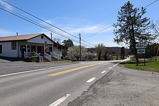
Smoot is an unincorporated community in western Greenbrier County, West Virginia, United States. It lies south of the interchange of Interstate 64 and U.S. Route 60, northwest of the city of Lewisburg, the county seat of Greenbrier County. Its elevation is 2,480 feet (756 m). It has a post office with the ZIP code 24977.
Center Point is an unincorporated community in northeastern Doddridge County, West Virginia, United States. It lies along Route 23 northeast of the town of West Union, the county seat of Doddridge County. Its elevation is 791 feet (241 m).
Midkiff is an unincorporated community in western Lincoln County, West Virginia, United States. It lies along West Virginia Route 10 southwest of the town of Hamlin, the county seat of Lincoln County. Its elevation is 597 feet (182 m). It has a post office with the ZIP code 25540.
Ranger is an unincorporated community in western Lincoln County, West Virginia, United States. It lies along West Virginia Route 10 southwest of the town of Hamlin, the county seat of Lincoln County. Its elevation is 614 feet (187 m). It has a post office with the ZIP code 25557. Ranger is served by the Guyan River VFD.
Pentress is a census-designated place (CDP) in northern Monongalia County, West Virginia, United States. It lies along West Virginia Route 7 northwest of the city of Morgantown, the county seat of Monongalia County. Its elevation is 951 feet (290 m). "Pentress" is not the only name the community has had; at various times in its history, it has been known as Minors Mills, New Brownsville, Pentrees, Pentress Junction, Statler Town, Statlers Town, Statlersville, and Stradlerstown. The present name of Pentress was selected by an early settler who reportedly wanted a Welsh name. It has a post office with the ZIP Code of 26544. As of the 2010 census, its population was 175.
Berea is an unincorporated community in southeastern Ritchie County, West Virginia, United States. It lies along West Virginia Route 74 southeast of the town of Harrisville, the county seat of Ritchie County. Its elevation is 751 feet (229 m). Although it is unincorporated nor has a post office, the ZIP code is 26327. Postal customers are serviced by the Harrisville and Auburn post offices.
Lefor is an unincorporated community in southern Stark County, North Dakota, United States. It lies southeast of the city of Dickinson, the county seat of Stark County. Its elevation is 2,592 feet (790 m). Lefor's post office closed November 2, 2002, but the town still has its own ZIP code of 58641.
Hanna is an unincorporated community in western Duchesne County, Utah, United States, on the Uintah and Ouray Indian Reservation.
Galloway is a census-designated place (CDP) and coal town in northwestern Barbour County, West Virginia, United States. It lies along West Virginia Route 76 northwest of the city of Philippi, the county seat of Barbour County. Its elevation is 1,073 feet (327 m). It has a post office with the ZIP code 26349. As of the 2010 census, its population is 143.
Brohard is an unincorporated community in Ritchie and Wirt counties in the U.S. state of West Virginia. Its elevation is 965 feet (294 m). Brohard had a post office, which closed on November 2, 2002.
Munday is an unincorporated community in eastern Wirt County, West Virginia, United States. It lies along local roads southeast of the town of Elizabeth, the county seat of Wirt County. Its elevation is 717 feet (217 m). Munday had a post office, which closed on October 26, 2002.
Creston is an unincorporated community in southeastern Wirt County, West Virginia, United States. It lies at the confluence of the Little Kanawha River and the West Fork Little Kanawha River on West Virginia Route 5, southeast of the town of Elizabeth, the county seat of Wirt County. Its elevation is 653 feet (199 m). Creston had a post office, which closed on June 25, 2011. The community was named for a drainage divide near the town site.
Blair is an unincorporated community in Fairfield County, South Carolina, United States. The community is located near the Broad River at the county's western border, 18 miles (29 km) west of Winnsboro. Blair has a post office with ZIP code 29015.


