
Khabarovsk is the largest city and the administrative centre of Khabarovsk Krai, Russia, located 30 kilometers (19 mi) from the China–Russia border, at the confluence of the Amur and Ussuri Rivers, about 800 kilometers (500 mi) north of Vladivostok. As of the 2021 Russian census, it had a population of 617,441. The city was the administrative center of the Far Eastern Federal District of Russia from 2002 until December 2018, when the status was given to Vladivostok. It is the largest city in the Russian Far East, having overtaken Vladivostok in 2015. It was known as Khabarovka until 1893. As is typical of the interior of the Russian Far East, Khabarovsk has an extreme climate with strong seasonal swings resulting in strong, cold winters and relatively hot and humid summers.

Khabarovsk Krai is a federal subject of Russia. It is located in the Russian Far East and is administratively part of the Far Eastern Federal District. The administrative centre of the krai is the city of Khabarovsk, which is home to roughly half of the krai's population and the largest city in the Russian Far East. Khabarovsk Krai is the fourth-largest federal subject by area, and had a population of 1,343,869 as of 2010.

Amur Oblast is a federal subject of Russia, located on the banks of the Amur and Zeya rivers in the Russian Far East. Amur Oblast borders Heilongjiang province of the People's Republic of China (PRC) to the south.

The Russian Far East is a region in Northeast Asia. It is the easternmost part of Russia and the Asian continent; and is administered as a part of the Far Eastern Federal District, which is located between Lake Baikal in eastern Siberia and the Pacific Ocean. The area's largest city is Khabarovsk, followed by Vladivostok. The region shares land borders with the countries of Mongolia, China, and North Korea to its south, as well as maritime boundaries with Japan to its southeast, and with the United States along the Bering Strait to its northeast.

The Far Eastern Republic, sometimes called the Chita Republic, was a nominally independent state that existed from April 1920 to November 1922 in the easternmost part of the Russian Far East. Although nominally independent, it largely came under the control of the Russian Soviet Federative Socialist Republic (RSFSR), which envisaged it as a buffer state between the RSFSR and the territories occupied by Japan during the Russian Civil War of 1917–1922. Its first president was Alexander Krasnoshchyokov.

The national flag of Ukraine consists of equally sized horizontal bands of blue and yellow.
The Far Eastern Federal District is the largest of the eight federal districts of Russia but least populated, with a population of around 8 million according to the 2021 Census. The federal district lies entirely within the easternmost part of Asia and is coextensive with the Russian Far East.
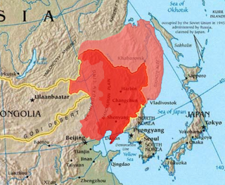
Outer Manchuria, sometimes called Russian Manchuria, refers to a region in Northeast Asia that is now part of the Russian Far East but historically formed part of Manchuria. While Manchuria now more normatively refers to Northeast China, it originally included areas consisting of Priamurye between the left bank of Amur River and the Stanovoy Range to the north, and Primorskaya which covered the area in the right bank of both Ussuri River and the lower Amur River to the Pacific Coast. The region was ruled by a series of Chinese dynasties and the Mongol Empire, but control of the area was ceded to the Russian Empire by the Qing China during the Amur Annexation in the 1858 Treaty of Aigun and 1860 Treaty of Peking, with the terms "Outer Manchuria" and "Russian Manchuria" arising after the Russian annexation. The same general area became known as Green Ukraine after a large number of settlers from Ukraine came to the region.

Primorskaya Oblast was an administrative division of the Russian Empire and the early Russian SFSR, created on October 31, 1856 by the Governing Senate. The name of the region literally means "Maritime" or "Coastal." The region was established upon a Russian conquest of Daur people that used to live along Amur River. Before the Russian conquest of Russian Manchuria, the territory belonged to the Chinese region of Manchuria.
Yurii Kosmych Hlushko (Ukrainian: Ю́рій Косьмич Глушко́, known by the pseudonym Mova, was a Ukrainian public and political figure, one of the organizers of Ukrainian national cultural existence in Green Ukraine.
The Provisional Priamurye Government or Provisional Priamur Government existed in the region of Priamurye of the Russian Far East between May 27, 1921 and June 16, 1923. It was the last Russian State enclave during the Russian Civil War.
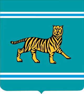
The coat of arms of the Jewish Autonomous Oblast is the official coat of arms of the Jewish Autonomous Oblast in Russia. The coat of arms consists of an Amur tiger standing on four legs with the tail and the head turned upwards, of which the latter is facing the observer. This specific position and occurrence of the Amur tiger in the coat of arms symbolizes the history and development of the Oblast. The coat is a heraldic French shield and the background represents the color of the geographical characteristics of the Russian Far East; which includes taigas, hills, and meadows.
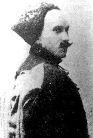
Borys Rostislavovich Khreschatytsky was a general of the Russian Empire. He commanded the Ukrainian troops in the Far East (1918–1924).

Between 1858 and 1860, the Russian Empire annexed territories adjoining the Amur River belonging to the Chinese Qing dynasty through the imposition of unequal treaties. The 1858 Treaty of Aigun, signed by the general Nikolay Muravyov representing the Russian Empire and the official Yishan representing Qing China, ceded Priamurye—a territory stretching from the Amur River north to the Stanovoy Mountains, but the Qing government initially refused to recognize the treaty's validity. Two years later, the Second Opium War concluded with the Convention of Peking, which affirmed the previous treaty as well as an additional cession including the entire Pacific coast to the Korean border, as well as the island of Sakhalin to Russia. These two territories roughly correspond to modern-day Amur Oblast and Primorsky Krai, respectively. Collectively, they are often referred to as Outer Manchuria, part of the greater region of Manchuria.
Grey Ukraine is an unofficial name for a region in Southern Siberia and Northern Kazakhstan, where mass settlement of Ukrainians took place from the middle of the 18th to the beginning of the 20th century. Around 1917–1920 there was a movement for Ukrainian autonomy in the region.

Yellow Ukraine, also known as Zhovty Klyn, is a historical territory with significant Ukrainian settlement in Volga Region.
Klyn is commonly used to refer to various territories historically inhabited by large numbers of Ukrainian people within the modern day Russia.

The Priamur electoral district was a constituency created for the 1917 Russian Constituent Assembly election. The Priamur electoral district consisted of the Amur Oblast, the Maritime Province and the Sakhalin Oblast. However, local leaders had preferred to have three separate constituencies. The election was held on time in the constituency.

Paul Simon Unterberger was a Russo-German military and state leader, military governor of the Primorskaya Oblast (1888–1897), Nizhny Novgorod Governor (1897–1905), Military ataman of the Ussuri Cossack Host, Amur Governor-General (1905–1910), General Engineer.
The Amur Oblast with the center in Blagoveshchensk was formed on December 20, 1858 by the Personal Decree No. 33862. By this Decree, on the proposal of the Governor–General of Eastern Siberia and the Siberian Committee, the Amur Region was made up of lands "located on the left bank of the Amur River, starting from the junction of the Shilka and Argun Rivers or from the borders of the Trans–Baikal and Yakutsk Oblasts, along the entire course of the Amur, to the mouth of the river Ussuri and to the new border of the Primorsky Oblast".


