
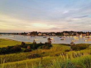
Narragansett is a town in Washington County, Rhode Island, United States. The population was 14,532 at the 2020 census. However, during the summer months the town's population more than doubles to near 34,000. The town of Narragansett occupies a narrow strip of land running along the eastern bank of the Pettaquamscutt River to the shore of Narragansett Bay. It was separated from South Kingstown in 1888 and incorporated as a town in 1901.
Watch Hill is an affluent coastal neighborhood and census-designated place in the town of Westerly, Rhode Island. The population was 154 at the 2010 census. It sits at the most-southwestern point in all of Rhode Island. It came to prominence in the late 19th and early 20th century as an exclusive summer resort, with wealthy families building sprawling Victorian-style "cottages" along the peninsula. Watch Hill is characterized by The New York Times as a community "with a strong sense of privacy and of discreetly used wealth," in contrast with "the overpowering castles of the very rich" in nearby Newport.

Saunderstown is a small village and historic district in the towns of Narragansett and North Kingstown in Washington County, Rhode Island, United States. Saunderstown has its own post office with the ZIP Code of 02874, which also includes a small part of South Kingstown. Its population is 6,245.

Goat Island is a small island in Narragansett Bay and is part of the city of Newport, Rhode Island, U.S. The island is connected to the Easton's Point neighborhood via a causeway bridge. It is home to the Newport Harbor Light (1842), residences, a restaurant, event space, and hotel. It was also home to several military forts and to the U.S. Naval Torpedo Station, and was the site of the attacks on HMS St John and HMS Liberty.

Castle Hill Lighthouse is located on Narragansett Bay in Newport, Rhode Island at the end of the historic Ocean Drive. It is an active navigation aid for vessels entering the East Passage, between Conanicut Island and Aquidneck Island. The lighthouse has become a symbol of Newport, and a frequent site for wedding photos, proposals, and tourist photos. Although the property is owned by the nearby Castle Hill Inn, the lighthouse is owned by the United States Coast Guard.
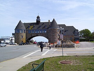
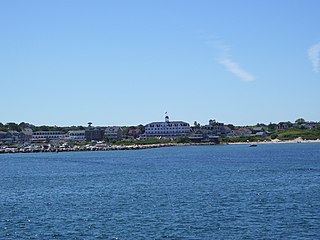
The Towers is a historic structure located at 35 Ocean Road in Narragansett, Rhode Island, USA. It is the only remnant of the Narragansett Pier Casino built in the 1880s. On November 25, 1969, it was added to the National Register of Historic Places.

The South Street Station is an historic electrical power generation station at 360 Eddy Street in Providence, Rhode Island. The structure has since been redeveloped and is now used as an administrative office and academic facility by a number of local universities.

The Central Street Historic District of Narragansett, Rhode Island is a historic district on both sides of Central Street from Fifth Avenue to Boon Street in Narragansett. It encompasses a collection of well-preserved summer houses built for the most part between 1880 and the 1920s, as well as the traditional civic core of the town. The area is characterized by smaller wood-frame homes, generally either 1-1/2 or 2+1⁄2 stories in height, set on small lots. It includes three church buildings, all of which were built between 1870 and 1900, and the former Fifth Avenue School, which now serves as Narragansett's town hall.

The Crowfield Historic District is a small residential historic district in North Kingstown, Rhode Island. It encompasses a cluster of four early 20th-century summer houses, all connected via family or friendship connections to the writer Owen Wister. The occupy a large parcel of land sloping down to the shore of Narragansett Bay on the east side of Boston Neck Road, a short way north of the Jamestown Verrazzano Bridge. The area was named "Crowfield" by Elizabeth Middleton Cope, who built a Shingle-style mansion in 1906. Owen Wister, her uncle, built his house, Champ de Corbeau, in 1909-10 to a design by Grant Lafarge. The Jamieson House was also built in 1906, and was designed by the same architect, James P. Jamieson. The fourth house, Orchard House, was built in 1924. All are Shingle style houses. The compound is unusual for North Kingstown, where most summer estates were isolated individual properties.

Earlscourt Historic District is a residential historic district in Narragansett, Rhode Island, United States. It is centered on a stretch of Earles Court, between Gibson Avenue and Noble Street, and includes a few properties on the adjacent Gibson Avenue and Woodward and Westminster Streets. It includes nine residential properties developed in the 1880s and 1890s, during the height of Narragansett Pier's popularity as a summer resort community. All are in the then-popular Shingle Style, and most were designed by well-known architects. The Sherry Cottages, a series of four buildings on Gibson Avenue, were all designed by McKim, Mead & White, who also designed The Towers. The other development is that on Earles Court, designed by D. J. Jardine and Constable Brothers for Edward Earle, a New York lawyer. The central focus of this development is a stone water tower which bisects the roadway.
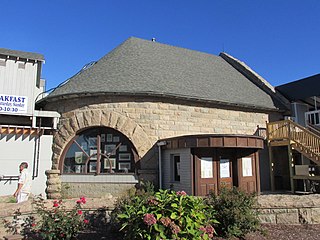
The Coast Guard House is an historic lifesaving station at 40 Ocean Road in Narragansett, Rhode Island.
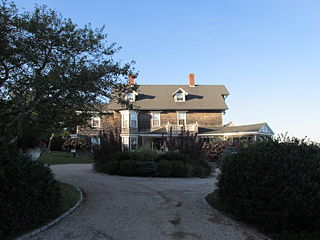
The Ocean Road Historic District is a residential historic district, encompassing an area of fashionable summer houses built in the late 19th and early 20th centuries in Narragansett, Rhode Island. The area is located south of The Towers, the center of the Narragansett Pier area, extending along Ocean Road roughly from Hazard Street to Wildfield Farm Road. Many of the 45 houses in the district were built between about 1880 and 1900, with a few built earlier and later. The Shingle style is prominent in the architectural styles found, including among houses designed by architects, including McKim, Mead & White and William Gibbons Preston. The most unusual property is called Hazard's Castle, a rambling stone structure built beginning in the 1840s by Joseph Peace Hazard, who was a major landowner in the area prior to its development in the 1880s.
The Old Harbor Historic District is an historic district in the resort community of New Shoreham on Block Island off the southern coast of Rhode Island. Bounded by the Atlantic Ocean and Main Street, it includes Spring, High, and Water streets as well. There are 42 buildings listed in the district, which was listed on the National Register of Historic Places in 1974.

The Towers Historic District is a historic district in Narragansett, Rhode Island, encompassing a city block bounded by the Atlantic Ocean, Exchange Place, Mathewson and Taylor Streets. It is centered on The Towers, the surviving remnant of the Narragansett Casino, built 1883-86 to a design by McKim, Mead & White. This area was always near the center of resort-oriented development in Narragansett from the mid-19th century on, including four summer cottages on Taylor and Mathewson Streets built in the 1860s and 1870s. Most of the casino was destroyed by fire in 1900, leaving its stone towers, and the nearby Coast Guard station, also designed by McKim, Mead & White. The oldest building in the district is an 1822 2+1⁄2-story house at 18 Mathewson Street.

The Benjamin Aborn Jackson House is an historic house at 115 Nayatt Road in Barrington, Rhode Island. The 2+1⁄2-story brick house was designed by Norman Isham and completed in 1913 for Benjamin Aborn Jackson, a Rhode Island banking and railroad executive. The house is a rare survivor of the development of Nayatt Point as a resort area. The L-shaped building is set well back from Nayatt Road, and is not far from the Nayatt Point Light.

Rosedale Apartments are a historic apartment house at 1180 Narragansett Boulevard in Cranston, Rhode Island. This U-shaped apartment block stands overlooking Narragansett Bay, with three stories facing the street and four toward the bay. The Art Moderne structure was designed by Herbert R. Hunt and built in 1939–40. It is a rare statewide example of a large-scale building in this style, and was one of only a few built in Cranston before the Second World War.

William Gibbons Preston was an American architect who practiced during the last third of the nineteenth century and in the first decade of the twentieth. Educated at Harvard University and the École des Beaux-Arts in Paris., he was active in Boston, New York, Rhode Island, Ohio, New Brunswick and Savannah, Georgia, where he was brought by George Johnson Baldwin to design the Chatham County courthouse. Preston stayed in Savannah for several years during which time designed the original Desoto Hotel, the Savannah Volunteer Guards Armory and 20 other distinguished public buildings and private homes. He began his professional career working for his father, the builder and architect Jonathan Preston (1801–1888), upon his return to the United States from the École in 1861, and was the sole practitioner in the office from the time his father retired c. 1875 until he took John Kahlmeyer as a partner in about 1885.

Willard Kent (1851–1924) was an architect and engineer of Woonsocket, Rhode Island.
The Anthony–Kinney Farm is a historic farm and resort complex at 505 Point Judith Road in Narragansett, Rhode Island. The property, now a town-owned recreation area known as Sunset Farm, saw agricultural use for over 300 years, and was converted into a private resort around the turn of the 20th century. The Point Judith area was among the first in Rhode Island to be purchased from the local Narragansett people, in 1657. The farm was acquired by James E. Anthony in 1850, who sold it to Francis Kinney in 1897. Kinney maintained much of the land in agricultural use, but built an extravagant resort complex, including a distinctive East Indian bungalow as a clubhouse, and built a private nine-hole golf course. Kinney died in 1908, and the property was owned by the Chase family until 1991, when most of it was purchased by the town. It is managed by the town as an active farm, and the restored clubhouse is available for rent as function space.

The Edgewood Historic District–Anstis Greene Estate Plat is a residential historic district in the Edgewood neighborhood of eastern Cranston, Rhode Island. The 34-acre (14 ha) area is bounded on the west by Broad Street, the east by Narragansett Bay, the south by Rosewood Avenue, and on the north by Marion Avenue, where it abuts the Edgewood Historic District-Shaw Plat. The area, originally part of a much larger property belonging to Zachariah Rhodes in the 17th century, was platted for residential development in the decades following the arrival of the streetcar on Broad Street, providing commuter service to Providence. The land was willed by Anstis Rhodes Greene to a group of heirs, who progressively developed their individual portions. The only significant surviving elements that predate this development are two small family cemeteries.


