Guest River

Last updated

Coordinates: 36°52′34″N82°30′1″W / 36.87611°N 82.50028°W / 36.87611; -82.50028

Geographic coordinate system Coordinate system

A geographic coordinate system is a coordinate system that enables every location on Earth to be specified by a set of numbers, letters or symbols. The coordinates are often chosen such that one of the numbers represents a vertical position and two or three of the numbers represent a horizontal position; alternatively, a geographic position may be expressed in a combined three-dimensional Cartesian vector. A common choice of coordinates is latitude, longitude and elevation. To specify a location on a plane requires a map projection.

Contents

The Guest River Guest River.jpg
The Guest River

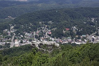
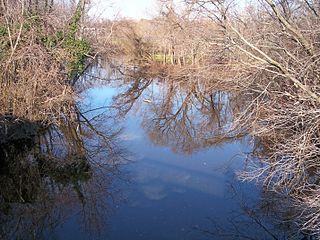
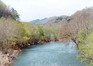
The Guest River is a short tributary of the Clinch River in southwestern Virginia in the United States. It is part of the watershed of the Mississippi River by way of the Clinch, Tennessee and Ohio Rivers. According to the Geographic Names Information System, the river has also been known historically as the Guests River. [1]

Tributary stream or river that flows into a main stem river or lake

A tributary or affluent is a stream or river that flows into a larger stream or main stem river or a lake. A tributary does not flow directly into a sea or ocean. Tributaries and the main stem river drain the surrounding drainage basin of its surface water and groundwater, leading the water out into an ocean.

Clinch River river in the United States of America

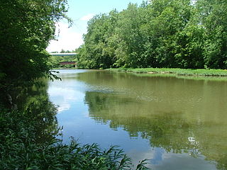
The Clinch River rises near Tazewell, Virginia, and flows southwest for more than 300 miles (480 km) through the Great Appalachian Valley, gathering various tributaries, including the Powell River, before joining the Tennessee River in Kingston, Tennessee.

Southwest Virginia

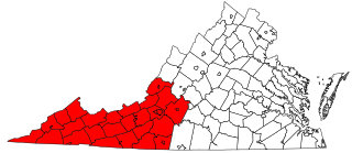
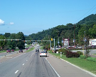
Southwest Virginia, often abbreviated as SWVA, is a mountainous region of Virginia in the westernmost part of the commonwealth. Located within the broader region of western Virginia, Southwest Virginia has been defined alternatively as all Virginia counties on the Appalachian Plateau, all Virginia counties west of the Eastern Continental Divide, or at its greatest expanse, as far east as Blacksburg and Roanoke. Another geographic categorization of the region places it as those counties within the Tennessee River watershed. Regardless of how borders are drawn, Southwest Virginia differs from the rest of the commonwealth in that its culture is more closely associated with Appalachia than the other regions of Virginia. Historically, the region has been and remains rural, but in the 20th century, coal mining became an important part of its economy. With the decline in the number of coal jobs and the decline of tobacco as a cash crop, Southwest Virginia is increasingly turning to tourism as a source of economic development. Collectively, Southwest Virginia's craft, music, agritourism and outdoor recreation are referred to as the region's "creative economy."

Course

The Guest River flows for nearly its entire length in Wise County. It rises in the north-central part of the county and flows initially south-southeastwardly to the city of Norton; then eastwardly to the town of Coeburn; then southeastwardly for the remainder of its course. It flows into the Clinch on the common boundary of Wise and Scott Counties. Portions of the river flow through the Jefferson National Forest. [2] The Guest River's lower course below Coeburn is paralleled by the Guest River Gorge Trail, formerly the Interstate Railroad. [3] The section of river which runs along the Guest River Trail contains multiple class 4 and 5 rapids.[ citation needed ]

Wise County, Virginia County in the United States

Wise County is a county located in the U.S. state of Virginia. As of the 2010 census, the population was 41,452. Its county seat is Wise. The county was formed in 1856 from Lee, Scott, and Russell Counties and named for Henry A. Wise, who was the Governor of Virginia at the time.

Norton, Virginia Independent city in Virginia, United States

Norton is an independent city in the Commonwealth of Virginia. As of the 2010 census, the population was 3,958, making it the least populous city in Virginia, along with the westernmost. The Bureau of Economic Analysis combines the city of Norton with surrounding Wise County for statistical purposes.

Coeburn, Virginia Town in Virginia, United States

Coeburn is a town in Wise County, Virginia, along the Guest River. The population was 2139 at the 2010 census with many small peaceful wooded communities in the outskirts. Camping is available nearby at Bark Camp Lake in the Jefferson National Forest with other activities including boating and fishing. The Guest River Gorge Trail, built along the Guest River on what was formerly the Interstate Railroad, is also located in the Jefferson National Forest and is a popular place to walk or ride a bicycle. Recently Coeburn joined with neighboring town Saint Paul on the Mountain View Trail System for ATVs

See also

Related Research Articles

St. Jones River river in Delaware, United States of America

The St. Jones River is a river flowing to Delaware Bay in central Delaware in the United States. It is 12.8 miles (20.6 km) long and drains an area of 36 square miles (93 km2) on the Atlantic Coastal Plain. The river is believed to have been named either for Robert Jones, an early European property owner in the region, or for "St. Jone", the Welsh spelling of St. John.

Kokosing River river in the United States of America

The Kokosing River (ko-KO-sing) is a tributary of the Walhonding River, 57.2 miles (92.1 km) long, in east-central Ohio in the United States. Via the Walhonding, Muskingum and Ohio Rivers, it is part of the watershed of the Mississippi River, draining an area of 482 square miles (1248 km²). Etymologically, "Kokosing" translates roughly to "River of Little Owls." The Kokosing River rises in Morrow County, northeast of Mount Gilead, and initially flows southwardly. It turns eastwardly near Chesterville and flows through Knox and Coshocton Counties, passing the communities of Mount Vernon, Howard and Gambier. In western Coshocton County the Kokosing joins the Mohican River to form the Walhonding River, about 2 miles (3 km) northwest of Nellie.

Pamunkey River river in the United States of America

The Pamunkey River is a tributary of the York River, about 93 miles (150 km) long, in eastern Virginia in the United States. Via the York River it is part of the watershed of Chesapeake Bay.

North Anna River river in the United States of America

The North Anna River is a principal tributary of the Pamunkey River, about 62 miles (100 km) long, in central Virginia in the United States. Via the Pamunkey and York rivers, it is part of the watershed of Chesapeake Bay. The river was the site of the Battle of North Anna during the American Civil War.

The South Anna River is a principal tributary of the Pamunkey River, about 102 miles (164 km) long, in central Virginia in the United States. Via the Pamunkey and York rivers, it is part of the watershed of Chesapeake Bay.

The Hardware River is a 23.3-mile-long (37.5 km) tributary of the James River in central Virginia in the United States. It is part of the watershed of Chesapeake Bay.

The Willis River is a 61.8-mile-long (99.5 km) tributary of the James River in central Virginia in the United States. Via the James River, it is part of the watershed of Chesapeake Bay.

The Rockfish River is a 28.7-mile-long (46.2 km) tributary of the James River in central Virginia in the United States. Via the James River, it is part of the watershed of the Chesapeake Bay.

Baraboo River river in the United States of America

The Baraboo River is a tributary of the Wisconsin River, about 70 mi (115 km) long, in south-central Wisconsin in the United States. Via the Wisconsin River, it is part of the watershed of the Mississippi River.

Licking River (Ohio) tributary of the Muskingum River in central Ohio in the United States

The Licking River is a tributary of the Muskingum River, about 40 mi (65 km) long, in central Ohio in the United States. Via the Muskingum and Ohio Rivers, it is part of the watershed of the Mississippi River.

The First Broad River is a tributary of the Broad River, about 60 mi (95 km) long in western North Carolina in the United States. Via the Broad and Congaree Rivers, it is part of the watershed of the Santee River, which flows to the Atlantic Ocean.

Paint Creek (Scioto River tributary) river in the United States of America

Paint Creek is a tributary of the Scioto River, 94.7 mi (152.5 km) long, in south-central Ohio in the United States. Via the Scioto and Ohio Rivers, it is part of the watershed of the Mississippi River. It drains an area of 1,143 mi² (2960 km²).

The Mitchell River is a tributary of the Yadkin River in northwestern North Carolina in the United States. Via the Yadkin it is part of the watershed of the Pee Dee River, which flows to the Atlantic Ocean. According to the Geographic Names Information System, it has also been known historically as "Mitchells River," "Mitchels River," and "Mountain Creek."

The Roaring River is a tributary of the Yadkin River in northwestern North Carolina in the United States. Via the Yadkin it is part of the watershed of the Pee Dee River, which flows to the Atlantic Ocean. According to the Geographic Names Information System, it has also been known historically as "Roaring Creek." The river's name comes from its headwaters in the Blue Ridge Mountains, where it flows through a series of small waterfalls.

The Reddies River is a tributary of the Yadkin River in northwestern North Carolina in the United States. Via the Yadkin it is part of the watershed of the Pee Dee River, which flows to the Atlantic Ocean. According to the Geographic Names Information System, it has also been known historically as "Reddis River."

The Ararat River is a tributary of the Yadkin River in southwestern Virginia and northwestern North Carolina in the United States. Via the Yadkin it is part of the watershed of the Pee Dee River, which flows to the Atlantic Ocean.

Ottauquechee River river in the United States of America

The Ottauquechee River is a 41.4-mile-long (66.6 km) river in eastern Vermont in the United States. It is a tributary of the Connecticut River, which flows to Long Island Sound.

Leading Creek (Ohio)

Leading Creek is a tributary of the Ohio River, 29.5 miles (47.5 km) long, in southeastern Ohio in the United States. Via the Ohio River, it is part of the watershed of the Mississippi River, draining an area of 150 square miles (390 km2) on the unglaciated portion of the Allegheny Plateau. The creek's headwaters are in southern Athens County and it flows for most of its length in western Meigs County; its tributaries also drain a small area of northeastern Gallia County.

References

  1. U.S. Geological Survey Geographic Names Information System: Guest River
  2. DeLorme (2005). Virginia Atlas & Gazetteer. Yarmouth, Maine: DeLorme. ISBN   0-89933-326-5.
  3. Guest River Gorge Trail website