
The Gulf Trough, also known as the Suwanee Straits, [1] is an ancient geologic feature of Florida present during the Paleogene period. A strong marine current, similar to the Gulf Stream, scoured the trough from southwest to northeast.
The Gulf Trough, also known as the Suwanee Straits, [1] is an ancient geologic feature of Florida present during the Paleogene period. A strong marine current, similar to the Gulf Stream, scoured the trough from southwest to northeast.
During the Paleogene, what would become Florida was the submerged Florida Platform, a feature not unlike the Bahama Banks composed of carbonate sediments containing foraminifera, corals, bryozoa, and mollusks. Due to the current running through the Gulf Trough, materials needed for sedimentation were instead carried away toward the northeast.
During the Eocene through Oligocene, a period of roughly 32.8 million years, material born of erosion began building up more rapidly in the Gulf Trough, due to the uplifting of the Appalachian Mountains to the north, which provided the primary source of siliciclastic material transported south via streams. By the Early Miocene, considered the start of the Neogene, the trough was filled, and materials continued to move southward covering and replacing the carbonate-depositing marine environment with sands, silts, and clays; these sediments created the peninsula on which terrestrial flora and fauna could become established. [2]

Limestone is a type of carbonate sedimentary rock which is the main source of the material lime. It is composed mostly of the minerals calcite and aragonite, which are different crystal forms of CaCO3. Limestone forms when these minerals precipitate out of water containing dissolved calcium. This can take place through both biological and nonbiological processes, though biological processes, such as the accumulation of corals and shells in the sea, have likely been more important for the last 540 million years. Limestone often contains fossils which provide scientists with information on ancient environments and on the evolution of life.

The Neogene is a geologic period and system that spans 20.45 million years from the end of the Paleogene Period 23.03 million years ago (Mya) to the beginning of the present Quaternary Period 2.58 million years ago. The Neogene is sub-divided into two epochs, the earlier Miocene and the later Pliocene. Some geologists assert that the Neogene cannot be clearly delineated from the modern geological period, the Quaternary. The term "Neogene" was coined in 1853 by the Austrian palaeontologist Moritz Hörnes (1815–1868). The earlier term Tertiary Period was used to define the span of time now covered by Paleogene and Neogene and, despite no longer being recognized as a formal stratigraphic term, "Tertiary" still sometimes remains in informal use.

Coquina is a sedimentary rock that is composed either wholly or almost entirely of the transported, abraded, and mechanically sorted fragments of mollusks, trilobites, brachiopods, or other invertebrates. The term coquina comes from the Spanish word for "cockle" and "shellfish".
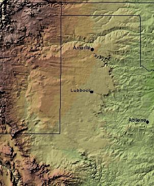
Texas contains a wide variety of geologic settings. The state's stratigraphy has been largely influenced by marine transgressive-regressive cycles during the Phanerozoic, with a lesser but still significant contribution from late Cenozoic tectonic activity, as well as the remnants of a Paleozoic mountain range.

In geology, cross-bedding, also known as cross-stratification, is layering within a stratum and at an angle to the main bedding plane. The sedimentary structures which result are roughly horizontal units composed of inclined layers. The original depositional layering is tilted, such tilting not being the result of post-depositional deformation. Cross-beds or "sets" are the groups of inclined layers, which are known as cross-strata.

In geology, depositional environment or sedimentary environment describes the combination of physical, chemical, and biological processes associated with the deposition of a particular type of sediment and, therefore, the rock types that will be formed after lithification, if the sediment is preserved in the rock record. In most cases, the environments associated with particular rock types or associations of rock types can be matched to existing analogues. However, the further back in geological time sediments were deposited, the more likely that direct modern analogues are not available.

The geology of the Iberian Peninsula consists of the study of the rock formations on the Iberian Peninsula, which includes Spain, Portugal, Andorra, and Gibraltar. The peninsula contains rocks from every geological period from the Ediacaran to the Quaternary, and many types of rock are represented. World-class mineral deposits are also found there.

The Coyote Mountains are a small mountain range in San Diego and Imperial Counties in southern California. The Coyotes form a narrow ESE trending 2 mi (3.2 km) wide range with a length of about 12 mi (19 km). The southeast end turns and forms a 2 mi (3.2 km) north trending "hook". The highest point is Carrizo Mountain on the northeast end with an elevation of 2,408 feet (734 m). Mine Peak at the northwest end of the range has an elevation of 1,850 ft (560 m). Coyote Wash along I-8 along the southeast margin of the range is 100 to 300 feet in elevation. Plaster City lies in the Yuha Desert about 5.5 mi (8.9 km) east of the east end of the range.
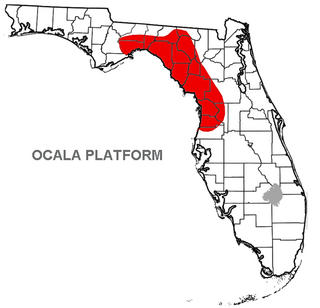
The Ocala Platform or Ocala Uplift is a geologic feature, a structural high, and a northwest-trending uplift paralleling the Peninsular Arch along the west coast of Florida.
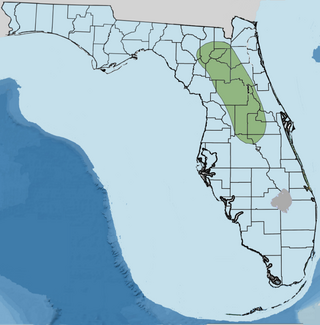
Orange Island is the earliest emergent landmass of Florida dating from the middle Rupelian ~33.9—28.4 Ma. geologic stage of the Early Oligocene epoch and named for Orange County, Florida, United States of America.
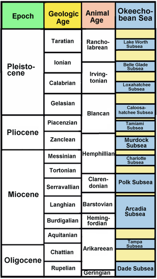
The Okeechobean Sea was a Cenozoic eutropical subsea, which along with the Choctaw Sea, occupied the eastern Gulf of Mexico basin system bounding Florida.
Paleontology in Louisiana refers to paleontological research occurring within or conducted by people from the U.S. state of Louisiana. Outcrops of fossil-bearing sediments and sedimentary rocks within Louisiana are quite rare. In part, this is because Louisiana’s semi-humid climate results in the rapid weathering and erosion of any exposures and the growth of thick vegetation that conceal any fossil-bearing strata. In addition, Holocene alluvial sediments left behind by rivers like the Mississippi, Red, and Ouachita, as well as marsh deposits, cover about 55% of Louisiana and deeply bury local fossiliferous strata.
The Alum Bluff Group is a geologic group in the states of Georgia, Florida, and Alabama. It preserves fossils dating back to the Neogene period.
The geology of Guinea-Bissau is oldest in the east and becomes younger toward the west, with sediments from the past 66 million years nearer the coast. Some rock units in the northeast are as much as 680 million years old and throughout the geologic past Guinea-Bissau was influenced by the Mauritanide Belt orogeny and was submerged or partially submerged as a marine shelf or river delta for most of its existence.
The geology of Malawi formed on extremely ancient crystalline basement rock, which was metamorphosed and intruded by igneous rocks during several orogeny mountain building events in the past one billion years. The rocks of the Karoo Supergroup and newer sedimentary units deposited across much of Malawi in the last 251 million years, in connection with a large rift basin on the supercontinent Gondwana and the more recent rifting that has created the East African Rift, which holds Lake Malawi. The country has extensive mineral reserves, many of them poorly understood or not exploited, including coal, vermiculite, rare earth elements and bauxite.
The geology of Arkansas includes deep 1.4 billion year old igneous crystalline basement rock from the Proterozoic known only from boreholes, overlain by extensive sedimentary rocks and some volcanic rocks. The region was a shallow marine, riverine and coastal environment for much of the early Paleozoic as multi-cellular life became commonplace. At the end of the Paleozoic in the Permian the region experienced coal formation and extensive faulting and uplift related to the Ouachita orogeny mountain building event. Extensive erosion of new highlands created a mixture of continental and marine sediments and much of the state remained flooded even into the last 66 million years of the Cenozoic. In recent Pleistocene and Holocene time, glacial sediments poured into the region from the north, down major rivers, forming dunes and sedimentary ridges. Today, Arkansas has an active oil and gas industry, although hydraulic fracturing related earthquake swarms have limited extraction. Mining industries in the state also produce brines, sand, gravel and other industrial minerals.
The geology of Belgium encompasses rocks, minerals and tectonic events stretching back more than 500 million years. Belgium covers an area of about 30,507 square kilometers and was instrumental in the development of geology. The extensive outcrops in Belgium became the standard reference points in stratigraphy as early as the mid-19th century. Some of them are internationally recognized features related to the Carboniferous and the Devonian periods. These rocks were folded by two mountain building events: the Hercynian orogeny and Caledonian Orogeny. Paleozoic basement rocks cover much of the country and are overlain by Mesozoic and Cenozoic sediments.

The geology of Croatia has some Precambrian rocks mostly covered by younger sedimentary rocks and deformed or superimposed by tectonic activity.
The geology of Denmark includes 12 kilometers of unmetamorphosed sediments lying atop the Precambrian Fennoscandian Shield, the Norwegian-Scottish Caledonides and buried North German-Polish Caledonides. The stable Fennoscandian Shield formed from 1.45 billion years ago to 850 million years ago in the Proterozoic. The Fennoscandian Border Zone is a large fault, bounding the deep basement rock of the Danish Basin—a trough between the Border Zone and the Ringkobing-Fyn High. The Sorgenfrei-Tornquist Zone is a fault-bounded area displaying Cretaceous-Cenozoic inversion.
The geology of Saudi Arabia includes Precambrian igneous and metamorphic basement rocks, exposed across much of the country. Thick sedimentary sequences from the Phanerozoic dominate much of the country's surface and host oil.