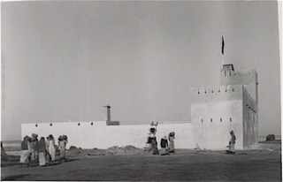
The Hawar Islands are an archipelago of desert islands; all but one are owned by Bahrain, while the southern, small, and uninhabited Jinan Island is administered by Qatar as part of its Al-Shahaniya municipality. The archipelago is situated off the west coast of Qatar in the Gulf of Bahrain of the Persian Gulf.

The Persian Gulf, sometimes called the Arabian Gulf, is a mediterranean sea in West Asia. The body of water is an extension of the Indian Ocean located between Iran and the Arabian Peninsula. It is connected to the Gulf of Oman in the east by the Strait of Hormuz. The Shatt al-Arab river delta forms the northwest shoreline.

The history of Qatar spans from its first duration of human occupation to its formation as a modern state. Human occupation of Qatar dates back to 50,000 years ago, and Stone Age encampments and tools have been unearthed in the Arabian Peninsula. Mesopotamia was the first civilization to have a presence in the area during the Neolithic period, evidenced by the discovery of potsherds originating from the Ubaid period near coastal encampments.

Qatar is a peninsula in the east of Arabia, bordering the Persian Gulf and Saudi Arabia, in a strategic location near major petroleum and natural gas deposits. The State of Qatar occupies 11,571 km2 (4,468 sq mi) on a peninsula that extends approximately to 160 km (99 mi) north into the Persian Gulf from the Arabian Peninsula.

The Arabian Peninsula, or Arabia, is a peninsula in West Asia, situated northeast of Africa on the Arabian Plate. At 3,237,500 km2 (1,250,000 sq mi), the Arabian Peninsula is the largest peninsula in the world.

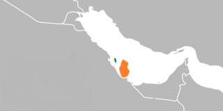
The Kingdom of Bahrain consists of Bahrain Island and 33 of the p37 Bahrain Islands, lying in the Persian Gulf's Gulf of Bahrain off the north shore of West Asia's Arabian Peninsula. Bahrain's capital city is Manama. The islands are about 24 kilometers (15 mi) off the east coast of Saudi Arabia and 28 kilometers (17 mi) from Qatar. The total area of the country is about 694 square kilometers (268 sq mi), about four times the size of the District of Columbia.

Transport in Bahrain encompasses road transportation by car, air transportation and shipping. It has been announced that a monorail network will be constructed.

The Eastern Province, also known as the Eastern Region, is the easternmost of the 13 provinces of Saudi Arabia. It is the largest province by area and the third most populous after the Riyadh Province and the Mecca Province. In 2017, the population was 4,900,325. Of these, 3,140,362 were Saudi citizens and 1,759,963 were foreign nationals The province accounts for 15.05% of the entire population of Saudi Arabia and is named for its geographical location relative to the rest of the kingdom.

Dammam is the fourth-most populous city in Saudi Arabia after Riyadh, Jeddah, and Mecca. It's the capital of the Eastern Province, with a total population of 1,532,300 as of 2022. The judicial and administrative bodies of the province, in addition to the administrative offices of other minor governmental departments functioning within the province, are located in the city. The word itself is generally used to refer to the city, but may also refer to its eponymous governorate.

Khobar is a city and governorate in the Eastern Province of the Kingdom of Saudi Arabia, situated on the coast of the Persian Gulf. With a population of 457,748 as of 2017, Khobar is part of the 'Triplet Cities' area, or Dammam metropolitan area along with Dammam and Dhahran, forming the residential core of the region.

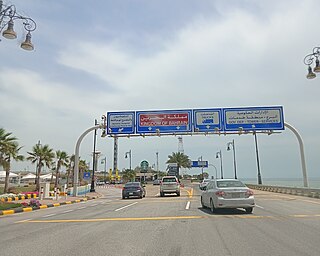
The King Fahd Causeway is a 25 km long series of bridges and causeways connecting Khobar, Saudi Arabia, and Al Jasra, Bahrain.

The Qatar Bahrain Causeway was a planned causeway between the two Arab states of Qatar and Bahrain. It was also expected that a ferry service would be established between the two countries in 2017.
This article deals with territorial disputes between states of in and around the Persian Gulf in Southwestern Asia. These states include Iran, Iraq, Kuwait, Saudi Arabia, Bahrain, Qatar, the United Arab Emirates (UAE), and Oman.
Bahrain Island, also known as al-Awal Island and formerly as Bahrein, is the largest island within the archipelago of Bahrain, and forms the bulk of the country's land mass while hosting the majority of its population.
Umm an Nasan island is the fifth largest island in Bahrain. It is 17.5 km (10.9 mi) west of the capital, Manama, on Bahrain Island.

The Gulf of Salwah is the southern portion of the Gulf of Bahrain. The Gulf of Salwah is a narrow bay separating the peninsula of Qatar from Saudi Arabia. It is bordered to the west by a well-vegetated shoreland containing palm trees and reed beds. To the east are low cliffs and hills, with sand dunes and salt flats at the southern end.
Bilateral relations exist between the State of Qatar and the Kingdom of Bahrain. They first began in 1971.
The wildlife of Bahrain is the flora and fauna of the archipelago of Bahrain. Apart from a strip of the north and west of the main island, where crops such as potatoes are grown with irrigation, the land is arid. With a very hot dry summer, a mild winter, and brackish groundwater, the plants need adaptations in order to survive. Nevertheless, 196 species of higher plant have been recorded here, as well as about seventeen species of terrestrial mammals, many birds and reptiles, and many migratory birds visit the islands in autumn and spring.
King Fahd Passport Island, or simply Passport Island, is an artificial island partitioned between Bahrain and Saudi Arabia in the Gulf of Bahrain. Spread across 2.5 km (1.6 mi), it serves as the sole border crossing between the two countries and is used for connecting Saudi Arabia's Eastern Province to Bahrain's Northern Governorate through the King Fahd Causeway.


