
James Barney Marsh was an American engineer and bridge designer. He patented a new design for arch bridges. Marsh gave Archie Alexander, the first African-American to graduate as an engineer from Iowa State University, his first job. Marsh worked in the bridge building business for over 50 years, and several of his bridges are listed in the National Register of Historic Places.

The County Line Bowstring is a bridge located near unincorporated Hollis, Kansas, United States, that is listed on the National Register of Historic Places. It spans West Creek on the border between Cloud and Republic counties and has a wooden deck with a bowstring pony truss.

The Union Covered Bridge State Historic Site is a Missouri State Historic Site in Monroe County, Missouri. The covered bridge is a Burr-arch truss structure built in 1871 over the Elk Fork of the Salt River. It was almost lost to neglect in the 1960s, but was added to the state park system in 1967, the same year it was damaged by a flood. Repairs were made the next year, using timbers salvaged from another covered bridge that had been destroyed by the same flood. In 1970, it was closed to vehicular traffic and was added to the National Register of Historic Places. Further repairs were made in 1988, and it survived the Great Flood of 1993, only to be damaged by another flood in 2008 and later re-repaired. It is about 120 feet (37 m) or 125 feet (38 m) long, 12 feet (3.7 m) high, and 17.5 feet (5.3 m) wide.

There are eight properties listed on the National Register of Historic Places (NRHP) in Linn County, Kansas. Two of the sites are the location of historic events. The Marais des Cygnes Massacre Site is the location of the Marais des Cygnes massacre, an 1858 event during Bleeding Kansas in which pro-slavery advocates kidnapped 11 anti-slavery settlers, killing five of them. John Brown temporarily used the site as a fort, and the property was listed on the NRHP in 1971. The Battle of Mine Creek Site preserves the location of the Battle of Mine Creek, which was fought in 1864 as part of Price's Raid during the American Civil War. Confederate general Sterling Price's army was retreating after being defeated at the Battle of Westport and was attacked by pursuing Union troops. Price's Confederate lost heavily in men and supplies. The site was added to the NRHP in 1973.

Bridge No. 1860, also known as the Samson Occom Bridge, is a fieldstone arch bridge in Montville, Connecticut, United States. Constructed by the Connecticut State Highway Department in 1936 as a Works Progress Administration project, it is located on Mohegan tribal land in an area that was once a part of Fort Shantok State Park. The bridge carries traffic from Massapeag Side Road over the Shantok Brook, a tributary of the Thames River. Spanning 12 feet (3.7 m) across the brook, the bridge's arch rises about 6 feet (1.8 m) above the water. According to a 2011 Connecticut Department of Transportation report, it carries 1,100 vehicles per day. Samson Occom Bridge was listed on the National Register of Historic Places in 1993.

The Morton County WPA Bridge, near Richfield, Kansas, United States, is a stone multi-arch bridge that was built from 1936 to 1939 by the Works Progress Administration (WPA). It was listed on the National Register of Historic Places in 1986.

The Hodgeman County Courthouse, at 500 Main St. in Jetmore, Kansas, was built in 1929. It was designed and built by Routledge & Hertz of Hutchinson, Kansas in an "eclectic interpretation" of Second Renaissance Revival style. It was listed on the National Register of Historic Places in 2002.

The Landers Creek Bridge, also known as the Goodrich Bridge and located at the southern edge of Goodrich in Linn County, Kansas, is a stone arch bridge which was built in 1917. It was listed on the National Register of Historic Places in 1985.
The Mine Creek Bridge, located east of Mound City in Linn County, Kansas, was built in 1927. It was listed on the National Register of Historic Places in 1983.
Routledge & Hertz was an architectural and engineering firm of Hutchinson, Kansas which was organized in 1925 and operated through 1932.
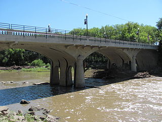
The State Street Bridge in Erie, Kansas brings State Street over a tributary of the Neosho River. It is a reinforced concrete arch bridge which was built in 1924. It was listed on the National Register of Historic Places in 1985.
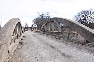
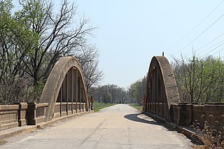
The Conroe Bridge, also known as Clark's Creek Bridge, is a Rainbow Arch bridge over Clark's Creek near Junction City, Kansas which was built in 1925. It was listed on the National Register of Historic Places in 1983.

The Brush Creek Bridge, near Coyville, Kansas, was built in 1930. It was listed on the National Register of Historic Places in 1985.

The Bucher Bridge, located off U.S. Route 77 near the town of Rock in Cowley County, Kansas, was listed on the National Register of Historic Places in 1985. It is located about 1.5 miles (2.4 km) north and 1.75 miles (2.82 km) west of Rock.

Esch's Spur Bridge is a triple span stone arch bridge which crosses Grouse Creek near Dexter, Kansas. It is 182 feet (55 m) long and 13 feet (4.0 m) wide.

The Cedar Creek Bridge near Elgin, Kansas, on FAS 96, was built in 1927. Also known as Elgin Cedar Creek Bridge, it was listed on the National Register of Historic Places in 1983.

The Neosho River Bridge, near Hartford, Kansas, was built in 1926. It was listed on the National Register of Historic Places in 1983.
The T. S. Haun House, on Main St. in Jetmore, Kansas, was built in 1879. It was listed on the National Register of Historic Places in 1973.
The Cottonwood River Bridge is a historic bridge across the Cottonwood River at the north edge of Cottonwood Falls, Kansas. The bridge was built in 1914 by the Missouri Valley Bridge and Iron Company, who bid $13,700 for its contract. It is 207 feet (63 m) long and rises 25.5 feet (7.8 m) above the river. Lead builder F. L. Rice used a concrete spandrel arch plan for the bridge, a contemporary design which has since fallen out of use. The bridge is currently closed to vehicle traffic and is used as a fishing site for a local park.
The North Fork Solomon River Lattice Truss Bridge, now located on a golf course just southeast of Norton County, Kansas, was listed on the National Register of Historic Places in 2003 when at its original location on a road near Lenora, Kansas, and its registration was updated in 2008 to address its relocation.

