Hanceville, Alabama

Last updated

Hanceville, Alabama
City of Hanceville
Flag of Hanceville, Alabama.png
Seal of Hanceville, Alabama.png
Motto(s): 
"A Positive and Progressive Community"
Cullman County Alabama Incorporated and Unincorporated areas Hanceville Highlighted 0132968.svg
Location of Hanceville in Cullman County, Alabama.
Coordinates: 34°3′48″N86°45′39″W / 34.06333°N 86.76083°W / 34.06333; -86.76083
Country United States
State Alabama
County Cullman
Government
   Mayor Kenneth Nail
Area
[1]
  Total4.39 sq mi (11.36 km2)
  Land4.37 sq mi (11.32 km2)
  Water0.01 sq mi (0.04 km2)
Elevation
[2]
548 ft (167 m)
Population
 (2020)
  Total3,217
  Density735.99/sq mi (284.17/km2)
Time zone UTC-6 (Central (CST))
  Summer (DST) UTC-5 (CDT)
ZIP code
35077
Area code 256
FIPS code 01-32968
GNIS feature ID2403793 [2]
Website cityofhanceville.net

Hanceville is a city in Cullman County, Alabama, United States. At the 2020 census, the population was 3,217. [3]

Contents

History

Founded in Blount County, Hanceville was established in 1832 and incorporated in May 1879. At the time of Cullman County's creation in 1877, half of Hanceville resided in each county. In 1885, county boundaries were redrawn and all of Hanceville was placed within Blount County. In 1901, county boundaries were redrawn again and this time all of the town was placed within Cullman County, in which it has remained. [4]

Geography

Hanceville is located in southeastern Cullman County at 34°3′48″N86°45′39″W / 34.06333°N 86.76083°W / 34.06333; -86.76083 (34.063463, -86.760908). [5] U.S. Route 31 passes through the city, leading north 9 miles (14 km) to Cullman, the county seat, and south 14 miles (23 km) to Smoke Rise.

According to the U.S. Census Bureau, the city has a total area of 4.2 square miles (10.9 km2), of which 0.02 square miles (0.04 km2), or 0.34%, is water. [6]

Climate

Climate data for Hanceville, Alabama, 1991–2020 normals, extremes 2003present
MonthJanFebMarAprMayJunJulAugSepOctNovDecYear
Record high °F (°C)77
(25)
80
(27)
88
(31)
91
(33)
94
(34)
100
(38)
100
(38)
106
(41)
97
(36)
97
(36)
87
(31)
76
(24)
106
(41)
Mean maximum °F (°C)69.9
(21.1)
72.7
(22.6)
79.5
(26.4)
83.9
(28.8)
88.7
(31.5)
93.4
(34.1)
95.3
(35.2)
95.3
(35.2)
91.6
(33.1)
85.9
(29.9)
76.5
(24.7)
70.8
(21.6)
97.0
(36.1)
Mean daily maximum °F (°C)50.9
(10.5)
55.1
(12.8)
63.5
(17.5)
71.7
(22.1)
78.5
(25.8)
85.0
(29.4)
88.2
(31.2)
88.1
(31.2)
83.4
(28.6)
72.9
(22.7)
62.2
(16.8)
53.5
(11.9)
71.1
(21.7)
Daily mean °F (°C)40.3
(4.6)
43.6
(6.4)
51.4
(10.8)
58.9
(14.9)
66.7
(19.3)
74.0
(23.3)
77.7
(25.4)
77.1
(25.1)
71.8
(22.1)
60.3
(15.7)
49.4
(9.7)
42.7
(5.9)
59.5
(15.3)
Mean daily minimum °F (°C)29.7
(−1.3)
32.1
(0.1)
39.3
(4.1)
46.2
(7.9)
54.9
(12.7)
63.1
(17.3)
67.2
(19.6)
66.0
(18.9)
60.2
(15.7)
47.7
(8.7)
36.7
(2.6)
31.8
(−0.1)
47.9
(8.9)
Mean minimum °F (°C)13.0
(−10.6)
17.5
(−8.1)
23.1
(−4.9)
31.3
(−0.4)
41.5
(5.3)
54.5
(12.5)
59.7
(15.4)
58.8
(14.9)
46.9
(8.3)
31.7
(−0.2)
20.9
(−6.2)
18.4
(−7.6)
11.5
(−11.4)
Record low °F (°C)3
(−16)
5
(−15)
16
(−9)
26
(−3)
34
(1)
51
(11)
51
(11)
49
(9)
39
(4)
24
(−4)
14
(−10)
5
(−15)
3
(−16)
Average precipitation inches (mm)5.81
(148)
5.77
(147)
5.78
(147)
5.57
(141)
4.91
(125)
4.73
(120)
4.67
(119)
3.86
(98)
3.89
(99)
3.58
(91)
4.58
(116)
5.83
(148)
58.98
(1,499)
Average snowfall inches (cm)0.2
(0.51)
0.3
(0.76)
0.5
(1.3)
0.0
(0.0)
0.0
(0.0)
0.0
(0.0)
0.0
(0.0)
0.0
(0.0)
0.0
(0.0)
0.0
(0.0)
0.0
(0.0)
0.1
(0.25)
1.1
(2.82)
Average precipitation days (≥ 0.01 in)9.29.19.88.28.99.19.97.96.06.07.49.4100.9
Average snowy days (≥ 0.1 in)0.30.30.10.00.00.00.00.00.00.00.00.10.8
Source 1: NOAA [7]
Source 2: National Weather Service (mean maxima/minima 20062020) [8]

Demographics

Historical population
CensusPop.Note
1880 150
1910 464
1920 441−5.0%
1930 78076.9%
1940 650−16.7%
1950 77519.2%
1960 1,17451.5%
1970 2,02772.7%
1980 2,2209.5%
1990 2,2461.2%
2000 2,95131.4%
2010 2,9821.1%
2020 3,2177.9%
U.S. Decennial Census [9]
2013 Estimate [10]

At the 2000 census there were 2,951 people, 1,167 households, and 710 families living in the city. The population density was 718.6 inhabitants per square mile (277.5/km2). There were 1,323 housing units at an average density of 322.2 per square mile (124.4/km2). The racial makeup of the city was 93.09% White, 4.61% Black or African American, 0.61% Native American, 0.07% Asian, 0.03% Pacific Islander, 0.75% from other races, and 0.85% from two or more races. 2.30% of the population were Hispanic or Latino of any race. [11] Of the 1,167 households 24.0% had children under the age of 18 living with them, 45.8% were married couples living together, 11.5% had a female householder with no husband present, and 39.1% were non-families. 32.6% of households were one person and 12.1% were one person aged 65 or older. The average household size was 2.23 and the average family size was 2.84.

The age distribution was 17.8% under the age of 18, 17.7% from 18 to 24, 22.0% from 25 to 44, 21.2% from 45 to 64, and 21.3% 65 or older. The median age was 38 years. For every 100 females, there were 87.5 males. For every 100 females age 18 and over, there were 80.8 males.

The median household income was $26,351 and the median family income was $35,370. Males had a median income of $31,439 versus $18,112 for females. The per capita income for the city was $13,371. About 12.5% of families and 21.9% of the population were below the poverty line, including 28.9% of those under age 18 and 13.5% of those age 65 or over.

2010 census

At the 2010 census there were 2,982 people, 1,233 households, and 691 families living in the city. The population density was 733 inhabitants per square mile (283/km2). There were 1,439 housing units at an average density of 340.2 per square mile (131.4/km2). The racial makeup of the city was 92.4% White, 3.6% Black or African American, 0.2% Native American, 0.7% Asian, 0.0% Pacific Islander, 1.4% from other races, and 1.6% from two or more races. 2.4% of the population were Hispanic or Latino of any race. [12] Of the 1,233 households 23.3% had children under the age of 18 living with them, 38.1% were married couples living together, 13.6% had a female householder with no husband present, and 44.0% were non-families. 37.1% of households were one person and 17.0% were one person aged 65 or older. The average household size was 2.26 and the average family size was 2.98.

The age distribution was 21.6% under the age of 18, 10.9% from 18 to 24, 22.5% from 25 to 44, 22.1% from 45 to 64, and 22.8% 65 or older. The median age was 40.0 years. For every 100 females, there were 83.1 males. For every 100 females age 18 and over, there were 95.2 males.

The median household income was $30,903 and the median family income was $45,560. Males had a median income of $34,338 versus $35,417 for females. The per capita income for the city was $16,078. About 14.5% of families and 24.2% of the population were below the poverty line, including 28.1% of those under age 18 and 9.8% of those age 65 or over.

2020 census

Hanceville racial composition [13]
RaceNum.Perc.
White (non-Hispanic)2,78686.6%
Black or African American (non-Hispanic)1223.79%
Native American 180.56%
Asian 130.4%
Other/Mixed 1273.95%
Hispanic or Latino 1514.69%

As of the 2020 United States census, there were 3,217 people, 1,263 households, and 730 families residing in the city. The population density was 789 inhabitants per square mile (305/km2). Of the 1,233 households 23.3% had children under the age of 18 living with them, 38.1% were married couples living together, 13.6% had a female householder with no husband present, and 44.0% were non-families. 37.1% of households were one person and 17.0% were one person aged 65 or older. The average household size was 2.26 and the average family size was 2.98.

The age distribution was 21.6% under the age of 18, 10.9% from 18 to 24, 22.5% from 25 to 44, 22.1% from 45 to 64, and 22.8% 65 or older. The median age was 47.7 years. For every 100 females, there were 83.1 males. For every 100 females age 18 and over, there were 95.2 males.

The average household income in Hanceville is $49,660 with a poverty rate of 19.00%. The median rental costs in recent years comes to $668 per month, and the median house value is $99,900. The median age in Hanceville is 47.7 years, 41.8 years for males, and 49.9 years for females.

The Shrine of the Most Blessed Sacrament Shrine of the Most Blessed Sacrament.jpg
The Shrine of the Most Blessed Sacrament

Attractions

Hanceville is home to Our Lady of the Angels Monastery. The construction began in 1996 and was completed in 1999, under the direction of Mother Angelica of the Eternal Word Television Network (EWTN).[ citation needed ]

Hanceville is also home to Alabama's oldest paintball and airsoft field, Mount Doom Paintball Field. It has been in operation since the 1980s.[ citation needed ]

Education

Hanceville High School serves 342 students in grades 9–12. The school colors are purple and gold, and its mascot are the Bulldogs. It is a member of the Cullman County Board of Education. [14] In 2001 the Lady Bulldogs basketball team won the Alabama High School Athletic Association Class 3A State Championship. [15]

Colleges and universities

Wallace State Community College is the only college in the city. It opened in 1966 and has approximately 6,000 students. [16]

Laws

Hanceville, Alabama gained some media coverage when it passed a law to prevent transgender people from using the restroom of their unnatural gender. [17]

Notable people

Related Research Articles

<span class="mw-page-title-main">Winston County, Alabama</span> County in Alabama, United States

Winston County is a county of the U.S. state of Alabama. As of the 2020 census, the population was 23,540. Its county seat is Double Springs. Known as Hancock County before 1858, the county is named in honor of John A. Winston, the fifteenth Governor of Alabama.

<span class="mw-page-title-main">Morgan County, Alabama</span> County in Alabama, United States

Morgan County is a county in the north-central part of the U.S. state of Alabama. As of the 2020 census, its population was 123,421. The county seat is Decatur. On June 14, 1821, it was renamed in honor of American Revolutionary War General Daniel Morgan of Virginia. It is a prohibition or dry county, although alcohol sales are allowed in the cities of Decatur, Hartselle, and Priceville. Morgan County is included in the Decatur, AL Metropolitan Statistical Area, which is also included in the Huntsville-Decatur-Albertville, AL Combined Statistical Area. It is a part of the North, Northwest, and North-Central regions of Alabama.

<span class="mw-page-title-main">Cullman County, Alabama</span> County in Alabama, United States

Cullman County is a county located in the north central portion of the U.S. state of Alabama. As of the 2020 census, the population was 87,866. Its county seat and largest city is Cullman. Its name is in honor of Colonel John G. Cullmann.

<span class="mw-page-title-main">Lawrence County, Alabama</span> County in Alabama, United States

Lawrence County is a county in the northern part of the U.S. state of Alabama. As of the 2020 census, the population was 33,073. The county seat is Moulton. The county was named after James Lawrence, a captain in the United States Navy from New Jersey.

<span class="mw-page-title-main">Marshall County, Alabama</span> County in Alabama, United States

Marshall County is a county of the state of Alabama, United States. As of the 2020 census the population was 97,612. Its county seat is Guntersville. A second courthouse is in Albertville. Its name is in honor of John Marshall, famous Chief Justice of the United States. Marshall County is a dry county, with the exception of the five cities of Albertville, Arab, Grant, Guntersville, and Boaz. Marshall County comprises the Albertville, AL Micropolitan Statistical Area, which is also included in the Huntsville-Decatur-Albertville, AL Combined Statistical Area.

<span class="mw-page-title-main">Walker County, Alabama</span> County in Alabama, United States

Walker County is a county located in the central portion of the U.S. state of Alabama. As of the 2020 census, the population was 65,342. Its county seat is Jasper. Its name is in honor of John Williams Walker, the first U.S. senator elected from Alabama.

<span class="mw-page-title-main">Garden City, Alabama</span> Town in Alabama, United States

Garden City is a town in Cullman and Blount counties in the U.S. state of Alabama. At the 2020 census, the population was 528. Garden City was founded by Johann Cullmann, namesake of Cullman County in 1873 after founding Cullman, Alabama. It was located in Blount County and was incorporated in 1878. Cullman County was created in 1877. Garden City was annexed by Cullman County with a shift in county borders until 1901. After a lapse in its incorporation, it was re-incorporated in 1950.

<span class="mw-page-title-main">Arab, Alabama</span> City in Alabama, United States

Arab is a city in Marshall County in the northern part of the U.S. state of Alabama, located 10 miles (16 km) from Guntersville Lake and Guntersville Dam, and is included in the Huntsville-Decatur Combined Statistical Area. The population was 8,461 at the 2020 census.

<span class="mw-page-title-main">Baileyton, Alabama</span> Town in Alabama, United States

Baileyton is a town in Cullman County, Alabama, United States. At the 2020 census, the population was 649.

<span class="mw-page-title-main">Colony, Alabama</span> Town in Alabama, United States

Colony is a town in Cullman County, Alabama, United States. At the 2010 census the population was 268, down from 385 in 2000. Colony is a historically African-American town. In its early days it was a haven for African Americans in the Deep South. It incorporated in 1981.

<span class="mw-page-title-main">Cullman, Alabama</span> City in and county seat of Cullman County, Alabama

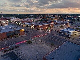
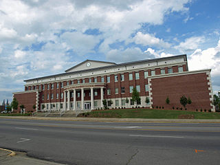
Cullman is the largest city and county seat of Cullman County, Alabama, United States. It is located along Interstate 65, about 50 miles (80 km) north of Birmingham and about 55 miles (89 km) south of Huntsville. As of the 2020 census it had a population of 18,213, with an estimated population of 19,251 in 2022.

<span class="mw-page-title-main">Dodge City, Alabama</span> Town in Alabama, United States

Dodge City is a town in Cullman County, Alabama, United States. At the 2020 census, the population was 548. It was incorporated in 1993.

<span class="mw-page-title-main">Fairview, Alabama</span> Town in Alabama, United States

Fairview is a town in Cullman County, Alabama, United States. At the 2010 census the population was 446, down from 522 in 2000. It incorporated in 1968.

<span class="mw-page-title-main">Good Hope, Alabama</span> City in Alabama, United States

Good Hope is a city in Cullman County, Alabama, United States. As of the 2010 census, the population of the city was 2,264. It incorporated in April 1962.

<span class="mw-page-title-main">Holly Pond, Alabama</span> Town in Alabama, United States

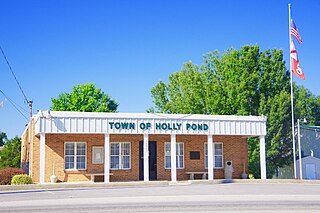
Holly Pond is a town in Cullman County, Alabama, United States. As of the 2010 census the town's population was 798. The town was incorporated in 1906.

<span class="mw-page-title-main">South Vinemont, Alabama</span> Town in Alabama, United States

South Vinemont is a town in Cullman County, Alabama, United States. At the 2010 census the population was 749, up from 425 in 2000.

<span class="mw-page-title-main">West Point, Alabama</span> Town in Alabama, United States

West Point is a town in Cullman County, Alabama, United States. The population was 584 at the 2020 census. West Point was incorporated on October 15, 1977.

<span class="mw-page-title-main">Clay, Alabama</span> City in Alabama, United States

Clay is a city in northeastern Jefferson County, Alabama, United States. It is part of the Birmingham–Hoover–Cullman Combined Statistical Area in the north-central part of the state. Local government is run by a mayor and city council.

<span class="mw-page-title-main">Hartselle, Alabama</span> City in Alabama, United States

Hartselle is the second largest city in Morgan County, Alabama, United States, 13 miles (21 km) south of Decatur. It is part of the Decatur Metropolitan Area and the Huntsville-Decatur Combined Statistical Area.

<span class="mw-page-title-main">Steele, Alabama</span> Town in Alabama, United States

Steele is a town in northeastern St. Clair County, Alabama, United States. It was incorporated in 1952. At the 2010 census the population was 1,043, down from 1,093. The town is a part of the Birmingham–Hoover–Cullman Combined Statistical Area. It was initially known as Steel's Station or Steele's Depot in the late 19th century.

References

  1. "2020 U.S. Gazetteer Files". United States Census Bureau. Retrieved October 29, 2021.
  2. 1 2 U.S. Geological Survey Geographic Names Information System: Hanceville, Alabama
  3. "Hanceville, Alabama Population 2021 (Demographics, Maps, Graphs)".
  4. "Hanceville". Encyclopedia of Alabama. Retrieved August 6, 2019.
  5. "US Gazetteer files: 2010, 2000, and 1990". United States Census Bureau. February 12, 2011. Retrieved April 23, 2011.
  6. "Geographic Identifiers: 2010 Demographic Profile Data (G001): Hanceville city, Alabama (revised 07-02-2012)". U.S. Census Bureau, American Factfinder. Archived from the original on February 12, 2020. Retrieved June 11, 2014.
  7. "U.S. Climate Normals Quick Access – Station: Hanceville, AL". National Oceanic and Atmospheric Administration. Retrieved March 4, 2023.
  8. "NOAA Online Weather Data – NWS Huntsville". National Weather Service. Retrieved March 4, 2023.
  9. "U.S. Decennial Census". Census.gov. Retrieved June 6, 2013.
  10. "Annual Estimates of the Resident Population: April 1, 2010 to July 1, 2013". Archived from the original on May 22, 2014. Retrieved June 3, 2014.
  11. "U.S. Census website". United States Census Bureau . Retrieved January 31, 2008.
  12. "U.S. Census website". United States Census Bureau . Retrieved July 20, 2015.
  13. "Explore Census Data". data.census.gov. Retrieved December 18, 2021.
  14. Cullman County Board of Education
  15. Champions
  16. "Parents | Wallace State Community College". www.wallacestate.edu. Retrieved August 6, 2019.
  17. "Hanceville City Council Meets; Transgender Restroom Ordinance to be Considered". April 29, 2016.
  18. "Bill Steltemeier, EWTN Founding President, Dies, 83; Deacon Served Network Since 1980". Multichannel News . February 15, 2013. Retrieved February 24, 2013.