Hanksville, Utah

Last updated

Hanksville, Utah
Town
Hollow Mountain.jpg
Hollow Mountain Store
Wayne County Utah incorporated and unincorporated areas Hanksville highlighted.svg
Location in Wayne County and the state of Utah.
Coordinates: 38°22′17″N110°42′47″W / 38.37139°N 110.71306°W / 38.37139; -110.71306
Country United States
State Utah
County Wayne
Settled1882
Incorporated January 6, 1999
Named for Ebenezer Hanks
Area
[1]
  Total1.72 sq mi (4.45 km2)
  Land1.69 sq mi (4.36 km2)
  Water0.03 sq mi (0.09 km2)
Elevation
[2]
4,295 ft (1,309 m)
Population
 (2010)
  Total219
  Estimate 
(2019) [3]
220
  Density130.56/sq mi (50.42/km2)
Time zone UTC-7 (Mountain (MST))
  Summer (DST) UTC-6 (MDT)
ZIP codes
84734
Area code 435
FIPS code 49-33100
GNIS feature ID2412723 [2]
Website www.hanksvilleutah.gov

Hanksville is a small town in Wayne County, Utah, United States, at the junction of State Routes 24 and 95. The population was 219 at the 2010 census. [4]

Contents

Situated in the Colorado Plateau's cold desert ecological region, the town is just south of the confluence of the Fremont River and Muddy Creek, which together form the Dirty Devil River, which then flows southeast to the Colorado River. The Hanksville-Burpee Quarry is located nearby, and the Mars Desert Research Station is 7 miles (11 km) northwest of town. The Bureau of Land Management's Henry Mountains field station is located in Hanksville. [5]

History

Dirty Devil River in 1954, near crossover by Poison Springs Wash Road in Hanksville, Utah DirtyDevilRiver1954.jpg
Dirty Devil River in 1954, near crossover by Poison Springs Wash Road in Hanksville, Utah

The town was settled in 1882 and known for a time for the name given to the surrounding area, Graves Valley. It took the name of Hanksville in 1885, after Ebenezer Hanks, an early settler. [6] It was incorporated in 1999. [7]

The Rural Electrification Administration brought electricity to the community in 1960. Today agriculture, mining, and tourism are the main drivers to the local economy. Tourism is particularly important with people coming for recreation at Lake Powell, Capitol Reef National Park, the Henry Mountains, the San Rafael Swell, Goblin Valley State Park, Factory Butte, and the solitude of the surrounding deserts and slot canyons.

Hanksville was a supply post for Butch Cassidy and the Wild Bunch, who would hide out at Robbers Roost in the desert southeast of town.

During the uranium mining frenzy following World War II, Hanksville became a supply center for the prospectors and miners scouring the deserts of the Colorado Plateau. Many abandoned mines can be found in the deserts surrounding the town.

Demographics

Historical population
CensusPop.Note
1890 81
1900 46−43.2%
1910 7767.4%
1920 14183.1%
1930 81−42.6%
1940 12959.3%
1950 1290.0%
1960 16931.0%
1970 1817.1%
1980 35193.9%
1990 324−7.7%
2000 36211.7%
2010 219−39.5%
2019 (est.)220 [3] 0.5%
U.S. Decennial Census [8]

As of the 2010 census, 219 people lived in the town. There were 94 housing units. The racial makeup of the town was 98.2% White, 0.5% Asian, and 1.4% from two or more races. Hispanic or Latino of any race were 0.9% of the population. [9]

Climate

According to the Köppen climate classification system, Hanksville has a semi-arid climate, abbreviated "BSk" on climate maps. [10] It has a mean annual temperature of 53.9 °F (12.2 °C) and an annual mean rainfall of 6.16 inches (156.5 mm). [11]

Climate data for Hanksville, Utah, 1991–2020 normals, extremes 1910–2022
MonthJanFebMarAprMayJunJulAugSepOctNovDecYear
Record high °F (°C)69
(21)
75
(24)
88
(31)
98
(37)
107
(42)
110
(43)
114
(46)
110
(43)
105
(41)
97
(36)
82
(28)
70
(21)
114
(46)
Mean maximum °F (°C)57.4
(14.1)
65.3
(18.5)
78.8
(26.0)
87.5
(30.8)
96.9
(36.1)
104.4
(40.2)
108.0
(42.2)
104.3
(40.2)
98.5
(36.9)
88.2
(31.2)
70.4
(21.3)
57.4
(14.1)
108.4
(42.4)
Mean daily maximum °F (°C)43.1
(6.2)
51.2
(10.7)
63.8
(17.7)
70.8
(21.6)
81.1
(27.3)
93.4
(34.1)
98.7
(37.1)
95.2
(35.1)
86.3
(30.2)
71.5
(21.9)
55.7
(13.2)
42.9
(6.1)
71.1
(21.8)
Daily mean °F (°C)29.1
(−1.6)
36.2
(2.3)
46.4
(8.0)
53.1
(11.7)
62.8
(17.1)
73.1
(22.8)
79.8
(26.6)
76.8
(24.9)
67.1
(19.5)
53.3
(11.8)
39.7
(4.3)
29.0
(−1.7)
53.9
(12.1)
Mean daily minimum °F (°C)15.2
(−9.3)
21.1
(−6.1)
28.9
(−1.7)
35.3
(1.8)
44.4
(6.9)
52.7
(11.5)
60.9
(16.1)
58.3
(14.6)
47.9
(8.8)
35.1
(1.7)
23.6
(−4.7)
15.0
(−9.4)
36.5
(2.5)
Mean minimum °F (°C)1.2
(−17.1)
6.8
(−14.0)
16.4
(−8.7)
23.6
(−4.7)
33.1
(0.6)
42.1
(5.6)
51.1
(10.6)
48.8
(9.3)
35.7
(2.1)
22.0
(−5.6)
10.7
(−11.8)
2.6
(−16.3)
−2.3
(−19.1)
Record low °F (°C)−35
(−37)
−33
(−36)
4
(−16)
10
(−12)
23
(−5)
31
(−1)
38
(3)
35
(2)
24
(−4)
−6
(−21)
−8
(−22)
−24
(−31)
−35
(−37)
Average precipitation inches (mm)0.40
(10)
0.39
(9.9)
0.47
(12)
0.45
(11)
0.43
(11)
0.23
(5.8)
0.71
(18)
0.57
(14)
0.83
(21)
0.87
(22)
0.47
(12)
0.34
(8.6)
6.16
(155.3)
Average snowfall inches (cm)2.5
(6.4)
1.1
(2.8)
0.5
(1.3)
0.0
(0.0)
0.0
(0.0)
0.0
(0.0)
0.0
(0.0)
0.0
(0.0)
0.0
(0.0)
0.1
(0.25)
0.6
(1.5)
2.5
(6.4)
7.3
(18.65)
Average precipitation days (≥ 0.01 in)4.24.44.03.73.72.34.55.34.74.12.83.647.3
Average snowy days (≥ 0.1 in)1.40.60.30.00.00.00.00.00.00.10.51.64.5
Source 1: NOAA [11]
Source 2: National Weather Service [12]

See also

Related Research Articles

<span class="mw-page-title-main">Cottonwood, Colorado</span> Neighborhood in Douglas County, State of Colorado, United States

Cottonwood is a neighborhood in the Town of Parker, Colorado. A former census-designated place (CDP), the population was 931 at the 2000 census.

<span class="mw-page-title-main">Ponderosa Park, Colorado</span> Census Designated Place in Colorado, United States

Ponderosa Park is an unincorporated community and a census-designated place (CDP) located in and governed by Elbert County, Colorado, United States. The CDP is a part of the Denver–Aurora–Lakewood, CO Metropolitan Statistical Area. The population of the Ponderosa Park CDP was 3,334 at the United States Census 2020. Elbert County governs the unincorporated community. The Elizabeth post office serves the area.

<span class="mw-page-title-main">Collbran, Colorado</span> Town in Mesa County, Colorado, United States

Collbran is a statutory town located in Mesa County, Colorado, United States. The town's population was 369 at the 2020 Census. Collbran is a part of the Grand Junction, CO Metropolitan Statistical Area.

<span class="mw-page-title-main">Henrieville, Utah</span> Town in the state of Utah, United States

Henrieville is a town in Garfield County, Utah, United States, along Utah Scenic Byway 12. As of the 2020 census, the town population was 221.

<span class="mw-page-title-main">Levan, Utah</span> Town in Juab County, Utah, United States

Levan is a town in Juab County, Utah, United States. As of the 2020 census it had a population of 862.

<span class="mw-page-title-main">Circleville, Utah</span> Town in the state of Utah, United States

Circleville is a town in Piute County, Utah, United States. The population was 547 at the 2010 census.

<span class="mw-page-title-main">Midvale, Utah</span> City in Utah, United States

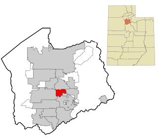
Midvale City is located in the heart of Salt Lake County, Utah, United States. It is part of the Salt Lake City metropolitan area. Midvale's population was 34,124 according to 2019 estimates from the U.S. Census Bureau.

<span class="mw-page-title-main">Blanding, Utah</span> City in Utah, United States

Blanding is a city in San Juan County, Utah, United States. The population was 3,375 at the 2010 census, making it the most populated city in San Juan County. It was settled in the late 19th century by Mormon settlers, predominantly from the famed Hole-In-The-Rock expedition. Economic contributors include mineral processing, mining, agriculture, local commerce, tourism, and transportation.

<span class="mw-page-title-main">Heber City, Utah</span> City in Utah, United States

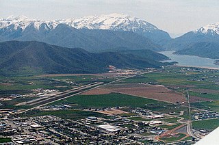
Heber City is a city and county seat of Wasatch County, Utah. The population was 16,856 as of the 2020 United States census. The city is located 43 miles southeast of Salt Lake City.

<span class="mw-page-title-main">Hildale, Utah</span> City in Utah, United States

Hildale is a city in Washington County, Utah, United States. The population was 1,127 at the 2020 census.

<span class="mw-page-title-main">Ivins, Utah</span> City in Utah, United States

Ivins is a city in southwestern Washington County, Utah, United States. It is a part of the St. George Metropolitan Area as a suburb or "bedroom" community. The population was 8,978 at the 2020 census, up from 6,753 at the 2010 census. Although Ivins was listed as a town in the 2000 census, it became a city in 1998.

<span class="mw-page-title-main">Leeds, Utah</span> Town in Washington County, Utah

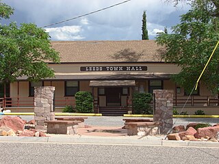
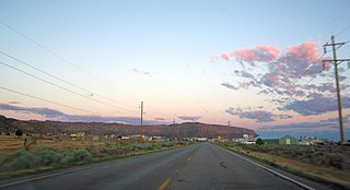
Leeds is a town in Washington County, Utah, United States. The population was 820 at the 2010 census.

<span class="mw-page-title-main">New Harmony, Utah</span> Town in the state of Utah, United States

New Harmony is a town in northern Washington County, Utah, United States. The population was 207 at the 2010 census.

<span class="mw-page-title-main">Green River, Utah</span> City in Utah, United States

Green River is a city in Emery County, Utah, United States. The population was 847 at the 2020 census.

<span class="mw-page-title-main">Dyer, Nevada</span> Census-designated place in Nevada, United States

Dyer is an unincorporated town, located in Fish Lake Valley, Esmeralda County, Nevada, United States. It had a population of 324 as of the 2018 American Community Survey. The town serves the surrounding area's sparse rural population of mainly ranchers and indigenous Paiute people. The town has a gas station/store, cafe, post office and airport.

<span class="mw-page-title-main">Whitewater, California</span> Census-Designated Place in California, United States

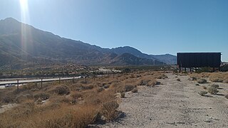
Whitewater is a census-designated place in Riverside County, California. It is directly off Interstate 10 halfway between North Palm Springs and Cabazon on the way from Palm Springs to Los Angeles. It is known as the site of the San Gorgonio Pass Wind Farm. The ZIP Code is 92282, and the community is inside area code 760. The population was 859 at the 2010 census. The elevation is 1,575 feet (480 m).

<span class="mw-page-title-main">Chloride, Arizona</span> Census-designated place in Mohave County

Chloride is a onetime silver mining camp in Mohave County, Arizona, United States, and is considered the oldest continuously inhabited mining town in the state. The town is a census-designated place (CDP), with a population at the 2020 census of 229. Chloride has a ZIP Code of 86431.

<span class="mw-page-title-main">Geography of Arizona</span>

Arizona is a landlocked state situated in the southwestern region of the United States of America. It has a vast and diverse geography famous for its deep canyons, high- and low-elevation deserts, numerous natural rock formations, and volcanic mountain ranges. Arizona shares land borders with Utah to the north, the Mexican state of Sonora to the south, New Mexico to the east, and Nevada to the northwest, as well as water borders with California and the Mexican state of Baja California to the southwest along the Colorado River. Arizona is also one of the Four Corners states and is diagonally adjacent to Colorado.

<span class="mw-page-title-main">Mountain states</span> Region of the United States

The Mountain states form one of the nine geographic divisions of the United States that are officially recognized by the United States Census Bureau. It is a subregion of the Western United States.

<span class="mw-page-title-main">Bull Mountain (Garfield County, Utah)</span> Mountain in the American state of Utah

Bull Mountain is a 9,187-foot elevation summit located in northern Garfield County of Utah, United States. Bull Mountain is part of the Henry Mountains which are set between Capitol Reef National Park to the west, and Glen Canyon National Recreation Area to the east. Mount Ellen is immediately southwest of Bull Mountain, and Burr Desert spreads out to the northeast. It is situated in a dry, rugged, and sparsely settled region, set on primitive land administered by the Bureau of Land Management. Precipitation runoff from this mountain drains into tributaries of the Colorado River. The nearest town is Hanksville, 17 miles to the north, and Robbers Roost is 20 miles to the northeast.

References

  1. "2019 U.S. Gazetteer Files". United States Census Bureau. Retrieved August 7, 2020.
  2. 1 2 U.S. Geological Survey Geographic Names Information System: Hanksville
  3. 1 2 "Population and Housing Unit Estimates". United States Census Bureau. May 24, 2020. Retrieved May 27, 2020.
  4. "Geographic Identifiers: 2010 Demographic Profile Data (G001): Hanksville town, Utah". U.S. Census Bureau, American Factfinder. Archived from the original on February 12, 2020. Retrieved February 4, 2013.
  5. "Henry Mountains Field Station". Archived from the original on March 4, 2016. Retrieved October 12, 2015.
  6. Van Cott, John W. (1990). Utah Place Names. Salt Lake City: University of Utah Press. p. 176. ISBN   0-87480-345-4.
  7. Geographic Change Notes: Utah Archived May 2, 2008, at the Wayback Machine , United States Census Bureau, 2007. Accessed March 4, 2009.
  8. "Census of Population and Housing". Census.gov. Retrieved June 4, 2015.
  9. "U.S. Census website". United States Census Bureau . Retrieved January 19, 2012.
  10. "Hanksville, Utah Köppen Climate Classification (Weatherbase)". Weatherbase. Retrieved February 13, 2019.
  11. 1 2 "U.S. Climate Normals Quick Access – Station: Hanksville, UT". National Oceanic and Atmospheric Administration. Retrieved February 20, 2023.
  12. "NOAA Online Weather Data – NWS Salt Lake City". National Weather Service. Retrieved February 20, 2023.

Further reading