Hannahs Mill, Georgia

Last updated

Hannahs Mill, Georgia
Upson County Georgia Incorporated and Unincorporated areas Hannahs Mill Highlighted.svg
Location in Upson County and the state of Georgia
Coordinates: 32°56′8″N84°20′17″W / 32.93556°N 84.33806°W / 32.93556; -84.33806
Country United States
State Georgia
County Upson
Area
[1]
  Total4.36 sq mi (11.28 km2)
  Land4.32 sq mi (11.19 km2)
  Water0.04 sq mi (0.09 km2)
Elevation
748 ft (228 m)
Population
 (2020)
  Total3,121
  Density722.45/sq mi (278.96/km2)
Time zone UTC-5 (Eastern (EST))
  Summer (DST) UTC-4 (EDT)
ZIP code
30286 [2]
Area code 706
FIPS code 13-36416 [3]
GNIS feature ID0331907 [4]

Hannahs Mill is an unincorporated community and census-designated place (CDP) in Upson County, Georgia, United States. The population was 3,267 at the 2000 census.

Contents

Geography

Hannahs Mill is located at 32°56′08″N84°20′17″W / 32.935572°N 84.338136°W / 32.935572; -84.338136 . [5]

According to the United States Census Bureau, the CDP has a total area of 4.4 square miles (11 km2), of which 4.4 square miles (11 km2) is land and 0.23% is water.

Demographics

Historical population
CensusPop.Note
1980 2,616
2000 3,267
2010 3,2980.9%
2020 3,121−5.4%
U.S. Decennial Census [6]
1850-1870 [7] 1870-1880 [8]
1890-1910 [9] 1920-1930 [10]
1940 [11] 1950 [12] 1960 [13]
1970 [14] 1980 [15] 1990 [16]
2000 [17] 2010 [18] 2020 [19]

Hannahs Mills first appeared as a census designated place in the 1980 U.S. census. [15] It was not listed in the 1990 U.S. census [16] after a portion of the CDP was annexed to Thomastown. [20] It reappeared as a CDP in the 2000 U.S. census.

Hannahs Mill, Georgia – Racial and ethnic composition
Note: the US Census treats Hispanic/Latino as an ethnic category. This table excludes Latinos from the racial categories and assigns them to a separate category. Hispanics/Latinos may be of any race.
Race / Ethnicity (NH = Non-Hispanic)Pop 2000 [21] Pop 2010 [18] Pop 2020 [19] % 2000% 2010% 2020
White alone (NH)2,9502,8002,54090.30%84.90%81.38%
Black or African American alone (NH)2093283246.40%9.95%10.38%
Native American or Alaska Native alone (NH)16540.49%0.15%0.13%
Asian alone (NH)2622530.80%0.67%1.70%
Pacific Islander alone (NH)0000.00%0.00%0.00%
Some Other Race alone (NH)0230.00%0.06%0.10%
Mixed race or Multiracial (NH)19451060.58%1.36%3.40%
Hispanic or Latino (any race)4796911.44%2.91%2.92%
Total3,2673,2983,121100.00%100.00%100.00%

Related Research Articles

<span class="mw-page-title-main">Lamar County, Georgia</span> County in Georgia, United States

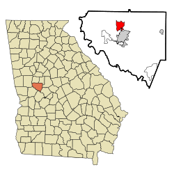
Lamar County is a county located in the west central portion of the U.S. state of Georgia. As of the 2020 census, the population was 18,500. The county seat is Barnesville.

<span class="mw-page-title-main">Kings Bay Base, Georgia</span> Place in Georgia, United States

Kings Bay Base is an unincorporated community and census-designated place (CDP) in Camden County, Georgia, United States; it is home to the Kings Bay Naval Submarine Base. The population was 1,777 at the 2010 census, and 2,329 in 2020.

<span class="mw-page-title-main">Montgomery, Georgia</span> Place in Georgia, United States

Montgomery is an unincorporated community and census-designated place (CDP) in Chatham County, Georgia, United States. The population was 4,443 at the 2020 United States census, down slightly from 4,523 in 2010. It is a suburb of Savannah and is part of the Savannah metropolitan area.

<span class="mw-page-title-main">Vinings, Georgia</span> Place in Georgia, United States

Vinings is an unincorporated community and census-designated place (CDP) in Cobb County, Georgia, United States that runs along the Chattahoochee River bank across from Buckhead. As of the 2020 census, the CDP had a total population of 12,581. Located next to the affluent Paces section of Buckhead in northwest Atlanta, Vinings is known for its historic sites, shopping districts, proximity to local freeways and The Battery, and nearby nature areas. The United States Postal Service assigns "Atlanta" to the ZIP Code (30339) that includes Vinings.

<span class="mw-page-title-main">Belvedere Park, Georgia</span> Place in Georgia, United States

Belvedere Park is an unincorporated community and census-designated place (CDP) in DeKalb County, Georgia, United States. The population was 15,113 at the 2020 census.

<span class="mw-page-title-main">Gresham Park, Georgia</span> Place in Georgia, United States

Gresham Park is an unincorporated community and census-designated place (CDP) in DeKalb County, Georgia, United States. The population was 7,700 at the 2020 census.

<span class="mw-page-title-main">Mountain Park, Gwinnett County, Georgia</span> Place in Georgia, United States

Mountain Park is an unincorporated community and census-designated place (CDP) in Gwinnett County, Georgia, United States. The population was 11,554 at the 2010 census. The older name for the area is Trickum, which is reflected in Five Forks-Trickum Road which bisects the community. The older community was centered on Five Forks and Rockbridge Roads.

<span class="mw-page-title-main">Hilltop, Georgia</span> Place in Georgia, United States

Hilltop is an unincorporated community and census-designated place (CDP) in Pike County, Georgia, United States. The population was 401 at the 2000 census.

<span class="mw-page-title-main">Coleman, Georgia</span> Place in Georgia, United States

Coleman is a former incorporated city in Randolph County, Georgia, United States. It is listed as a census-designated place (CDP). The population was 149 at the 2000 census. The city was abolished by House Bill 1102 effective January 1, 2007, and no longer exists as a municipality.

<span class="mw-page-title-main">Hiltonia, Georgia</span> City in Georgia, United States

Hiltonia is a city in Screven County, Georgia, United States. The population was 310 in 2020.

<span class="mw-page-title-main">East Griffin, Georgia</span> Place in Georgia, United States

East Griffin is an unincorporated community and census-designated place (CDP) in Spalding County, Georgia, United States. The population was 1,635 at the 2000 census.

<span class="mw-page-title-main">Experiment, Georgia</span> Place in Georgia, United States

Experiment is an unincorporated community and census-designated place (CDP) in Spalding County, Georgia, United States. The population was 3,233 at the 2000 census.

<span class="mw-page-title-main">Lincoln Park, Georgia</span> Place in Georgia, United States

Lincoln Park is an unincorporated community and census-designated place (CDP) in Upson County, Georgia, United States. The population was 1,122 at the 2000 census.

<span class="mw-page-title-main">Salem, Georgia</span> Place in Georgia, United States

Salem is an unincorporated community and census-designated place (CDP) in Upson County, Georgia, United States. The population was 310 at the 2010 census.

<span class="mw-page-title-main">Sunset Village, Georgia</span> Place in Georgia, United States

Sunset Village is an unincorporated community and census-designated place (CDP) in Upson County, Georgia, United States. The population was 871 at the 2000 census.

<span class="mw-page-title-main">Deenwood, Georgia</span> Place in Georgia, United States

Deenwood is an unincorporated community and census-designated place (CDP) in Ware County, Georgia, United States. The population was 2,207 at the 2020 census. It is part of the Waycross micropolitan statistical area. Deenwood Baptist Church is named after this geographical area.

The Rock is an unincorporated community and census-designated place in Upson County, Georgia, United States. The Rock is located on Georgia State Route 36, 7 miles (11 km) northeast of Thomaston. The Rock has a post office with ZIP code 30285, although the post office is on the list to be closed. The Rock is also home to the area-famous Rock Ranch, a small theme park with a farming theme. The Rock is bordered by the cities of Barnesville, Hannahs Mill, Meansville, and Yatesville.

Cedar Springs is an unincorporated community and census-designated place (CDP) in Early County, Georgia, United States. At the time of the 2020 census, the population was 75. Cedar Springs has a post office with ZIP code 39832. Georgia State Route 273 passes through the community. Georgia Pacific is 2 miles southwest from it.

Norristown is an unincorporated community and census-designated place (CDP) in Emanuel County, Georgia, United States. Its population was 54 as of the 2020 census.

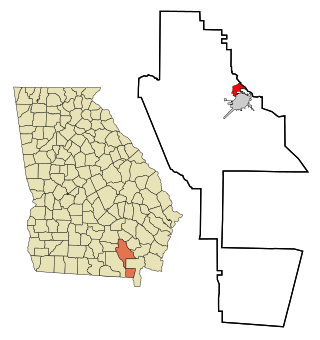
Satilla is a unincorporated community and census designated place in Jeff Davis County, Georgia, United States. Its population was 487 as of the 2020 census. U.S. Route 23 passes through the community.

References

  1. "2020 U.S. Gazetteer Files". United States Census Bureau. Retrieved December 18, 2021.
  2. "Hannahs Mill ZIP Code". zipdatamaps.com. 2023. Retrieved January 12, 2023.
  3. "U.S. Census website". United States Census Bureau . Retrieved January 31, 2008.
  4. "US Board on Geographic Names". United States Geological Survey. October 25, 2007. Retrieved January 31, 2008.
  5. "US Gazetteer files: 2010, 2000, and 1990". United States Census Bureau. February 12, 2011. Retrieved April 23, 2011.
  6. "Decennial Census of Population and Housing by Decade". United States Census Bureau.
  7. "1870 Census of Population - Georgia - Population of Civil Divisions less than Counties" (PDF). United States Census Bureau. 1870.
  8. "1880 Census of Population - Georgia - Population of Civil Divisions less than Counties" (PDF). United States Census Bureau. 1880.
  9. "1910 Census of Population - Georgia" (PDF). United States Census Bureau. 1930.
  10. "1930 Census of Population - Georgia" (PDF). United States Census Bureau. 1930. pp. 251–256.
  11. "1940 Census of Population - Georgia" (PDF). United States Census Bureau. 1940.
  12. "1950 Census of Population - Georgia" (PDF). United States Census Bureau. 1980.
  13. "1960 Census of Population - Population of County Subdivisions - Georgia" (PDF). United States Census Bureau. 1960.
  14. "1970 Census of Population - Population of County Subdivisions - Georgia" (PDF). United States Census Bureau. 1970.
  15. 1 2 "1980 Census of Population - Number of Inhabitants - Georgia" (PDF). United States Census Bureau. 1980.
  16. 1 2 "1990 Census of Population - Summary Social, Economic, and Housing Characteristics - Georgia" (PDF). United States Census Bureau. 1990.
  17. "2000 Census of Population - General Population Characteristics - Georgia" (PDF). United States Census Bureau. 2000.
  18. 1 2 "P2: Hispanic or Latino, and Not Hispanic or Latino by Race – 2010: DEC Redistricting Data (PL 94-171) – Hannahs Mill CDP, Georgia". United States Census Bureau. Retrieved January 26, 2024.
  19. 1 2 "P2: Hispanic or Latino, and Not Hispanic or Latino by Race – 2020: DEC Redistricting Data (PL 94-171) – Hannahs Mill CDP, Georgia". United States Census Bureau. Retrieved January 26, 2024.
  20. "1990 Census of Population - Population and Housing - Georgia" (PDF). United States Census Bureau. 1990. p. III-4. Upson County—Annexations: Thomaston city, Yatesville town. Deleted CDP's: Hannahs Mill and Lincoln Park (both partially annexed by Thomaston city).
  21. "P004 HISPANIC OR LATINO, AND NOT HISPANIC OR LATINO BY RACE – 2000: DEC Summary File 1 – Hannahs Mill CDP, Georgia". United States Census Bureau. Retrieved January 26, 2024.