Hanover, Illinois

Last updated
Hanover
Hanover, Ill - Rocky Waters 05.jpg
Nicknames: 
Mallard Capital of the World [1]
Gateway to Jo Daviess County Hills [1]
Jo Daviess County Illinois Incorporated and Unincorporated areas Hanover Highlighted.svg
Location of Hanover in Jo Daviess County, Illinois.
Illinois in United States (US48).svg
Location of Illinois in the United States
Coordinates: 42°15′22″N90°16′50″W / 42.25611°N 90.28056°W / 42.25611; -90.28056 Coordinates: 42°15′22″N90°16′50″W / 42.25611°N 90.28056°W / 42.25611; -90.28056
CountryUnited States
StateIllinois
County Jo Daviess
Township Hanover
Government
  Village PresidentDon Schaible
Area
[2]
  Total1.12 sq mi (2.91 km2)
  Land1.12 sq mi (2.91 km2)
  Water0.00 sq mi (0.00 km2)
Elevation
[3]
627 ft (191 m)
Population
 (2020)
  Total863
  Density769.16/sq mi (296.91/km2)
Time zone UTC-6 (CST)
  Summer (DST) UTC-5 (CDT)
ZIP Code(s)
61041
Area code 815
FIPS code 17-32707
Wikimedia CommonsHanover, Illinois
Website http://www.hanover-il.com/

Hanover is a village in Jo Daviess County, Illinois, United States, along the Apple River. The town was previously named Wapello, in honor of Chief Wapello of the Meskwaki tribe. [4] The population was 844 at the 2010 census, up from 836 in 2000.

Contents

Geography

Hanover is located at 42°15′22″N90°16′50″W / 42.25611°N 90.28056°W / 42.25611; -90.28056 (42.256058, -90.280674). [5]

According to the 2010 census, the village has a total area of 1.05 square miles (2.7 km2), all land. [6] Hanover sits in the northwest corner of Illinois, within five miles of the Mississippi River. Illinois Route 84, part of the scenic Great River Road, passes through the center of town. The Apple River, a tributary of the Mississippi, winds through and around Hanover.

Demographics

Historical population
CensusPop.Note
1880 459
1890 74361.9%
1900 7855.7%
1910 650−17.2%
1920 73713.4%
1930 8069.4%
1940 89911.5%
1950 1,64382.8%
1960 1,396−15.0%
1970 1,243−11.0%
1980 1,069−14.0%
1990 908−15.1%
2000 836−7.9%
2010 8441.0%
2020 8632.3%
U.S. Decennial Census [7]

As of the census [8] of 2000, there were 836 people, 394 households, and 230 families residing in the village. The population density was 1,411.2 people per square mile (544.9 people/km2). There were 441 housing units at an average density of 744.4 per square mile (287.4/km2). The racial makeup of the village was 97.01% White, 1.24% African American, 0.24% Native American, 0.12% Asian, 0.72% from other races, and 0.67% from two or more races. Hispanic or Latino of any race were 1.20% of the population.

There were 394 households, out of which 23.4% had children under the age of 18 living with them, 42.4% were married couples living together, 13.7% had a female householder with no husband present, and 41.4% were non-families. 37.3% of all households were made up of individuals, and 15.7% had someone living alone who was 65 years of age or older. The average household size was 2.12 and the average family size was 2.78.

In the village, the population was spread out, with 20.8% under the age of 18, 9.3% from 18 to 24, 24.2% from 25 to 44, 26.0% from 45 to 64, and 19.7% who were 65 years of age or older. The median age was 42 years. For every 100 females there were 97.2 males. For every 100 females age 18 and over, there were 91.9 males.

The median income for a household in the village was $29,236, and the median income for a family was $40,893. Males had a median income of $29,375 versus $21,442 for females. The per capita income for the village was $17,535. About 12.9% of families and 14.4% of the population were below the poverty line, including 16.3% of those under age 18 and 13.4% of those age 65 or over.

Education

River Ridge Community Unit School District 210 operates area public schools, including River Ridge High School. [9]

Notable person

Related Research Articles

<span class="mw-page-title-main">Louisa County, Iowa</span> County in Iowa, United States

Louisa County is a county located in the U.S. state of Iowa. As of the 2020 census, the population was 10,837. The county seat is Wapello.

<span class="mw-page-title-main">Jo Daviess County, Illinois</span> County in Illinois, United States

Jo Daviess County is the northwesternmost county in the U.S. state of Illinois. According to the 2010 census, it had a population of 22,678. Its county seat is Galena.

<span class="mw-page-title-main">Hamburg, Illinois</span> Village in Illinois, United States

Hamburg is a village in Calhoun County, Illinois, United States. The population was 99 at the 2020 census, down from 128 at the 2010 census.

<span class="mw-page-title-main">Jeisyville, Illinois</span> Village in Illinois, United States

Jeisyville is a small village in Christian County, Illinois, United States. The population was 102 at the 2020 census.

<span class="mw-page-title-main">Hanover Park, Illinois</span> Village in Illinois, United States

Hanover Park is a village in Cook and DuPage counties in the U.S. state of Illinois, a suburb of Chicago. The population was 37,470 at the 2020 census. Ontarioville is a neighborhood within the village.

<span class="mw-page-title-main">London Mills, Illinois</span> Village in Illinois, United States

London Mills is a village in Fulton and Knox counties in the U.S. state of Illinois. The population was 392 at the 2010 census, down from 447 at the 2000 census.

<span class="mw-page-title-main">Eldred, Illinois</span> Village in Illinois, United States

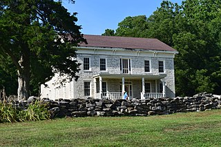
Eldred is a village in Greene County, Illinois, United States. The population was 201 at the 2010 census.

<span class="mw-page-title-main">Apple River, Illinois</span> Village in Illinois, United States

Apple River is a village in Jo Daviess County, Illinois, United States. The population was 366 at the 2010 census, down from 379 in 2000.

<span class="mw-page-title-main">East Dubuque, Illinois</span> City in Illinois, United States

East Dubuque is a city in Jo Daviess County, Illinois, United States. The population was 1,505 at the 2020 census, down from 1,704 in 2010. East Dubuque is located alongside the Mississippi River. Across the river is the city of Dubuque, Iowa. The city limits extend along the river to the Illinois – Wisconsin border.

<span class="mw-page-title-main">Elizabeth, Illinois</span> Village in Illinois, United States

Elizabeth is a village in Jo Daviess County, Illinois, United States. The population was 761 at the 2010 census.

<span class="mw-page-title-main">Menominee, Illinois</span> Village in Illinois, United States

Menominee is a village in Jo Daviess County, Illinois, United States. The population was 248 at the 2010 census, up from 237 in 2000. The village is located on the Little Menominee River near East Dubuque and Galena.

<span class="mw-page-title-main">Nora, Illinois</span> Village in Illinois, United States

Nora is a village in Jo Daviess County, Illinois, United States. In 2020, the population was 107, down from 121 at the 2010 census, which was up from 118 in 2000.

<span class="mw-page-title-main">Scales Mound, Illinois</span> Village in Illinois, United States

Scales Mound is a village in Jo Daviess County, Illinois, United States. The population was 376 at the 2010 census, down from 401 in 2000.

<span class="mw-page-title-main">Stockton, Illinois</span> Village in Illinois, United States

Stockton is a village in Jo Daviess County, Illinois, United States. The population was 1,862 at the 2010 census, down from 1,926 at the 2000 census.

<span class="mw-page-title-main">Warren, Illinois</span> Village in Illinois, United States

Warren is a village in Jo Daviess County, Illinois, United States. The population was 1,323 at the 2020 census, down from 1,428 at the 2010 census.

<span class="mw-page-title-main">Medora, Illinois</span> Village in Illinois, United States

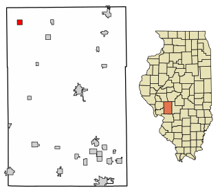
Medora is a village in Macoupin County, Illinois, United States. The population was 379 at the 2020 census, down from 419 in 2010.

<span class="mw-page-title-main">Scottville, Illinois</span> Village in Illinois, United States

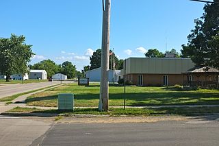
Scottville is a village in Macoupin County, Illinois, United States. The population was 93 at the 2020 census.

<span class="mw-page-title-main">South Roxana, Illinois</span> Village in Illinois, United States

South Roxana, incorporated in March 1967, is a village in Madison County, Illinois, United States. The population was 1,891 at the 2020 census.

<span class="mw-page-title-main">Panola, Illinois</span> Village in Illinois, United States

Panola is a village in Woodford County, Illinois, United States. The population was 45 at the 2010 census. It is part of the Peoria, Illinois Metropolitan Statistical Area.

<span class="mw-page-title-main">Wapello, Iowa</span> City in Iowa, United States

Wapello is a city in and the county seat of Louisa County, Iowa, United States. The population was 2,084 at the time of the 2020 census.

References

  1. 1 2 Village of Hanover - official website
  2. "2020 U.S. Gazetteer Files". United States Census Bureau. Retrieved March 15, 2022.
  3. "USGS detail on Newtown" . Retrieved 2007-10-21.
  4. "ILLINOIS NATURE PRESERVES COMMISSION TWO HUNDRED TWENTY-NINTH MEETING" (PDF). Illinois Department of Natural Resources. Retrieved 22 January 2019.
  5. "US Gazetteer files: 2010, 2000, and 1990". United States Census Bureau. 2011-02-12. Retrieved 2011-04-23.
  6. "2010 Census U.S. Gazetteer Files for Places – Illinois". United States Census. Archived from the original on 2013-01-12. Retrieved 2012-10-13.
  7. "Census of Population and Housing". Census.gov. Retrieved June 4, 2015.
  8. "U.S. Census website". United States Census Bureau . Retrieved 2008-01-31.
  9. "River Ridge Info." River Ridge Community Unit School District 210. Retrieved on July 15, 2018.
  10. 'Charles W. Woodford-obituary,' Dubuque Telegraph Herald,, February 25, 2009
  11. "Obituary: Former State Representative Carol Cleven, 86". Chelmsford, MA Patch. 2015-03-16. Retrieved 2021-11-03.