Hanson, Kentucky

Last updated
Hanson, Kentucky
Hanson Historic District.jpg
Main Street downtown
Hopkins County Kentucky Incorporated and Unincorporated areas Hanson Highlighted 2134390.svg
Location of Hanson in Hopkins County, Kentucky.
Coordinates: 37°25′4″N87°28′50″W / 37.41778°N 87.48056°W / 37.41778; -87.48056 Coordinates: 37°25′4″N87°28′50″W / 37.41778°N 87.48056°W / 37.41778; -87.48056
Country United States
State Kentucky
County Hopkins
Founded1869
Incorporated1873
Named for a local railroad employee
Government
  MayorJimmy Epley
Area
[1]
  Total2.37 sq mi (6.13 km2)
  Land2.35 sq mi (6.10 km2)
  Water0.01 sq mi (0.03 km2)
Elevation
436 ft (133 m)
Population
 (2020)
  Total758
  Density321.87/sq mi (124.27/km2)
Time zone UTC-6 (CST)
  Summer (DST) UTC-5 (CDT)
ZIP Code
42413
Area code(s) 270 & 364
FIPS code 21-34390
GNIS feature ID0493695
Website www.cityofhanson.com

Hanson is a home rule-class city in Hopkins County, Kentucky, in the United States. The population was 742 at the 2010 census, [2] up from 625 at the 2000 census.

Contents

The Hanson Historic District is located in the city. The companies that supply power to Hanson residents are Kentucky Utilities and Kenergy.

History

The town was founded in 1869 on a 50-acre (20 ha) grant from two local landowners, judge Robert Eastwood and pastor Roland Gooch, in order to function as a stop on the Evansville, Henderson, and Nashville Railroad. The city was laid out by (and named for) a railway's engineer and surveyor named Henry B. Hanson. [3] The community received its post office on December 7, 1869, [4] and was incorporated by the state assembly on March 31, 1873. [5]

The Evansville, Henderson, & Nashville was purchased by the St. Louis and Southeastern in 1872, which (following a reorganization) was purchased in turn by the L&N in 1879.

The city was essentially destroyed by a fire in 1889, [3] and the present historic district dates from the rebuilding that followed. [6] Today, the former L&N network makes up part of CSX Transportation, which operates a siding track in Hanson.

Geography

Hanson is located in northern Hopkins County at 37°25′4″N87°28′50″W / 37.41778°N 87.48056°W / 37.41778; -87.48056 (37.417794, -87.480647). [7] U.S. Route 41 (Hanson Road) passes through the center of town, and Interstate 69 passes through the eastern part, with access from Exit 120. Madisonville, the county seat, is 6 miles (10 km) to the south, and Henderson is 32 miles (51 km) to the north, via either highway.

According to the United States Census Bureau, Hanson has a total area of 2.6 square miles (6.8 km2), of which 0.01 square miles (0.03 km2), or 0.50%, are water. [2]

Demographics

Historical population
CensusPop.
1880 217
1890 37673.3%
1900 54946.0%
1910 509−7.3%
1920 216−57.6%
1930 41190.3%
1940 364−11.4%
1950 3938.0%
1960 376−4.3%
1970 3780.5%
1980 48528.3%
1990 450−7.2%
2000 62538.9%
2010 74218.7%
2020 7582.2%
U.S. Decennial Census [8]

As of the census [9] of 2000, there were 625 people, 241 households, and 187 families residing in the city. The population density was 265.1 people per square mile (102.3/km2). There were 265 housing units at an average density of 112.4 per square mile (43.4/km2). The racial makeup of the city was 97.76% White, 0.48% Black or African American, 0.96% Asian, and 0.80% from two or more races. Hispanic or Latino of any race were 0.64% of the population.

There were 241 households, out of which 38.6% had children under the age of 18 living with them, 66.8% were married couples living together, 7.9% had a female householder with no husband present, and 22.0% were non-families. 19.5% of all households were made up of individuals, and 10.4% had someone living alone who was 65 years of age or older. The average household size was 2.59 and the average family size was 2.90.

In the city, the population was spread out, with 26.2% under the age of 18, 6.4% from 18 to 24, 29.3% from 25 to 44, 26.6% from 45 to 64, and 11.5% who were 65 years of age or older. The median age was 39 years. For every 100 females, there were 92.9 males. For every 100 females age 18 and over, there were 89.7 males.

The median income for a household in the city was $31,250, and the median income for a family was $36,406. Males had a median income of $32,054 versus $21,731 for females. The per capita income for the city was $14,932. About 6.7% of families and 12.5% of the population were below the poverty line, including 11.3% of those under age 18 and 16.1% of those age 65 or over.

Related Research Articles

Webster County, Kentucky County in Kentucky, United States

Webster County is a county located in the U.S. state of Kentucky. As of the 2010 census, the population was 13,621. Its county seat is Dixon. It is the southernmost county in the Evansville, IN–KY Metropolitan Statistical Area. The county was formed in 1860 from parts of Henderson, Hopkins, and Union Counties and named for American statesman Daniel Webster (1782-1852). It was mainly pro-Confederate during the American Civil War and was the site of several skirmishes and some guerrilla warfare. Since 2018 it has been a moist county, with Providence and Sebree voting to allow alcohol sales.

Hopkins County, Kentucky County in Kentucky, United States

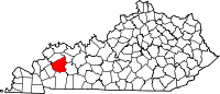
Hopkins County is a county located in the western part of the U.S. state of Kentucky. As of the 2010 census, the population was 46,920. Its county seat is Madisonville. Hopkins County was created 9 December 1806 from Henderson County. It was named for General Samuel Hopkins, an officer in both the American Revolutionary War and War of 1812, and later a Kentucky legislator and U.S. Congressman.

Henderson County, Kentucky County in Kentucky, United States

Henderson County is a county in the U.S. state of Kentucky. The county is located in western Kentucky on the Ohio River across from Evansville, Indiana. As of the 2010 census, the population was 46,250. The county seat is Henderson.

Hopedale, Illinois Village in Illinois, United States

Hopedale is a village in Tazewell County, Illinois, United States. The population was 865 at the 2010 census. It is part of the Peoria, Illinois Metropolitan Statistical Area. The town is also home to a small number of restaurants, general stores, parks, and the Hopedale Medical Complex.

Rockport, Indiana City in Indiana, United States

Rockport is a city in Ohio Township, Spencer County, Indiana, along the Ohio River. The population was 2,270 at the 2010 census. Once the largest community in Spencer County, the city has recently been surpassed by the town of Santa Claus. The city is the county seat of Spencer County. At 37°53'1" north, Rockport is also the southernmost city in the state, located slightly south of Evansville, Cannelton, or Mount Vernon.

Crestview, Kentucky City in Kentucky, United States

Crestview is a home rule-class city in Campbell County, Kentucky, in the United States. The population was 475 at the 2010 census.

Crofton, Kentucky City in Kentucky, United States

Crofton is a home rule-class city in Christian County, Kentucky, in the United States. The population was 749 at the 2010 census.

Corydon, Kentucky City in Kentucky, United States

Corydon is a home rule-class city and former coal town in Henderson County, Kentucky, United States. The population was 720 at the 2010 census.

Earlington, Kentucky City in Kentucky, United States

Earlington is a home rule-class city in Hopkins County, Kentucky, in the United States. As of the 2010 census, the city had a population of 1,413, down from 1,649 at the 2000 census.

Madisonville, Kentucky City in Kentucky, United States

Madisonville is a home rule-class city in and the county seat of Hopkins County, Kentucky, United States, located along Interstate 69 in the state's Western Coal Fields region. The population was 19,591 at the 2010 census. Madisonville is a commercial center of the region and is home to Madisonville Community College.

Mortons Gap, Kentucky City in Kentucky, United States

Mortons Gap is a home rule-class city in Hopkins County, Kentucky, in the United States. The population was 863 at the 2010 census, down from 952 at the 2000 census.

Nebo, Kentucky City in Kentucky, United States

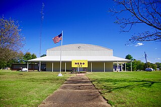
Nebo is a home rule-class city in Hopkins County, Kentucky, in the United States. The population was 236 as of the 2010 census.

Nortonville, Kentucky City in Kentucky, United States

Nortonville is a home rule-class city in Hopkins County, Kentucky, in the United States. The population was 1,204 as of the 2010 census.

St. Charles, Kentucky City in Kentucky, United States

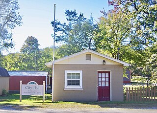
St. Charles is a home rule-class city in Hopkins County, Kentucky, United States. The population was 277 at the 2010 U.S. Census.

White Plains, Kentucky City in Kentucky, United States

White Plains is a home rule-class city in Hopkins County, Kentucky, United States. The population was 884 at the 2010 census, up from 800 at the 2000 census.

Glenview Manor, Kentucky City in Kentucky, United States

Glenview Manor is a home rule-class city in Jefferson County, Kentucky, United States. The population was 191 at the 2010 census.

Island, Kentucky City in Kentucky, United States

Island is a home rule-class city in McLean County, Kentucky, in the United States. The population was 458 at the 2010 census. It is included in the Owensboro metropolitan area.

Milroy, Minnesota City in Minnesota, United States

Milroy is a city in Redwood County, Minnesota, United States. The population was 252 at the 2010 census. It is named after Robert H. Milroy, a Union Army general in the American Civil War.

Johnson, Oklahoma Town in Oklahoma, United States

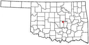
Johnson is a town in north-central Pottawatomie County, Oklahoma, United States. The population was 247 at the 2010 census, a 10.8 percent increase from the figure of 223 in 2000.

Forestville, Wisconsin Village in Wisconsin, United States

Forestville is a village in Door County, Wisconsin, United States, along the Ahnapee River. The population was 430 at the 2010 census. The village is located within the Town of Forestville. The village uses the 54213 ZIP code. The Ahnapee State Trail passes through the village on the southwest.

References

  1. "2020 U.S. Gazetteer Files". United States Census Bureau. Retrieved March 18, 2022.
  2. 1 2 "Geographic Identifiers: 2010 Demographic Profile Data (G001): Hanson city, Kentucky". American Factfinder. U.S. Census Bureau. Retrieved July 6, 2017.[ dead link ]
  3. 1 2 "Hanson". Historical Marker Database. Retrieved 24 September 2015.
  4. Rennick, Robert M. (1987). Kentucky Place Names. University Press of Kentucky. pp. 129–130. Retrieved 28 April 2013.
  5. Commonwealth of Kentucky. Office of the Secretary of State. Land Office. "Hanson, Kentucky". Accessed 29 July 2013.
  6. City of Hanson. "Hanson Historic District Archived 2013-08-31 at the Wayback Machine ". Accessed 29 July 2013.
  7. "US Gazetteer files: 2010, 2000, and 1990". United States Census Bureau. 2011-02-12. Retrieved 2011-04-23.
  8. "Census of Population and Housing". Census.gov. Retrieved June 4, 2015.
  9. "U.S. Census website". United States Census Bureau . Retrieved 2008-01-31.