Haraguchi Rice Mill

Last updated
Haraguchi Rice Mill
Haraguchi Rice Mill, Hanalei River, Hanalei (Kauai County, Hawaii).jpg
USA Hawaii location map.svg
Red pog.svg
Location4650 Ohiki Road, Hanalei, Hawaii
Coordinates 22°12′35″N159°28′36″W / 22.20972°N 159.47667°W / 22.20972; -159.47667
Arealess than one acre
Built1930
NRHP reference No. 83000252 [1]
HRHP No.50-30-03-09385 [2]
Significant dates
Added to NRHPAugust 25, 1983
Designated HRHPJune 27, 1983

The Haraguchi Rice Mill, on Ohiki Road in Hanalei, Hawaii, on Kauai, is one of five former rice mills in Hanalei Valley. It was built in 1930 and was a corrugated iron structure on a concrete pad. It is listed on the National Register of Historic Places. [1] [3] It was listed on the National Register in 1983; the listing included one contributing structure and four contributing objects. [1] The listing was shortly after 1982 Hurricane Iwa had collapsed the rice mill structure. Heavy machinery including an engine were not significantly harmed, however, and it was then thought that the structure could be restored. [3]

Contents

Origin

The majority of the extraordinary buildings in the community Hanalei of Hawaii were built during the rice era started in the 1860s.  This was a farming area where there were mostly flat lands and agriculture was the main industry, there were crops like tobacco, coffee, and sugarcane.  In 1884 there was an increase in Chinese farmers, who started leasing lands which made rice become the main economic crop eventually. The Haraguchi Rice Farm was founded in Hanalei by Ine and Tomijiro Haraguchi.  Along with being the largest rice farmers, they also took part in fishing the water of Hanalei Bay.  The Haraguchi Rice Mill was reconstructed in 1930.  It was a one-room shack that had sections for milling, and engine operation and an area for the storage of processed and unprocessed rice. It had an apex-style metal roof. The Haraguchi Rice Mill was shut down in 1960, which made it the last mill out of the five rice mills to be closed in Hawaii. This was due to competition from the United States and damage done by the rice birds, which eventually made the Haraguchi Rice Mill unprofitable.

Rice production in Hanalei

Approximately 4 months after planting rice is ready to be harvested.  The rice farmers in Hanalei did not have much time to rest, they planted rice all year round and when the work got intensive farmers would pool together and help each other.  The rice seeds were planted into seedbeds and incorporated with organic manure 3 inches high, within several days the seeds germinate into seedlings.  The most prominent rice pest in Hanalei was the Chinese Sparrow, also called the Nutmeg Manikins.  They would drank the milk from the rice as it matured and ate the kernels as well.  These birds had to be scared away by cans filled with stone which made noise as they pitched on the strings connecting them.  The Hanalei River running through the Hanalei Valley made agricultural production more feasible due to the readily available water supply. This river was available to almost everyone on this Pacific island because of its heavy flow of fresh water.

Hawaii rice economy

The Haraguchi Rice Mill played a huge role in the agricultural history of Hanalei. Rice was first cultivated on the island by the Chinese first and taken over by the Japanese years after. In 1879 farmers were getting approximately $15 to $18 per bag.  The Japanese rice was planted mainly for home consumption, while the Chinese rice was exported or shipped elsewhere.   

Natural disasters

The Haraguchi Rice Mill was rebuilt in 1930 after it was destroyed by a fire in March of that year.  Following this disaster, in 1959 Hurricane Dot damaged the roof and air vent of the milling machine at the Haraguchi Rice Mill.  Then in 1982 the mill was massively destroyed by Hurricane Iwa in the month of November. The whole milling house collapsed onto the milling machine which was safe and ready to mill again.  In 1992 Hurricane Iniki passed over this disaster prone farm site once again.  

Legacy

The Haraguchi Rice Mill was the fifth rice mill in Hanalei of Hawaii. It impacted families and communities in and around the island. Even though it has gone through many disasters during its time of maximum production, Haraguchi Rice Mill contributed to the islands economy where it provided jobs, increased foreign exchange earnings and established rice as a staple food for the Chinese and Japanese farmers.  Today the farm has no rice on it but instead it has taro and it is a non-profit business that is facilitates personal development for schools and offer back to nature visits.  This farm now makes traditional dishes freshly from taro, which is harvested straight off the farm. It still embraces its originality and traditional values in 2019.

[4] [5] [6] Currently the Haraguchi Farm is still own today by the Haraguchi family sixth generation, this farm is going over 100 year old.  On the farm presently they have taro production; also this farm in Hanalei, Hawaii is utilized as a back to nature tour, where it's a non-profit entity.  The Haraguchi Farm is now used to serve the Hawaii Island as a recreational center for tours such as schools and other tourists, in the same breathe Hawaiian students are train how to grow and harvest taro. Taro cultivation also supports small businesses in and around the community of Hanalei. From taro the by-products and other ancient dishes are made, which as a lucrative market within the community.   Today the Haraguchi Family Farm is still in progress.

Related Research Articles

<span class="mw-page-title-main">Kauai</span> Northernmost populated island of the Hawaiian archipelago

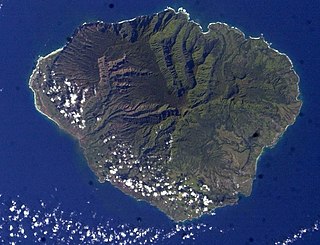
Kauaʻi, anglicized as Kauai, is one of the main Hawaiian Islands.

<span class="mw-page-title-main">Hanalei, Hawaii</span> Census-designated place in Hawaii, United States

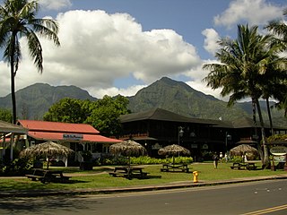
Hanalei is a census-designated place (CDP) in Kauaʻi County, Hawaii, United States. The population was estimated at 299 as of 2019. Hanalei means "lei making" in Hawaiian. Alternatively, the name Hanalei also means "crescent bay" and may be indicative of the shape of Hanalei Bay. Hanalei can also be translated as lei valley, referring to the rainbows that color the valley and encircle Hanalei like a wreath.

<span class="mw-page-title-main">Hurricane Iniki</span> Category 4 Pacific hurricane in 1992

Hurricane Iniki was a hurricane that struck the island of Kauaʻi on September 11, 1992. It was the most powerful hurricane to strike Hawaiʻi in recorded history, and the only hurricane to directly affect the state during the 1992 Pacific hurricane season. Forming on September 5, 1992, during the strong 1990–1995 El Niño, Iniki was one of eleven Central Pacific tropical cyclones during that season. It attained tropical storm status on September 8 and intensified into a hurricane the next day. After abruptly turning north, Iniki struck Kauaʻi at peak intensity; it had winds of 145 mph and reached Category 4 status on the Saffir–Simpson hurricane scale.

<span class="mw-page-title-main">Hurricane Iwa</span> Category 1 Pacific hurricane in 1982

Hurricane Iwa, taken from the Hawaiian language name for the frigatebird, was at the time the costliest hurricane to affect the state of Hawaiʻi. Iwa was the twenty-third tropical storm and the twelfth and final hurricane of the 1982 Pacific hurricane season. It developed from an active trough of low pressure near the equator on November 19. The storm moved erratically northward until becoming a hurricane on November 23 when it began accelerating to the northeast in response to strong upper-level flow from the north. Iwa passed within 25 miles of the island of Kauaʻi with peak winds of 90 mph (140 km/h) on November 23, and the next day it became extratropical to the northeast of the state.

<span class="mw-page-title-main">Taro</span> Species of plant

Taro is a root vegetable. It is the most widely cultivated species of several plants in the family Araceae that are used as vegetables for their corms, leaves, stems and petioles. Taro corms are a food staple in African, Oceanic, East Asian, Southeast Asian and South Asian cultures. Taro is believed to be one of the earliest cultivated plants.

<span class="mw-page-title-main">Russian Fort Elizabeth</span> Historic Place in Kauai County, Hawaii

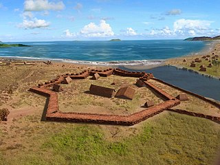
Pā'ula'ula State Historical Park is a National Historic Landmark and is administered as the Pā'ula'ula State Historical Park just southeast of present-day Waimea on the island of Kauaʻi in Hawaiʻi. It is located at the site of the former Fort Elizavety, the last remaining Russian fort on the Hawaiian islands, built in the early 19th century by the Russian-American Company as the result of an alliance with High Chief Kaumualiʻi. The star fort was employed by the Kingdom of Hawaii in the 19th century under the name Fort Hipo.

<span class="mw-page-title-main">Hanalei River</span> River in Hawaii, United States

The Hanalei River on the island of Kauaʻi in Hawaii flows north from the eastern slopes of Mount Waiʻaleʻale for 26.5 km (16.5 mi) until it reaches the Pacific Ocean at Hanalei Bay as an estuary. With a long-term mean discharge of 216 cubic feet per second, in terms of water flow it is the second-largest river in the state; although its watershed of 57 square kilometres (22 sq mi) is only sixth-largest on Kauaʻi, it encompasses areas of the highest recorded rainfall on the planet and plunges precipitously from its headwaters at 3,500 feet (1,100 m) above sea level.

<span class="mw-page-title-main">Hurricane Dot (1959)</span> Category 4 Pacific hurricane in 1959

Hurricane Dot was a powerful hurricane which affected Hawaii in August 1959, making it, at the time, the costliest tropical cyclone in Hawaiian history. Dot was first identified as a strong tropical storm southeast of Hawaiʻi on August 1. The storm was potentially a continuation of a previously unnamed tropical cyclone that was monitored west of the Baja California Peninsula from July 24–27, but was never confirmed due to a lack of ship reports. Dot was quick to intensify, reaching hurricane intensity six hours after naming. By August 3, Dot reached its peak intensity, with maximum sustained winds reaching 150 mph (240 km/h). Intensity leveled off afterwards as Dot tracked westward before making a curve towards the northwest on August 5, after which the hurricane weakened at a faster clip. Dot made landfall the next day on Kauai as a minimal hurricane before dissipating west of the Hawaiian Islands on August 8.

<span class="mw-page-title-main">Hanalei Bay</span> Bay on Kauaʻi, Hawaii

Hanalei Bay is the largest bay on the north shore of Kauaʻi island in Hawaii. The town of Hanalei is at the midpoint of the bay.

<span class="mw-page-title-main">Hawaii Route 560</span> State highway in Hawaii, United States

Route 560, or Kaua'i Belt Road-North Shore section, is a ten-mile (16 km) scenic road on the northern shore of the island of Kauaʻi in Hawaii. The entire belt road is signed as the Kuhio Highway. Hawaii Route 56 was once signed on this route before it was downgraded to become Hawaii Route 560 in the late 1960s. The Kuhio Highway is named after Jonah Kūhiō Kalaniana'ole, the second non-voting Congressional Delegate from territorial Hawaii.

Hurricane Nina was the final tropical storm and hurricane of the 1957 Pacific hurricane season and the last storm to form during the active Central Pacific hurricane season this year. This storm was named "Nina" because during this time, hurricanes in this basin were given names from the typhoon naming lists. This storm was the last to form during a series of typhoons and hurricanes to form in the Pacific in November.

<span class="mw-page-title-main">Hanalei National Wildlife Refuge</span> Wetlands in Kauaʻi, Hawaiʻi, U.S.

The Hanalei National Wildlife Refuge is a National Wildlife Refuge on the island of Kauaʻi in Hawaiʻi. It is located within the Hanalei River Valley along the island's northern shore. The Refuge was established on 30 November 1972 for the conservation of endangered plants and animals, especially the Hawaiian stilt, Hawaiian coot, Hawaiian gallinule and Hawaiian duck.

<span class="mw-page-title-main">Hanalei Pier</span> United States historic place

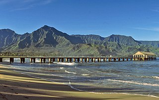
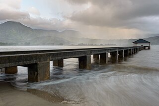
Hanalei Pier is a pier built into Hanalei Bay on the northern shore of the island of Kauaʻi in the state of Hawaii.

<span class="mw-page-title-main">Waiʻoli Mission District</span> Historic district in Hawaii, United States

The Waiʻoli Mission District at Hanalei Bay, on Route 560 along the north shore of the island of Kauaʻi, is the site of a historic mission. The first permanent missionaries to the area arrived in 1834, and the district was added to the National Register of Historic Places in 1973.

<span class="mw-page-title-main">Heritage railways in Kauai</span> United States historic place

There are two heritage railways in Kauai, the birthplace of Hawaiian railroading. It was added to the National Register of Historic Places on January 19, 1979.

<span class="mw-page-title-main">Grove Farm (Lihue, Hawaii)</span> Historic house in Hawaii, United States

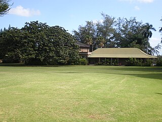
Grove Farm is a historic agricultural site on Kauai in the Hawaiian Islands.

<span class="mw-page-title-main">Albert Spencer Wilcox Building</span> United States historic place

The Albert Spencer Wilcox Building is a historic building in Līhuʻe, Kauaʻi, Hawaii. Originally a library when it opened in 1924, it was later converted into the Kauaʻi Museum. It has exhibits on the history of the island of Kauaʻi. It was added to both the Hawaiʻi Register of Historic Places and the National Register of Historic Places in 1979.

<span class="mw-page-title-main">Civilian Conservation Corps Camp in Kokeʻe State Park</span> United States historic place

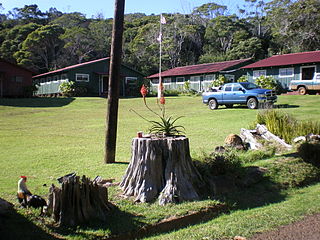
Civilian Conservation Corps Camp in Kokeʻe State Park is located at Hawaii Route 550, in Waimea, on the island of Kauai, in the U.S. state of Hawaii. It was built in 1935 with lumber that was put into the saltwater and floated to the shore at Port Allen, the seawater adding a natural termite protection to the lumber. The camp was in continual use for forest management, until Hurricane Iwa devastated it in 1982. In the 1990s it was restored through the efforts of the non-profit Hui O Laka environmental group, and is currently open to the public. It was added to the Hawaiʻi Register of Historic Places and the National Register of Historic Places on December 20, 1996.

<span class="mw-page-title-main">2018 Hawaii floods</span> Record-breaking rainfall on the Hawaiian Islands of Kauaʻi and Oahu

In April 2018, a series of thunderstorms produced record-breaking rainfall on the Hawaiian Islands of Kauaʻi and Oahu. An upper-level low moved across the area on April 13, generating a mesoscale convective system that moved over eastern Oahu, producing localized heavy rainfall that reached 5.55 in (141 mm). The heaviest rainfall occurred on northern Kauaʻi. There, a rain gauge owned by the Waipā Foundation, just west of Hanalei, recorded 49.69 in (1,262 mm) of rainfall in the 24 hours between 12:45 p.m. on April 14 and 15. This was the greatest 24-hour rainfall total on record in the United States, surpassing the previous record of 43 in (1,100 mm) in Alvin, Texas on July 25–26, 1979, set during Tropical Storm Claudette. Through the event, the same gauge recorded a total of 54.37 in (1,381 mm) of rain.

References

  1. 1 2 3 "National Register Information System". National Register of Historic Places . National Park Service. July 9, 2010.
  2. "Historic Register Counts". Hawai'i State Historic Preservation Division. State of Hawaii. February 1, 2022. Retrieved March 8, 2022.
  3. 1 2 Karol M. Haraguchi (February 8, 1983). "National Register of Historic Places Inventory/Nomination: Haraguchi Rice Mill". National Park Service. and accompanying three photos from 1983
  4. "A Comprehensive Guide To The Hawaii Islands History, Culture, Native Species, Science" . Retrieved April 28, 2019.
  5. Harrington, Daniel (July 15, 1983). "National Register of Historic Places Inventory-Nomination Form" . Retrieved April 28, 2019.
  6. Riznik, Barnes (Summer 1989). "Hanalei Bridge: A Catalyst for Rural Preservation" (PDF). The Public Historian. 11 (3): 45–67. doi:10.2307/3378612. JSTOR   3378612.