
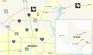
Harris County is in Southeast Texas next to Galveston Bay. As of the 2010 census, the population was 4,092,459, making it the most populous county in Texas and the third most populous county in the United States. Its county seat is Houston, the largest city in Texas and fourth largest city in the United States. The county was founded in 1836 and organized in 1837. It is named for John Richardson Harris, who founded the town of Harrisburg on Buffalo Bayou in 1826. According to a July 2018 census estimate, Harris County's population had grown to 4,698,619, comprising over 16% of Texas's population. Harris County is included in the nine-county Houston–The Woodlands–Sugar Land metropolitan statistical area, which is the fifth-most populous metropolitan area in the United States.

Aldine is a census-designated place (CDP) in unincorporated central Harris County, Texas, United States, located within the extraterritorial jurisdiction of Houston. The population was 15,869 at the 2010 census. The community is located on the Hardy Toll Road, Union Pacific Railroad, and Farm to Market Road 525.

Humble is a city located in Harris County, Texas, United States, within the Houston metropolitan area. Famously, Humble became an oil boomtown in the early 20th century when oil was first discovered there in 1904. By 1905, the Humble oilfield was the largest producing oilfield in Texas. Humble was home of Humble Oil, a predecessor of Exxon.

Spring is a census-designated place (CDP) within the extraterritorial jurisdiction of Houston in Harris County, Texas, United States, part of the Houston–The Woodlands–Sugar Land metropolitan area. The population was 54,298 at the 2010 census. While the name "Spring" is popularly applied to a large area of northern Harris County and a smaller area of southern Montgomery County, the original town of Spring, now known as Old Town Spring, is located at the intersection of Spring-Cypress and Hardy roads and encompasses a relatively small area of perhaps 1 square kilometre (0.39 sq mi).

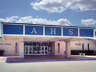
Chester W. Nimitz Senior High School is a public secondary school made up of two campuses located in unincorporated Harris County, Texas, United States. The campuses have Houston addresses. The school is located directly across the street from Lone Star College–North Harris and west of Bush Intercontinental Airport The school serves portions of Houston, the Aldine Independent School District portion of Humble, and unincorporated areas of Harris County. Nimitz is one of five comprehensive high schools in Aldine ISD. The main campus serves grades 10 through 12, while Nimitz Ninth Grade Center serves grade 9.
The Aldine Independent School District is a public school district based in unincorporated Harris County, Texas, United States. It serves portions of Houston and unincorporated Harris County. Aldine ISD serves the communities of Aldine, most of Greenspoint, most of East Aldine, and portions of Airline, Acres Homes, Kinwood, Bordersville, and Inwood Forest. The district is part of the taxation base for the Lone Star College System. As of 2020, Dr. LaTonya Goffney serves as superintendent of schools.
Lone Star College (LSC) is a public community college system serving the northern portions of the Greater Houston, Texas, area. In 2017 it enrolled about 95,000 students. The headquarters of the Lone Star College System are located in The Woodlands and in unincorporated Montgomery County, Texas.

Acres Homes is a neighborhood located in northwest Houston, Texas. The 9-square-mile (23 km2) mile area is loosely bounded by the city limits and West Gulf Bank Road to the north; Pinemont Drive to the south; North Shepherd Drive to the east; and Alabonson Drive to the west. Historically, it has been predominantly African American. Unincorporated for decades, it was annexed to Houston in 1967.

Greater Greenspoint, uncommonly known as the North Houston District, collectively known by the locals as Guns Point, is a 7-square-mile (18 km2) business district and a suburban neighborhood in northern Harris County, Texas, United States, located mostly within the city limits of Houston. Centered around the junction of Interstate 45 and Texas State Highway Beltway 8 near George Bush Intercontinental Airport, the area is a classic example of a planned edge city. The initial 2,000-acre (8.1 km2) retail and office development centered around Greenspoint Mall was a project of the Friendswood Development Company during the 1970s and early 1980s.

Addicks is an area of Houston that was formerly its own community.
Farm to Market Road 1960 is a farm-to-market road in the U.S. state of Texas, maintained by the Texas Department of Transportation. Its western terminus is at an intersection with U.S. Highway 290 (US 290) and State Highway 6 (SH 6) in northwestern Harris County. It travels generally to the east, ending at SH 321 in Dayton in western Liberty County. FM 1960 has long been an artery in Greater Houston, though it has been shortened and re-routed over the years. Once consisting of most of the current SH 6 in West Houston as well as its current northern route, it still traverses 26 ZIP codes north of the Houston city limits.

Kendleton Independent School District was a public school district based in Powell Point, unincorporated Fort Bend County, Texas, United States, north of the city of Kendleton. The district served Kendleton and Powell Point.
Westfield is an unincorporated community in Harris County, Texas, United States located along Interstate 45 and the Union Pacific Railroad nineteen miles (30 km) north of Downtown Houston.

Bordersville is a predominantly African American community on Farm to Market Road 1960 in northeast Harris County, Texas, United States. The community, located less than one half-mile from George Bush Intercontinental Airport, has about 80% of its territory in the City of Houston and the rest in an unincorporated area.
Greater Katy Area is the term often used to refer to a suburban region on the west side of the Greater Houston metropolitan area roughly corresponding to the boundaries of the Katy Independent School District. Many people and businesses in this area have a Katy address, but not part of the city of Katy. This area includes the suburbs that surround the Katy city limits west to Pederson road, roughly east to State Highway 6, north to FM 529 and south to FM 1093/ Westpark Tollway Parkway. While these boundaries are not exact, it gives a rough outline of what most people consider Greater Katy. Most of Greater Katy is to the east of the city of Katy toward Houston and includes surrounding suburban areas and unincorporated areas that are not in the Houston city limits. The region includes parts of Harris County, Fort Bend County, and Waller County much as the City of Katy does. Greater Katy is one of the fastest growing portions of the Houston metropolitan area and the state of Texas as a whole.
Aldine Senior High School is a public high school located in the Greenspoint district of northern Houston, Texas, United States. It is part of the Aldine Independent School District. The senior high school campus serves grades 10 through 12. The separate Aldine Ninth Grade School hosts students in grade 9.

East Aldine is a state management district in Harris County, Texas, United States, mostly in unincorporated areas with some territory in the City of Houston. The East Aldine Improvement District, also known as the Aldine Management District, governs the area. Portions of the district coincide with the boundaries of the Aldine census-designated place. One park owned by the City of Houston, Keith-Wiess Park, is within the district limits.
The Airline Improvement District is a management district in unincorporated Harris County, Texas in Greater Houston and located entirely within the postal zip code of 77037.

Aldine Ninth Grade School is a public secondary school located in the Greenspoint district of northern Houston, Texas, United States. It is part of the Aldine Independent School District. As its name implies, the campus serves ninth grade. The separate Aldine High School serves students in grades 10–12. Many of the students take additional courses at the Senior High School, such as Choir or Band.
Harris County Housing Authority (HCHA) is the low-income housing and public housing authority of Harris County, Texas in Greater Houston. Its headquarters are in southern Houston. It mainly serves areas outside of Houston, as the Houston Housing Authority serves that city.
