Hartville, Wyoming

Last updated

Hartville, Wyoming
Hartville, WY.jpg
Platte County Wyoming Incorporated and Unincorporated areas Hartville Highlighted 5635625.svg
Location of Hartville in Platte County, Wyoming.
Usa edcp location map.svg
Red pog.svg
Hartville, Wyoming
Location in the United States
Coordinates: 42°19′36″N104°43′40″W / 42.32667°N 104.72778°W / 42.32667; -104.72778
Country United States
State Wyoming
County Platte
Area
[1]
  Total0.26 sq mi (0.67 km2)
  Land0.26 sq mi (0.67 km2)
  Water0.00 sq mi (0.00 km2)
Elevation
4,682 ft (1,427 m)
Population
 (2010) [2]
  Total62
  Estimate 
(2019) [3]
60
  Density231.66/sq mi (89.39/km2)
Time zone UTC-7 (Mountain (MST))
  Summer (DST) UTC-6 (MDT)
ZIP code
82215
Area code 307
FIPS code 56-35625 [4]
GNIS feature ID1589354 [5]
Website www.hartvillewyoming.com

Hartville is a town in Platte County, Wyoming, United States. The population was 62 at the 2010 census.

Contents

History

During the Old West period, Hartville was the scene of multiple shootings. Many of the victims were cowboys and are buried at the town's Boot Hill. [6]

Geography

Hartville is located at 42°19′36″N104°43′40″W / 42.32667°N 104.72778°W / 42.32667; -104.72778 (42.326783, -104.727790). [7]

According to the United States Census Bureau, the town has a total area of 0.25 square miles (0.65 km2), all land. [8]

Demographics

Historical population
CensusPop.Note
1910 235
1920 138−41.3%
1930 18937.0%
1940 179−5.3%
1950 22927.9%
1960 177−22.7%
1970 24639.0%
1980 149−39.4%
1990 78−47.7%
2000 76−2.6%
2010 62−18.4%
2019 (est.)60 [3] −3.2%
U.S. Decennial Census

2010 census

As of the census [2] of 2010, there were 62 people, 32 households, and 16 families residing in the town. The population density was 248.0 inhabitants per square mile (95.8/km2). There were 45 housing units at an average density of 180.0 per square mile (69.5/km2). The racial makeup of the town was 100.0% White. Hispanic or Latino of any race were 6.5% of the population.

There were 32 households, of which 12.5% had children under the age of 18 living with them, 46.9% were married couples living together, 3.1% had a female householder with no husband present, and 50.0% were non-families. 40.6% of all households were made up of individuals, and 18.8% had someone living alone who was 65 years of age or older. The average household size was 1.94 and the average family size was 2.69.

The median age in the town was 56 years. 12.9% of residents were under the age of 18; 0.0% were between the ages of 18 and 24; 19.3% were from 25 to 44; 38.7% were from 45 to 64; and 29% were 65 years of age or older. The gender makeup of the town was 53.2% male and 46.8% female.

2000 census

As of the census [4] of 2000, there were 76 people, 35 households, and 22 families residing in the town. The population density was 272.2 people per square mile (104.8/km2). There were 52 housing units at an average density of 186.2 per square mile (71.7/km2). The racial makeup of the town was 89.47% White, 6.58% from other races, and 3.95% from two or more races. Hispanic or Latino of any race were 22.37% of the population.

There were 35 households, out of which 25.7% had children under the age of 18 living with them, 54.3% were married couples living together, 8.6% had a female householder with no husband present, and 37.1% were non-families. 37.1% of all households were made up of individuals, and 14.3% had someone living alone who was 65 years of age or older. The average household size was 2.17 and the average family size was 2.82.

In the town, the population was spread out, with 23.7% under the age of 18, 1.3% from 18 to 24, 22.4% from 25 to 44, 18.4% from 45 to 64, and 34.2% who were 65 years of age or older. The median age was 51 years. For every 100 females, there were 100.0 males. For every 100 females age 18 and over, there were 93.3 males.

The median income for a household in the town was $25,000, and the median income for a family was $13,750. Males had a median income of $26,667 versus $0 for females. The per capita income for the town was $12,116. There were 36.4% of families and 28.4% of the population living below the poverty line, including 35.3% of under eighteens and 20.0% of those over 64.

Education

Public education in the town of Hartville is provided by Platte County School District #2. Campuses serving the town include Guernsey-Sunrise Elementary School (grades K-6) and Guernsey-Sunrise Junior/Senior High School (grades 7-12).

Highways

Related Research Articles

<span class="mw-page-title-main">Platte County, Wyoming</span> County in Wyoming, United States

Platte County is a county located in the U.S. state of Wyoming. As of the 2020 United States Census, the population was 8,605. Its county seat is Wheatland.

<span class="mw-page-title-main">Central City, Arkansas</span> City in Arkansas, United States

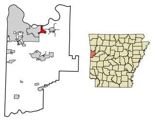
Central City is a city in Sebastian County, Arkansas, United States. It is part of the Fort Smith, Arkansas-Oklahoma Metropolitan Statistical Area. At the 2010 Census, the population of Central City was 502. According to the 2018 US Census Bureau estimates, Central City had a population of 497.

<span class="mw-page-title-main">Industry, Illinois</span> Village in Illinois, United States

Industry is a village in McDonough County, Illinois, United States. As of the 2020 census, the village population was 399, down from 478 in 2010.

<span class="mw-page-title-main">Center Point, Indiana</span> Town in Indiana, United States

Center Point is a town in Sugar Ridge Township, Clay County, Indiana, United States. The population was 242 at the 2010 census. It is part of the Terre Haute Metropolitan Statistical Area.

<span class="mw-page-title-main">Crystal, Maine</span> Town in the state of Maine, United States

Crystal is a town in Aroostook County, Maine, United States. The population was 248 at the 2020 census.

<span class="mw-page-title-main">Hersey, Maine</span> Town in the state of Maine, United States

Hersey is a town in Aroostook County, Maine, United States. The population was 73 at the 2020 census.

<span class="mw-page-title-main">Masardis, Maine</span> Town in Maine, United States

Masardis is a town in Aroostook County, Maine, United States. The population was 204 at the 2020 census.

<span class="mw-page-title-main">Merrill, Maine</span> Town in the state of Maine, United States

Merrill is a town in Aroostook County, Maine, United States. The population was 208 at the 2020 census.

<span class="mw-page-title-main">Sherman, Maine</span> Town in the state of Maine, United States

Sherman is a town in Aroostook County, Maine, United States. The population was 815 at the 2020 census.

<span class="mw-page-title-main">Westfield, Maine</span> Town in the state of Maine, United States

Westfield is a town in Aroostook County, Maine, United States. The population was 455 at the 2020 census.

<span class="mw-page-title-main">Vienna, Maine</span> Town in the state of Maine, United States

Vienna is a town in Kennebec County, Maine, United States. The population was 578 at the 2020 census.

Lakeville is a town in Penobscot County, Maine, United States. The population was 104 at the 2020 census.

Lowell is a town in Penobscot County, Maine, United States. The population was 368 at the 2020 census.

<span class="mw-page-title-main">Wawatam Township, Michigan</span> Civil township in Michigan, United States

Wawatam Township is a civil township of Emmet County in the U.S. state of Michigan. As of the 2020 census, the township population was 711.

<span class="mw-page-title-main">Hartville, Missouri</span> City in Missouri, United States

Hartville is a city in Wright County, Missouri, United States. The population was 594 at the 2020 census. It is the county seat of Wright County.

<span class="mw-page-title-main">Hartville, Ohio</span> Village in Ohio, United States

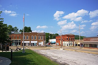
Hartville is a village in northern Stark County, Ohio, United States. The population was 3,329 at the 2020 census. It is part of the Canton–Massillon metropolitan area. Hartville lies halfway between Akron and Canton at the intersection of State Routes 43 and 619.

<span class="mw-page-title-main">Boggs Township, Clearfield County, Pennsylvania</span> Township in Pennsylvania, United States

Boggs Township is a township in Clearfield County, Pennsylvania, United States. The population was 1,666 at the 2020 census.

<span class="mw-page-title-main">Lake Monticello, Virginia</span> Census-designated place in Virginia, United States

Lake Monticello, a private gated community, is a census-designated place (CDP) in Fluvanna County, Virginia, United States. The population was 10,126 at the 2020 census. The community is centered on a lake of the same name, which is formed by a dam on a short tributary of the nearby Rivanna River. Lake Monticello is part of the Charlottesville Metropolitan Statistical Area. Lake Monticello was developed in the 1960s as a summer vacation home community but quickly evolved into a bedroom community of Charlottesville, and to a smaller extent of Richmond. It also has a sizable retirement age population.

<span class="mw-page-title-main">Guernsey, Wyoming</span> Town in Wyoming, United States

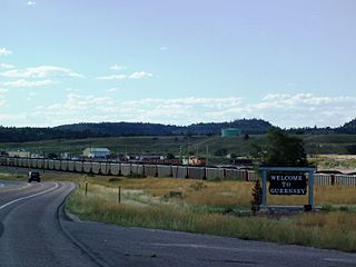
Guernsey is a town in Platte County, Wyoming, United States. The population was 1,147 at the 2010 census.

Sand Lake is an unorganized territory in Saint Louis County, Minnesota, United States, located within the unincorporated area of Britt. The population was 1,130 at the 2020 census.

References

  1. "2019 U.S. Gazetteer Files". United States Census Bureau. Retrieved August 7, 2020.
  2. 1 2 "U.S. Census website". United States Census Bureau . Retrieved December 14, 2012.
  3. 1 2 "Population and Housing Unit Estimates". United States Census Bureau. May 24, 2020. Retrieved May 27, 2020.
  4. 1 2 "U.S. Census website". United States Census Bureau . Retrieved January 31, 2008.
  5. "US Board on Geographic Names". United States Geological Survey. October 25, 2007. Retrieved January 31, 2008.
  6. "HARTVILLE, WYOMING - Profile". Archived from the original on September 1, 2012. Retrieved July 2, 2016.
  7. "US Gazetteer files: 2010, 2000, and 1990". United States Census Bureau. February 12, 2011. Retrieved April 23, 2011.
  8. "US Gazetteer files 2010". United States Census Bureau . Retrieved December 14, 2012.