
The Tacony–Palmyra Bridge is a combination steel tied-arch and double-leaf bascule bridge across the Delaware River that connects New Jersey Route 73 in Palmyra, New Jersey with Pennsylvania Route 73 in the Tacony section of Philadelphia. The bridge, designed by Polish-born architect Ralph Modjeski, has a total length of 3,659 feet (1,115 m) and spans 2,324 feet (708 m). After one and a half years of construction, it opened on August 14, 1929, replacing ferry service that had operated between Tacony and Palmyra since May 6, 1922.
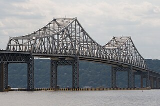
The Governor Malcolm Wilson Tappan Zee Bridge, commonly known as the Tappan Zee Bridge, was a cantilever bridge in the U.S. state of New York. It was built from 1952 to 1955 to cross the Hudson River at one of its widest points, 25 miles (40 km) north of Midtown Manhattan, from South Nyack to Tarrytown. As an integral conduit within the New York Metropolitan Area, the bridge connected South Nyack in Rockland County with Tarrytown in Westchester County in the Lower Hudson Valley.

The Sellwood Bridge is a deck arch bridge that spans the Willamette River in Portland, Oregon, in the United States. The current bridge opened in 2016 and replaced a 1925 span that had carried the same name. The original bridge was Portland's first fixed-span bridge and, being the only river crossing for miles in each direction, the busiest two-lane bridge in Oregon. The Sellwood Bridge links the Sellwood and Westmoreland neighborhoods of Portland on the east side with Oregon Route 43/Macadam Avenue on the west side. At its east end it leads to Tacoma Street. The bridge is owned and operated by Multnomah County. The original span of 1925 was a steel truss bridge, while its 2016 replacement is a deck-arch-type bridge.

The Silver Jubilee Bridge crosses the River Mersey and the Manchester Ship Canal at Runcorn Gap between Runcorn and Widnes in Halton, England. It is a through arch bridge with a main arch span of 361 yards. It was opened in 1961 as a replacement for the Widnes-Runcorn Transporter Bridge. In 1975–77 the carriageway was widened, after which the bridge was given its official name in honour of the Queen's Silver Jubilee. It carries the A533 road and a cantilevered footway. The bridge is recorded in the National Heritage List for England as a designated Grade II listed building. The bridge was closed to vehicles for refurbishment upon the opening of the new Mersey Gateway Bridge, but reopened as a toll bridge in February 2021.

The 10th Avenue Bridge crosses the Mississippi River near downtown Minneapolis, Minnesota and also in proximity to the University of Minnesota. The bridge historically was called the Cedar Avenue Bridge from days prior to the construction of the I-35W bridge when it connected to Cedar Ave. The bridge connects 10th Avenue Southeast, on the east side of the Mississippi River to 19th Avenue South, on the west side. The Seven Corners area of the Cedar-Riverside, Minneapolis neighborhood is at the south end of the bridge. The downstream end of the lower Saint Anthony Falls lock and dam extends under the bridge. The historic Southeast Steam Plant is also nearby.

The fourth Berkley–Dighton Bridge is a four-span concrete arch bridge with closed spandrel walls of cast-in-place concrete, using pile-supported abutments and piers. The bridge was made such that it appears to be constructed of stone masonry rather than concrete. The two end spans are 74 feet (23 m) and the two center spans are 92 feet (28 m) for a total bridge length of approximately 350 feet (110 m).

The Wakota Bridge is a ten-lane bridge carrying Interstate 494 over the Mississippi River between South St. Paul and Newport, Minnesota, United States. It was completed in 2010, replacing a four-lane span built in 1959. The name was given to the previous span in the early 1960s, and is derived from the two counties it connects, Washington and Dakota. Lunda Construction Company won the bid to build a new five-lane west-bound span, remove the existing bridge, and build a new five-lane east-bound span, which was completed in 2010. It is the widest bridge in Minnesota in number of lanes, along with the I-35W Saint Anthony Falls Bridge in Minneapolis.

Interstate 35W (I-35W) is an Interstate Highway in the US state of Minnesota, passing through downtown Minneapolis. It is one of two through routes for I-35 through the Twin Cities of Minneapolis and Saint Paul, the other being I-35E through downtown Saint Paul.
The Lafayette Bridge is a bridge carrying U.S. Route 52 across the Mississippi River in downtown Saint Paul, Minnesota. At this point, US 52 is on the Lafayette Freeway. The bridge spans across railroad yards north of the Mississippi, the river itself, and industrial areas south of the Mississippi. The Lafayette Bridge is one of the longest Mississippi River bridges in the Twin Cities.

The Dartmouth Bridge is a steel girder bridge that spans the Mississippi River in Minneapolis between the Cedar-Riverside area and the University of Minnesota campus area. It carries I-94/US 12/US 52. It was built in 1964 and was designed by Parsons Brinckerhoff, Quade and Douglas. It is named for its proximity to Dartmouth Avenue SE, just north of the bridge.

The Hastings High Bridge was a continuous steel through truss bridge that spanned the Mississippi River in Hastings, Minnesota, United States. It was designed by Sverdrup and Parcel and was built in 1951 by Graus Construction Company of Hasting for $356,000. It was demolished in late 2013 when the current Hastings Bridge opened. It had been scheduled to be torn down and replaced by MNDot in 2019, but after the I-35W bridge collapse in Minneapolis, it was re-prioritized and construction started in 2010.

The Lowry Avenue Bridge is a steel tied-arch bridge over the Mississippi River in Minneapolis, Minnesota, completed in October 2012.

The I-35W Mississippi River bridge was an eight-lane, steel truss arch bridge that carried Interstate 35W across the Mississippi River one-half mile downstream from the Saint Anthony Falls in Minneapolis, Minnesota, United States. The bridge opened in 1967 and was Minnesota's third busiest, carrying 140,000 vehicles daily. It experienced a catastrophic failure during the evening rush hour on August 1, 2007, killing 13 people and injuring 145. The NTSB cited a design flaw as the likely cause of the collapse, noting that an excessively thin gusset plate ripped along a line of rivets, and that additional weight on the bridge at the time contributed to the catastrophic failure.

DeSoto Bridge was a trussed deck-arch bridge that spanned the Mississippi River in St. Cloud, Minnesota. It was built in 1958 by the Minnesota Department of Transportation. The bridge was painted black, which is typical for railroad bridges but unusual for a highway bridge. The river banks on either side are relatively high, so the bridge required deep trusses which arched over the river.

The I-35W Saint Anthony Falls Bridge crosses the Mississippi River one-half mile downstream from the Saint Anthony Falls in Minneapolis, Minnesota in the U.S., carrying north–south traffic on Interstate Highway 35W. The ten-lane bridge replaced the I-35W Mississippi River bridge, which collapsed on August 1, 2007. It was planned and is maintained by the Minnesota Department of Transportation (Mn/DOT). The planning, design, and construction processes were completed more quickly than normal because Interstate 35W is a critical artery for commuters and truck freight. The bridge opened September 18, 2008, well ahead of the original goal of December 24.

The Main Street Bridge in Columbus, Ohio is a 700 ft (210 m), three-span, inclined tied arch bridge over the Scioto River. The bridge is the first in North America and the fifth in the world to use an inclined single-rib-tied arch superstructure. The final cost for the bridge was $60.1 million. It carries Main Street northwest from Downtown Columbus into Franklinton, splitting into Rich and Starling Streets just west of the bridge.

U.S. Highway 61 (US 61) is a U.S. Highway in southeast and east-central Minnesota, which runs from the River Bridge over the Mississippi River at La Crescent and continues north to its northern terminus at its junction with Interstate 35 (I-35) at the city of Wyoming.

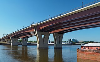
The Tappan Zee Bridge, officially named the Governor Mario M. Cuomo Bridge after the former New York governor, is a twin cable-stayed bridge spanning the Tappan Zee section of the Hudson River between Tarrytown and Nyack in the U.S. state of New York. It was built to replace the original Tappan Zee Bridge, which was located just to the south. The new bridge's north span carries the northbound and westbound automobile traffic of the New York State Thruway, Interstate 87 (I-87) and I-287; it also carries a shared use path for bicycles and pedestrians. The south span carries southbound and eastbound automobile traffic.

The Indian River Inlet Bridge is a cable-stayed bridge located in Sussex County, Delaware, in the United States. It carries four lanes of Delaware Route 1 over the Indian River Inlet between the Indian River Bay and the Atlantic Ocean. The bridge also carries Delaware Bicycle Route 1 across the inlet. The bridge is within Delaware Seashore State Park between Dewey Beach and Bethany Beach. The Indian River Inlet Bridge is maintained by the Delaware Department of Transportation (DelDOT). The bridge is 2,600 feet (790 m) long and 107.66 feet (32.81 m) wide, with a span of 950 feet (290 m) and overhead clearance of 45 feet (14 m).

On May 23, 2013, at approximately 7:00 pm PDT, a span of the bridge carrying Interstate 5 over the Skagit River in the U.S. state of Washington collapsed. Three people in two different vehicles fell into the river below and were rescued by boat, escaping serious injury. The cause of the catastrophic failure was determined to be an oversize load striking several of the bridge's overhead support beams, leading to an immediate collapse of the northernmost span.

