
Bamingui-Bangoran is one of the 20 prefectures of the Central African Republic. It covers an area of 58,200 km2 and had a population of 43,229 as of the 2003 census. The population density of 0.74/km2 is the lowest in the country. The capital is Ndélé.

Lobaye is one of the 20 prefectures of the Central African Republic. Its capital is Mbaïki. Emperor Duy Tân of Vietnam died here on December 26, 1945 in a plane crash. David Dacko, the first and third president of the Central African Republic from 1960–1965 and 1979–1981, was from Lobaye.

Nana-Mambéré is one of the 20 prefectures of the Central African Republic. It covers an area of 26,600 km2 and has a population of 233,666 (2003 census). The capital is Bouar. It was part of Kamerun when it was a German colony between 1884 and 1916.
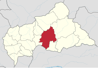
Ouaka is one of the 20 prefectures of the Central African Republic. It borders the Democratic Republic of the Congo, covers an area of 49,900 km2, and has a population of 276,710, giving a population density of 5.5 inhabitants/km2. The capital is Bambari. It is named for the Ouaka River.

Ouham-Pendé is one of the 20 prefectures of the Central African Republic. Its capital is Bozoum. The region contains several ghost towns such as Goroumo, Beogombo Deux and Paoua due to government forces ransacking them and armed bandits killing all the male inhabitants over the years from 2005 to 2008.

Vakaga is one of the 20 prefectures of the Central African Republic. Its capital is Birao. It covers an area of 46,500 km2 and has a population of 52,255. The extremely low population density, 1.1 people/km2, is a result of the capture of the majority of the region's inhabitants by slave-traders from the Sudan in the second half of the nineteenth century. Vakaga is known for its oil reserves.
Mobaye is a settlement with a population of 7,176 in the Basse-Kotto prefecture of Central African Republic. It lies on the Ubangi River.
Obo is the capital of Haut-Mbomou, one of the 14 prefectures of the Central African Republic. It is close to the African Pole of Inaccessibility.
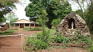
Mbaïki is the capital of Lobaye, one of the 14 prefectures of the Central African Republic. It is situated in the southwest of the country, 107 km from the capital Bangui. Lobaye people and Pygmy people live in the area. There is also a waterfall near the town.

Kaga-Bandoro is a market town and capital of the Nana-Grébizi prefecture of the Central African Republic. It represents the seat of the Roman Catholic Diocese of Kaga–Bandoro. The town has been renamed twice.

Bangassou is a city in the south eastern Central African Republic, lying on the north bank of the Mbomou River. It has a population of 24,447 and is the capital of the Mbomou prefecture. It is known for its wildlife, market, and nearby Bangassou Airport and is linked by ferry to the Democratic Republic of Congo on the south bank. The city is also home to the Roman Catholic Diocese of Bangassou.

Ouango is a town located in the Central African Republic prefecture of Mbomou.

Rafaï is a town and sub-prefecture on the Chinko River, in the Central African Republic prefecture of Mbomou. Its estimated population is about 14,000 people.
Ouadda is a town located in the Central African Republic prefecture of Haute-Kotto.
Bakouma is a sub-prefecture in the prefecture of Mbomou in Central African Republic. The area is known for its prosperity of mineral resources which have for a long time remained unexploited.
Bamingui is a town and sub-prefecture in the Bamingui-Bangoran Prefecture in the northern Central African Republic. It lies on the south bank of the Chari River along National Route 8, 529 kilometres (329 mi) by road northeast of the capital of Bangui. As of 2003 it had a population of 6230 people.
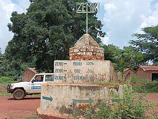
Zemio is a town and sub-prefecture in the Haut-Mbomou prefecture of the south-eastern Central African Republic. Zemio was the former capital of the Sultanate of Zemio before it was abolished in 1923 by France.

Djemah is a town and sub-prefecture in the Haut-Mbomou Prefecture of the south-eastern Central African Republic. It is the least-populous sub-prefecture in the country. The town is largely neglected by the central government since the country gained independence from France in 1960.
Bambouti is a sub-prefecture of Haut-Mbomou in the Central African Republic. The town is abandoned by the country.

Mboki is a town and sub-prefecture in the Haut-Mbomou prefecture of the south-eastern Central African Republic.

