
The Metropolitan Borough of Stepney was a Metropolitan borough in the County of London created in 1900. In 1965 it became part of the London Borough of Tower Hamlets.
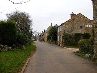
Hanging Houghton is a small village and former civil parish, now in the parish of Lamport, in the West Northamptonshire district, in the ceremonial county of Northamptonshire, England. It is on the A508 road between Brixworth and Lamport. In 1931 the parish had a population of 84.
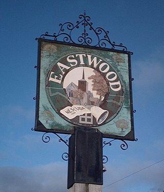
Eastwood is a suburb of the city of Southend-on-Sea and former civil parish, now in the unparished area of Southend-on-Sea, in the Southend on Sea district, in the ceremonial county of Essex, England. Eastwood is sometimes called Eastwood Park, particularly for local elections.

Chopwell is a village and former civil parish, now in the unparished area of Blaydon, in the Gateshead district, in the county of Tyne and Wear, England, 3 miles (4.8 km) west of Rowlands Gill and 1 mile (1.6 km) north of Hamsterley. At the 2011 Census, it had a population of 9,395.

Blendworth is a village and former civil parish, now in the parish of Horndean, in the East Hampshire district of Hampshire, England. It lies 0.4 miles (0.6 km) northeast of Horndean just east off the A3 road.

Tatterford is a village and former civil parish, now in the parish of Tattersett, in the North Norfolk district, in the county of Norfolk, England. The village is 4.8 miles south west of the town of Fakenham, 30.3 miles north west of Norwich and 112 miles north north east of London. The nearest railway station is at Sheringham for the Bittern Line which runs between Sheringham, Cromer and Norwich. The nearest airport is Norwich International Airport. In 1931 the parish had a population of 66.
East Rainton is a village and former civil parish, now in the parish of Hetton, in the Sunderland district, in the county of Tyne and Wear, England. It is situated alongside the A690 road between Sunderland and Durham, near Houghton-le-Spring. In 1931 the parish had a population of 1711. East Rainton was formerly a township and chapelry in the parish of Houghton-le-Spring, from 1866 East Rainton was a civil parish in its own right, on 1 April 1937 the parish was abolished to form Hetton, part also went to Houghton le Spring.

East Marden is a village and former civil parish, now in the parish of Marden, in the Chichester district of West Sussex, England. It is on the spur of the South Downs It is first mentioned in the Domesday Book as Meredone and was given in 1086 to Roger, Earl of Montgomery. The church, St Peters, dates from the 12th century and is still used for worship every other Sunday. Its oldest house today dates back to 1728. The village, some 100 metres above sea level, is in an area of unusually high rainfall. Its most famous landmark is the thatched well on the village green. The population has remained static for over a century. In 1931 the parish had a population of 80. On 1 April 1933 the parish was abolished to form "Marden".

Little Petherick is a village and former civil parish, now in the parish of St Issey, in the Cornwall district, in north Cornwall, England, United Kingdom. It is situated two miles south of Padstow and 6 miles west of Wadebridge. Little Petherick lies in the valley of Little Petherick Creek, a tidal tributary of the River Camel: however, upstream of Little Petherick the creek ceases to be tidal. The village straddles the A389 Wadebridge-Padstow road which crosses the creek at the east end of the village on a Grade II listed 19th century bridge. In 1931 the parish had a population of 178. On 1 April 1934 the parish was abolished and merged with St Issey.

Bushby is a village and former civil parish, now in the parish of Thurnby and Bushby, in the Harborough district, in Leicestershire, England. In 1931 the parish had a population of 336.

North Stoke is a village and former civil parish, now in the parish of Amberley, in the Horsham district of West Sussex, England. It is just over 2 miles (3 km) north of Arundel and 0.7 miles (1 km) south of Amberley railway station, and is at the end of a no through road from the station. In 1931 the parish had a population of 70. On 1 April 1933 the parish was abolished and merged with Amberley.

South Ambersham is a hamlet and former civil parish, now in the parish of Graffham, in the Chichester district of West Sussex, England. It lies 0.7 miles (1.2 km) south of the A272 road and 2 miles (3.2 km) east of Midhurst. Until 1844 South Ambersham was a detached part of Hampshire and was a tithing of the parish of Steep, in 1844 it became a separate civil parish, until 1972 when it was abolished and merged with Graffham. In 1961 the parish had a population of 117.

Aldrington is an area and former civil parish, now in the unparished area of Hove, in the Brighton and Hove district of the ceremonial county of East Sussex, England. For centuries it was meadow land along the English Channel stretching west from the old village of Hove to the old mouth of the River Adur, and it is now a prosperous residential area integrated within Hove.

Quarles is a hamlet and former civil parish, now in the civil parish of Holkham, in the North Norfolk district, in the county of Norfolk, England. The hamlet is 4 miles (6.4 km) south-west of Wells-next-the-Sea, 34 miles (55 km) north-west of Norwich and 122 miles (196 km) north-north-east of London. The nearest railway station is Sheringham for the Bittern Line which runs between Sheringham, Cromer and Norwich. The nearest airport is Norwich International Airport. The hamlet is just south of the Holkham Estate and consists of six houses and one farm. In 1931 the civil parish had a population of 38.
Alethorpe is a deserted medieval village site and former civil parish, now in the parish of Little Snoring, in the North Norfolk district, in the county of Norfolk, England. It lies south-east of Little Snoring, around 2 miles (3.2 km) north-east of the town Fakenham and 23 miles (37 km) north-west of Norwich to the north of the A148 road. The village, which is one of around 200 lost settlements in Norfolk, was abandoned in the 16th century, probably as the consequence of the land being enclosed by the landlord of that time. It is occasionally referred to as Althorp in historical literature. In 1931 the parish had a population of 1.

Naughton is a village and former civil parish, now in the civil parish of Nedging-with-Naughton, in the Babergh district, in the county of Suffolk, England. It is 10 miles (16 km) north-west of Ipswich and 7 miles (11 km) south-west of Stowmarket. It was historically within the Cosford Hundred of Suffolk. The civil parish was merged with Nedging on 1 April 1935 to create "Nedging with Naughton". In 1931 the civil parish had a population of 98.

Plaitford is a small village and former civil parish, now in the parish of Melchet Park and Plaitford, in the Test Valley district of Hampshire, England. Its nearest town is Romsey, which lies approximately 4.9 miles (7.8 km) east from the village; the large village of West Wellow is immediately west of Plaitford. In 1931 the parish had a population of 195.
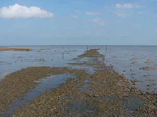
The Broomway, also formerly called the "Broom Road", is a public right of way over the foreshore at Maplin Sands off the coast of Essex, England. Most of the route is classed as a byway open to all traffic, with a shorter section of bridleway. When the tide is out, it provides access to Foulness Island, and indeed was the only access to Foulness on foot, and the only access at low tide, until a road bridge was built over Havengore Creek in 1922.
West Bilney is a village and former civil parish on the A47 road, 32 miles (51 km) west of Norwich, now in the parish of East Winch, in the King's Lynn and West Norfolk district, in the county of Norfolk, England. In 1931 the parish had a population of 188. Its church is dedicated to St Cecilia.

Bowers Gifford and North Benfleet is a civil parish in the Basildon district, located within the county of Essex, England. The parish includes the villages of Bowers Gifford and North Benfleet. The parish was formed on 1 April 2010. In 2021 the parish had a census recorded population of 1962. There are 7 listed buildings in Bowers Gifford and North Benfleet. The local council is Bowers Gifford and North Benfleet Parish Council.
