
Mount Foresta is an 11,000+ ft multi-peak massif located in Wrangell–St. Elias National Park, in the Saint Elias Mountains of Alaska in the United States. Rising high above the lower western margin of the Hubbard Glacier, the summit of Mount Foresta is just over nine miles (14 km) from tidewater at Disenchantment Bay, 12 mi (19 km) northwest of Mount Seattle, 14.5 mi (23 km) southeast of Mount Vancouver, and 46 mi (74 km) north of Yakutat.
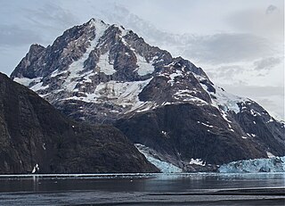
Mount Abbe is an 8200+ feet double summit mountain located in the Fairweather Range of the Saint Elias Mountains, in southeast Alaska. The peak is situated near the terminus of the Johns Hopkins Glacier, within Glacier Bay National Park and Preserve, 100 mi (161 km) northwest of Juneau, and 8.2 mi (13 km) northeast of Mount Orville. Although modest in elevation, relief is significant since the mountain rises up from tidewater in less than two miles. Mount Abbe is often seen and photographed with the Johns Hopkins Glacier, which is a popular destination for cruise ships. The mountain was named in 1936 by William Osgood Field and William Skinner Cooper, of the American Geographical Society, for Cleveland Abbe Jr., (1872-1934), an American geographer. Abbe received a Ph.D. in 1898 from Johns Hopkins University. The Gilman Glacier and Clark Glacier on the mountain's slopes were named for Daniel Coit Gilman, the institution's first president, and William Bullock Clark who was a professor of geology at the university. The mountain's name was officially adopted in 1937 by the United States Geological Survey. The first ascent of the south summit was made June 11, 1977, by Jim Wickwire and Dusan Jagersky via the Southeast Face. Three days later, Dusan Jagersky was killed while descending an unnamed peak. The first ascent of the north summit was made July 14, 1991, by Walter Gove and William Pilling. The months May through June offer the most favorable weather for climbing Mount Abbe, but it's a challenging climb in any conditions, with few attempts.

Mount Cooper is a 6780-foot (2067-meter) mountain summit located in the Fairweather Range of the Saint Elias Mountains, in southeast Alaska. The peak is situated in Glacier Bay National Park and Preserve at the entrance to Johns Hopkins Inlet, 100 mi (161 km) northwest of Juneau, and 5.6 mi (9 km) northeast of Mount Abbe, which is the nearest higher peak. Although modest in elevation, relief is significant since the mountain rises up from tidewater in less than two miles. Mount Cooper can be seen from Johns Hopkins Inlet which is a popular destination for cruise ships. The mountain's name was proposed in the 1950s for William Skinner Cooper (1884-1978), a plant ecologist who performed vegetation-glacier relationship studies in the Glacier Bay area, and was chairman of the committee of scientists which proposed establishing Glacier Bay National Monument. The mountain's name was officially adopted in 1980 by the United States Geological Survey following Cooper's death. The months May through June offer the most favorable weather for climbing Mount Cooper.
Mount Abdallah is a prominent 6,210-foot (1,893-meter) mountain summit located in the Alsek Ranges of the Saint Elias Mountains, in southeast Alaska. The mountain is situated in Glacier Bay National Park and Preserve, as the highest point between Tarr Inlet and Rendu Inlet, 93 mi (150 km) northwest of Juneau, and 10.5 mi (17 km) southeast of Mount Barnard, which is the nearest higher peak. Although modest in elevation, relief is significant since the mountain rises up from tidewater in less than three miles. The mountain was named in 1892 by Harry Fielding Reid, an American geophysicist, who in 1892 hired a small crew of men for an expedition to study glaciology in Glacier Bay. There is no record of who Reid named this mountain for, but a member of his expeditionary crew who accompanied him might be a possibility. The months May through June offer the most favorable weather for viewing Mount Abdallah. Weather permitting, Mount Abdallah can be seen from Glacier Bay, which is a popular destination for cruise ships.

Mount La Perouse is a 10,728-foot glaciated mountain summit located in the Fairweather Range of the Saint Elias Mountains, in southeast Alaska, United States. The peak is situated in Glacier Bay National Park, 4 mi (6 km) southeast of Mount Dagelet, 7.6 mi (12 km) south-southeast of Mount Crillon which is the nearest higher peak, and 28.6 mi (46 km) southeast of Mount Fairweather, which is the highest peak in the Fairweather Range. Topographic relief is significant as the mountain rises up from tidewater in less than nine miles. The mountain was named in 1874 by William Healey Dall of the U.S. Geological Survey, for Jean-François de Galaup, comte de Lapérouse (1741–1788), a French navigator who explored this coastal area in 1786. The first ascent of the peak was made in 1953 by USGS party consisting of James Seitz, Karl Stauffer, Rowland Tabor, Rolland Reid, and Paul Bowen. On February 16, 2014, a colossal 68 million ton landslide broke free from the flanks of Mt. La Perouse and flowed nearly 4.6 miles from where it originated. The months May through June offer the most favorable weather for climbing and viewing.

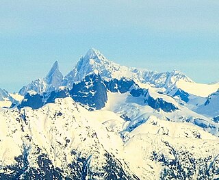
Mount Bertha is a 10,204-foot glaciated mountain summit located in the Fairweather Range of the Saint Elias Mountains, in southeast Alaska, United States.

Sourdough Peak is a 6,201-foot mountain summit located at the southern edge of the Wrangell Mountains, in the U.S. state of Alaska. The peak is situated in Wrangell-St. Elias National Park and Preserve, 7 mi (11 km) east-southeast of McCarthy, on the north bank of the Nizina River. The peak is notable for a rock glacier on its south slope. The peak's name was used by early prospectors as reported in 1908 by the USGS. A "sourdough" is defined as an experienced prospector or an old-timer in the western US or Canada, because they always carried sourdough starter with them. Sourdough Peak's nearest higher neighbor is Porphyry Mountain, 5.1 miles to the northwest.

Castle Peak is a 10,190-foot mountain summit located in the Wrangell Mountains, in the U.S. state of Alaska. The peak is situated in Wrangell-St. Elias National Park and Preserve, 21 mi (34 km) northwest of McCarthy, and 9.3 mi (15 km) south of Mount Blackburn on the south margin of the Kuskulana Glacier valley. Precipitation runoff from the mountain drains into Kuskulana River and Lakina River which are both tributaries of the Chitina River. The peak's descriptive name was used by early prospectors as reported in 1901 by the US Geological Survey.

Mount Merriam is a prominent 5,083-foot (1,549-meter) mountain summit located in Glacier Bay National Park and Preserve, in the Alsek Ranges of the Saint Elias Mountains, in southeast Alaska. The mountain is situated 75 mi (121 km) northwest of Juneau, 3.1 mi (5 km) south of Mount Wordie, 3.5 mi (6 km) north of Black Cap Mountain, and 13.4 mi (22 km) southeast of Mount Abdallah which is the nearest higher peak. Although modest in elevation, relief is significant as the mountain rises up from tidewater in less than three miles, and it ranks 85th in prominence for all peaks in Alaska.

Mount Wordie is a 4,700+ foot mountain summit located in Glacier Bay National Park and Preserve, in the Alsek Ranges of the Saint Elias Mountains, in southeast Alaska. The mountain is situated 80 mi (129 km) northwest of Juneau, 4 mi (6 km) south of Carroll Glacier, and 3.1 mi (5 km) north of Mount Merriam which is the nearest higher peak. Although modest in elevation, relief is significant as the mountain rises up from tidewater in less than two miles. Precipitation runoff from the mountain drains into Glacier Bay Basin. Weather permitting, Mount Wordie can be seen from Queen Inlet and Wachusett Inlet of Glacier Bay, which is a popular destination for cruise ships.

Mount Tom White is a prominent 11,191-foot glaciated mountain summit located in the Chugach Mountains, in the U.S. state of Alaska. The remote peak is situated on land managed by Chugach National Forest, 72 mi (116 km) northeast of Cordova, and 20 mi (32 km) north of the Bering Glacier, North America's largest glacier. The mountain lies within the Copper River drainage basin, and is the eighth-highest major peak in the Chugach Mountains. Topographic relief is significant as it ranks 17th in prominence for all peaks in Alaska, and 52nd for all North America peaks. The first ascent of the mountain was made in 1973 by Story Clark, Chris Hall, Tom Kizzia, William Resor, Sarah Robey, and Don White.

Donoho Peak is a 6,696-foot-elevation mountain summit located in the Wrangell Mountains, in the U.S. state of Alaska. The peak is situated in Wrangell-St. Elias National Park and Preserve, 6 mi (10 km) north-northwest of Kennecott, and 9 mi (14 km) north of McCarthy, at the confluence of the Kennicott Glacier and Root Glacier. The peak's name was reported in 1931 by the United States Geological Survey. The mountain lies within the Copper River drainage basin. Bears frequent the Donoho Peak and Donoho Lakes area. An ascent of the mountain involves 14 miles round-trip from Kennecott to the summit, including crossing the Root Glacier and gully scramble via the south aspect of the mountain. Ruins of the Regal Mine remain at an elevation of 5,440 feet on the south slope of the mountain. Only small amounts of copper ore were ever produced, however. On a clear day the summit of Donoho Peak offers views of Mount Blackburn to the northwest and the Stairway Icefall on Regal Mountain to the north-northeast.

Porphyry Mountain is a prominent 6,375-foot mountain summit located in the Wrangell Mountains, in the U.S. state of Alaska. The peak is situated in Wrangell-St. Elias National Park and Preserve, immediately southeast of Kennecott, 4 mi (6 km) northeast of McCarthy, and, 5 mi (8 km) northwest of Sourdough Peak. Precipitation runoff from the mountain drains into tributaries of the Nizina River, which in turn is part of the Copper River drainage basin. The peak is notable for a rock glacier on its north slope. The mountain was so named because it is largely composed of porphyry, which is a very hard igneous rock. The mountain's local name was reported in 1908 by the U.S. Geological Survey. On a clear day the summit of Porphyry Mountain offers views of Donoho Peak, Kennicott Glacier, and Mount Blackburn to the northwest, and Fireweed Mountain to the west.

Mount Huxley is a 12,216-foot glaciated mountain summit located in the Saint Elias Mountains of Wrangell-St. Elias National Park and Preserve, in the U.S. state of Alaska. The remote peak is situated 75 mi (121 km) northwest of Yakutat, and 8.7 mi (14 km) west-northwest of Mount Saint Elias. The peak rises above the Columbus Glacier and Bagley Icefield to its north, the Tyndall Glacier to the south, and the Yahtse Glacier to the west. Precipitation runoff from the mountain drains into the Gulf of Alaska. The mountain was named in 1886 by English mountaineer Harold Ward Topham for Thomas Henry Huxley (1825-1895), an English biologist. The mountain was officially named Huxley Peak in 1917, but the name was officially changed to Mount Huxley in 1968 by the U.S. Board on Geographic Names. The first ascent of the peak was made June 9, 1996 by Paul Claus who landed his plane at 11,500 feet elevation on the western flank and climbed the remaining distance to the summit. The second ascent of Mt. Huxley, and first complete ascent from base to summit, was made in June 2018 by Scott Peters, Andrew Peter, and Ben Iwrey starting from the Columbus Glacier.

Mount Chitina is an 8,424-foot (2,568-meter) mountain summit located in the Saint Elias Mountains of Wrangell-St. Elias National Park and Preserve, in the U.S. state of Alaska. The remote peak is situated 113 mi (182 km) northwest of Yakutat, and 40 mi (64 km) northwest of Mount Logan. Mount Chitina rises 5,000+ ft above the confluence of the Chitina Glacier and the Logan Glacier. Precipitation runoff from the mountain drains into the Chitina River, which in turn is part of the Copper River drainage basin. The first ascent of the peak was made September 24, 1988, by Danny Kost and Donnie Hunton via the west ridge. The mountain's name is derived from the Chitina Glacier located at the base of the north slope, and was first published on a Canadian topographic map in 1958.
Mount Grace is a remote 10,540-foot (3,213 m) glaciated mountain summit located in the Chugach Mountains, in the U.S. state of Alaska. The unofficially named peak is situated 63 mi (101 km) east of Anchorage, 6 mi (10 km) north of College Fjord, 3.35 mi (5 km) east of Mount Goode, and 9.37 mi (15 km) southwest of Mount Marcus Baker, on land managed by Chugach National Forest.

Mount Malaspina is a 3,776-metre (12,388-foot) mountain summit in Yukon, Canada.
Mount Leeper is a 9,603-foot-elevation (2,927-meter) mountain summit in Alaska, United States.
Mount Burkett is a 9,730-foot-elevation (2,966-meter) mountain summit in Alaska, United States.

Mount Chichantna is a 10,893-foot-elevation (3,320-meter) mountain summit in Alaska.


