Hazara Division

Last updated

Hazara Division
ہزارہ ڈویژن
هزاره څانګه
Hazara Division, Khyber Pakhtunkhwa.png
Map of Hazara Division
Country Pakistan
Province Khyber Pakhtunkhwa
Headquarters Abbottabad
Districts 9
Government
  TypeDivisional Administration
  CommissionerAamir Sultan Tareen (BPS-20 PAS)
  Regional police officerTahir Ayub Khan (BPS-20 PSP)
Area
[1]
  Total17,064 km2 (6,588 sq mi)
Population
 (2017)
  Total5,325,121 [2]
Time zone UTC+5 (PST)
Website chd.kp.gov.pk

Hazara Division is an administrative division of the Khyber Pakhtunkhwa province of Pakistan. It is located along the Indus River and comprises eight districts: Abbottabad, Mansehra, Haripur, Battagram, Upper Kohistan, Kolai-Palas, Lower Kohistan, Torghar and most recently created Allai District. CNIC code of Hazara Division is 13.

Contents

Location

Hazara Division is bordered by Malakand and Mardan Divisions to the west, Rawalpindi Division (Punjab) and Islamabad Capital Territory to the south, Azad Kashmir to the east, and Gilgit-Baltistan to the north.

History

On the dissolution of West Pakistan in 1970, Hazara District and the two tribal agencies were merged to form the new Hazara Division with its capital at Abbottabad. The division was initially composed of two districts (Abbottabad, and Mansehra) but within a few years, Haripur district was spun off from Abbottabad District and Batagram District was spun off from Mansehra District.

Hazara remained a district until its conversion into a division in 1976. In October 1976, Mansehra was given the status of a full-fledged district, which consisted of Mansehra and Batagram tehsils. Subsequently, in July 1991, Haripur Tehsil was separated from Abbottabad and made into a district. Thus only the old Tehsil of Abbottabad remained, which was declared as Abbottabad District.

In 2000, administrative divisions were abolished and the fourth-tier districts were raised to become the new third tier of government in Pakistan. At abolition it contained the 8 districts: [3]

Eventually, with all the administrative divisions being restored back in 2008, Hazara Division has returned.

Demographics

According to the 2017 census, Hazara Division division had a population of 5,325,121. [2]

Districts

Hazara Division contains the following districts: [4]

See also

Related Research Articles

<span class="mw-page-title-main">Abbottabad District</span> District in Khyber Pakhtunkhwa, Pakistan

Abbottabad District is a district in the Khyber Pakhtunkhwa province of Pakistan. It is part of the Hazara Division and Hazara region covers an area of 1,969 km2, with the city of Abbottabad being the principal town. Neighbouring districts include Mansehra to the north and Haripur to the west in Khyber Pakhtunkhwa, Muzaffarabad to the east in Azad Jammu and Kashmir and Rawalpindi to the south in the Punjab province.

<span class="mw-page-title-main">Haripur District</span> Districts in Pakistan

Haripur District is a district in the Hazara Division of Khyber Pakhtunkhwa, Pakistan.

<span class="mw-page-title-main">Mansehra District</span> District in Khyber Pakhtunkhwa, Pakistan

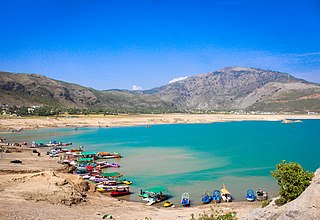
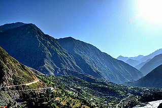
Mansehra District is a district in the Hazara Division, Khyber Pakhtunkhwa, northern Pakistan. Mansehra city serves as the headquarters of the district.

<span class="mw-page-title-main">Kohistan District, Pakistan</span> District in Khyber Pakhtunkhwa, Pakistan

Kohistan, also called Indus Kohistan, was an administrative district within the Hazara region of Khyber Pakhtunkhwa, Pakistan. In 2014, it was bifurcated into two districts: Upper Kohistan and Lower Kohistan. In 2017, the Lower Kohistan District was further bifurcated and a district Kolai-Palas was established. It covered an area of 7,492 square kilometres (2,893 sq mi) and had a population of 472,570 according to the 1998 Census. Geographically, Kohistan stretched from Gilgit-Baltistan in the north to the Mansehra District in the east to the Battagram District and Shangla and Swat districts in the west.

<span class="mw-page-title-main">Torghar District</span> District of Khyber Pakhtunkhwa in Pakistan

Torghar District formerly known as Kala Dhaka is a district in the Hazara Division of the Khyber Pakhtunkhwa province of Pakistan. It was officially separated from Mansehra District in 2011 under Article 246 of the Constitution of the Islamic Republic of Pakistan.

<span class="mw-page-title-main">Allai Tehsil</span> Tehsil in Khyber Pakhtunkhwa, Pakistan

Allai is a tehsil of Allai District in Pakistan's Khyber-Pakhtunkhwa province. It is home to the Allai Valley and district headquarters. Prince Muhammad Nawaz Khan Swati is the current "Chief of Allai Valley".

<span class="mw-page-title-main">Battagram District</span> District & City in Khyber Pakhtunkhwa, Pakistan

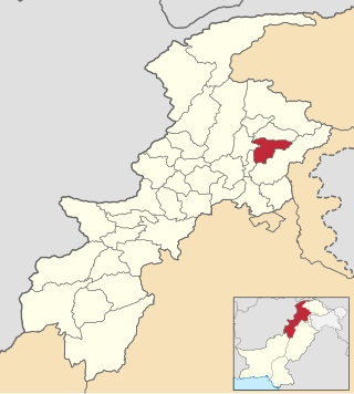
Battagram is a district in Hazara Division of Khyber Pakhtunkhwa province in Pakistan. The headquarter is Battagram, which is about 75 km from Mansehra.

<span class="mw-page-title-main">Hazara District</span>

Hazara District was a district of Peshawar Division in the North-West Frontier Province of Pakistan. It existed until 1976, when it was split into the districts of Abbottabad and Mansehra, with the new district of Haripur subsequently splitting off from Abbottabad, and Battagram and Torghar – from Mansehra.

Battagram Tehsil is an administrative subdivision (Tehsil) of the Battagram District in the Khyber Pakhtunkhwa province of Pakistan. It serves as the Tehsil headquarters and covers a total area of 300 square miles (780 km2). Battagram Tehsil merged into Pakistan as an administrative region before being raised to the status of a district in 1993. On October 8, 2005, a 7.6 magnitude earthquake in Kashmir badly affected the area.

Hazarewals or Hazarawals also known as Hazara is term used for the multi-ethnic predominantly Hindko and Shina speaking community belonging to the Hazara region of Khyber Pakhtunkhwa.

<span class="mw-page-title-main">Swatiabad</span>

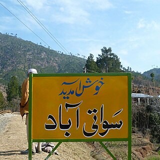
Swatiabad “سواتی آباد” is a village in Kathai union council, Tehsil Oghi, of Mansehra District in Khyber Pakhtunkhwa province of Pakistan. 9.2 km from main city of Oghi on Battal Road, It lies in an area affected by the 2005 Balkot earthquake. 34°31'42.35" N 73°06'04.19" E

<span class="mw-page-title-main">Board of Intermediate and Secondary Education, Abbottabad</span> Examination board in Khyber Pakhtunkhwa, Pakistan

The Board of Intermediate and Secondary Education, Abbottabad, more commonly known as BISE Abbottabad, is an intermediate and secondary education governmental board located in Abbottabad, Khyber Pakhtunkhwa, Pakistan. It is authorized with financial and administrative authority to organize, manage, regulate, develop and control intermediate and secondary education in general and accomplish examinations in the institutions affiliated with it. BISE Abbottabad came into being as a result of the break-up of Peshawar Board in 1990 under the North West Frontier Province Board of Intermediate and Secondary Education Act 1990. The organisation building is located on Murree Road, Abbottabad.

<span class="mw-page-title-main">Lower Kohistan District</span> District of Khyber Pakhtunkhwa in Pakistan

Lower Kohistan District is a district in the Hazara Division of the Khyber Pakhtunkhwa province of Pakistan. Pattan is the district headquarters of Lower Kohistan.

<span class="mw-page-title-main">Upper Kohistan District</span> District of Khyber Pakhtunkhwa in Pakistan

Upper Kohistan District is a district in the Hazara Division of the Khyber Pakhtunkhwa province of Pakistan.

<span class="mw-page-title-main">Kolai-Palas District</span> District of Khyber Pakhtunkhwa in Pakistan

Kolai-Pallas District is a district in the Hazara Division of the Khyber Pakhtunkhwa province of Pakistan. It was a sub-division of the Kohistan district within the Hazara division till it attained the status of a separate district in 2017.

Abaseen or Abasin Division is a proposed division in Pakistan's Khyber Pakhtunkhwa province, compromising seven districts: Battagram, Allai, Kolai-Palas, Upper Kohistan, Lower Kohistan, Shangla, and Torghar. The area is located on both sides of the Indus River, which is known in Pashto and other local languages as Abaseen.

<span class="mw-page-title-main">Allai District</span> District of Khyber Pakhtunkhwa, Pakistan

Allai District is a district in the Hazara Division of Khyber Pakhtunkhwa, Pakistan.

References

  1. "1951 - 1998 POPULATION OF ADMINISTRATIVE UNITS (AS ON 1st MARCH 1998)" (PDF). 1951-98 Population of Administrative Units (As on 1 March 1998).pdf. POPULATION CENSUS ORGANIZATION STATISTICS DIVISION GOVERNMENT OF PAKISTAN. January 2002. Archived (PDF) from the original on 23 August 2020. Retrieved 25 August 2020.
  2. 1 2 "PROVINCE WISE PROVISIONAL RESULTS OF CENSUS - 2017" (PDF). PAKISTAN TEHSIL WISE FOR WEB CENSUS_2017.pdf. Pakistan Bureau of Statistics. Archived from the original (PDF) on 16 June 2020. Retrieved 16 June 2020.
  3. Divisions/Districts of Pakistan Archived 2006-09-30 at the Wayback Machine
    Note: Although divisions as an administrative structure has been abolished, the election commission of Pakistan still groups districts under the division names
  4. Divisions/Districts of Pakistan Archived 2006-09-30 at the Wayback Machine
    Note: Although divisions as an administrative structure has been abolished, the election commission of Pakistan still groups districts under the division names
  5. "complete history of Haripur Pakistan in urdu". ALFURQAN URDU: LATEST PAKISTAN NEWS, WORLD NEWS. 8 October 2023. Retrieved 13 December 2023.