
Dunbar is a town on the North Sea coast in East Lothian in the south-east of Scotland, approximately 30 miles east of Edinburgh and 30 mi (50 km) from the English border north of Berwick-upon-Tweed.

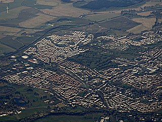
Falkirk is a large town in the Central Lowlands of Scotland, historically within the county of Stirlingshire. It lies in the Forth Valley, 23.3 miles (37.5 km) north-west of Edinburgh and 20.5 miles (33.0 km) north-east of Glasgow.
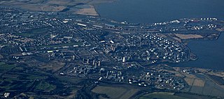
Grangemouth is a town in the Falkirk council area, Scotland. Historically part of the county of Stirlingshire, the town lies in the Forth Valley, on the banks of the Firth of Forth, 3 miles (4.8 km) east of Falkirk, 5 miles (8.0 km) west of Bo'ness and 13 miles (20.9 km) south-east of Stirling. Grangemouth had a resident population of 17,906 according to the 2001 Census. Preliminary figures from the 2011 census reported the number as 17,373.
Stenhousemuir is a town in the Central Lowlands of Scotland. It lies within the Falkirk council area of Scotland. The town is 2 miles north-northwest of Falkirk and directly adjoins to Larbert in the west, where the nearest rail access is located. The villages of Carron and Carronshore adjoin Stenhousemuir to the east but to a lesser extent. At the 2001 census it showed that it had a resident population of 10,351 but according to a 2009 estimate this was revised to around 10,190 residents. The combined population of the four localities in 2011 was 24,722, representing about 15% of the Falkirk council area total.

Milnathort is a small town in the parish of Orwell in the county of Kinross-shire, Scotland and since 1996, the local council area of Perth and Kinross. The smaller neighbour of nearby Kinross, Milnathort has a population of around 2,000 people. It is situated amidst countryside at the foot of the Ochil Hills, and near the north shore of Loch Leven. From 1977 it became more easily accessible due to the development of the M90 motorway. The name comes from the Gaelic maol coirthe meaning "bare hill of the standing stones".

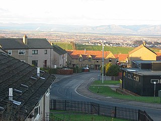
Polmont is a village in the Falkirk council area of Central Scotland. It lies towards the east of the town of Falkirk, north of the Union Canal, which runs adjacent to the village.

Larbert is a small town in the Falkirk council area of Scotland. The town lies in the Forth Valley above the River Carron which flows from the west. Larbert is three miles from the shoreline of the Firth of Forth and 2+1⁄2 miles northwest of Falkirk, the main town in the area. The village of Stenhousemuir lies directly east of Larbert, with both settlements being contiguous and sharing certain public amenities with one another.

Gullane is a town on the southern shore of the Firth of Forth in East Lothian on the east coast of Scotland. There has been a church in the village since the ninth century. The ruins of the Old Church of St. Andrew built in the twelfth century can still be seen at the western entrance to the village; the church was abandoned after a series of sandstorms made it unusable, and Dirleton Parish Church took its place.

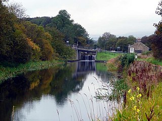
Bonnybridge is a village in the Falkirk council area of Scotland. It is 4.0 miles (6.4 km) west of Falkirk, 5.3 miles (8.5 km) north-east of Cumbernauld and 8.3 miles (13.4 km) south-southwest of Stirling. The village is situated near the Bonny Water which runs through the town and lies north of the Forth and Clyde Canal. To the south-east of Bonnybridge is a well-preserved section of the Antonine Wall, and the remnants of Rough Castle Fort, the most complete of the surviving Roman forts of the wall.
Banknock is a village within the Falkirk council area in Central Scotland. The village is 6.7 miles (10.8 km) west-southwest of Falkirk, 3.9 miles (6.3 km) east-northeast of Kilsyth and 3.0 miles (4.8 km) north-northeast of Cumbernauld.

Dunipace is a village in the west of the Falkirk council area of Scotland. The village is 6.3 miles (10.1 km) south of Stirling and 5.3 miles (8.5 km) north-west of Falkirk. The village is situated on the north bank of the River Carron and adjoins the town of Denny, to the south of the river. Dunipace is part of the historic county of Stirlingshire.
Muir of Ord is a village in the council area of Highland of Scotland. It is situated near the western boundary of the Black Isle, about 9 miles (14 km) west of the city of Inverness and 5+1⁄2 miles (9 km) south of Dingwall. The village has a population of 2,840 and sits 35 metres (115 ft) above sea level. The Scottish geologist, Sir Roderick Murchison was born in the village in 1792.

Brightons is a village in the east of the Falkirk council area of Scotland. It is 2.7 miles (4.3 km) south-east of Falkirk, 2.2 miles (3.5 km) south of Grangemouth and 4.6 miles (7.4 km) east of Linlithgow. It is surrounded by the villages of Polmont, Wallacestone and Rumford. It is central within the Braes area of Falkirk which makes it “Capital of the Braes”

Reddingmuirhead is a village located in Stirlingshire, Falkirk council area, Central Scotland. A few hundred yards uphill from the village of Redding, it is between Shieldhill and Brightons.

Dennyloanhead is a village in the Falkirk council area, Central Scotland, that is between Head of Muir and Longcroft. Dennyloanhead had a fingerpost announcing that it is 294 miles from John o' Groats. Old maps show it is 9 miles from Stirling and 5 miles from Falkirk.

Glen Village is a settlement in the Falkirk council area of Scotland, situated at the southern end of Callendar Park, and around 1 mile (1.6 km) south of Falkirk town centre. It adjoins the housing estate of Hallglen, with the two localities counted together in most official statistics.
Shieldhill is a village within the Falkirk council area in Central Scotland. The village is 2.0 miles (3.2 km) south-east of Falkirk, 2.4 miles (3.9 km) south-west of Polmont and 0.5 miles (0.8 km) north of the village of California.

Carronshore is a village in the Falkirk council area of Scotland. The village lies in the Forth Valley, 1.7 miles (2.7 km) north of the town of Falkirk and directly to the east of neighbouring village Carron.

California is a former pit village in the Falkirk council area of Scotland. It lies between Shieldhill and Avonbridge on the uplands which form the southern edge of the council area.
The Falkirk Braes is a geographical and sociopolitical entity within the Falkirk local authority area in Scotland. The population is approximately 32,000 (2018), about 20% of the total for Falkirk council area.

