Headley Down

Last updated

Headley Down
Hampshire UK location map.svg
Red pog.svg
Headley Down
Location within Hampshire
OS grid reference SU840361
Civil parish
District
Shire county
Region
Country England
Sovereign state United Kingdom
Post town Bordon
Postcode district GU35 8
Dialling code 01428
Police Hampshire and Isle of Wight
Fire Hampshire and Isle of Wight
Ambulance South Central
UK Parliament
List of places
UK
England
Hampshire
51°07′08″N0°47′58″W / 51.11892°N 0.79943°W / 51.11892; -0.79943

Headley Down is a village within the civil parish of Headley in the East Hampshire district of Hampshire, England, bounded on two sides by Ludshott Common, a National Trust heathland reserve. The village began with a few buildings in the 1870s and became a thriving community that in the 20th century outgrew the parish centre of Headley.

Contents

Headley Down is 36 miles (58 km) south west of London and 1 mile (1.6 km) east of Headley village centre. Nearby are the villages of Grayshott to the east and Churt to the north.

History

Ludshott Common (formerly Headley Common) and Headley were both listed in the Domesday Survey of 1086. [1] The area was called Headley Down on maps as early as 1801, and Headley Common on an Ordnance Survey map from the late 19th century, and from about the 1870s houses began to be built by people wishing to live or holiday in the healthy environment for which the Hindhead area was notable. [2] It was part of the large and much older Wishanger Manor Estate, the records of which go back at least to 1167. [3] [4] The name Headley Down was not mentioned in the 1908 History of the County of Hampshire, but Headley Common is mentioned as an area likely to become popular as a residential neighbourhood. [5] The side-roads in Headley Down were laid out in a grid system at least as early as 1909, [6] rather than radiating out from a central point such as a church.

The Land of Nod estate predates Headley Down, possibly established in the early 18th century; an owner of the estate believed its name derived from an earlier incumbent by the name of Cane or Keyne, an excommunicant, and is a reference to the biblical story of Cain's banishment; the Elizabethan house Cain Manor and Cain Farm are associated with the estate, [7] which lies mainly to the north of the village and had originally formed a part of the Manor of Wishanger. [5] [8] Kelly's Directory of 1895 lists J Henry Christian as a private resident of the Land of Nod. [9]

Map of Hampshire Sheet 036, Ordnance Survey, 1866-1889.jpg
Extract from Map of Hampshire Sheet 036, Ordnance Survey 1st series (scale 1:10560), 1866-1889 showing Headley Common and The Land of Nod

Headley Down was formally named in March 1923 when the Post Office proclaimed that "the official name of the Telephone Call Office which has been established on Stone Hill will be Headley Down". A temporary wooden building in Carlton Road erected in the 1960s housed the post office, where it remained until incorporated into Whittle's store (subsequently Londis) in Eddeys Lane. [10]

During the Second World War the area was home to several camps for Canadian soldiers. Erie camp was a military detention centre [11] and was built on the Land of Nod estate owned by Major L Whitaker; it was designated by the War Office as a "Military Prison and Detention Barracks" from at least 1946 to 1948. [12] The camp was subsequently occupied by civilians and gradually replaced by an estate of 350 houses and named Heatherlands. The estate was completed by 1977. From early April 1944, 107 Regiment Royal Armoured Corps (King's Own) trained with Churchill tanks on Headley Down in preparation for the invasion of Normandy. [13] There were other military units based on Headley Down: on the current Windmill Estate, at the back of The Mount, and down Headley Hill Road and Barley Mow Hill. [14]

In the 1950s Alfred Whittle opened a general store, butcher's and coal merchant in Eddeys Lane [15] to accommodate Headley Down's increasing post-war population. The store and post office closed in 2015 after 65 years' service to the village. [16]

"Penryn" was a home for children, mainly from London, in the post-war period until the 1980s when it was replaced by private housing, now called Penryn Drive. [17]

Heatherlands estate houses approximately one fifth of the Headley parish population. In 2006, Heatherlands/Headley Down was considered to be the most deprived ward in East Hampshire. EHDC expressed the view that Headley's Parish Plan was not sufficiently inclusive of the whole parish. The Parish Council set out to explore ways to improve social inclusion and in 2007 produced a report with recommendations for action. [18]

Amenities

Transport

The main through road is the B3002 (Beech Hill/Grayshott Road) connecting Headley Down to the A333 (the old A3) at Hindhead via Grayshott to the east, and to the A325 at Bordon, via Headley and Lindford to the west. [19]

The nearest railway station is 3.3 miles (5.3 km) south of the village, at Liphook.

The bus route serving Headley Down is Stagecoach 23, Alton to Haslemere. [20]

Shops

Education

There is no school in Headley Down; the nearest for up to 11 year olds is The Holme Church of England Controlled Primary School in Headley village. [22]

Community

St Francis Church and Hall St Francis Church and Hall at Headley Down - geograph.org.uk - 1705075.jpg
St Francis Church and Hall

Environment

Ludshott Common, adjoining the eastern and southern boundary of the village, is one of the largest remaining areas of heathland in East Hampshire. A National Trust property, it covers 285 ha (705 acres) and is designated a Site of Special Scientific Interest (SSSI) and Special Protection Area (SPA) due to the number of endangered species, including woodlark, nightjar and Dartford warbler. There is also a great variety of spider and butterfly species, including the silver-studded blue, grayling and green hairstreak. [30]

Fuller's Vale wildlife pond in early April Fullers Vale pond 2023 (Tony Holkham).jpg
Fuller's Vale wildlife pond in early April

Pond Road is so named for a pond that existed up until the 1970s when it was drained and subsequently attracted fly-tipping. Local residents remembered it had previously contained a wide variety of insect life, amphibians and fish, and attracted kingfishers. With the aid of local and county council grants it was re-established in 2003 and is now known as Fuller's Vale Wildlife Pond. [31]

Notable people

Related Research Articles

<span class="mw-page-title-main">Hindhead</span> Human settlement in England

Hindhead is a village in the Waverley district of the ceremonial county of Surrey, England. It is the highest village in the county and its buildings are between 185 metres (607 ft) and 253 metres (830 ft) above sea level. The village forms part of the Haslemere parish. Situated on the county border with Hampshire, it is best known as the location of the Devil's Punch Bowl, a beauty spot and site of special scientific interest.

<span class="mw-page-title-main">Haslemere</span> Town in Surrey, England

The town of Haslemere and the villages of Shottermill and Grayswood are in south west Surrey, England, around 38 mi (62 km) south west of London. Together with the settlements of Hindhead and Beacon Hill, they comprise the civil parish of Haslemere in the Borough of Waverley. The tripoint between the counties of Surrey, Hampshire and West Sussex is at the west end of Shottermill.

<span class="mw-page-title-main">East Hampshire</span> Non-metropolitan district in England

East Hampshire is a local government district in Hampshire, England. Its council is based in the town of Petersfield, although the largest town is Alton. The district also contains the town of Bordon along with many villages and surrounding rural areas.

<span class="mw-page-title-main">Bordon</span> Human settlement in England

Bordon is a town in the East Hampshire district of Hampshire, England. It lies in the interior of the royal Woolmer Forest, about 5 miles (8.0 km) southeast of Alton. The town forms a part of the civil parish of Whitehill which is one of two contiguous villages, the other being Lindford. The civil parish is on the A325, and near the A3 road between London and Portsmouth, from which it is buffered by the rise of the wooded Woolmer Ranges. Bordon is twinned with Condé-sur-Vire in Normandy, France.

<span class="mw-page-title-main">Headley, East Hampshire</span> Village and parish in Hampshire, England

Headley is a village, civil parish and Anglican parish in the East Hampshire district of Hampshire, England. It is 1.8 miles (2.9 km) east of Bordon on the B3002 road.

<span class="mw-page-title-main">East Hampshire (UK Parliament constituency)</span> UK Parliament constituency since 1983

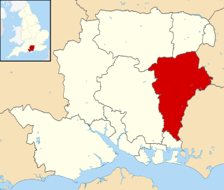
East Hampshire is a constituency represented in the House of Commons of the UK Parliament since 2010 by Damian Hinds of the Conservative Party.

<span class="mw-page-title-main">Grayshott</span> Human settlement in England

Grayshott is a village and civil parish in the East Hampshire district of Hampshire, England. It is on the Hampshire / Surrey border 4 miles (6.4 km) northwest of Haslemere by road, and 46 miles (74 km) southwest of central London. The nearest rail link is Haslemere railway station.

Sleaford in Hampshire, England is a hamlet of Headley Civil Parish and the Northanger Ecclesiastical Benefice. It is in the civil parish of Whitehill

Bramshott Military Camp, often simplified to Camp Bramshott, was a temporary army camp set up on Bramshott Common, Hampshire, England during both the First and Second World Wars.

<span class="mw-page-title-main">Bramshott</span> Human settlement in England

Bramshott is a village and parish with mediaeval origins in the East Hampshire district of Hampshire, England. It lies 0.9 miles (1.4 km) north of Liphook, and with Liphook forms the civil parish of Bramshott and Liphook.

Lindford is a village and civil parish in the East Hampshire district of Hampshire, England. It is approximately 1 mile (1.6 km) northeast of Bordon, and west of Headley, East Hampshire on the B3004 road.

<span class="mw-page-title-main">Ludshott Common and Waggoners Wells</span>

Ludshott Common and Waggoners Wells is a National Trust reserve; Ludshott Common is an area of heathland and Waggoners Wells a series of man-made ponds with a connecting stream. The reserve is situated between Grayshott, Bramshott and Headley Down in East Hampshire, England. To the south is the large heathland area of Bramshott Common. Some 415 acres (168 ha) is under the care of the Woodland Trust.

<span class="mw-page-title-main">Oakhanger, Hampshire</span> Human settlement in England

Oakhanger is a village in the East Hampshire district of Hampshire, England. Its nearest town is Bordon, which lies 1.7 miles (2.7 km) east, of the B3004 road. The village is part of the parish of Selborne, which covers an area of 7,915 acres (3,203 ha). The nearest railway station is Alton, which is 3.8 miles (6.1 km) northwest of the village, although Oakhanger formerly had its own military railway station, Oakhanger Halt railway station on the Longmoor Military Railway, until its closure.

<span class="mw-page-title-main">River Wey</span> River in southern England

The River Wey is a main tributary of the River Thames in south east England. Its two branches, one of which rises near Alton in Hampshire and the other in West Sussex to the south of Haslemere, join at Tilford in Surrey. Once combined, the flow is eastwards then northwards via Godalming and Guildford to meet the Thames at Weybridge. Downstream the river forms the backdrop to Newark Priory and Brooklands. The Wey and Godalming Navigations were built in the 17th and 18th centuries, to create a navigable route from Godalming to the Thames.

Whitehill is a village and civil parish in the East Hampshire district of Hampshire, England, on the historic highway between Petersfield and Farnham. It is 0.7 miles (1.1 km) south of Bordon and covers an area of approximately 8 square miles.

Barford is a scattered hamlet in the civil parish of Headley in the East Hampshire district of Hampshire, England. The village lies on the Hampshire-Surrey border, approximately 2 miles (3.2 km) from Hindhead. Its nearest town is Bordon, which lies approximately 3.6 miles (5.8 km) south-west from the village.

<span class="mw-page-title-main">Beacon Hill (Hindhead, Surrey)</span> Village in Surrey, England

Beacon Hill, while ecumenically and administratively part of Hindhead, Surrey, is a discrete settlement with its own history, amenities and character. It lies in the southwest corner of Surrey on the A287 road between the towns of Haslemere and Farnham. The village began to be developed in the 19th century.

Farnham and Bordon is a proposed constituency of the House of Commons in the UK Parliament. Further to the completion of the 2023 Periodic Review of Westminster constituencies, it will first be contested at the next general election. This cross-county constituency will cover parts of both Hampshire and Surrey.

References

  1. "Open Domesday: Neatham Hundred" . Retrieved 18 August 2023.
  2. Smith, John Owen (2003). Headley's past in pictures. J.O. Smith. ISBN   1873855273.
  3. William Page, ed. (1908). A History of the County of Hampshire. Vol. 3. London. pp. 51–55.{{cite book}}: CS1 maint: location missing publisher (link)
  4. "Hantsphere heritage in place" . Retrieved 30 June 2020.
  5. 1 2 British History Online: A History of the County of Hampshire. Vol. 3. London: Victoria County History. 1908. pp. 51–55. Retrieved 16 October 2022.
  6. "Old Maps of Headley Down (reference HOSM48074) - Francis Frith" . Retrieved 13 October 2013.
  7. Ordnance Survey
  8. "Headley's past in pictures (Hantsphere heritage in place)" . Retrieved 25 November 2015.
  9. Kelly's Directory of Hampshire, 1895.
  10. "Hantsphere heritage in place" . Retrieved 25 November 2015.
  11. Smith, John Owen. "A Glossary for Headley" . Retrieved 2 October 2013.
  12. "National Archives: Military Prisons" . Retrieved 3 March 2014.
  13. Dyson, Stephen (14 September 1993). Tank Twins. Pen & Sword Books. ISBN   0850522749.
  14. "All Tanked Up: Headley Village in the War" . Retrieved 7 October 2016.
  15. "Exploring Headley" . Retrieved 6 October 2013.
  16. "Whittle's closes". Bordon Herald. 9 October 2015. Retrieved 25 November 2015.
  17. "Headley Village Pump" . Retrieved 24 February 2014.
  18. "Headley Parish Plan - Social inclusion (2007)" . Retrieved 6 October 2013.
  19. "Bing Maps" . Retrieved 25 June 2019.
  20. "Stagecoach: 23 Bus Route & Timetable: Alton - Haslemere" . Retrieved 25 June 2019.
  21. John Owen Smith. "A Timeline for Headley" . Retrieved 24 June 2019.
  22. "Ofsted, 2012: The Holme C of E Controlled Primary School" . Retrieved 24 February 2014.
  23. "St. Francis Church" . Retrieved 24 February 2014.
  24. "Genuki: St Francis Community Church" . Retrieved 14 October 2022.
  25. "Charity Commission: Headley Scouts" . Retrieved 17 February 2024.
  26. "Headley Scouts" . Retrieved 17 February 2024.
  27. "Charity Commission: HDCA" . Retrieved 17 February 2024.
  28. "Petersfield Shine Radio: Haslemere Sun Club celebrates 75 sunny years" . Retrieved 17 February 2024.
  29. "Green burial park officially opens". Bordon Herald. 11 June 2015. Retrieved 26 October 2020.
  30. "National Trust | South East | Ludshott Common & Waggoner's Wells". Archived from the original on 17 September 2009.
  31. "Fuller's Vale Wildlife Pond Association" . Retrieved 2 October 2013.
  32. "Headley Public Utility Society" . Retrieved 26 November 2017.
  33. "'Celebrities' associated with Headley" . Retrieved 17 February 2024.
  34. "Anthony Powell Society Newsletter No.21, page 54" (PDF). Retrieved 16 August 2020.
  35. "An absent friend". Daily Telegraph Online. 27 November 2009. Retrieved 2 October 2013.
  36. "London Gazette: Sheriffs appointed for 1962" (PDF). London Gazette. 1962. p. 2144.

Further reading