Helena, Georgia

Last updated

Helena, Georgia
Helena Water Tower.JPG
Helena Water Tower
Telfair County Georgia Incorporated and Unincorporated areas Helena Highlighted.svg
Location in Telfair County and the state of Georgia
Coordinates: 32°4′29″N82°54′46″W / 32.07472°N 82.91278°W / 32.07472; -82.91278
Country United States
State Georgia
Counties Telfair, Wheeler
Area
  Total2.1 sq mi (5.5 km2)
  Land2.1 sq mi (5.5 km2)
  Water0 sq mi (0 km2)
Elevation
240 ft (73 m)
Population
 (2010)
  Total2,883
  Density1,098.6/sq mi (419.5/km2)
Time zone UTC-5 (Eastern (EST))
  Summer (DST) UTC-4 (EDT)
ZIP code
31037
Area code 229
FIPS code 13-37816 [1]
GNIS feature ID0315302 [2]

Helena was a city in Telfair and Wheeler counties in the U.S. state of Georgia. The population was 2,883 at the 2010 census, up from 2,307 in 2000 and 1,256 in 1990. The population increase accompanied establishment of the McRae Correctional Institution, which provided new jobs. The prison population is counted as well. On January 1, 2015, Helena and the adjacent city (and Telfair County seat) of McRae merged to form McRae-Helena.

Contents

History

The Georgia General Assembly incorporated the place as the Town of Helena in 1890. [3] It is unknown why the name "Helena" was applied to this community. [4]

By 2013, Helena's wastewater capacity had become too large for the city to manage. Simply turning over water services to neighboring McRae would have left Helena with only two services. Eventually, the two cities agreed to merge. The necessary legislation was signed into law on April 10, 2014. At midnight on January 1, 2015, Helena and McRae merged as the city of McRae-Helena. [5] [6]

Geography

Helena is located at 32°4′29″N82°54′46″W / 32.07472°N 82.91278°W / 32.07472; -82.91278 (32.074601, -82.912698). [7]

According to the United States Census Bureau, the city has a total area of 2.1 square miles (5.4 km2), all land.

Demographics

Historical population
CensusPop.Note
1900 604
1910 89047.4%
1920 9284.3%
1930 9633.8%
1940 1,07311.4%
1950 1,027−4.3%
1960 1,29025.6%
1970 1,230−4.7%
1980 1,39013.0%
1990 1,256−9.6%
2000 2,30783.7%
2010 2,88325.0%
2018 (est.)2,893 [8] 0.3%
U.S. Decennial Census [9]

As of the census [1] of 2000, there were 2,307 people, 520 households, and 322 families residing in the city. The population density was 1,092.3 inhabitants per square mile (421.7/km2). There were 603 housing units at an average density of 285.5 per square mile (110.2/km2). The racial makeup of the city was 42.35% White, 54.18% African American, 0.39% Asian, 2.43% from other races, and 0.65% from two or more races. Hispanic or Latino of any race were 3.42% of the population.

There were 520 households, out of which 30.6% had children under the age of 18 living with them, 37.1% were married couples living together, 20.2% had a female householder with no husband present, and 37.9% were non-families. 34.2% of all households were made up of individuals, and 15.4% had someone living alone who was 65 years of age or older. The average household size was 2.38 and the average family size was 3.04.

In the city, the population was spread out, with 14.2% under the age of 18, 15.3% from 18 to 24, 44.5% from 25 to 44, 18.7% from 45 to 64, and 7.3% who were 65 years of age or older. The median age was 33 years. For every 100 females, there were 235.3 males. For every 100 females age 18 and over, there were 281.5 males.

The median income for a household in the city was $22,212, and the median income for a family was $25,543. Males had a median income of $26,772 versus $18,208 for females. The per capita income for the city was $9,520. About 25.3% of families and 29.8% of the population were below the poverty line, including 46.0% of those under age 18 and 18.8% of those age 65 or over.

Related Research Articles

<span class="mw-page-title-main">Indian Springs Village, Alabama</span> Rural Area in Alabama, United States

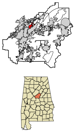
Indian Springs Village is a rural town in Shelby County, Alabama, United States, in the Birmingham metropolitan area. It incorporated effective November 14, 1990. At the 2010 census the population was 2,363, up from 2,225 in 2000.

Kaibab is an unincorporated community and census-designated place (CDP) in Mohave County, Arizona, United States. It is within the Kaibab Indian Reservation. The population of the CDP was 140 at the 2020 census.

<span class="mw-page-title-main">McRae, Arkansas</span> City in Arkansas, United States

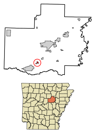
McRae is a city in White County, Arkansas, United States. The population was 682 at the 2010 census, estimated by 2018 to have decreased to 663 residents.

<span class="mw-page-title-main">Jupiter Inlet Colony, Florida</span> Town in the state of Florida, United States

Jupiter Inlet Colony is a town in Palm Beach County, Florida, United States. The town was incorporated in 1959 and is part of the Miami metropolitan area of South Florida. The population was 405 at the 2020 US census.

<span class="mw-page-title-main">Nicholls, Georgia</span> City in Georgia, United States

Nicholls is a city in Coffee County, Georgia, United States. The population was 2,798 as of the 2010 census, up from 1,008 in 2000, due to counting of the Coffee County Correctional Facility population within the city limits. This facility is privately owned and operated by CoreCivic.

<span class="mw-page-title-main">Edge Hill, Georgia</span> City in Georgia, United States

Edge Hill is a city in Glascock County, Georgia, United States. The population was 24 at the 2010 census. It is the smallest incorporated city in Georgia by population and ties for the smallest incorporated city in Georgia by area.

<span class="mw-page-title-main">Pendergrass, Georgia</span> City in Georgia, United States

Pendergrass is a city in Jackson County, Georgia, United States. The population was 1692 at the time of the 2020 census.

<span class="mw-page-title-main">Offerman, Georgia</span> City in Georgia, United States

Offerman is a city in Pierce County, Georgia, United States. The population was 441 at the 2010 census. It is part of the Waycross Micropolitan Statistical Area.

<span class="mw-page-title-main">McRae, Georgia</span> City in Georgia, United States

McRae was a city in and the county seat of Telfair County, Georgia, United States. It was designated as the seat in 1871, after being established the previous year as a station on the Macon and Brunswick Railroad. Upon the city's merger with adjacent Helena in 2015, the new county seat is the combined city of McRae-Helena.

<span class="mw-page-title-main">Yatesville, Georgia</span> Town in Georgia, United States

Yatesville is a town in Upson County, Georgia, United States. The population was 408 at the 2000 census.

<span class="mw-page-title-main">Varnell, Georgia</span> City in Georgia, United States

Varnell is a city in Whitfield County, Georgia, United States. It is part of the Dalton, Georgia Metropolitan Statistical Area. The population was 2,179 at the 2020 census.

<span class="mw-page-title-main">Horseshoe Bend, Idaho</span> City in Idaho, United States

Horseshoe Bend is the largest city in rural Boise County, in the southwestern part of the U.S. state of Idaho. Its population of 707 at the 2010 census was the largest in the county, though down from 770 in 2000.

<span class="mw-page-title-main">Ursa, Illinois</span> Village in Illinois, United States

Ursa is a village in Adams County, Illinois, United States. The population was 609 at the 2020 census. It is part of the Quincy, IL–MO Micropolitan Statistical Area.

<span class="mw-page-title-main">Sand Beach Township, Michigan</span> Civil township in Michigan, United States

Sand Beach Township is a civil township of Huron County in the U.S. state of Michigan. The population was 1,470 at the 2000 census.

<span class="mw-page-title-main">Hudson, Michigan</span> City in Michigan, United States

Hudson is a city in Lenawee County in the U.S. state of Michigan. The population was 2,415 at the 2020 census. The city is mostly surrounded by Hudson Township, but the two are administered autonomously.

<span class="mw-page-title-main">New Lebanon, Pennsylvania</span> Borough in Pennsylvania, United States

New Lebanon is a borough in northeastern Mercer County, Pennsylvania, United States. The population was 186 at the 2020 census. It is part of the Hermitage micropolitan area.

<span class="mw-page-title-main">Golinda, Texas</span> City in Texas, United States

Golinda is a city in Falls and McLennan counties in the U.S. state of Texas. The population was 618 at the 2020 census, an increase over the figure of 559 tabulated in 2010.

<span class="mw-page-title-main">Kaibab Indian Reservation</span> Indian Reservation

The Kaibab Indian Reservation is the home of the Kaibab Band of Paiute Indians, a federally recognized tribe of Southern Paiutes. The Indian reservation is located in northern part of the U.S. state of Arizona. It covers a land area of 188.75 square miles (488.9 km2) in northeastern Mohave County and northwestern Coconino County adjacent to the southern Utah border. The Pipe Spring National Monument lies in the southwestern section of the reservation. The Thunder Mountain Pootseev Dark-sky preserve is colocated with the reservation.

<span class="mw-page-title-main">Brunswick (CDP), Maine</span> Census-designated place in Maine, United States

Brunswick is a census-designated place (CDP) in the town of Brunswick in Cumberland County, Maine, United States. The population was 15,175 at the 2010 census. It is part of the Portland–South Portland–Biddeford, Maine Metropolitan Statistical Area.

<span class="mw-page-title-main">McRae–Helena, Georgia</span> City in Georgia, United States

McRae–Helena is a city in the U.S. state of Georgia, formed on January 1, 2015, by the merger of the two cities of McRae and Helena. McRae–Helena is the county seat of Telfair County.

References

  1. 1 2 "U.S. Census website". United States Census Bureau . Retrieved January 31, 2008.
  2. "US Board on Geographic Names". United States Geological Survey. October 25, 2007. Retrieved January 31, 2008.
  3. Acts and Resolutions of the General Assembly of the State of Georgia. Clark & Hines, State Printers. 1906. p. 809.
  4. Krakow, Kenneth K. (1975). Georgia Place-Names: Their History and Origins (PDF). Macon, GA: Winship Press. p. 107. ISBN   0-915430-00-2.
  5. McLean, Liz (April 10, 2015). "Once Divided, Now United, McRae-Helena Focused on Future, Downtown". Georgia Municipal Association. Archived from the original on December 1, 2015. Retrieved February 19, 2017.
  6. "2013-2014 Regular Session - HB 967 City of McRae-Helena; create and incorporate new municipality; provisions". Georgia General Assembly. Retrieved February 19, 2017.
  7. "US Gazetteer files: 2010, 2000, and 1990". United States Census Bureau. February 12, 2011. Retrieved April 23, 2011.
  8. "Population and Housing Unit Estimates" . Retrieved December 2, 2019.
  9. "Census of Population and Housing". Census.gov. Retrieved June 4, 2015.