
Underground hard-rock mining refers to various underground mining techniques used to excavate "hard" minerals, usually those containing metals, such as ore containing gold, silver, iron, copper, zinc, nickel, tin, and lead. It also involves the same techniques used to excavate ores of gems, such as diamonds and rubies. Soft-rock mining refers to the excavation of softer minerals, such as salt, coal, and oil sands.

Molybdenite is a mineral of molybdenum disulfide, MoS2. Similar in appearance and feel to graphite, molybdenite has a lubricating effect that is a consequence of its layered structure. The atomic structure consists of a sheet of molybdenum atoms sandwiched between sheets of sulfur atoms. The Mo-S bonds are strong, but the interaction between the sulfur atoms at the top and bottom of separate sandwich-like tri-layers is weak, resulting in easy slippage as well as cleavage planes. Molybdenite crystallizes in the hexagonal crystal system as the common polytype 2H and also in the trigonal system as the 3R polytype.

Chuquicamata is the largest open pit copper mine by excavated volume in the world. It is located in the north of Chile, just outside Calama at 2,850 m (9,350 ft) above sea level, 215 km (134 mi) northeast of Antofagasta and 1,240 km (770 mi) north of the capital, Santiago. Flotation and smelting facilities were installed in 1952, and expansion of the refining facilities in 1968 made 500,000 ton annual copper production possible in the late 1970s. Previously part of Anaconda Copper, the mine is now owned and operated by Codelco, a Chilean state enterprise, since the Chilean nationalization of copper in the late 1960s and early 1970s. Its depth of 850 metres (2,790 ft) makes it the second deepest open-pit mine in the world after Bingham Canyon Mine in Utah, United States.

Codelco is a Chilean state owned copper mining company. It was formed in 1976 from foreign-owned copper companies that were nationalised in 1971.

Porphyry copper deposits are copper ore bodies that are formed from hydrothermal fluids that originate from a voluminous magma chamber several kilometers below the deposit itself. Predating or associated with those fluids are vertical dikes of porphyritic intrusive rocks from which this deposit type derives its name. In later stages, circulating meteoric fluids may interact with the magmatic fluids. Successive envelopes of hydrothermal alteration typically enclose a core of disseminated ore minerals in often stockwork-forming hairline fractures and veins. Because of their large volume, porphyry orebodies can be economic from copper concentrations as low as 0.15% copper and can have economic amounts of by-products such as molybdenum, silver, and gold. In some mines, those metals are the main product.

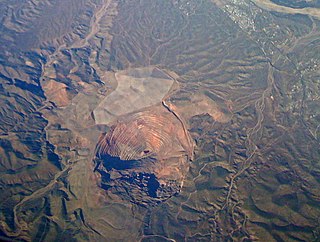
The Bingham Canyon Mine, more commonly known as Kennecott Copper Mine among locals, is an open-pit mining operation extracting a large porphyry copper deposit southwest of Salt Lake City, Utah, in the Oquirrh Mountains. The mine is the largest man-made excavation, and deepest open-pit mine in the world, which is considered to have produced more copper than any other mine in history – more than 19 million tons. The mine is owned by Rio Tinto Group, a British-Australian multinational corporation. The copper operations at Bingham Canyon Mine are managed through Kennecott Utah Copper Corporation which operates the mine, a concentrator plant, a smelter, and a refinery. The mine has been in production since 1906, and has resulted in the creation of a pit over 0.75 miles (1,210 m) deep, 2.5 miles (4 km) wide, and covering 1,900 acres. It was designated a National Historic Landmark in 1966 under the name Bingham Canyon Open Pit Copper Mine. The mine experienced a massive landslide in April 2013 and a smaller slide in September 2013.

A polymetallic replacement deposit, also known as carbonate replacement deposit or high-temperature carbonate-hosted Ag-Pb-Zn deposit, is an orebody of metallic minerals formed by the replacement of sedimentary, usually carbonate rock, by metal-bearing solutions in the vicinity of igneous intrusions. When the ore forms a blanketlike body along the bedding plane of the rock, it is commonly called a manto ore deposit. Other ore geometries are chimneys and veins. Polymetallic replacements/mantos are often stratiform wall-rock replacement orebodies distal to porphyry copper deposits, or porphyry molybdenum deposits. The term manto is from the Spanish word for mantle, or cloak, although the geologic manto is more like a mantle roll than a sheetlike structure.
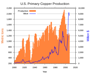
Copper mining in the United States has been a major industry since the rise of the northern Michigan copper district in the 1840s. In 2017 the United States produced 1.27 million metric tonnes of copper, worth $8 billion, making it the world's fourth largest copper producer, after Chile, China, and Peru. Copper was produced from 23 mines in the US. Top copper producing states in 2014 were Arizona, Utah, New Mexico, Nevada, and Montana. Minor production also came from Idaho, and Missouri. As of 2014, the US had 45 million tonnes of known remaining reserves of copper, the fifth largest known copper reserves in the world, after Chile, Australia, Peru, and Mexico.

Uranium mining in Colorado, United States, goes back to 1872, when pitchblende ore was taken from gold mines near Central City, Colorado. The Colorado uranium industry has seen booms and busts, but continues to this day. Not counting byproduct uranium from phosphate, Colorado is considered to have the third largest uranium reserves of any US state, behind Wyoming and New Mexico.

Silver mining in Colorado has taken place since the 1860s. In the past, Colorado called itself the Silver state.
The Safford Mine is an open-pit copper mine located in Graham County, Arizona, eight miles (13 km) north of the city of Safford. The mine is owned and operated by Freeport-McMoran Copper & Gold.

El Teniente is an underground copper mine located in the Chilean Andes, 2,300 m (7,500 ft) above mean sea level. It is in the commune of Machalí in Cachapoal Province, Libertador General Bernardo O'Higgins Region, near the company town of Sewell. This was established for the workers and their families.
The Climax mine, located in Climax, Colorado, United States, is a major molybdenum mine in Lake and Summit counties, Colorado. Shipments from the mine began in 1915. At its highest output, the Climax mine was the largest molybdenum mine in the world, and for many years it supplied three-fourths of the world's supply of molybdenum.

The Batu Hijau mine is an open pit copper-gold mine operated by PT. Amman Mineral Nusa Tenggara. The mine is the second largest copper-gold mine in Indonesia behind the Grasberg mine of PT. Freeport Indonesia. The mine is located 1,530 kilometres (950 mi) east of the Indonesian capital Jakarta on Sumbawa, in southern Taliwang regency, an island in West Nusa Tenggara. The mine is the result of a ten-year exploration and construction program based on a 1999 discovery of the porphyry copper deposit. Production began in 2000.

Cortez Gold Mine is a large gold mining and processing facility in Lander and Eureka County, Nevada, United States, located approximately 75 miles (120 km) southwest of Elko. It is owned as a joint venture between Barrick Gold Corporation (61.5%) and Newmont Corporation (38.5%), operated by Barrick, and comprises the Pipeline, Crossroads, and Cortez Hills open pit mines; and the Cortez Hills underground mine. Ore from the mines is treated at an oxide mill at the site and on leach pads, while refractory ore is shipped to Barrick’s Goldstrike operation for processing.
The San Manuel Copper Mine was a surface and underground porphyry copper mine located in San Manuel, Pinal County, Arizona. Frank Schultz was the original discoverer, in 1879, but the main body of the deposits were discovered by Henry W. Nichols in 1942. The exploration drilling went on from 1943 to 1948, with the first mine shaft built 1948. Louis Lesser developed a mining city to service Nichols’ newly discovered deposits, and the development was completed about 1954. The first major production began in 1955, and the mine and smelter were permanently closed in 2003.

Los Pelambres mine is a copper mine located in the north-central of Chile in Coquimbo Region. It is one of the largest copper reserves in the world, having estimated reserves of 4.9 billion tonnes of ore grading 0.65% copper.

The Cerro Verde mine is a very large copper mine located about 20 miles southwest of Arequipa, in southwestern Peru. Cerro Verde represents one of the largest copper reserves in Peru and in the world, having estimated reserves of 4.63 billion tonnes of ore grading 0.4% copper and 113.2 million oz of silver.
McNulty rhyolite is one of four intrusive, igneous geological formations, the Chalk Mountain nevadite, Lincoln porphyry, McNulty rhyolite and Quail porphyry, described, mapped, and named by S. F. Emmons in 1898 within the Tenmile Mining District of southern Summit County, Colorado. The McNulty rhyolite, which is also known as the McNulty Gulch rhyolite, is described by S. F. Emmons as a fine-grained porphyritic rhyolite that is light gray in color and contains many small white feldspars and locally some small smoky quartz crystals. He mapped it as being exposed as small irregular masses in McNulty Gulch and southward beyond the area of the Tenmile Mining District that was mapped at the time. One exposure above the Railroad Boy tunnel, his location 45 in McNulty Gulch, exhibited small drusy cavities containing little tablets of tridymite. He proposed that this rhyolite was either intruded contemporaneously withy or later than the Chalk Mountain nevadite at the time of eruption. Based on field mapping, the McNulty rhyolite was interpreted to cross-cut and post-date the Lincoln and the Quail porphyries. Later geologic mapping in the Tenmile Mining District eliminated the McNulty rhyolite as a recognized geologic formation.

Molybdenum mining in the United States produced 65,500 metric tons of molybdenum in 2014, worth US$1.8 billion. The US was the world's second-largest molybdenum producer, after China, and provided 25% of the world's supply of molybdenum.

