Castlewood is a neighborhood in the City of Centennial, Colorado. A former census-designated place (CDP), the population was 25,567 at the 2000 census. It has been a part of the City of Centennial since the city's incorporation in 2001.
Columbine is an unincorporated community and a census-designated place (CDP) located in and governed by Jefferson and Arapahoe counties, Colorado, United States. The CDP is a part of the Denver–Aurora–Lakewood, CO Metropolitan Statistical Area. Located primarily in Jefferson County, Columbine lies immediately south of Denver. The population of the Columbine CDP was 24,280 at the United States Census 2010. The community lies in ZIP code 80123.

Southglenn is a neighborhood in the City of Centennial, Colorado. A former census-designated place (CDP), the population was 43,520 at the 2000 census.

Acres Green is an unincorporated community and a census-designated place (CDP) located in and governed by Douglas County, Colorado, United States. The CDP is a part of the Denver–Aurora–Lakewood, CO Metropolitan Statistical Area. The population of the Acres Green CDP was 3,007 at the 2010 United States Census. The community lies in ZIP Code 80124.

Carriage Club is a neighborhood in the City of Lone Tree, Douglas County, Colorado, United States. A former census-designated place (CDP), the population was 1,002 at the United States Census 2000.

Cottonwood is a neighborhood in the Town of Parker, Colorado. A former census-designated place (CDP), the population was 931 at the 2000 census.
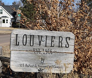
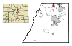
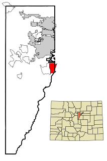
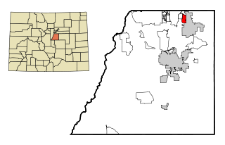
Louviers is an unincorporated town, a post office, and a census-designated place (CDP) located in and governed by Douglas County, Colorado, United States. The CDP is a part of the Denver–Aurora–Lakewood, CO Metropolitan Statistical Area. The Louviers post office has the ZIP Code 80131. At the United States Census 2010, the population of the Louviers CDP was 269, while the population of the 80131 ZIP Code Tabulation Area was 243.

Meridian is an unincorporated community and a census-designated place (CDP) located in and governed by Douglas County, Colorado, United States. The CDP is a part of the Denver–Aurora–Lakewood, CO Metropolitan Statistical Area. The population of the Meridian CDP was 2,970 at the United States Census 2010. The CDP lies in ZIP code 80112.

Sedalia is an unincorporated town, a post office, and a census-designated place (CDP) located in and governed by Douglas County, Colorado, United States. The CDP is a part of the Denver–Aurora–Lakewood, CO Metropolitan Statistical Area. The Sedalia post office has the ZIP Code 80135. At the United States Census 2010, the population of the Sedalia CDP was 206, while the population of the 80135 ZIP Code Tabulation Area was 3,833 including adjacent areas.
Stonegate is an unincorporated community and a census-designated place (CDP) located in and governed by Douglas County, Colorado, United States. The CDP is a part of the Denver–Aurora–Lakewood, CO Metropolitan Statistical Area. The population of the Stonegate CDP was 8,962 at the United States Census 2010. The Stonegate Village Metropolitan District provides services to the community, which lies in ZIP Code 80134.

The Pinery is an unincorporated community and a census-designated place (CDP) located in and governed by Douglas County, Colorado, United States. The CDP is a part of the Denver–Aurora–Lakewood, CO Metropolitan Statistical Area. The population of The Pinery CDP was 10,517 at the United States Census 2010. Douglas County governs the unincorporated community. The Parker post office serves the area.
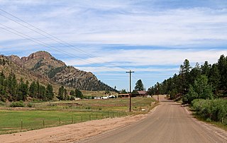
Westcreek is an unincorporated community and a census-designated place (CDP) located in and governed by Douglas County, Colorado, United States. The CDP is a part of the Denver–Aurora–Lakewood, CO Metropolitan Statistical Area. The population of the Westcreek CDP was 129 at the United States Census 2010. The Sedalia post office serves the area.

Grand View Estates is an unincorporated community and a census-designated place (CDP) located in and governed by Douglas County, Colorado, United States. The CDP is a part of the Denver–Aurora–Lakewood, CO Metropolitan Statistical Area. The population of the Grand View Estates CDP was 528 at the United States Census 2010. The area lies in ZIP code 80134..

Holly Hills is an unincorporated community and a census-designated place (CDP) located in and governed by Arapahoe County, Colorado, United States. Holly Hills is an enclave of the City and County of Denver. The CDP is a part of the Denver–Aurora–Lakewood, CO Metropolitan Statistical Area. The population of the Holly Hills CDP was 2,521 at the United States Census 2010. Denver post office 80222 serves the area.
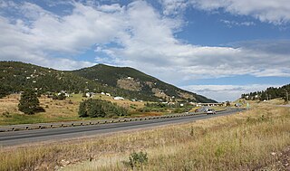
Floyd Hill is an unincorporated community and a census-designated place (CDP) located in and governed by Clear Creek County, Colorado, United States. The CDP is a part of the Denver–Aurora–Lakewood, CO Metropolitan Statistical Area. The population of the Floyd Hill CDP was 1,048 at the United States Census 2020. The Evergreen post office serves the area.

Sterling Ranch is an unincorporated community and a census-designated place (CDP) located in and governed by Douglas County, Colorado, United States. The CDP is a part of the Denver–Aurora–Lakewood, CO Metropolitan Statistical Area. Douglas County governs the unincorporated community and the Sterling Ranch Community Authority Board provides services through several metropolitan districts. The Littleton post office serves the area.
Echo Hills is an unincorporated community and a census-designated place (CDP) located in and governed by Clear Creek County, Colorado, United States. The CDP is a part of the Denver–Aurora–Lakewood, CO Metropolitan Statistical Area. The Evergreen post office serves the area.
Meridian Village is an unincorporated community and a census-designated place (CDP) located in and governed by Douglas County, Colorado, United States. The CDP is a part of the Denver–Aurora–Lakewood, CO Metropolitan Statistical Area. The Meridian Metropolitan District provides services to the area, which lies in ZIP code 80134.
Sierra Ridge is an unincorporated community and a census-designated place (CDP) located in and governed by Douglas County, Colorado, United States. The CDP is a part of the Denver–Aurora–Lakewood, CO Metropolitan Statistical Area. The unincorporated community lies in ZIP Code 80134.
Stepping Stone is an unincorporated community and a census-designated place (CDP) located in and governed by Douglas County, Colorado, United States. The CDP is a part of the Denver–Aurora–Lakewood, CO Metropolitan Statistical Area. The unincorporated community lies in ZIP code 80134.