Līmes is a modern term used primarily for the Germanic border defence or delimiting system of Ancient Rome marking the borders of the Roman Empire, but it was not used by the Romans for that purpose. The term has been extended to refer to the frontier defences in other parts of the empire, such as in the east and in Africa.
The Limes Germanicus is the name given in modern times to a line of frontier fortifications that bounded the ancient Roman provinces of Germania Inferior, Germania Superior and Raetia, dividing the Roman Empire and the unsubdued Germanic tribes from the years 83 to about 260 AD. The Limes used either a natural boundary such as a river or typically an earth bank and ditch with a wooden palisade and watchtowers at intervals. A system of linked forts was built behind the Limes.

The Befreiungshalle is a neoclassical monument on the Michelsberg hill above the town of Kelheim in Bavaria, Germany. It stands upstream of Regensburg on the river Danube at the confluence of the Danube and the Altmühl, i.e. the Rhine–Main–Danube Canal. It is just downstream of the Danube Gorge, towering above its lower end. It was commissioned by King Ludwig I of Bavaria to commemorate the victory over Napoleon in the Befreiungskriege of 1813–1815.
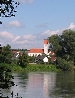
Neustadt an der Donau is a town in Lower Bavaria on the Danube in Bavaria, Germany. Lying on the western border of Landkreis Kelheim, Neustadt is primarily known for the thermal spa Bad Gögging. Neustadt had a population of 12,753 as of December 31, 2003.
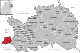
Lorch is a small town in the Ostalbkreis district, in Baden-Württemberg, Germany, by the river Rems, 8 kilometers west of Schwäbisch Gmünd. It is a part of the Ostwürttemberg region.

Taunusstein is the biggest town in the Rheingau-Taunus-Kreis in the Regierungsbezirk of Darmstadt in Hessen, Germany. It has 30,068 inhabitants (2020).

Illerkirchberg is a town in the district of Alb-Donau in Baden-Württemberg in Germany.

Roman military borders and fortifications were part of a grand strategy of territorial defense in the Roman Empire, although this is a matter of debate. By the early 2nd century, the Roman Empire had reached the peak of its territorial expansion and rather than constantly expanding their borders as earlier in the Empire and Republic, the Romans solidified their position by fortifying their strategic position with a series of fortifications and established lines of defense. Historian Adrian Goldsworthy argues that the Romans had reached the natural limits which their military traditions afforded them conquest over and that beyond the borders of the early-to-mid Empire lay peoples whose military traditions made them militarily unconquerable, despite many Roman battle victories. In particular, Goldsworthy argues that the cavalry-based warfare of the Parthians, Sarmatians and Persians presented a major challenge to the expansion of Rome's infantry-based armies.

Saal is a municipality in the district of Kelheim in Bavaria in Germany. It is located along the banks of the Danube River, around 25 km southwest of Regensburg.

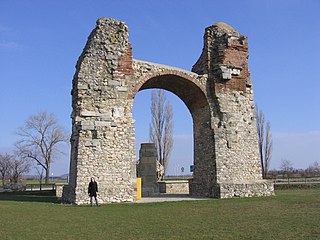
Rheinbrohl is a municipality in the territorial collectivity of Bad Hönningen, in the district of Neuwied, in Rhineland-Palatinate, in western Germany. On its Rhine bank is the starting point of the Upper Germanic-Rhaetian Limes, the fortification of 550 km length which delimited the Roman Empire. At this place near the Rhine is the reconstruction of a Roman watchtower.
EuroVelo 6 (EV6), named the "Rivers Route", is a EuroVelo long-distance cycling route that runs along 3,653 km (2,270 mi) some of Europe's major rivers, including much of the Loire, some of the Saône, a short section of the upper Rhine and almost the entire length of Europe’s second longest river, the Danube — from the Atlantic coast of France to the city of Constanța on the Black Sea.

The Upper Germanic-Rhaetian Limes, or ORL, is a 550-kilometre-long section of the former external frontier of the Roman Empire between the rivers Rhine and Danube. It runs from Rheinbrohl to Eining on the Danube. The Upper Germanic-Rhaetian Limes is an archaeological site and, since 2005, a UNESCO World Heritage Site. Together with the Lower Germanic Limes it forms part of the Limes Germanicus.

The Lower Germanic Limes is the former frontier between the Roman province of Germania Inferior and Germania Magna. The Lower Germanic Limes separated that part of the Rhineland left of the Rhine as well as the Netherlands, which was part of the Roman Empire, from the less tightly controlled regions east of the Rhine.
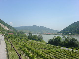
The Danubian Limes, or Danube Limes, refers to the Roman military frontier or limes which lies along the River Danube in the present-day German state of Bavaria, in Austria, Slovakia, Hungary, Croatia, Serbia, Bulgaria and Romania.

The Neckar-Odenwald Limes is a collective term for two, very different early sections of the Upper Germanic-Rhaetian Limes, a Roman defensive frontier line that may have been utilised during slightly different periods in history. The Neckar-Odenwald Limes consists of the northern Odenwald Limes (Odenwaldlimes), a cross-country limes with camps, watchtowers and palisades, which linked the River Main with the Neckar, and the adjoining southern Neckar Limes (Neckarlimes), which in earlier research was seen as a typical 'riverine limes', whereby the river replaced the function of the palisade as an approach obstacle. More recent research has thrown a different light on this way of viewing things that means may have to be relativized in future. The resulting research is ongoing.
The Alb Limes is a Roman frontier fortification or limes of the late 1st century AD in the Swabian Jura, also known as the Swabian Alb. The Alb Limes runs for just under 135 kilometres from Rottweil in the southwest to Heidenheim an der Brenz in the northeast.
The Pannonian Limes is part of the old Roman fortified frontier known as the Danubian Limes that runs for approximately 420 km (260 mi) from the Roman camp of Klosterneuburg in the Vienna Basin in Austria to the castrum in Singidunum (Belgrade) in present-day Serbia. The garrisons of these camps protected the Pannonian provinces against attacks from the north from the time of Augustus (31 BC–14 AD) to the beginning of the 5th century. In places this section of the Roman limes also crossed the river into the territory of the barbarians (Barbaricum).
The Danube–Iller–Rhine Limes or DIRL was a large-scale defensive system of the Roman Empire that was built after the project for the Upper Germanic-Rhaetian Limes in the late 3rd century AD. In a narrower sense the term refers only to the fortifications between Lake Constance and the River Danube (Danubius); in a broader sense it also includes the other Late Roman fortifications along the river Rhine (Rhenus) on the High Rhine and on the Upper Rhine as well as the Upper Danube.

Kastell Zugmantel is a former Roman garrison site designed for a complement the size of a cohort. The facility is located on the western Taunus section of the Upper Germanic-Rhaetian Limes, and has been a UNESCO World Heritage Site since 2005. The above-ground remains in the area, still very visible, are located in a forest edge area of Taunusstein-Orlen in the Hessian Rheingau-Taunus-Kreis.

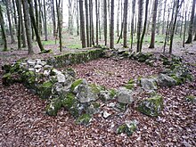
The castellum or small fort nowadays called Am Forsthofweg was a Roman military camp of the Upper Germanic-Rhaetian Limes. It received UNESCO World Heritage status in 2005.