
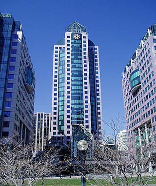
Bay Street is a major thoroughfare in Downtown Toronto, Ontario, Canada. It is the centre of Toronto's Financial District and is often used by metonymy to refer to Canada's financial services industry since succeeding Montreal's St. James Street in that role in the 1970s.
The Municipality of Metropolitan Toronto was an upper-tier level of municipal government in Ontario, Canada, from 1953 to 1998. It was made up of the old city of Toronto and numerous townships, towns and villages that surrounded Toronto, which were starting to urbanize rapidly after World War II. It was commonly referred to as "Metro Toronto" or "Metro".

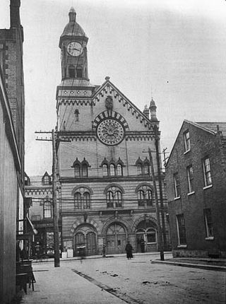
The Great Fire of Toronto of 1904 destroyed a large section of Downtown Toronto, Ontario, Canada on April 19, 1904. It was the second such fire for the city in its history.
Mount Sinai Hospital (MSH) is a hospital in Toronto, Ontario, Canada. Mount Sinai is part of Sinai Health. Sinai Health was formed through the voluntary amalgamation of Mount Sinai Hospital and Hennick Bridgepoint Hospital on January 22, 2015.

Lawrence Heights is a neighbourhood in Toronto, Ontario, Canada. It is located north-west of central Toronto, in the district of North York. The neighbourhood is roughly bounded by Lawrence Avenue to the south, Yorkdale Road to the north, Varna Drive to the east and Dufferin Street to the west. It is part of the greater Yorkdale-Glen Park official Toronto neighbourhood.

Henry Farm is a neighbourhood in the City of Toronto, Ontario, Canada. It is located in the north central part of the city within the former city of North York.

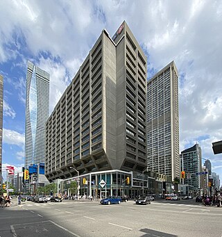
St. George is a station on Line 1 Yonge–University and Line 2 Bloor–Danforth of the Toronto subway. It is located north of Bloor Street West between St. George Street and Bedford Road. It is the second-busiest station in the system after Bloor–Yonge station, serving a combined total of approximately 260,647 people a day. Wi-Fi service is available at this station.

Greektown, also known as The Danforth, is a commercial-residential neighbourhood and ethnic enclave in Toronto, Ontario, Canada. It is located on Danforth Avenue, between Chester Avenue and Dewhurst Boulevard, in east Toronto. Named after Asa Danforth, Jr., an American contractor who designed Queen Street and Kingston Road, the area is known for its architecture dating back to as early as 1910, and for its number of Greek restaurants and stores. The area was one of the major settlement areas of Greek immigrants to Toronto after World War I.
Yorkville Town Hall was the municipal building for the Village of Yorkville before its annexation by the City of Toronto. Built in 1859-1860 by architect William Hay and his apprentice Henry Langley, the three-storey building also served as an omnibus stop. The hall was located north of Bloor Street on Yonge Street, along the west side.

Sir Adam Beck Hydroelectric Generating Stations are two hydroelectric generating stations in Niagara Falls, Ontario, Canada. Sir Adam Beck Generating Station I, Sir Adam Beck Generating Station II and the Sir Adam Beck Pump Generating Station are all owned by Ontario Power Generation. Following the development of several smaller generating stations around Niagara Falls in the late 19th and early 20th centuries, the Province of Ontario authorized the construction of the first major publicly owned generating station in the province. At the time it was built, it was the largest hydroelectric generating station in the world.

Downtown Toronto is the main central business district of Toronto, Ontario, Canada. Located entirely within the district of Old Toronto, it is approximately 16.6 square kilometres in area, bounded by Bloor Street to the northeast and Dupont Street to the northwest, Lake Ontario to the south, the Don Valley to the east, and Bathurst Street to the west. It is also the home of the municipal government of Toronto and the Government of Ontario.

Islington-City Centre West is a commercial and residential neighbourhood in Toronto, Ontario, Canada. One of four central business districts outside Downtown Toronto, it is bounded by Rathburn Road to the north, Islington Avenue to the east, Bloor Street to the south, Mimico Creek to the west.

Humbermede, often called Emery, is a neighbourhood of Toronto, Ontario, Canada. Humbermede, like many of the "Humber" neighbourhoods in the city, gets its name from the Humber River. It is bounded on the west by the Humber River, on the north by Finch Avenue West, on the east by the Highway 400 and on the south by Sheppard Avenue West.

Lansing is a neighbourhood in Toronto, Ontario, Canada. It originated as a minor settlement of a store, other services and a post office at the corner of Yonge Street and Sheppard Avenue and later got consolidated with Toronto as sprawling development took place. A larger area was designated as the postal village of Lansing. The City of Toronto labels it as Lansing-Westgate for neighbourhood planning purposes with the boundaries Yonge Street to the east, Highway 401 to the south, Bathurst Street to the west and Burnett Avenue to the north.

Don Valley Village is a neighbourhood in the city of Toronto, Ontario, Canada. It is located in the former suburb of North York. Located north of Highway 401 and bisected by Don Mills Road, it is bounded by Sheppard Avenue to the south, Leslie Street to the west, Finch Avenue to the north and Highway 404 to the east. Like the nearby Don River Valley, the neighbourhood has hill and dale topography.

The Fleet Street Pumping Station is a historic water pumping station in Ottawa, Ontario, Canada. It is west of downtown in the LeBreton Flats area, near the new Canadian War Museum.

The Ashbridges Bay Wastewater Treatment Plant is the city of Toronto's main sewage treatment facility, and the second largest such plant in Canada after Montreal's Jean-R. Marcotte facility. One of four plants that service the city of Toronto, it treats the wastewater produced by some 1.4 million of the city's residents and has a rated capacity of 818,000 cubic metres per day. Until 1999 it was officially known as the Main Treatment Plant. The plant has a 185 m (607 ft) high smokestack which is visible from most parts of the city.

South Hill is a neighbourhood in Toronto, Ontario, Canada. It is located north of downtown and covers the area west of Avenue Road, south of St. Clair Avenue, east of Spadina Road, and north of the Canadian Pacific railway tracks. The area is dominated by the steep hill of the Niagara escarpment. The Nordheimer Ravine also cuts through the area, which is surrounded by Sir Winston Churchill Park. This park covers the northwestern portion of South Hill.
Mink Mile is an upscale shopping district in the neighbourhood of Yorkville in Toronto, Ontario, Canada, along Bloor Street between Yonge Street and Avenue Road.
Armour Heights is a neighbourhood in Toronto, Ontario, Canada, in the district of North York. It is bounded by Wilson Avenue to the south, Bathurst Street to the west, and the west branch of the Don River to the north and east. Highway 401 cuts through the centre of the neighbourhood.
