Yorkville, Toronto

Last updated

Yorkville
Neighbourhood
Yorkville Toronto 2022.jpg
Village of Yorkville Park and Cumberland Street in 2022
Yorkville Village Coat of Arms.jpg
Yorkville map.PNG
Historically Yorkville was the area north of Bloor and east of Avenue Rd., today a number of other areas are also considered part of the district
Toronto map.svg
Red pog.svg
Location within Toronto
Coordinates: 43°40′13″N79°23′28″W / 43.67028°N 79.39111°W / 43.67028; -79.39111
CountryFlag of Canada (Pantone).svg  Canada
ProvinceFlag of Ontario.svg  Ontario
City Toronto
Established1830 (1830)
Incorporated1853 (as village)
Annexed1883 (by City of Toronto)
Government
   MP Chrystia Freeland
   MPP Jessica Bell
   Councillor Dianne Saxe (Ward 11 University-Rosedale)
Area
  Total0.329 km2 (0.127 sq mi)
Population
 (2021) [2]
  Total5,349
  Density16,258/km2 (42,110/sq mi)
Time zone UTC-5 (Eastern Time Zone)
  Summer (DST) UTC-4 (Eastern Time Zone)
Area code(s) 416, 647

Yorkville is a neighbourhood and former village in Toronto, Ontario, Canada. It is roughly bounded by Bloor Street to the south, Davenport Road to the north, Yonge Street to the east and Avenue Road to the west, and it is part of The Annex neighbourhood. Established as a separate community in 1830, it was annexed into Toronto in 1883. Yorkville comprises residential areas, office space, and retail shopping.

Contents

The Mink Mile shopping district on Bloor Street is located in Yorkville.

History

Yorkville was funded in 1830 by the entrepreneur Joseph Bloore (after whom Bloor Street, one of Toronto's main thoroughfares, is named) and William Botsford Jarvis of Rosedale and began as a residential suburb. Bloore operated a brewery north-east of today's Bloor and Church Street intersection, and Jarvis was Sheriff of the Home District. The two purchased land in the Yorkville area and subdivided it into smaller lots on new side streets for those interested in living in the cleaner air outside York.

The political centre of Yorkville was the Red Lion Hotel, an inn that was regularly used as the polling place for elections. It is there that William Lyon Mackenzie was voted back into the Legislature for 1832, and a huge procession took him down Yonge Street. [3]

The community grew enough to be connected in 1849 by an omnibus service to Toronto. By 1853, the population of Yorkville had reached 1,000, the figure needed to incorporate as a village, and the "Village of Yorkville" was incorporated. Development increased and by the 1870s, "Potter's Field," a cemetery stretching east of Yonge Street along the north side of Concession Road (today's Bloor Street) was closed, and the remains moved to the Toronto Necropolis and Mount Pleasant Cemetery. [4]

John Daniels' House, 1867 John Daniels' House Yorkville.jpg
John Daniels' House, 1867
Stores in Yorkville, circa 1975 Row of shops at Yonge and Yorkville circa 1975 Toronto.jpg
Stores in Yorkville, circa 1975

By the 1880s, the cost of delivering services to the large population of Yorkville was beyond the Village's ability. It petitioned the Toronto government to be annexed. Annexation came on February 1, 1883, and Yorkville's name changed officially from the "Village of Yorkville" to "St. Paul's Ward," [4] and the former "Yorkville Town Hall" became "St. Paul's Hall."

The character of the suburb did not change and its Victorian-style homes, residential streets, and gardens survived into the 20th century.[ citation needed ] In 1923, Toronto Hebrew Maternity and Convalescent Hospital was opened at 100 Yorkville Avenue, and a year later, its name was changed to Mount Sinai Hospital. The facade of the building still stands today and housed the retailer Chanel.

In the 1960s, Yorkville flourished as Toronto's bohemian cultural centre. It was the breeding ground for some of Canada's most noted musical talents, including Joni Mitchell, Neil Young, and Gordon Lightfoot, as well as then-underground literary figures such as Margaret Atwood, Gwendolyn MacEwen, and Dennis Lee. [5] Yorkville was also known as the Canadian center of the hippie movement. In 1968, the nearby Rochdale College at the University of Toronto was opened on Bloor Street as an experiment in counterculture education. Those influenced by their time in 1960s-1970s Yorkville include the cyberpunk writer William Gibson. Its domination by hippies and young people led MPP Syl Apps to refer to it as "a festering sore in the middle of the city" and call for its "eradication." [6] Joni Mitchell captured a colorful impression of the nightlife scene on Yorkville Avenue in her song "Night in the City." [7] The hippie scene was also depicted in the National Film Board of Canada documentary Christopher's Movie Matinée in 1968. [8]

After the construction of the Bloor-Danforth subway, the value of land nearby increased, as higher densities were allowed by the City's official plan. Along Bloor Street, office towers and The Bay and the Holt Renfrew department stores displaced the local retail. As real estate values increased, the residential homes north of Bloor along Yorkville were converted into high-end retail, including art galleries, fashion boutiques, antique stores, bars, cafes, and eateries along Cumberland Street and Yorkville Avenue. Many smaller buildings were demolished and office and hotels built in the 1970s, with high-priced condominium developments being built in subsequent decades.[ citation needed ]

Demographics

Historical population
Year2006201120162021
Pop.2,9113,2883,8965,349
±%    +13.0%+18.5%+37.3%

Attractions

Fire Station 312 Toronto Fire Services Station 312.jpg
Fire Station 312
Harry Rosen store on the Mink Mile 82 BloorStreet West.jpg
Harry Rosen store on the Mink Mile
Boutique stores in Yorkville OldYorkLaneYorkville.jpg
Boutique stores in Yorkville

Shopping and commerce

The Mink Mile shopping district is located on Bloor Street, and includes office buildings with retail stores in the bottom one or two floors. The main streets of Avenue Road and Bay Street north of Bloor are similarly developed. North of Bloor, on Yorkville and Cumberland streets, between the main arteries, the character changes to smaller buildings containing art galleries, first-floor retail and restaurants. Further north still are single-family detached and semi-detached homes dating to the 19th century.

Yorkville has shopping, restaurants, Yorkville Village mall, and the first five star hotel in Canada. [9] Hotels in include the InterContinental Toronto Yorkville, Four Seasons Toronto, Park Hyatt Toronto, Hazelton Hotel, Windsor Arms Hotel, the Residence on Bay, and the Toronto Marriott Bloor Yorkville Hotel.[ citation needed ]

Parks

The Village of Yorkville Park is a series of gardens which includes Scots Pines growing out of circular benches, a set of metal archways among a row of crabapple trees, a marshy wetland, a waterfall bordering one side of a courtyard filled with benches and chairs, and a 650-tonne granite rock.[ citation needed ]

Frank Stollery Parkette is a wedge-shaped park named for local businessman and politician Frank Stollery (1879-1971); [10] the park commemorates the history of Davenport Road. [11]

Jesse Ketchum Park is named for the Canadian politician Jesse Ketchum, and is a greenspace park with a playground, [12] located next to Jesse Ketchum Public School.

Town Hall Square commemorates the site of Yorkville Town Hall, and is an urban oasis with paths and benches sheltered between rows of hedges, trees and oversized pots. It abuts the Yorkville branch of the Toronto Public Library.[ citation needed ]

See also

Related Research Articles

<span class="mw-page-title-main">Yonge Street</span> Historic road in Ontario, Canada

Yonge Street is a major arterial route in the Canadian province of Ontario connecting the shores of Lake Ontario in Toronto to Lake Simcoe, a gateway to the Upper Great Lakes. Ontario's first colonial administrator, John Graves Simcoe, named the street for his friend Sir George Yonge, an expert on ancient Roman roads.

<span class="mw-page-title-main">The Annex</span> Neighbourhood in Toronto, Ontario, Canada

The Annex is a neighbourhood in Downtown Toronto, Ontario, Canada. The traditional boundaries of the neighbourhood are north to Dupont Street, south to Bloor Street, west to Bathurst Street and east to Avenue Road. The City of Toronto recognizes a broader neighbourhood definition that includes the adjacent Seaton Village and Yorkville areas.

<span class="mw-page-title-main">Bay Street</span> Thoroughfare in Toronto, Canada

Bay Street is a major thoroughfare in Downtown Toronto, Ontario, Canada. It is the centre of Toronto's Financial District and is often used by metonymy to refer to Canada's financial services industry since succeeding Montreal's St. James Street in that role in the 1970s.

<span class="mw-page-title-main">Queen Street, Toronto</span> Thoroughfare in Toronto, Ontario

Queen Street is a major east–west thoroughfare in Toronto, Ontario, Canada. It extends from Roncesvalles Avenue and King Street in the west to Victoria Park Avenue in the east. Queen Street was the cartographic baseline for the original east–west avenues of Toronto's and York County's grid pattern of major roads. The western section of Queen is a centre for Canadian broadcasting, music, fashion, performance, and the visual arts. Over the past twenty-five years, Queen West has become an international arts centre and a tourist attraction in Toronto.

<span class="mw-page-title-main">Spadina Avenue</span> Thoroughfare in Toronto, Ontario

Spadina Avenue is one of the most prominent streets in Toronto, Ontario, Canada. Running through the western section of downtown, the road has a very different character in different neighbourhoods.

<span class="mw-page-title-main">Toronto—St. Paul's</span> Federal electoral district in Ontario, Canada

Toronto—St. Paul's is a federal electoral district in Toronto, Ontario, Canada, that has been represented in the House of Commons of Canada since 1935. Its current MP is Carolyn Bennett. Prior to the 2015 election, the riding was known as St. Paul's.

<span class="mw-page-title-main">Dovercourt Park</span> Neighbourhood in Toronto, Ontario, Canada

Dovercourt Park or Dovercourt Village is a neighbourhood in Toronto, Ontario, Canada situated north of Bloor Street between Christie Street to the east, the CPR railway lines to the north, and Dufferin Street to the west.

<span class="mw-page-title-main">Bloor Street</span> Major thoroughfare in Toronto

Bloor Street is a major east–west residential and commercial thoroughfare in Toronto, Ontario, Canada. Bloor Street runs from the Prince Edward Viaduct, which spans the Don River Valley, westward into Mississauga where it ends at Central Parkway. East of the viaduct, Danforth Avenue continues along the same right-of-way. The street, approximately 25 kilometres (16 mi) long, contains a significant cross-sample of Toronto's ethnic communities. It is also home to Toronto's famous shopping street, the Mink Mile.

<span class="mw-page-title-main">Keele Street</span> Street in Toronto and York region in Ontario, Canada

Keele Street is a north–south road in Toronto, Vaughan and King in Ontario, Canada. It stretches 47 kilometres (29 mi), running from Bloor Street in Toronto to the Holland Marsh. South of Bloor Street, the roadway is today known as Parkside Drive, but was originally part of Keele Street. It was renamed in 1921 by the City of Toronto.

<span class="mw-page-title-main">Dufferin Street</span> Roadway in Ontario, Canada

Dufferin Street is a major north–south street in Toronto, Vaughan and King, Ontario, Canada. It is a concession road, two concessions (4 km) west of Yonge Street. The street starts at Exhibition Place, continues north to Toronto's northern boundary at Steeles Avenue with some discontinuities and continues into Vaughan, where it is designated York Regional Road 53. The street is named for Frederick Hamilton-Temple-Blackwood, 1st Marquess of Dufferin and Ava, who served as Governor General of Canada from 1872 to 1878. Prior to 1878 the street was labelled as Western City Limits or Sideline Road south off Bloor. In 2003 and 2007, it was voted as one of "Ontario's Worst 20 Roads" in the Ontario's Worst Roads poll organized by the Canadian Automobile Association.

<span class="mw-page-title-main">Avenue Road</span> Major north-south street in Toronto, Ontario.

Avenue Road is a major north–south street in Toronto, Ontario. The road is a continuation of University Avenue, linked to it via Queen's Park and Queen's Park Crescent East and West to form a single through route. Until January 1, 1998, these roads were designated Highway 11A.

<span class="mw-page-title-main">Downtown Toronto</span> Central business district in Toronto, Ontario, Canada

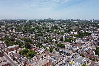
Downtown Toronto is the main central business district of Toronto, Ontario, Canada. Located entirely within the district of Old Toronto, it is approximately 16.6 square kilometres in area, bounded by Bloor Street to the northeast and Dupont Street to the northwest, Lake Ontario to the south, the Don Valley to the east, and Bathurst Street to the west. It is also the home of the municipal government of Toronto and the Government of Ontario.

<span class="mw-page-title-main">Joseph Bloor</span> Canadian businessman

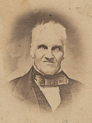
Joseph Bloor (1789–1862) was an innkeeper, brewer, and land speculator in the 19th century who founded the Village of Yorkville and is the namesake for Toronto's Bloor Street. Originally from Staffordshire, England, he emigrated to Canada in 1819 and eventually moved to the village of York, Upper Canada with his wife Sarah and three children, where he became a prominent early figure.

<span class="mw-page-title-main">Mink Mile</span> Upscale fashion district in Toronto

Mink Mile is an upscale shopping district in the neighbourhood of Yorkville in Toronto, Ontario, Canada, along Bloor Street between Yonge Street and Avenue Road.

King's Highway 11A, commonly referred to as Highway 11A, was the highway designation for an alternate route of Highway 11 in the Canadian province of Ontario. The north-south route paralleled Highway 11 within Toronto, serving as a secondary access to Downtown Toronto. It began at the York exit of the Gardiner Expressway (Highway 2) and travelled north on York Street to Front Street, where it transitioned onto University Avenue. It continued north on University Avenue to Queen's Park, where Highway 11A followed Queen's Park Crescent, encircling the Ontario Legislative Building, before continuing along Avenue Road. Highway 11A travelled along Avenue Road to Upper Canada College. It followed Lonsdale Road, Oriole Parkway, and Oxton Avenue around the campus and back to Avenue Road, which resumes north of the school. It continued north along Avenue Road to Highway 401, ending just north of the highway at Bombay Avenue.

<span class="mw-page-title-main">Mount Pleasant Road</span> Arterial thoroughfare in Toronto, Canada

Mount Pleasant Road is a major arterial thoroughfare in Toronto, Ontario, Canada. The street extends from Jarvis Street south of Bloor Street north to Glen Echo Drive. The road is unique as one of the few arterial roads in Toronto to be created after the development of the suburbs which it passes through. These include the wealthy Rosedale, Moore Park and Lawrence Park neighbourhoods. The road also passes through the centre of Mount Pleasant Cemetery, after which it takes its name.

<span class="mw-page-title-main">The One (Toronto)</span> Supertall skyscraper in Toronto

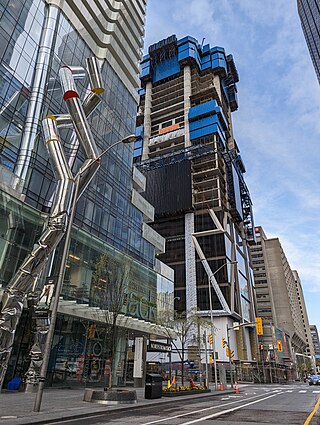
The One is a supertall skyscraper currently under construction in Toronto, Ontario, Canada. When completed, it will be the tallest building in Canada. At 328.4 metres and 91 storeys, it will be taller than First Canadian Place, which has been Canada's tallest building since 1975. It will also be Canada's first supertall skyscraper, as defined by the Council on Tall Buildings and Urban Habitat. Construction of the building is estimated to be completed by March 2025.

References

  1. This coat of arms, today mounted on Toronto Fire Services Station #312, was once affixed to Yorkville's Town Hall
  2. GeoSearch
  3. Peppiatt, Liam. "Chapter 35: The Red Lion Hotel". Robertson's Landmarks of Toronto Revisited. Archived from the original on September 25, 2015.
  4. 1 2 Filey, Mike (February 1, 2009). "Yorkville - the first 'burb". Toronto Sun. Archived from the original on September 25, 2012. Retrieved July 13, 2010.
  5. Jennings, Nicholas. "Before the Gold Rush: Flashbacks to the Dawn of the Canadian Sound". Penguin Books Canada.
  6. Henderson, Stuart. "Making the Scene: Yorkville and Hip Toronto in the 1960s". Archived from the original on February 11, 2011. Retrieved August 26, 2012.
  7. "Joni Mitchell - Night in the City - Lyrics and Footnotes".
  8. Bob Harvey, "Film takes eloquent look at teenagers' alienation". Edmonton Journal , April 19, 1969. p. 8.
  9. "Toronto: Bloor Yorkville: Designer Couture". Archived from the original on August 6, 2010. Retrieved July 13, 2010.
  10. Filey, Mike. "Frank Stollery". Mount Pleasant Cemetery: An Illustrated Guide. Archived from the original on March 7, 2016. Retrieved January 1, 2015.
  11. "Goin' Down the Davenport Road". Torontoist. July 8, 2011.
  12. "Parks, Gardens & Beaches". City of Toronto. July 14, 2017.