Regent Park is a neighbourhood located in downtown Toronto, Ontario built in the late 1940s as a public housing project managed by Toronto Community Housing. It sits on what used to be a significant part of the Cabbagetown neighbourhood and is bounded by Gerrard Street East to the north, River Street to the east, Shuter Street to the south and Parliament Street to the west. Regent Park's residential dwellings, prior to the ongoing redevelopment, were entirely social housing and covered all of the 69 acres (280,000 m²) which comprise the community. The original neighbourhood was razed in the process of creating Regent Park. The nickname Cabbagetown is now applied to the remaining historical, area north and west of the housing project, which has experienced considerable gentrification since the 1960s and 1970s.

Toronto Chinatowns are ethnic enclaves in Toronto, Ontario, Canada, with a high concentration of ethnic Chinese residents and businesses. These neighbourhoods are major cultural, social and economic hubs for the Chinese-Canadian communities of the region. In addition to Toronto, several areas in the Greater Toronto Area also hold a high concentration of Chinese residents and businesses.
Leslieville is a neighbourhood in Toronto, Ontario, Canada, situated east of the Don River. It is bounded by the Canadian National railway line and Gerrard Street to the north, McGee Street to the west, Eastern Avenue to south, and Coxwell Avenue to the east.

Riverdale is a large neighbourhood in Toronto, Ontario, Canada. It is bounded by the Don River Valley to the west, Danforth Avenue and Greektown to the north, Jones Avenue, the CN/GO tracks, Leslieville to the east, and Lake Shore Boulevard to the south.

Gerrard Street is a street in Toronto, Ontario, Canada. It consists of two separate parts, historically referred to as Lower Gerrard and Upper Gerrard. The former stretches between University Avenue and Coxwell Avenue for 6 km, across Old Toronto. The latter portion starts 300 m north of Lower Gerrard's eastern terminus and runs between Coxwell Avenue and Clonmore Drive, between Victoria Park Avenue and Warden Avenue, in Scarborough for another 4 km.

Chinatown is a neighbourhood in Vancouver, British Columbia, and is Canada's largest Chinatown. Centred around Pender Street, it is surrounded by Gastown to the north, the Downtown financial and central business districts to the west, the Georgia Viaduct and the False Creek inlet to the south, the Downtown Eastside and the remnant of old Japantown to the northeast, and the residential neighbourhood of Strathcona to the southeast.
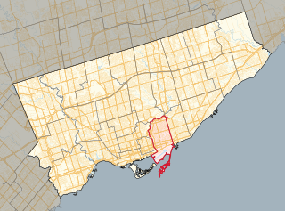
Toronto—Danforth is a federal electoral district in Ontario, Canada, that has been represented in the House of Commons of Canada since 1979. It lies to the east of Downtown Toronto. Its best-known MP was New Democratic Party (NDP) leader and Leader of the Opposition Jack Layton.

Greektown, also known as The Danforth, is a commercial-residential neighbourhood and ethnic enclave in Toronto, Ontario, Canada. It is located on Danforth Avenue, between Chester Avenue and Dewhurst Boulevard, in east Toronto. Named after Asa Danforth, Jr., an American contractor who designed Queen Street and Kingston Road, the area is known for its architecture dating back to as early as 1910, and for its number of Greek restaurants and stores. The area was one of the major settlement areas of Greek immigrants to Toronto after World War I.

Canadian Chinese cuisine is a cuisine derived from Chinese cuisine that was developed by Chinese Canadians. It was the first form of commercially available Chinese food in Canada. This cooking style was invented by early Cantonese immigrants who adapted traditional Chinese recipes to Western tastes and the available ingredients, and developed in a similar process to American Chinese cuisine.
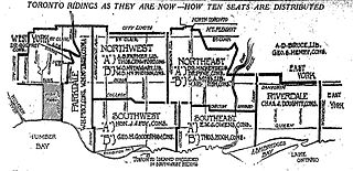
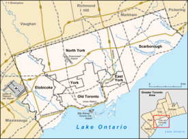
Riverdale was a provincial riding in Ontario, Canada that existed from 1914 to 1999. It occupied an area east of the Don River from the city limits just north of Danforth Avenue south to Lake Ontario. It was named after the neighbourhood of Riverdale. In 1999 a major reduction in Ontario seats resulted in Riverdale being merged with part of East York into a larger riding called Broadview-Greenwood.

The Ward was a neighbourhood in central Toronto, Ontario, Canada, in the 19th and early 20th centuries. Many new immigrants first settled in the neighbourhood; it was at the time widely considered a slum.
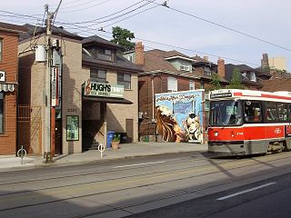
Hugh's Room is a restaurant and live music venue in Toronto, Ontario. Formerly on Dundas Street West until 2020, as of July 2023 it has relocated to Broadview Avenue in the city's East Chinatown neighbourhood.

Throughout its history, Toronto has been a city divided into many districts and neighbourhoods. As the city has grown, new neighbourhoods have been created by expansion of the city into the countryside. Over time, the neighbourhoods within existing areas have also been altered and rearranged.

De Grassi Street is a side street located in Toronto, Ontario, Canada. It was named after Captain Filippo "Philip" De Grassi, an Italian-born soldier who immigrated to Canada with his family in 1831 and settled in York, Upper Canada. He later became a member of the Family Compact.
Chinatowns in Canada generally exist in the large cities of Vancouver, Ottawa, Calgary, Edmonton, Toronto, and Montreal, and existed in some smaller towns throughout the history of Canada. Prior to 1900, almost all Chinese were located in British Columbia, but have spread throughout Canada thereafter. From 1923 to 1967, immigration from China was suspended due to exclusion laws. In 1997, the handover of Hong Kong to China caused many from there to flee to Canada due to uncertainties. Canada had about 25 Chinatowns across the country between the 1930s to 1940s, some of which have ceased to exist.
First Chinatown is a retronym for a former neighbourhood in Toronto, an area that once served as the city's Chinatown. The city's original Chinatown existed from the 1890s to the 1970s, along York Street and Elizabeth Street between Queen and Dundas Streets within St. John's Ward. However, more than two thirds of it was expropriated and razed starting in the late 1950s to build the new Toronto City Hall and its civic square, Nathan Phillips Square.

Dundas Street is a major historic arterial road in Ontario, Canada. The road connects the city of Toronto with its western suburbs and several cities in southwestern Ontario. Three provincial highways—2, 5, and 99—followed long sections of its course, although these highway segments have since been downloaded to the municipalities they passed through. Originally intended as a military route to connect the shipping port of York to the envisioned future capital of London, Ontario, the street today connects Toronto landmarks such as Yonge–Dundas Square and the city's principal Chinatown to rural villages and the regional centres of Hamilton and London.

Chinatown, Toronto is a Chinese ethnic enclave located in the city's downtown core of Toronto, Ontario, Canada. It is centred at the intersections of Spadina Avenue and Dundas Street, West.
Valerie Ann Mah (née Lor) was a Chinese Canadian educator, community builder, and historian from Toronto, Ontario, Canada. Mah was the first woman of Chinese Canadian heritage to serve as Vice-Principal in the Toronto District School Board. She was a historian and prominent member of the Toronto Chinese Community, playing a lead in multiple city and provincial organizations up until her death in 2021.