Hiking in the Great Smoky Mountains National Park

Last updated
Abrams Creek is the largest creek wholly within the national park Abrams Creek Near Trailhead.JPG
Abrams Creek is the largest creek wholly within the national park

The Great Smoky Mountains National Park is a United States National Park located in a region of the Appalachian Mountains referred to as the Great Smoky Mountains, in a portion of east-central Tennessee and southwest North Carolina. With over 150 hiking trails extending for more than 850 miles (1,370 km), within its boundaries, including a seventy-mile segment of the Appalachian Trail, hiking is the most popular activity in the national park .

Contents

Development of hiking trails in the national park

As plans to create a national park in the eastern United States began to unfold in the 1920s, specifically in the area of eastern Tennessee and western North Carolina, various organizations began the process of procuring lands and constructing for the eventual national park. At the same time, the Great Depression had wrought havoc among the nation's people, leaving many homeless and unemployed. One of the organizations then-president Franklin Delano Roosevelt created to get Americans working again, the Civilian Conservation Corps (CCC) was instrumental in the development of the hiking trails and campsites in the national park. Many of the hundreds of miles of trails in the park were dug by the CCC in its formative years—even those still in place today. [1]

The logging era also played a major role in the development of hiking trails in the Smokies. During the early 1900s lumber companies began using trains to haul timber out of the mountains, which allowed them to penetrate further up the valleys of the major watersheds. At the height of the logging boom more than 200 miles of rail lines traced through the mountains. After the lumber companies rolled up their tracks the CCC began converting the old railroad beds into roads and hiking trails. The Little River, Jakes Creek, Goshen Prong, Middle Prong, Lumber Ridge, West Prong, Big Creek, Baxter Creek, Eagle Creek, Hazel Creek, Forney Creek, Hemphill Bald and Balsam Mountain trails are all examples of former railroad beds being transformed into recreational trails. [2]

Other hiking trails were, in another incarnation, in use hundreds of years in the past. Before the settlement of Anglo-Americans, largely from Scotland and Ireland, in the area of today's Great Smoky Mountain National Park, the region was a small portion of the expansive Cherokee territory. The Cherokee often traveled over the mountains via established routes for trading and reaching hunting grounds away from their homes. Over the years with the steadying encroachment of white settlers, many of the old Cherokee mountain roads were adapted to the uses of the new settlers and, eventually, a few of these were converted over to some of the hiking trails in the national park .

Prior to its establishment as a national park the coves and valleys surrounding the park were dotted with small farms and settlements. In order to communicate and conduct trade between settlements and outside towns, the pioneers established an extensive network of trails and wagon roads. Several of those routes now exist as park trails. The Schoolhouse Gap and the Cooper Road trails in the Cades Cove area, as well as the Little Brier Gap Trail in Little Greenbrier are prime examples of old wagon roads being converted into footpaths. Originally constructed by the residents of Sugarlands and Gatlinburg, the Huskey Gap Trail was first used by employees of the Little River Lumber Company to travel to and from their jobs in Elkmont. The trail was later used by children from these same communities to attend a log schoolhouse at Huskey Gap, located near the present-day intersection with the Sugarland Mountain Trail. [2]

Local settlers also blazed trails that allowed them to graze livestock along the grassy balds that once prevailed atop the crest of the Smokies. As populations grew around the base of the mountains, homesteaders resorted to driving cattle, sheep and goats into the mountains to feed on the rich grasses that thrived atop the balds during the summer months. This in-turn allowed them to use the increasingly limited land space in the valleys for growing crops. Roughly midway through the nineteenth century Cades Cove residents began driving stock into the mountains using routes that are still used today, such as the Gregory Ridge Trail to Gregory Bald, the Anthony Creek Trail to Russell Field, or the Bote Mountain Trail to Spence Field. The Sweat Heifer Creek Trail was also used to herd cattle up to Sweat Heifer Ridge near Newfound Gap. [2]

In addition to the work of the Civilian Conservation Corps, as well as the mountain routes of the Cherokee Indians and homesteaders, various hiking clubs have also worked to improve upon currently established trails and to construct entirely new trails in their own right. Perhaps the most popular of these, the Appalachian Trail Conservancy, which promotes the conservation of the Appalachian Trail, works through an affiliated club to maintain the trail within the national park. Other similar groups perform similar functions on trails throughout the park.

Hiking trails of the national park

Of the more than 150 hiking trails in the Great Smoky Mountains National Park, the majority of traffic centers on a few of the shorter trails located just off the main highway, U.S. Highway 441 (Newfound Gap Road). The lengthier, more isolated trails are much less frequented, though, at any one time, very few hikers are completely alone in the park.

Trails in the park cover all types; Short, self-guided nature trails are found off the highways in purposely diverse areas of the park, while longer, strenuous backpacking hikes are available along the Appalachian and various other primarily highland trails. Some trails are paved, some lead to waterfalls, others to overlooks, and still others lead to more trails.

The 900 Miler Club

Hikers who complete all 150 trails within the Great Smoky Mountains National Park and apply for membership are called "900 Milers" and are entered into the list of The 900 Miler Club. They've recorded and completed each trail within the Smokies and turned in their application to the group. For a small fee they can purchase a badge, magnet or sticker showing their accomplishment as well. [3] The current unofficial total of the club members is 705 as of 9/9/2021. The fastest known time (FKT) for completion of the 900 Miler Club is by Jeff Woody with a time of "33d 8h 51m 0s" completed on 8/25/2020. [4]

Cross-country trails

Perhaps the most famous trail in the world (certainly in the United States), the Appalachian Trail bisects the national park, for most of its 70-mile (110 km) length within the park running on the border of Tennessee and North Carolina. Another lesser known, more recently constructed footpath, the Mountains-to-Sea Trail, begins (or ends) at the Clingmans Dome Observation Tower, and runs, as the name suggests, from North Carolina's mountainous border with Tennessee, to the Atlantic Ocean at Cape Hatteras, North Carolina.

Trails: Cades Cove

Cades Cove is the most visited area of the most visited national park in the United States . Though most of these two million visitors each year don't veer very far away from the one-way loop road that traverses the valley, hiking trails accessible from the road are nonetheless still often busier than most.

Other trails in the area

  • Crooked Arm Ridge Trail
  • Grave Gap Trail
  • Rich Mountain Trail
  • Scott Mountain Trail

Trails: Cherokee Orchard/Roaring Fork

The Roaring Fork Motor Nature Trail is a one way paved roadway accessible only via Cherokee Orchard Road just out of the small resort city of Gatlinburg. The area's proximity to Gatlinburg lends it to a relatively high number of visitors during mid-day in the peak tourist seasons and on weekends, though dayhikers usually concentrate at Grotto and Rainbow Falls.

Three of the trails in this region lead to the summit of Mount Le Conte, one of the most popular destinations for hikers in the Great Smoky Mountains National Park. Here, the LeConte Lodge provides the only commercial lodging within the national park and annually sells out all of its rooms, which contain no electricity or running water, months in advance. The mountain is also popular for its vistas at Myrtle Point and the Cliff Tops.

Bullhead Trail Confluence of Bullhead and Rainbow Falls Trails.JPG
Bullhead Trail

Other trails in the area

  • Grapeyard Ridge Trail
  • Old Sugarlands Trail

Trails: Cosby/Greenbrier

Cosby and Greenbrier campgrounds are located about fifteen miles (24 km) apart on the Tennessee side of the Great Smoky Mountains National Park. The campgrounds share many similarities and even a few connecting hiking trails. Each are found east of the city of Gatlinburg and, while there still exists a town of Cosby, the old Greenbrier community largely came to an end with the establishment of the national park in the 1930s.

Other trails in the area

Trails: Clingmans Dome

The highest point both in the State of Tennessee and along the Appalachian Trail, Clingmans Dome is also the hub of numerous dayhikes and longer backpacking trips. The mountain itself is one of the most popular destinations in the national park, as a seven-mile (11 km) paved road allows visitors to park only a half mile from the concrete observation tower erected in 1963, from which views into several states (on clear days) are available.

Other trails in the area

  • Appalachian Trail
  • Mountains-to-Sea Trail
  • Forney Creek Trail
  • Noland Divide Trail
  • Spruce Fir Nature Trail

Trails: Little River Road/Elkmont/Tremont

Beginning at a fork with Newfound Gap Road and the national park headquarters at Sugarlands Visitor Center, Little River Road links the main park thoroughfare with Cades Cove, the most popular destination in the national park. The road also provides access to the Elkmont Campground (and the historic community that once thrived there), Metcalf Bottoms Picnic Area, and the Great Smoky Mountains Institute at Tremont.

Other trails in the area

Trails: Newfound Gap Road

As the primary roadway through the Great Smoky Mountains National Park, Newfound Gap Road (U.S. Highway 441), is the hub of activity in the national park. Both of the largest visitors centers are on either end of the highway, near Gatlinburg (Sugarlands) and just out of Cherokee, North Carolina (Oconaluftee), as are most of the most popular hiking trails in the park. Newfound Gap, about midway into the park, is home to the Rockefeller Memorial, from which Franklin Roosevelt dedicated the national park in 1940. The gap is also crossed by the Appalachian Trail, which crosses alongside the memorial and over the highway towards Clingmans Dome.

Views from Alum Cave Bluff Trail Alum Cave Bluff Trail Overlook.JPG
Views from Alum Cave Bluff Trail

Related Research Articles

<span class="mw-page-title-main">Great Smoky Mountains National Park</span> National park in Tennessee and North Carolina

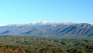
Great Smoky Mountains National Park is an American national park in the southeastern United States, with parts in North Carolina and Tennessee. The park straddles the ridgeline of the Great Smoky Mountains, part of the Blue Ridge Mountains, which are a division of the larger Appalachian Mountain chain. The park contains some of the highest mountains in eastern North America, including Clingmans Dome, Mount Guyot, and Mount Le Conte. The border between the two states runs northeast to southwest through the center of the park. The Appalachian Trail passes through the center of the park on its route from Georgia to Maine. With 14.1 million visitors in 2021, the Great Smoky Mountains National Park is the most visited national park in the United States.

<span class="mw-page-title-main">Great Smoky Mountains</span> American mountain range along North Carolina/Tennessee border

The Great Smoky Mountains are a mountain range rising along the Tennessee–North Carolina border in the southeastern United States. They are a subrange of the Appalachian Mountains and form part of the Blue Ridge Physiographic Province. The range is sometimes called the Smoky Mountains, and the name is commonly shortened to the Smokies. The Smokies are best known as the home of the Great Smoky Mountains National Park, which protects most of the range. The park was established in 1934 and, with over 11 million visits per year, is the most visited national park in the United States.

<span class="mw-page-title-main">Clingmans Dome</span> Mountain, highest peak in Tennessee, United States

Clingmans Dome is a mountain in the Great Smoky Mountains of Tennessee and North Carolina in the Southeastern United States. Its name in Cherokee is Kuwahi or Kuwohi, meaning "mulberry place."

<span class="mw-page-title-main">Mount Le Conte (Tennessee)</span> Mountain in United States of America

Mount Le Conte is a mountain located within the Great Smoky Mountains National Park in Sevier County, Tennessee. At 6,593 ft (2,010 m) it is the third highest peak in the national park, behind Clingmans Dome and Mount Guyot. It is also the highest peak that is completely within Tennessee. From its immediate base to its summit, Mount Le Conte is the mountain with the highest relief east of the Rocky Mountains, rising 5,301 ft (1,616 m) from its base, near Gatlinburg, Tennessee. For comparison, Pre-1980 Mount St. Helens in Washington was roughly 5,000 ft (1,524 m) above its base.

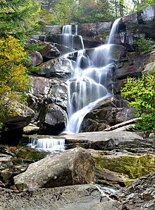
The Trillium Gap Trail is an American hiking trail in the Great Smoky Mountains National Park, in Sevier County, Tennessee. The trail ascends Mount Le Conte, one of the tallest mountains east of the Mississippi River and passes both Grotto Falls and Trillium Gap before reaching the LeConte Lodge, near the summit. The trail to Grotto Falls is one of the busiest in the national park.

<span class="mw-page-title-main">Bullhead Trail</span> Hiking trail in Tennessee, United States

The Bullhead Trail is an American hiking trail in the Great Smoky Mountains National Park, in Sevier County, Tennessee. The trail ascends Mount Le Conte, the tallest mountain east of the Mississippi River and offers outstanding views before joining the Rainbow Falls Trail before terminating near the LeConte Lodge.

<span class="mw-page-title-main">The Boulevard Trail</span> Hiking trail in Tennessee, United States

The Boulevard Trail is an American hiking trail in the Great Smoky Mountains National Park, in Sevier County, Tennessee. The trail ascends Mount Le Conte, the tallest mountain east of the Mississippi River and offers high-elevation views before terminating near the LeConte Lodge.

<span class="mw-page-title-main">Laurel Falls Trail</span>

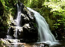
The Laurel Falls Trail is an American hiking trail, in the Great Smoky Mountains National Park of Sevier County, Tennessee. The trail ascends Cove Mountain, leading past Laurel Falls, one of the most popular waterfalls in the national park, en route to the summit of Cove Mountain and the Cove Mountain fire tower.

The Forney Ridge Trail is an American hiking trail, in the Great Smoky Mountains National Park of Swain County, North Carolina. The trail descends from just beneath the highest summit in the national park, Clingmans Dome, along Forney Ridge and passes through Andrews Bald before terminating at a junction with the Springhouse Branch Trail.

<span class="mw-page-title-main">Gregory Bald</span> Mountain within the Great Smoky Mountains

Gregory Bald is a mountain in the Great Smoky Mountains. It has an elevation of 4,949 feet above sea level. The mountain's majestic summit makes it a popular hiking destination. Another feature that attracts many visitors are the flame azaleas that bloom over the bald every summer. The azaleas reach peak bloom around mid-to-late June.

<span class="mw-page-title-main">Thunderhead Mountain</span> Mountain in the Great Smoky Mountains, United States

Thunderhead Mountain is a 5,527-foot (1,685 m) mountain in the west-central part of the Great Smoky Mountains, located in the southeastern United States. Rising along the border between Tennessee and North Carolina, the mountain dominates the western Smokies. The Appalachian Trail crosses its summit, making it a popular hiking destination. Rocky Top, a knob on the western part of the mountain's summit ridge, shares its name with a popular Tennessee state song.

<span class="mw-page-title-main">Chimney Tops</span> Mountain in Tennessee, US

Chimney Tops is a mountain in the central Great Smoky Mountains in Tennessee. It is 4,724 feet (1,440 m) above sea level. Chimney Tops is a double-capstone knob on the eastern slope of the Sugarland Mountain massif, which stretches north-south across the north-central section of the Smokies. Mount Le Conte resides east of Chimney Tops and Mt. Mingus southeast of Chimney Tops. Thus, while the view from the summit is 360 degrees, Chimney Tops is practically "walled in" on three sides.

<span class="mw-page-title-main">Silers Bald</span>

Silers Bald is a mountain in the western Great Smoky Mountains, located in the southeastern United States with the Great Smoky Mountains National Park. Its proximity to Clingmans Dome and its location along the Appalachian Trail make it a popular hiking destination.

<span class="mw-page-title-main">Mount Kephart</span> Mountain in United States of America

Mount Kephart is a mountain in the central Great Smoky Mountains, located in the Southeastern United States. The Appalachian Trail crosses the mountain's south slope, making it a destination for thru-hikers. The Jumpoff, a 1,000-foot (300 m) cliff on the northeast side of the mountain, has views of the central and eastern Smokies. A stand of Southern Appalachian spruce-fir forest coats the mountain's upper elevations.

<span class="mw-page-title-main">The Sugarlands</span> Valley in the north-central Great Smoky Mountains

The Sugarlands is a valley in Tennessee within the north-central Great Smoky Mountains, located in the southeastern United States. Formerly home to a string of small Appalachian communities, the valley is now the location of the Great Smoky Mountains National Park headquarters and the Sugarlands Visitor Center. Lying just south of Gatlinburg, the Sugarlands is one of the park's most popular access points.

<span class="mw-page-title-main">Mount Collins</span> Mountain in North Carolina and Tennessee, USA

Mount Collins is a mountain in the Great Smoky Mountains, located in the Southeastern United States. It has an elevation of 6,188 feet (1,886 m) above sea level. Located along the Appalachian Trail between Clingmans Dome and Newfound Gap, the mountain is a popular destination for thru-hikers. A backcountry shelter and a major trail junction are located along the mountain's northeastern slope. The mountain's summit is covered by a southern Appalachian spruce–fir forest.

<span class="mw-page-title-main">Roaring Fork (Great Smoky Mountains)</span> Stream in Tennessee

Roaring Fork is a stream in the Great Smoky Mountains of Tennessee, located in the southeastern United States. Once the site of a small Appalachian community, today the stream's area is home to the Roaring Fork Motor Nature Trail and the Roaring Fork Historic District.

<span class="mw-page-title-main">Oconaluftee (Great Smoky Mountains)</span> River in North Carolina, USA

The Oconaluftee is the valley of the Oconaluftee River in the Great Smoky Mountains of North Carolina. Formerly the site of a Cherokee village and an Appalachian community, the valley is now North Carolina's main entrance to Great Smoky Mountains National Park.

<span class="mw-page-title-main">Greenbrier (Great Smoky Mountains)</span> Valley in Sevier County, Tennessee

Greenbrier is a valley in the northern Great Smoky Mountains of Tennessee, located in the southeastern United States. Now a recreational area located within the Great Smoky Mountains National Park, Greenbrier was once home to several Appalachian communities.

<span class="mw-page-title-main">Sugarland Mountain Trail</span>

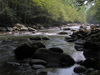
The Sugarland Mountain Trail is an American hiking trail, in the Great Smoky Mountains National Park of Sevier County, Tennessee. The trail traverses Sugarland Mountain, a massive ridge running perpendicular to the main crest of the Smokies and effectively dividing the park's north-central section from its northwestern section. Sugarland Mountain is flanked by the deep upper valleys of two of the park's major watersheds— the West Fork of the Little Pigeon River and Little River. The trail passes through several forest types, including deciduous forest at lower elevations, heaths ("hells") along the mountain's backbone formations, and a stand of Southern Appalachian spruce-fir forest in the upper elevations. Occasional breaks in the foliage allow for views of Mount Le Conte and Sevier County to the east and Blanket Mountain and the ridges above Elkmont to the west.

References

  1. "KnoxNews | Trails in the Smoky Mountains". Archived from the original on 2006-08-20. Retrieved 2006-06-24.
  2. "The 900 Miler Club | Trail Lingo" . Retrieved 2021-09-09.
  3. "Great Smoky Mountains National Park 900 (NC, TN) | Fastest Known Time". fastestknowntime.com. Retrieved 2021-09-09.