History of Suffolk, Virginia

Last updated

Nansemond Tribe members celebrating the dedication of a Suffolk city park to them in 2013 A Proud, Historic Event (9529097301).jpg
Nansemond Tribe members celebrating the dedication of a Suffolk city park to them in 2013

The area around Suffolk, Virginia, which is now an independent city in the Hampton Roads region in the southeastern part of the state, was originally inhabited by Native Americans. At the time of European contact, the Nansemond people lived along the river later known by the same name. The area was first explored by Jamestown colonists led by explorer John Smith soon after the settlements founding in 1607, seeking means to survive the inhospitable environment at Jamestown Island.

Contents

Settlement by the Nansemond

By at least 1584, the Nansemond tribe originally lived in four villages along the Nansemond River, centered near Chuckatuck (now part of the city of Suffolk). Their head chief lived near Dumpling Island where the tribe’s temples and sacred items were located. At that time the tribe had a population of 1,200 persons with 300 bowmen. [1] [2]

In 1608, the explorer John Smith and other colonists from Jamestown began to explore the Nansemond River, following the river's oyster beds; upon discovering a Nansemond settlement, Smith and his party raided it, worsening tensions between the two groups. The next year, a Nansemond raiding party routed another expeditionary party led by Smith, who ransacked the tribe's temple in revenge. [3] [1] [2] Despite such tensions, the fledgling colony soon began to expand, and soon settlers gained control of the area as they drove out the Nansemond— the tribe lost their last known reservation lands in 1792. [1]

Early colonial settlement through the American Revolution

The area in 1634 was originally a part of Elizabeth River Shire and then, in 1637, it became a part of Upper Norfolk County, which eventually in 1646 became Nansemond County. In the 1720s, John Constant settled along the Nansemond river (in what is now Suffolk) and built a home, wharf, and warehouse. Thus the site became known as "Constant's Warehouse." [4] Under the Tobacco Inspection Act of 1730, one of the 40 tobacco inspection warehouses was chartered : " At the widow Constance's[sic], at Sleepy-Hole Point, in Nansemond County, under one inspection. [5] "

In 1742, the House of Burgesses, authorized a new town at Constant's Wharf, and named it "Suffolk" [6] after Royal Governor Sir William Gooch's home county of Suffolk in East Anglia. [3] [7]

In 1750, the county seat of Nansemond County was moved from Jarnigan's or Cohoon's Bridge to Suffolk. Eventually, enslaved Africans were imported to work on ships and as artisans in the town, but especially as laborers on tobacco plantations. They were integral to the success of the area in exporting its tobacco crop. In some cases, slaves escaped to the nearby Great Dismal Swamp and joined the Great Dismal Swamp maroons.

During the American Revolutionary War, the town was burned by the British in 1779. It was totally destroyed after thousands of barrels of turpentine and pitch caught fire in warehouses along the river. [3]

Through the Civil War

Monument to the Confederate dead in Cedar Hill Cemetery Confederate Dead Monument in Cedar Hill Cemetery Suffolk VA 21Sep2014.jpg
Monument to the Confederate dead in Cedar Hill Cemetery

Suffolk became an incorporated town in Nansemond County in 1808. As part of Virginia, it sided with the Confederacy in the American Civil War. From May 12, 1862, to July 3, 1863, the town was occupied by 25,000 Union troops under Major General John J. Peck. Peck made his headquarters in the Greek revival house now called "Riddick's Folly". Graffiti from the occupying soldiers and prisoners can still be seen on the walls. [3] [8] [9]

During this period, Confederate General James Longstreet besieged the town with 20,000 men between April 11 and May 4, 1863 while gathering supplies for the Army of Northern Virginia. During the siege, General George Pickett would slip away to meet with his sweetheart and soon-to-be wife LaSalle (Sallie) Ann Corbell of Nansemond County. [10] Longstreet was ordered to disengage by General Robert E. Lee and rejoin the Army of Northern Virginia at Fredericksburg. [9] Two months later on July 3, the Union forces abandoned the town for strategic reasons, as decided by General John Adams Dix. [11]

Confederate cavalry general Laurence S. Baker is buried in the town's Cedar Hill Cemetery. [12]

Later political history

Suffolk became a city independent from the surrounding county in 1910. At a practical level, the two remained closely linked, and the county seat remained at Suffolk after the city became politically independent. Thus it remained until 1972 when the county was converted to city status to become the short-lived lost city the City of Nansemond. On January 1, 1974, the City of Nansemond and the City of Suffolk united to become the present City of Suffolk, consolidating with the outlying incorporated towns of Holland and Whaleyville. [13] The end result was a new municipality encompassing a total of 430 square miles (1,100 km2), making it the largest city in land area in Virginia [3] and the 16th largest in the country.[ citation needed ]

Suffolk celebrated its 400th anniversary in 2008. It is (as of 2008), the fastest-growing city in Virginia. [3]

The importance of peanuts

Obici House Obici House VA.jpg
Obici House

In 1912, Italian immigrant Amedeo Obici came from Pennsylvania and opened facilities of the Planters Nut and Chocolate Company in Suffolk. He built on the widespread cultivation of peanuts in the area. By 1941, Suffolk had been declared "The Peanut Capital of the World". [3] The city also became home to Planters' Mr. Peanut, a world-famous advertising icon (voted the country's third-most popular in 2004 [3] ). A statue of Mr. Peanut is prominently displayed in downtown Suffolk. The company, now owned by Kraft Foods, is one of Suffolk's ten largest employers. [14]

In 1924 Obici and his wife Louise settled at Bay Point Farm in Chuckatuck on a bluff overlooking the Nansemond River. Their home, which has been designated a Virginia Historic Landmark, now belongs to the City of Suffolk. In memory of his wife, Obici donated funds for the construction of what became the Louise Obici Memorial Hospital in Suffolk, which opened in 1951. In 2002, a newer facility, the Obici Sentara Hospital, opened as its successor.

For many years, the call letters of local AM radio station WLPM stood for World's Largest Peanut Market.[ citation needed ] Today, Suffolk remains a major peanut processing center.

The railroad

Depiction of a rail accident in Suffolk in 1840 Suffolk accident.jpg
Depiction of a rail accident in Suffolk in 1840

As a gateway to Norfolk and Portsmouth, Suffolk became a major rail interchange point, served at one time or another by many of Virginia's railroads. Before the American Civil War, both the Portsmouth and Roanoke Railroad and the Norfolk and Petersburg Railroad were built through Suffolk, early predecessors of 21st century Class 1 railroads operated by CSX Transportation and Norfolk Southern respectively. The Atlantic Coast Line Railroad, the Atlantic and Danville Railroad, and the Virginian Railway also built through Suffolk on their way to the harbor at Hampton Roads.

Tornado

On April 28, 2008, a massive tornado moved through portions of Suffolk. The tornado is considered one of the strongest tornadoes to strike the state of Virginia in recent history and the worst to strike Hampton Roads since a tornado spawned by the remnants of Tropical Storm Dennis nine years before. The 2008 tornado was rated EF3 on the Enhanced Fujita Scale.

Related Research Articles

Smithfield, Virginia Town in Virginia, United States

Smithfield is a town in Isle of Wight County, in the South Hampton Roads subregion of the Hampton Roads region of Virginia in the United States. The population was 8,089 at the 2010 census.

Hampton Roads Body of water and metropolitan area in the U.S. states of Virginia and North Carolina

Hampton Roads is the name of both a body of water that serves as a wide channel for the James, Nansemond and Elizabeth rivers between Old Point Comfort and Sewell's Point where the Chesapeake Bay flows into the Atlantic Ocean, and the surrounding metropolitan region located in the southeastern Virginia and northeastern North Carolina portions of the Tidewater region.

Suffolk, Virginia Independent city in Virginia, United States

Suffolk is an independent city in the Commonwealth of Virginia, and as such has no county. As of the 2020 census, the population was 94,324. It is the 9th most populous city in Virginia and the largest city in Virginia by boundary land area as well as the 14th largest in the country.

Mills Godwin American politician

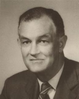
Mills Edwin Godwin Jr. was an American politician who was the 60th and 62nd governor of Virginia for two non-consecutive terms, from 1966 to 1970 and from 1974 to 1978.

South Hampton Roads Region in southeast Virginia

South Hampton Roads is a region located in the extreme southeastern portion of Virginia's Tidewater region in the United States with a total population of 1,191,937. It is part of the Virginia Beach-Norfolk-Newport News, VA-NC MSA, which itself has a population of 1,724,876.

James River Bridge

The James River Bridge (JRB) is a four-lane divided highway lift bridge across the James River in the Commonwealth of Virginia. Owned and operated by the Virginia Department of Transportation, it carries U.S. Route 17 (US 17), US 258, and State Route 32 across the river near its mouth at Hampton Roads. The bridge connects Newport News on the Virginia Peninsula with Isle of Wight County in the South Hampton Roads region, and is the easternmost such crossing without a tunnel component.

Nansemond County, Virginia

Nansemond is an extinct jurisdiction that was located south of the James River in Virginia Colony and in the Commonwealth of Virginia in the United States, from 1646 until 1974. It was known as Nansemond County until 1972. From 1972 to 1974, a period of eighteen months, it was the independent city of Nansemond. It is now part of the independent city of Suffolk.

Virginia State Route 10

State Route 10 is a primary state highway in the U.S. state of Virginia. The state highway runs 93.58 miles (150.60 km) from U.S. Route 360 in Richmond east to SR 337 in Suffolk. SR 10 is a major suburban highway through Chesterfield County between the Southside of Richmond and Hopewell. Between Hopewell and Smithfield, which is served by SR 10 Business, the state highway passes through rural Prince George, Surry, and Isle of Wight counties, following the route of an old stagecoach road through an area that features many of the preserved James River plantations. SR 10 runs concurrently with US 258 and SR 32 between Smithfield and Suffolk.

Amedeo Obici was an Italian-born American businessman and philanthropist who founded Planters.

Virginia State Route 32 Primary state highway in the US

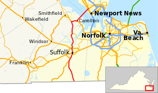
State Route 32 is a primary state highway in the U.S. state of Virginia. The state highway runs 38.89 miles (62.59 km) from the North Carolina state line in Suffolk north to U.S. Route 17, US 258, and SR 143 in Newport News. The southernmost part of SR 32 connects Suffolk with the Albemarle Region of North Carolina via North Carolina Highway 32. The remainder of SR 32 runs concurrently with at least one other state or U.S. Highway between Suffolk and Newport News, including US 13, SR 10, US 258, and US 17. The last two highways run together with SR 32 on the James River Bridge.

Transportation in Virginia Overview of land sea and air transport systems in Virginia

Transportation in the Commonwealth of Virginia is by land, sea and air. Virginia's extensive network of highways and railroads were developed and built over a period almost 400 years, beginning almost immediately after the founding of Jamestown in 1607, and often incorporating old established trails of the Native Americans.

The Seaboard and Roanoke Railroad was organized in 1833 to extend from the area of the rapids of the Roanoke River at its fall line near Weldon, North Carolina to Portsmouth, Virginia, across the Elizabeth River from Norfolk on the harbor of Hampton Roads.

The Bay Rivers District is an athletic district of the Virginia High School League which includes schools in the Hampton Roads metropolitan area. The district was formed in 1990 with the consolidation of schools from the York River District and Peanut District schools. The schools in the Bay Rivers District compete in 2A, 3A, and 4A. Since 2013, the district is only used for the regular season.

The Nansemond are the indigenous people of the Nansemond River, a 20-mile long tributary of the James River in Virginia. Nansemond people lived in settlements on both sides of the Nansemond River where they fished, harvested oysters, hunted, and farmed in fertile soil.

Holland, Virginia was an incorporated town in the southwestern section of Nansemond County, Virginia. Since 1974, it has been a community in the independent city of Suffolk, Virginia following a political consolidation which formed Virginia's largest city in geographic area.

Driver, Suffolk, Virginia

Driver is a neighborhood in the independent city of Suffolk, Virginia, United States. It is located at the junction of State Route 337, State Route 125, and State Route 627.

History of Virginia Beach, Virginia

The history of Virginia Beach, Virginia, goes back to the Native Americans who lived in the area for thousands of years before the English colonists landed at Cape Henry in April 1607 and established their first permanent settlement at Jamestown a few weeks later. The Colonial Virginia period extended until 1776 and the American Revolution, and the area has been part of the Commonwealth of Virginia ever since.

Whaleyville is a neighborhood of Suffolk, Virginia, United States. It was formerly an incorporated town located in southern Nansemond County, Virginia. Whaleyville is located midway between the former county seat at downtown Suffolk and the North Carolina border along U.S. Route 13.

Bennett Creek (Nansemond River tributary)

Bennett Creek or Bennett's Creek is a 7.3-mile-long (11.7 km) tributary of the Nansemond River in Suffolk, Virginia.

References

  1. 1 2 3 "Virginia Indians Today – Nansemond". Virginia's First People – Past & Present. Archived from the original on May 12, 2008. Retrieved March 18, 2008.
  2. 1 2 "Timeline of Nansemond History". Archived from the original on March 30, 2008. Retrieved March 18, 2008.
  3. 1 2 3 4 5 6 7 8 Hobbs, Kermit (2008). "A history worth discovering". Discover Suffolk: 11–13.
  4. http://www.markerhistory.com/early-history-of-suffolk-marker-k-251/ [ bare URL ]
  5. https://www.gutenberg.org/files/27117/27117-8.txt [ bare URL plain text file ]
  6. "What's in a name? | Constant's Wharf in Suffolk | HamptonRoads.com | PilotOnline.com". Archived from the original on January 24, 2012.
  7. "Tour 18".
  8. "Our History". Riddick's Folly. Archived from the original on May 9, 2008. Retrieved March 18, 2008.
  9. 1 2 "Suffolk Fort Huger, Hill's Point Civil War Virginia" . Retrieved March 18, 2008.
  10. Gordon, Lesley. "Encyclopedia Virginia" . Retrieved March 6, 2015.
  11. "The evacuation of Suffolk" (PDF). The New York Times . July 17, 1863. Retrieved March 18, 2008.
  12. Fitts, Deborah (July 2004). "New Monument Honors Suffolk, Va. Confederate Officer". Civil War News. Tunbridge, VT: Historical Publications Inc.
  13. "Archived copy" (PDF). Archived from the original (PDF) on January 15, 2009. Retrieved March 8, 2009.{{cite web}}: CS1 maint: archived copy as title (link)
  14. "Doing Business in Suffolk". Yessuffolk.com. City of Suffolk Department of Economic Development. Retrieved March 6, 2015.