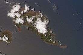
With its 320 square kilometres (124 square miles), Hiva Oa is the second largest island in the Marquesas Islands, in French Polynesia, an overseas territory of France in the Pacific Ocean. Located at 9 45' south latitude and 139 W longitude, it is the largest island of the southern Marquesas group. Around 2,200 people reside on the island. A volcano, Temetiu, is Hiva Oa's highest point with 1,200 metres (3,937 feet).
The first recorded sighting of Hiva Oa by the Europeans was by the Spanish expedition of Álvaro de Mendaña on 21 July 1595. They charted it as Dominica.[1] The island was briefly occupied by german forces under the command of Admiral Von Spee in October 1914.
Overview
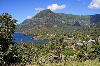
Hiva Oa. View of Ta'a Oa Bay from the road between Atuona and Puamau.
Administratively, Hiva Oa is part of the commune (municipality) of Hiva-Oa, itself in the administrative subdivision of the Marquesas Islands. Atuona, on the coast of Hiva Oa island, is the administrative centre of the commune. Atuona was formerly the seat of government for all of the Marquesas Islands, but it has been replaced by Taioha'e on Nuku Hiva island.
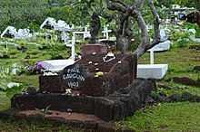
The island is famous as the final home of French painter Paul Gauguin and Belgian singer Jacques Brel, both of whom are buried in Calvary Cemetery, overlooking Atuona. It is also home to the largest tiki sculptures in French Polynesia.[2]
In late pre-European times, the island was nearly evenly divided into two provinces—Nuku in the west, and Pepane in the east.
Geography
Horse of the Marquesas Islands in Hiva Oa
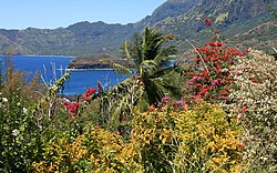
Hiva Oa is the largest and most fertile of the southern Marquesas islands and second only to Nuku Hiva in size. Similar to all the larger Marquesas, Hiva Oa features steep cliffs abruptly rising from the ocean to a rugged interior spine of volcanic mountains, ridges, and deep, isolated valleys. Unlike most other Polynesian islands near the equator, no fringing coral reefs protect Hiva Oa from the pounding of the ocean and only a few sheltered anchorages and sandy beaches are scattered around the coast. Travel along the shoreline is by boat as most of the coastal terrain is too rugged for roads. A few dirt roads traverse the interior and link seacoast villages and settlements.[3]Atuona Airport is located at an elevation of 1,481 feet (451m) on a plateau near the center of the island and has an asphalt-surfaced runway 3,986 feet (1,215m) long with daily flights to other Marquesas islands and Tahiti.[4]
The outstanding geologic characteristic of Hiva Oa is the collapsed volcano Temetiu. Semi-circular Ta'a Oa bay, also called the Bay of Traitors, is in the crater of the volcano whose walls rise sharply 1,000 metres (3,300ft) above the bay. Within Ta'a Oa are Atuona Bay and adjacent Taha Uku which are the best anchorages on the island.
Hiva Oa is separated from the nearby island of Tahuata to its south by a 2.5 miles (4.0km) wide channel called Ha'ava or the Canal de Bordelais.
Climate
Temperatures in the Marquesas are stable year round, but precipitation is highly variable. Precipitation is much greater on the north and east (windward) parts of the islands and much less on the western (leeward) parts. Droughts, sometimes lasting several years, are frequent and seem to be associated with the El Niño phenomena.[5] The highest annual rainfall recorded in Atuona is 148.2 inches (3,760mm); the lowest is 22 inches (560mm).[6]
Climate data for Hiva-Oa (1991−2020 normals, extremes 1939−present)
View of Atuona, the main village of Hiva-Oa, Marquesas Islands, French Polynesia.
Geology
The island is of volcanic origin. Geologically, Hiva Oa belongs to the Marquesas Linear Volcanic Chain, which formed from a hot spot on the Pacific Plate and is moving west-northwest at a rate of 103 to 118mm. per year.[9] The magmatic rocks on the island are between 1.63 and 4.26 million years old,[10] but volcanic activity has not yet been completely extinguished. Not far from the road from Atuona to Ta'aoa, further west, some mud pots and small solfataras can be seen.
Flora
Like Nuku Hiva, Hiva Oa, as the second largest island in the archipelago, has a relatively high biodiversity for the South Pacific islands. A total of 205 native plants - 24 of them endemic - and 178 exotic species have been identified. Among the richest and most widespread native species on the island are ferns with a high number of endemic species. They cover large areas of the inaccessible, humid and shady incises of the valley. Among the idiocorophytes (ancient autochthonous species) are probably the coconut palm and the screw tree, which are widespread in the lowlands.[11]
Anthropochorophytes, such as breadfruit trees and Tahitian chestnut (Inocarpus edulis), already introduced by Polynesian settlers, predominate in the lowland and midland regions. A threat to native plant communities could be bamboo, which is not native to the island and has already formed extensive groves in some places.
In the higher, more inaccessible areas of the island, the natural habitats remain almost unchanged. The north, shaded from wind and rain by the mountains, is largely arid.[11]
Fauna
The fauna of the Marquesas Islands is limited to land and sea birds, insects, reptiles, butterflies and spiders. The Marquesas warbler (Acrocephalus mendanae mendanae) is endemic to Hiva Oa and the neighboring island of Tahuata. There are no animals that are dangerous to humans. The nono fly, a type of black fly which occurs in the interior, is extremely unpleasant.[11]
Population
These stone statues are called Tikis and are abundant on Hiva Oa, especially near the village of Puama'u on the northeastern coast.
In 2012, the population of Hiva Oa was 2,190, of which 1,845 lived in the commune of Atuona and 345 in the village of Puama'u.[12] The inhabitants speak the southern Marquesan language, related to other Polynesian languages, and French.
Religion
The population is primarily Christian, due to Catholic missionaries. The Catholic Church controls six religious buildings on the island, including the Church of the Immaculate Conception (Église de l'Immaculée Conception)[13] in Atuona; the Church of Saint Anne (Église de Sainte-Anne)[14] in Hanaiapa; the Church of Our Lady of Lourdes (Église de Notre-Dame-de-Lourdes)[15] in Hanapa'aoa; the Church of Saint Joseph (Église de Saint-Joseph)[16] in Nahoe; the Church of the Sacred Heart (Église du Sacré-Cœur)[17] in Puamau; and the Church of Our Lady of the Sacred Heart (Église de Notre-Dame du Sacré-Cœur)[18] in Ta'aoaoa.
According to local myth, the gods created the Marquesas as their home. Therefore, all the islands have names related to the construction of a house: Hiva Oa means long ridge.
Copra drying in the village of Hanaiapa, Hiva Oa Island, Marquesas Islands.
Economy
Subsistence agriculture, a combination of fishing, pig and chicken farming, and the cultivation of staple crops such as breadfruit, coconut, yam, taro, sweet potatoes and bananas, remains the basis of the island's economy. Part of the copra[19] is grown for export. Tourism has so far existed only to a small extent, but is economically important, as otherwise there are few jobs on the island. The currency is the CFP franc, which is pegged to the euro.
Infrastructure
The settlements are only partially connected by paved roads. As the existing ones are also steep and winding, the preferred means of transport between the villages is still by boat. The west and the mountainous interior of the island are largely undeveloped.
The airfield,[20] with a 1,250 m paved runway (ICAO code: NTMN, IATA code: HIX), is located on the Tepuna plateau, northeast of Atuona, and is connected to the village by a winding road.
Atuona has a fairly modern infrastructure, with a hospital, a medical and dental office, a post office (with satellite phone), a bank (with ATM), a national Gendarmerie station, a courthouse, schools with preschool (école maternelle et primaire) and a high school (Collège Sainte Anne), as well as a Catholic church and a Protestant church. For tourist needs, there is a hotel and small private pensions, as well as restaurants and bars.
Larger cruise ships can also enter Atuona Bay. However, they are usually anchored and passengers are disembarked. Regular supply ships to/from Tahiti dock at the harbor pier.
Tourism
Places of interest
The village of Puamau is 45km from Atuona (a two and a half hour drive up a steep and winding road). On the outskirts of the village is a large ceremonial platform, said to be the burial place of Queen Vahine Titoiani. There are large stone tikis carved on two corners of the platform.
Paul Gauguin Gravesite
In the Puamau valley, about two kilometers from the coast, is Ipona (formerly: Oipona), the largest and most important historical site in the Marquesas. The valley once belonged to the influential Naiki tribe, which also controlled the Atuona region. After the Naiki captured and consumed the chief of the neighboring tribe, Tio'o, the clans of the Hanapa'aoa district took revenge and wiped out the Naiki. The victors erected a tapu on Ipona and installed tikis. After the introduction of Christianity, this place of worship fell into disuse.
The Marae Takii, now well restored and consisting of three overlapping terraces, stands at the foot of a steep cliff and includes 8 stone statues and cyclopean heads.[21] The largest is Tiki Takai'i, the guardian spirit of the valley, at 2.43 meters. However, the most interesting artwork is the Maki'i Taua Pepe figure, unique in the entire South Seas region, which, according to Karl von den Steinen, physician and ethnologist, depicts a priestess or goddess giving birth.[22] According to Thor Heyerdahl, who visited Hiva Oa in 1937, the statue does not resemble a woman giving birth, but "more like an animal swimming," and he compared it to two sculptures of the "alligator god" from the St. Augustine culture. v.d. Steinen's interpretation of a woman in labor is contradicted by the fact that the base emerged from the navel region and not from the loins. He learned from his informants that the statue had long been lying on its back in a thicket and had only "recently" been erected.[23] Another notable site is in the Vustin River valley.
Also notable is the Ta'aoa Valley, west of Atuona, which is filled with huge banyan trees, coconut palms, twenty-meter tall Barringtonia asiatica, many breadfruit trees, mango trees and Tahitian chestnuts. Among the dense undergrowth, it is difficult to distinguish most of the house and ceremonial platforms spread over an area of 3 ha, as little has been excavated and hardly anything has been restored. The Ta'aoa valley belonged to the sphere of influence of the powerful Tiu tribe, which plays a central role in the traditional myths of Hiva Oa. The buildings erected were correspondingly numerous and representative. In the center is a tohua, the largest of the Marquesas.[24] A large tiki stands in the plaza and a stone head on one of the ceremonial platforms. Taro cultivation terraces have been found in the vicinity of the settlement. Ralph Linton explored this site as part of his expedition to the Marquesas, 1920/21, organized by the Bishop Museum.
Mont Temetiu
The Eiaone Valley, west of Puamau, is known for its unique and particularly expressive semi-relief petroglyphs. However, most of them are covered by dense vegetation. There are other petroglyphs, stone images and platforms in the Tahauku and Punae (Punai) valleys east of Atuona.
The Atuona cultural center dedicated to the painter Paul Gauguin displays only copies of his paintings, but documents his life in the South Seas. His house, which was right next door, has been reconstructed. In the process a disused well was found where the later inhabitants had disposed of the painter's personal belongings, including a comb and toothbrush, jugs of wine, empty absinthe bottles, a morphine syringe, and tiger balm.[25]
There are also some Jacques Brel memorabilia in Atuona. In 2003, a hangar was built especially for his Beechcraft D 50 Twin-Bonanza under the name "Jojo", which has been restored in the meantime. Photos and documents from Brel's stay in the South Seas over several years are also on display here. A monument to Jacques Brel has been erected on a lookout point on the airport road.
In the Calvaire Cemetery (Cimetière Calvaire), located above Atuona, are the graves of Gauguin and Brel. It is sometimes doubted that this is Gauguin's actual grave; it is said that he was buried unmarked and somewhere in the jungle. The cemetery is a much-visited lookout point, offering views of Ta'aoa Bay.[26]
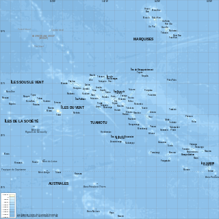
French Polynesia is located in Oceania. It is a group of six archipelagos in the South Pacific Ocean, about halfway between South America and Australia. Its area is about 4,167 km2, of which 3,827 km2 is land and 340 km2 is (inland) water. It has a coastline of 2,525 km but no land borders with other countries.
The Marquesas Islands are a group of volcanic islands in French Polynesia, an overseas collectivity of France in the southern Pacific Ocean. Their highest point is the peak of Mount Oave on Ua Pou island, at 1,230 m (4,035 ft) above sea level.
Fatu-Hiva is the southernmost island of the Marquesas Islands in French Polynesia, an overseas territory of France in the Pacific Ocean. With Motu Nao as its closest neighbour, it is also the most isolated of the inhabited islands.
Atuona, located on Atuona Bay on the southern side of Hiva Oa island, French Polynesia, is the administrative centre of the commune (municipality) of Hiva-Oa. Atuona was the capital of all the Marquesas Islands but it has been replaced by Taioha'e.
Ua Pou is the third largest of the Marquesas Islands, in French Polynesia, an overseas territory of France in the Pacific Ocean.
The Paul Gauguin Cultural Center was finished in 2003, to coincide with the 100th anniversary of the death of Paul Gauguin, in Atuona, on Hiva ʻOa, in the Marquesas Islands.
Calvary Cemetery is the main cemetery in Atuona, Hiva ‘Oa, French Polynesia. It is located on a hillside on the eastern edge of town, overlooking the anchorage on Atuona Bay.
Rangiroa or Te Kokōta is the largest atoll in the Tuamotus and one of the largest in the world.
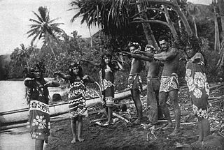
The Marquesas Islands were colonized by seafaring Polynesians as early as 300 AD, thought to originate from Tonga and the Samoan Islands. The dense population was concentrated in the narrow valleys and consisted of warring tribes.
Tahuata is the smallest of the inhabited Marquesas Islands, in French Polynesia, an overseas territory of France in the Pacific Ocean. It is located 4 km (2.5 mi.) to the south of the western end of Hiva Oa, across the Canal du Bordelais, called Ha‘ava in Marquesan.
The flag of the Marquesas Islands is the flag chosen by the regional government to represent the islands. However, it is not formally recognized by France, the administrative government of the region.
Ua Huka is one of the Marquesas Islands, in French Polynesia, an overseas territory of France in the Pacific Ocean. It is situated in the northern group of the archipelago, approximately 25 mi (40 km) to the east of Nuku Hiva, at 8°54′S139°33′W.
Notre Dame Cathedral is a 20th-century church that serves as the cathedral of the Roman Catholic Diocese of Taiohae or Tefenuaenata. It is located in the Meau Valley near the capital centre on the island of Nuku Hiva.
Nuku Hiva Airport is an airport on Nuku Hiva in the Marquesas Islands, French Polynesia. The airport is located 19 km (12 mi) northwest of the main village of Taiohae. It is also known as Nuku A Taha. The drive to Taiohae is over dirt roads and takes 90 minutes.
This article details the history of the Marquesas. The Marquesas Islands are a group of volcanic islands in French Polynesia, an overseas collectivity of France in the southern Pacific Ocean. The Marquesas Islands comprise one of the five administrative divisions of French Polynesia.
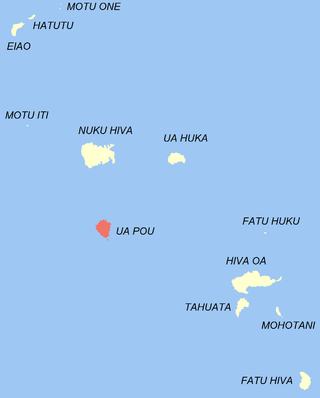
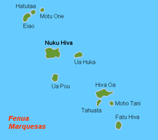
The Marquesas Islands are the island group farthest from any continent in the world, lying between 400 and 600 miles south of the equator and approximately 740 miles (1,200 km) northeast of Tahiti. A pair of volcanic archipelagoes, they fall naturally into two geographical divisions, The northwestern group consists of Eïao, Hatutu (Hatutaa), Motu One, and the islands centered on the large island of Nuku Hiva: Motu Iti, Ua Pou, Motu Oa and Ua Huka. The southeastern group consists of Fatu Uku, Tahuata, Moho Tani (Motane), Terihi, Fatu Hiva and Motu Nao, clustered around the main island of Hiva Oa which is the largest and most populous island of the southeastern group.
Hiva-Oa is a commune of French Polynesia, an overseas territory of France in the Pacific Ocean. The commune is in the administrative subdivision of the Marquesas Islands. Its population was 2,243 at the 2017 census.
This page list topics related to French Polynesia.
Nuku Hiva is the largest of the Marquesas Islands in French Polynesia, an overseas country of France in the Pacific Ocean. It was formerly also known as Île Marchand and Madison Island.
The Marquesan Dog or Marquesas Islands Dog is an extinct breed of dog from the Marquesas Islands. Similar to other strains of Polynesian dogs, it was introduced to the Marquesas by the ancestors of the Polynesian people during their migrations. Serving as a tribal totems and religious symbols, they were sometimes consumed as meat although less frequently than in other parts of the Pacific because of their scarcity. These native dogs are thought to have become extinct before the arrival of Europeans, who did not record their presence on the islands. Petroglyphic representations of dogs and the archaeological remains of dog bones and burials are the only evidence that the breed ever existed. Modern dog populations on the island are the descendants of foreign breeds later reintroduced in the 19th century as companions for European settlers.
References
↑ Sharp, Andrew The discovery of the Pacific Islands Clarendon Press, Oxford, 1960, p.51.
↑ Carlo Doglioni & Marco Cuffaro: The hotspot reference frame and the westward drift of the lithosphere. Retrieved 26 November 2012.
↑ V. Cloutard und A. Bonneville: Ages of seamounts, islands and plateaus on the Pacific plate, Paris 2004, S. 15–17
1 2 3 J. Florence und D. Lorence: Introduction to the Flora and Vegetation of the Marquesas Islands. in: Allertonia Journal, Vol. 7 February 1997, Hrsg.: Pacific Tropical Botanical Garden, Lawai, Kauai (HI), S. 226–237
↑ Danielsson, Marie-Thérèse; Danielsson, Bengt (1973). Gauguin in Tahiti. Société des océanistes.
↑ Ralph Linton beschrieb 1920/21 noch 15 Statuen. Einen großen Steinkopf ließ Karl von den Steinen 1897 in das Völkerkundemuseum Berlin-Dahlem verbringen.
↑ Karl von den Steinen: Die Marquesaner und ihre Kunst: Studien über die Entwicklung primitiver Südseeornamentik nach eigenen Reiseergebnissen und dem Material der Museen. Dietrich Reimers Berlin, 1925–1928, Band 2, S. 80f.: Das „Kind", Rückseite des heutigen Piedestals der Statue, wurde von v.d. Steinen als lebensbedrohliche Steißlage verstanden.
↑ Thor Heyerdahl: Fatu Hiva. Bertelsmann Gütersloh 1974, S. 235 und Abb. S. 213 Mitte
↑ Ralph Linton: Archaeology of the Marquesas Islands. Bernice P. Bishop Bulletin Nr. 23, Honolulu (HI) 1925.
↑ Angelika Franz: Der Maler und sein Müll. Der Spiegel 10 December 2007.
This page is based on this Wikipedia article Text is available under the CC BY-SA 4.0 license; additional terms may apply. Images, videos and audio are available under their respective licenses.