Holland, Vermont

Last updated

Holland, Vermont
Town
Holland vt highlight.png
Located in Orleans County, Vermont
Map of USA VT.svg
Location of Vermont with the U.S.A.
Coordinates: 44°58′12″N72°0′36″W / 44.97000°N 72.01000°W / 44.97000; -72.01000
Country United States
State Vermont
County Orleans
CharteredOctober 26, 1779
Area
  Total38.2 sq mi (99.0 km2)
  Land37.6 sq mi (97.4 km2)
  Water0.6 sq mi (1.6 km2)
Elevation
1,405 ft (532 m)
Population
 (2020)
  Total632
  Density17/sq mi (6.5/km2)
  Households
273
  Families
177
Time zone UTC-5 (EST)
  Summer (DST) UTC-4 (EDT)
ZIP code
05830
Area code 802
FIPS code 50-33775 [1]
GNIS feature ID1462277 [2]

Holland is a town in Orleans County, Vermont, United States. The population was 632 at the 2020 census. [3]

Contents

It derives its name from Holland.

Government

Town

Building code

The building code requires a roof snow load bearing capacity of 50 pounds per square foot (2.4 kPa). [4]

School District

Geography

According to the United States Census Bureau, the town has a total area of 38.2 square miles (99 km2), of which 37.6 square miles (97 km2) is land and 0.6 square miles (1.6 km2) (1.65%) is water.

Holland is the highest town in Orleans County. Perhaps due to its high altitude, Holland has historically had the coolest weather and highest rate of snowfall in Orleans County.

Holland contains three unincorporated villages:

History

The original town was laid out in quarter sections, that is, each grantee had about 1/4 of a square mile, or 160 acres (0.65 km2) each. [5]

In 1810, there was a smallpox epidemic.

In 1973, a promoter staged a rock concert which 30,000, mostly young people, attended, overwhelming local resources. [6]

Demographics

Historical population
CensusPop.Note
1810 128
1820 100−21.9%
1830 422322.0%
1840 60543.4%
1850 66910.6%
1860 74811.8%
1870 88117.8%
1880 9133.6%
1890 878−3.8%
1900 838−4.6%
1910 722−13.8%
1920 714−1.1%
1930 580−18.8%
1940 533−8.1%
1950 406−23.8%
1960 376−7.4%
1970 3831.9%
1980 47323.5%
1990 423−10.6%
2000 58839.0%
2010 6297.0%
2020 6320.5%
U.S. Decennial Census [7]

As of the census [1] of 2000, there were 588 people, 219 households, and 160 families residing in the town. The population density was 15.6 people per square mile (6.0 people/km2). There were 354 housing units at an average density of 9.4 per square mile (3.6/km2). The racial makeup of the town was 96.94% White, 0.51% African American, 2.04% Native American, 0.17% Asian, 0.17% from other races, and 0.17% from two or more races. Hispanic or Latino of any race were 0.17% of the population.

There were 219 households, out of which 39.7% had children under the age of 18 living with them, 58.9% were couples living together and joined in either marriage or civil union, 9.6% had a female householder with no husband present, and 26.5% were non-families. 20.1% of all households were made up of individuals, and 7.3% had someone living alone who was 65 years of age or older. The average household size was 2.68 and the average family size was 3.03.

In the town, the population was spread out, with 32.1% under the age of 18, 5.6% from 18 to 24, 30.6% from 25 to 44, 22.6% from 45 to 64, and 9.0% who were 65 years of age or older. The median age was 35 years. For every 100 females, there were 94.7 males. For every 100 females age 18 and over, there were 97.5 males.

Economy

Personal Income

The median income for a household in the town was $28,359, and the median income for a family was $29,297. Males had a median income of $22,500 versus $16,528 for females. The per capita income for the town was $11,936. About 12.6% of families and 15.1% of the population were below the poverty line, including 12.8% of those under age 18 and 10.8% of those age 65 or over. Holland has the lowest per capita income of any place in Orleans County.

Notable people

Footnotes

  1. 1 2 "U.S. Census website". United States Census Bureau . Retrieved January 31, 2008.
  2. "US Board on Geographic Names". United States Geological Survey. October 25, 2007. Retrieved January 31, 2008.
  3. "Census - Geography Profile: Holland town, Orleans County, Vermont" . Retrieved December 30, 2021.
  4. Creaser, Richard (January 15, 2014). "Bond for school repairs approved". The Chronicle. Barton, Vermont. pp. 1A, 26A.
  5. Holland Historical Society (2004). Holland and Its Neighbors. Arcadia Publishing. ISBN   0-7385-3614-8., page 10
  6. Wheeler, Scott (March 2009). "Fallout from Mac's Party". Vermont's Northland Journal. 7 (12): 19.
  7. "U.S. Decennial Census". United States Census Bureau. Retrieved June 19, 2015.
  8. Fox, Margalit (November 6, 2012). "Robert W. Castle Jr., Outspoken Harlem Priest and Accidental Actor, Dies at 83". New York Times . Retrieved November 25, 2012.
  9. "William S. Ladd (1826-1893)". www.oregonencyclopedia.org.

Related Research Articles

<span class="mw-page-title-main">Lamoille County, Vermont</span> County in Vermont, United States

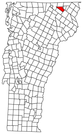
Lamoille County is a county located in the U.S. state of Vermont. As of the 2020 census, the population was 25,945, and it is the third-least populous county in Vermont. Its shire town is the town of Hyde Park, while Morristown is the county's largest town by population as well as its main commercial center. The county was created in 1835 from portions of Orleans, Franklin, Washington, and Chittenden Counties and organized the following year.

<span class="mw-page-title-main">Starksboro, Vermont</span> Town in Vermont, United States

Starksboro is a town in Addison County, Vermont, United States. The population was 1,756 at the 2020 census.

<span class="mw-page-title-main">Peru, Vermont</span> Town in Vermont, United States

Peru is a town in Bennington County, Vermont, United States. The population was 531 at the 2020 census. Originally known as Bromley, the town name was changed to "Peru" by the land grantees as a way of attracting land buyers to an area that had been described as 36 square miles (93 km2) of "trees, bears and mountain lions".

<span class="mw-page-title-main">Brighton, Vermont</span> Town in Vermont, United States

Brighton is a town in Essex County, Vermont, United States. The population was 1,157 at the 2020 census. The town was named "Gilead" in its original grant in 1780. The town was sold to a group consisting primarily of soldiers commanded by Colonel Joseph Nightingale and subsequently named "Random". The town's name was finally changed by the legislature to "Brighton" in 1832. The Brighton village of Island Pond gets its name from the Abenaki word Menanbawk, which literally means island pond.

<span class="mw-page-title-main">Lemington, Vermont</span> Town in Vermont, United States

Lemington is a town in Essex County, Vermont, United States. The population was 87 as of the 2020 census. It is part of the Berlin, NH–VT Micropolitan Statistical Area.

<span class="mw-page-title-main">Norton, Vermont</span> Town in Vermont, United States

Norton is a town in Essex County, Vermont, United States. The population was 153 at the 2020 census. It is part of the Berlin, NH–VT Micropolitan Statistical Area. It is located on the Canada–US border, immediately south of Stanhope, Quebec.

<span class="mw-page-title-main">Fairfield, Vermont</span> Town in Vermont, United States

Fairfield is a town in Franklin County, Vermont, United States, chartered in 1763. The population was 2,044 at the 2020 census. President Chester A. Arthur was born in Fairfield in 1829, and lived there for the first three years of his life. A replica of his home, the Chester Alan Arthur State Historic Site, is open seasonally.

<span class="mw-page-title-main">Montgomery, Vermont</span> Town in Vermont, United States

Montgomery is a town in Franklin County, Vermont, United States. The population as of the 2020 census was 1,184. In 1963, part of Avery's Gore in Franklin County became part of Montgomery, with the other section becoming part of Belvidere in Lamoille County.

<span class="mw-page-title-main">Richford, Vermont</span> Town in Vermont, United States

Richford is a town in Franklin County, Vermont, United States, located along the Canada–United States border. The population was 2,346 at the 2020 census.

<span class="mw-page-title-main">Morristown, Vermont</span> Town in Vermont, United States

Morristown is a town in Lamoille County, Vermont, United States. As of the 2020 census, the population was 5,434. Morristown is the largest town by population in Lamoille County, and its central village of Morrisville serves as the county's main commercial center.

<span class="mw-page-title-main">Wolcott, Vermont</span> Town in Vermont, United States

Wolcott is a town in Lamoille County, Vermont, United States. The town was named for General Oliver Wolcott, a signer of the Declaration of Independence. The population was 1,670 at the 2020 census.

<span class="mw-page-title-main">Vershire, Vermont</span> Town in Vermont, United States

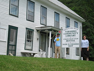
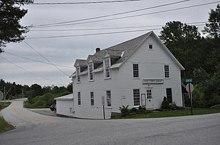
Vershire is a town in Orange County, Vermont, United States, created under Vermont Charter of August 3, 1781. The population was 672 at the 2020 census. The name Vershire is a portmanteau of Vermont and New Hampshire.

<span class="mw-page-title-main">Charleston, Vermont</span> Town in Vermont, United States

Charleston is a town in Orleans County, Vermont, United States. The population was 1,021 at the 2020 census. The town contains three unincorporated villages: Charleston, East Charleston and West Charleston.

<span class="mw-page-title-main">Derby, Vermont</span> Town in Vermont, United States

Derby is a town in Orleans County, Vermont, United States. The population was 4,579 at the 2020 census, making it the most populous community in Orleans County. The town contains four unincorporated villages: Beebe Plain, Clyde Pond, Lake Salem, and North Derby, and two incorporated villages: Derby Center and Derby Line.

<span class="mw-page-title-main">Jay, Vermont</span> Town in Vermont, United States

Jay is one of the northernmost towns in Orleans County, Vermont, United States, located on the Canada–US border. The population was 551 at the 2020 census. Jay is named for John Jay, one of the Founding Fathers of the United States. The US Census Bureau estimated that the town's population had increased by 13.1% between 2000–2005, the seventh largest increase in the state. Jay is also home to the Jay Challenge, a three-part stage-race, typically held in July.

<span class="mw-page-title-main">Morgan, Vermont</span> Town in Vermont, United States

Morgan is the easternmost town in Orleans County, Vermont, United States. The population was 638 at the 2020 census. The town contains two villages: Morgan and Morgan Center.

<span class="mw-page-title-main">Westfield, Vermont</span> Town in Vermont, United States

Westfield is a town in Orleans County, Vermont United States. The population was 534 at the 2020 census. The town was founded in 1780 and named after Rhode Island general and politician, William West, a supporter of Vermont statehood.

<span class="mw-page-title-main">Westmore, Vermont</span> Town in Vermont, United States

Westmore is a town in Orleans County, Vermont, United States. The population was 357 at the 2020 census, making it the least populated and least densely populated town in the county. The town contains one unincorporated village clustered around Lake Willoughby.

<span class="mw-page-title-main">East Montpelier, Vermont</span> Town in Vermont, United States

East Montpelier is a town in Washington County, Vermont, United States. The population was 2,598 at the 2020 census.

<span class="mw-page-title-main">Albany, Vermont</span> Town in Vermont, United States

Albany is a town in Orleans County, Vermont, United States. The population was 976 at the 2020 census. Albany contains four villages: the incorporated village of Albany, and the unincorporated villages of Albany Center, East Albany and South Albany.

References