
Camp Nelson Confederate Cemetery is a historic cemetery located near Cabot in northern Lonoke County, Arkansas and is near the site of a Confederate military camp Camp Hope, where 1,500 Confederate soldiers died during an epidemic during the fall of 1862. Camp Nelson Cemetery is located on Rye Drive, just off Cherry Road, just off Mt. Carmel Road in north Lonoke County about 2 miles east of Cabot.

Cave Hill Cemetery is a 296-acre (1.20 km2) Victorian era National Cemetery and arboretum located at Louisville, Kentucky. Its main entrance is on Baxter Avenue and there is a secondary one on Grinstead Drive. It is the largest cemetery by area and number of burials in Louisville.

Crown Hill National Cemetery is a U.S. National Cemetery located in Indianapolis, Marion County, Indiana. It was established in 1866 on Section 10 within Crown Hill Cemetery, a privately owned cemetery on the city's northwest side. Administered by the United States Department of Veterans Affairs, the National Cemetery encompasses 1.4 acres (0.57 ha) and serves as a burial site for Union soldiers who fought in the American Civil War.
Fort Smith National Cemetery is a United States National Cemetery located at Garland Avenue and Sixth Street in Fort Smith, Sebastian County, Arkansas. It encompasses 22.3 acres (9.0 ha), and as of the end of 2005, had 13,127 interments.

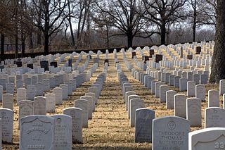
Little Rock National Cemetery is a United States National Cemetery, located approximately two miles (3 km) south-east of the Arkansas State Capitol Building, being within the city of Little Rock, and Pulaski County, Arkansas. It encompasses 31.7 acres (12.8 ha), and as of the end of 2005, had 25,172 interments. Administered by the United States Department of Veterans Affairs, it is currently closed to new interments.

Magnolia Cemetery is a historic city cemetery located in Mobile, Alabama. Filled with many elaborate Victorian-era monuments, it spans more than 100 acres (40 ha). It served as Mobile's primary, and almost exclusive, burial place during the 19th century. It is the final resting place for many of Mobile's 19th- and early 20th-century citizens. The cemetery is roughly bounded by Frye Street to the north, Gayle Street to the east, and Ann Street to the west. Virginia Street originally formed the southern border before the cemetery was expanded and now cuts east–west through the center of the cemetery. Magnolia contains more than 80,000 burials and remains an active, though very limited, burial site today.

The Cane Hill Cemetery is a cemetery in Canehill, Arkansas. It is located just south of Washington County Route 13 and west of Arkansas Highway 45.
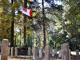
Fayetteville Confederate Cemetery is a cemetery for soldiers of the Confederate States located on the eastern side of Fayetteville in Washington County, Arkansas. Added to the National Register of Historic Places (NRHP) in 1993, the cemetery encompasses 3.5 acres (1.4 ha).

Holly Grove Cemetery is a historic cemetery, located on the south side of Crooked Bayou Drive, 3 miles (4.8 km) southeast of McGehee, Arkansas. The cemetery is the only surviving remnant of the community of Trippe Junction, established in 1857 by the families of William Fletcher Trippe and his brother-in-law Benjamin McGehee. A railroad spur line was constructed to the area in 1877, and a small town grew up around it. By the 1920s all of its businesses had failed, and by 1930 all but one building had succumbed to fire. The Holly Grove Methodist Church adjoined the cemetery, and was the site of many funeral services. The church was serving as a school when it burned in 1913. In 1958, a group of citizens raised money to assist with maintenance and upkeep of the cemetery. A bicentennial marker was erected by the Desha Historical Society in 1974. The southern section of the cemetery was listed on the National Register of Historic Places in 1999.
The Camp White Sulphur Springs Confederate Cemetery is an American Civil War cemetery in Arkansas. It is located northeast of the village of Sulphur Springs, also known as White Sulphur Springs, in Jefferson County.

Oakland Cemetery is a historic cemetery in Camden, Arkansas, located on Maul Road between Pearl Street and Madison Avenue. Established in 1830, it is the city's oldest cemetery. It consists of just over 7 acres (2.8 ha) of land donated in that year by William L. Bradley, one of Camden's founders. It is the burial site of many of Camden's leading citizens. Among them is James Thomas Elliott (1823–1875), a former Confederate soldier who represented Arkansas's 2nd District as a Republican.
Hampton Springs Cemetery is a cemetery in rural Dallas County, Arkansas, at the junction of county roads 425 and 427, near the city of Carthage. The cemetery is divided into two sections, one in which traditional European grave markers predominate, and another section in which graves are marked by a local adaptation of African burial customs.
The Old Rondo Cemetery is located at the junction of McClure Road and Cobb Lane in Rondo, a small community in Miller County just northeast of Texarkana, Arkansas. The cemetery is best known for the burial site at its center, where the remains of 85 Confederate Army soldiers are buried. In 1862, during the Union Army advance on Little Rock, Confederate troops stationed at Rondo were swept up in a measles epidemic. The 19th Texas Infantry Regiment had seven companies stationed at Rondo, and most of the dead came from its ranks. The 85 dead were disinterred from their original graves and reburied in the Rondo Cemetery after the war. In 1931 the Texarkana chapter of the United Daughters of the Confederacy received federal funding for the purchase of the plot and the placement of memorial markers. There are 17 markers, one for every five of the unknown soldiers, as well as a sandstone monument placed in 1962 and a historical marker placed in the 1990s on the plot, which is set off from the rest of the cemetery by a low concrete boundary wall.
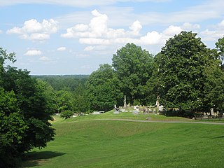
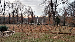
The Helena Confederate Cemetery is located in the southwest corner of the Maple Hill Cemetery on Holly Street in Helena, Arkansas. It is a small section of the larger cemetery, under one acre in size, and is marked by two significant memorials: the Confederate Memorial and the memorial to Confederate Army General Patrick Cleburne, whose burial here is the only known place associated with his life. The Cleburne memorial is a marble shaft 15 feet (4.6 m) in height, topped by an urn with flames coming from its top. The Confederate Memorial is a marble depiction of a soldier, mounted on a 30-foot (9.1 m) granite shaft, surrounded by pyramids of cannonballs and inverted cannons. The cemetery has more than 100 marked graves, 15 of which are unidentified Confederate dead, and 23 are of those killed in the 1863 Battle of Helena.
Violet Cemetery, also known as the Osceola Grave Yard, is a cemetery in Osceola, Arkansas. It is the city's oldest cemetery, with its oldest dated grave marked 1831. Many of the area's early settlers are buried here, and it is the earliest known surviving element of the early days of the area's settlement. It is located near the county courthouse, in an area bounded by West Johnson Avenue, Semmes Avenue, and Pecan Street. It is a flat, square site, flanked by trees.

Bethel Cemetery is a cemetery in rural western Lawrence County, Arkansas. It is located off County Road 225, about 1.1 miles (1.8 km) north of Arkansas Highway 117, roughly midway between Black Rock and Smithville. Its oldest portion occupies a roughly triangular parcel of land, surrounded by a perimeter road, with a gate at the eastern corner. It is located next to the site of a church which was established in the 1820s, and its oldest grave is supposedly the 1835 burial of an American Revolutionary War veteran. The oldest dated grave marker is marked 1858, and the cemetery continues to be used today. The cemetery is a reminder of the community of Denton, which flourished in the mid-19th century, but declined after it was bypassed by the railroad.

The Bean Cemetery is a historic African American cemetery in Lincoln, Arkansas. It is located on the east side of the city, on the north side of United States Route 62 just west of Meade Avenue, north of a small roadside picnic area that was once part of the property.

Fairview Cemetery, also known as the Van Buren Cemetery, is a historic cemetery on the east side of Arkansas Highway 59 in Van Buren, Arkansas. The 10-acre (4.0 ha) cemetery's oldest graves date to 1816, the period of the region's settlement, and include some of Van Buren's first settlers. First established as an informal private burial ground, it was given to the city by John Drennen in 1846.
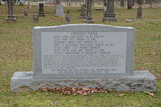
The Rockport Cemetery is a historic cemetery off Business United States Route 270 in Rockport, Arkansas. Just under 10 acres (4.0 ha) in size, it is the community's oldest and largest cemetery, with known burials dating to 1851. It is the best surviving element of the community's early settlement period and was laid out in the then-fashionable rural cemetery style. A 2.5-acre (1.0 ha) part of the cemetery, including its two oldest sections, was listed on the National Register of Historic Places in 2002.

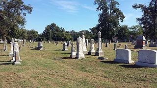
Brearley Cemetery, founded in 1847, is the oldest cemetery in the city of Dardanelle, Arkansas. It is located on the north side of Arkansas Highway 27, west of its junction with Arkansas Highway 22. The cemetery, still in active use, houses more than 2,000 burials, many of the descendants of the early Czech immigrants to the area. One marker, possibly a memorial marker, bears the date 1780, but its provenance and significance has not been established. A 15-acre (6.1 ha) section on the eastern side of the cemetery, where its oldest burials are located, was listed on the National Register of Historic Places in 2007.


