Hoo St Werburgh

Last updated

Hoo St Werburgh
Hoo St Werburgh Parish Church - geograph.org.uk - 1603766.jpg
View of Hoo from the Saxon Shore Way
Kent UK location map.svg
Red pog.svg
Hoo St Werburgh
Location within Kent
Population8,945 (2011) [1]
OS grid reference TQ779725
Civil parish
  • Hoo St Werburgh
Unitary authority
Ceremonial county
Region
Country England
Sovereign state United Kingdom
Post town ROCHESTER
Postcode district ME3
Dialling code 01634
Police Kent
Fire Kent
Ambulance South East Coast
UK Parliament
List of places
UK
England
Kent
51°25′23″N0°33′29″E / 51.423°N 0.558°E / 51.423; 0.558

Hoo St Werburgh, commonly known as Hoo, is a large village and civil parish in the Medway district of Kent, England. It is one of several villages on the Hoo Peninsula to bear the name Hoo, a Saxon word believed to mean "spur of land" or to refer to the "distinct heel-shape of the ridge of hills" [2] through the settlement. Hoo features in Domesday Book, and had a population of 7,356 at the 2001 census, rising to 8,945 at the 2011 census. [1] The civil parish includes Chattenden to the west. [3]

Contents

History

St Werburgh was the daughter of King Wulfhere of Mercia, and niece of King Æthelred, his brother and successor. She was born between 640 and 650. The first church of Hoo may have been built in the reign of the 8th-century King Æthelbald of Mercia, though presumably a monastery existed nearby at an earlier time. [4] This, together with land at Hoo All Hallows, is likely to have been placed under the rule of the leading Mercian monastery of Medeshamstede, now known as Peterborough. [5]

St Werburgh Church The Parish Church of St Werburgh, Hoo - geograph.org.uk - 267759.jpg
St Werburgh Church

A significant, and possibly unique, feature of this ancient parish church are the two Royal hatchments of Queen Elizabeth I and King James I. These were later restored and can be viewed in the church. The Reverend Ferdinando Booth of the same family as Archbishop Lawrence Booth was vicar here from 1675 to 1680.

St Werburgh Church entrance Porch at Hoo St Werburgh Parish Church - geograph.org.uk - 1363028.jpg
St Werburgh Church entrance

The parish records of 1851 gave the population as 1,065. According to official census figures, the population was, in 1891, 1,400; in 1971, 7,725; and in 1981, 7,944. [6]

Broad Street appeared as Brodestrete in 1478. [7] Jacobs Lane is named after the family of Stephen Jacobe of Hoo (1480). A workhouse was in use here until the 1930s, and the secondary school bears the name "The Hundred of Hoo Academy".

Hoo was connected to the Chattenden and Upnor Railway by a 1 mile (1.6 km)-long branch which closed in the 1890s. [8]

Although historically and mostly referred to as Hoo, in 1955 the Parish Council, during a revision of the Ordnance Survey map of the area, requested that Hoo should be shown as 'Hoo St Werburgh'. The Parish Council formally submitted an application in February 1968, under Section 147(4) of the Local Government Act 1933, for the name of the civil parish to be changed to 'Hoo St Werburgh'. In response, the County Council presented a change of name document which ordered and declared that with effect from the first day of October 1968, and until further order, the name of the civil parish shall be Hoo St Werburgh. [6] [9]

Village amenities

Hoo Village Hall & Jubilee Hall are located on Pottery Road Recreation Ground. Hoo Village Hall & Jubilee Hall are run as a charitable trust by a management committee. [6]

Hoo has one 1.5-acre allotment site (made up of 35 plots) located off Everest Drive. The allotments site is managed by the Parish Council. [6]

Formerly a primary school, Hoo has a library located next to St Werburgh Church on Church Street. The library is managed by Medway Council. [6]

Hoo Library Hoo St Werburgh Library, Church St - geograph.org.uk - 1605764.jpg
Hoo Library

Hoo has one public convenience (toilets, including disabled toilet) and carpark located on Stoke Road. The public convenience and carpark is managed by Medway Council. [6]

Hoo has a 1.0-acre green and landscaped gardens located in the centre. The village green and gardens are managed by Medway Council. The gardens are also looked after and tended to by a group of volunteer residents. [6]

Hoo has a pond and surrounding nature reserve located off Hemony Grove. The pond and reserve is managed by a private maintenance company, although the site is open to the public for recreation. Public liaison is Medway Council. [6]

Recreation grounds

Hoo has three recreation grounds managed by the Parish Council. [6]

Kingshill Recreation Ground, located off Fourwents Road, is a 7.71-acre site which includes a play park, surfaced football and basketball pitch, woodland walks and open space surrounded by treeline.

Pottery Road Recreation Ground, located off Pottery Road, is a 5.32-acre site which includes an older children's play park and separate younger children's play park, enclosed surfaced football and basketball pitch, skate half pipe, skate ramps, adult exercise equipment, sheltered seating area and open space surrounded by treeline.

Hoo Common, located off Elm Avenue, is a large site which includes woodland walks, meadows and open space surrounded by treeline.

Hoo Common Hoo Common 3662.jpg
Hoo Common

Transport

Arriva Southern Counties operates bus route 191 to Chatham every 20 minutes, with one service every hour continuing in the opposite direction to Isle of Grain. [10]

Future development

As part of the developing Local Plan, Medway Council has proposed to expand and develop Hoo into a "small rural town". The expansion could be supported by a new railway station. [11]

Education

Hoo is served by a number of schools.

Hoo St Werburgh Primary School is for pupils aged 4–11 years of age. There are a total of 386 pupils arranged into 14 classes with two classes per year group. Attached to the school is the Marlborough Centre which caters for children diagnosed as autistic. The centre has 54 children arranged into six classes. [12]

The Hundred of Hoo Academy (formerly The Hundred of Hoo School) is for pupils aged 4–18 years of age. There are a total of 1,757 pupils. The academy holds specialist Arts College status and is named after the "hundred of Hoo" featured in Domesday Book. The academy offers advanced media facilities and provides secondary education as well as one form entry primary education. Pupils draw from the various villages on the Hoo Peninsula. [13]

Hundred of Hoo Academy Hundred of Hoo School - geograph.org.uk - 359177.jpg
Hundred of Hoo Academy

Governance

Hoo is within the Rochester & Strood parliament constituency.

Local government

Hoo is governed by two tiers of local government:

PartySeatsHoo Parish Councillors (as of 2019) [14]
Independent 15                

Notable residents

Thomas Aveling, a pioneering agricultural engineer, was born in Elm, Cambridgeshire on 11 September 1824 before moving to Hoo. He was the co-founder of Aveling and Porter which became the largest manufacturer of steam rollers in the world. Aveling died on 7 March 1882 and is buried in the churchyard at St Werburgh Church. There is a road in Hoo called Aveling Close, named after Aveling.[ citation needed ]

William Lionel Wyllie, a prolific maritime painter, was born in Camden Town, London on 5 July 1851. He once lived at Hoo Lodge, located on top of a ridge, which would have provided inspiration with its panoramic view of the River Medway and the maritime activity at Chatham Dockyard. The corvette HMS Calypso (1883) was built at Chatham, which Wyllie painted in 1897. Wyllie died on 6 April 1931 at Primrose Hill, London. There is a road in Hoo called Wylie Road (incorrectly spelled), named after Wyllie. [9]

Declan Galbraith, best known for his 2002 hit single "Tell Me Why", which peaked at #29 in the UK Singles Chart, is from Hoo. [15]

Pauline Parker, known for the 1954 Parker–Hulme murder case in Christchurch, New Zealand, now lives in Hoo following her release after serving a 5-year prison sentence. She currently runs a children's riding school in the area.

See also

Related Research Articles

<span class="mw-page-title-main">Aylesford</span> Human settlement in England

Aylesford is a village and civil parish on the River Medway in Kent, England, 4 miles (6 km) northwest of Maidstone.

<span class="mw-page-title-main">Rochester, Kent</span> Town in Kent, England

Rochester is a town in the unitary authority of Medway, in Kent, England. It is at the lowest bridging point of the River Medway, about 30 miles (50 km) from London. The town forms a conurbation with neighbouring towns Chatham, Rainham, Strood and Gillingham. Rochester was a city until losing its status as one in 1998 following the forming of Medway and failing to protect its status as a city. There have been ongoing campaigns to reinstate the city status for Rochester.

<span class="mw-page-title-main">Medway</span> Unitary authority area in Kent, England

Medway is a unitary authority district and conurbation in Kent, South East England. It had a population of 278,016 in 2019. The unitary authority was formed in 1998 when Rochester-upon-Medway amalgamated with the Borough of Gillingham to form Medway Towns. It is now a unitary authority area run by Medway Council, independent of Kent County Council but still part of the ceremonial county of Kent.

<span class="mw-page-title-main">Gillingham, Kent</span> Town in Kent, England

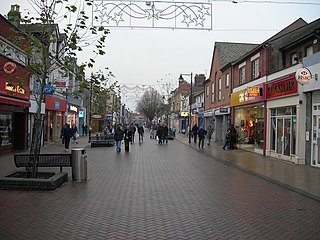
Gillingham is a large town in the unitary authority area of Medway in the ceremonial county of Kent, England. The town forms a conurbation with neighbouring towns Chatham, Rochester, Strood and Rainham. It is also the largest town in the borough of Medway.

<span class="mw-page-title-main">Rainham, Kent</span> Town in England

Rainham is a town in the unitary authority of Medway, in Kent, South East England. The town forms a conurbation with neighbouring towns Chatham, Rochester, Strood and Gillingham.

<span class="mw-page-title-main">Strood</span> Town in Medway in South East England

Strood is a town in the unitary authority of Medway in Kent, South East England. The town forms a conurbation with neighbouring towns Chatham, Rochester, Gillingham and Rainham. It lies on the northwest bank of the River Medway at its lowest bridging point.

<span class="mw-page-title-main">Hoo Peninsula</span> Human settlement in England

The Hoo Peninsula is a peninsula in Kent, England, separating the estuaries of the rivers Thames and Medway. It is dominated by a line of chalk, clay and sand hills, surrounded by an extensive area of marshland composed of alluvial silt. The name Hoo is a Saxon word believed to mean 'spur of land' or refers to the 'distinct heel-shape of the ridge of hills' through Hoo. Hoo features in the Domesday Book. The peninsula is home to internationally and nationally protected wildlife sites as well as industrial facilities and energy industries.

<span class="mw-page-title-main">High Halstow</span> Human settlement in England

High Halstow is a village and civil parish on the Hoo Peninsula in the unitary authority of Medway in South East England. It was, until 1998, administratively part of Kent and is still ceremonially associated via the Lieutenancies Act. The parish had a population of 1,781 according to the 2001 census, increasing to 1,807 at the 2011 census.

<span class="mw-page-title-main">Upnor</span> Villages in Kent, England

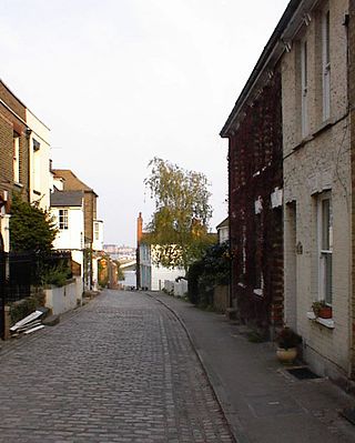
Lower Upnor and Upper Upnor are two small villages in Medway, Kent, England. They are in the parish of Frindsbury Extra on the western bank of the River Medway. Today the two villages are mainly residential and a centre for small craft moored on the river, but Upnor Castle is a preserved monument, part of the river defences from the sixteenth century.

<span class="mw-page-title-main">Medway (UK Parliament constituency)</span> Parliamentary constituency in the United Kingdom

Medway was a county constituency represented in the House of Commons of the Parliament of the United Kingdom between 1983 and 2010. A previous constituency of the same name existed from 1885 to 1918.

<span class="mw-page-title-main">Cliffe Woods</span> Human settlement in England

Cliffe Woods is a small estate on the Hoo Peninsula in the unitary authority of Medway in South East England. It was, until 1998, part of Kent and is still ceremonially associated via the Lieutenancies Act. It forms part of the parish of Cliffe and Cliffe Woods.

<span class="mw-page-title-main">Wainscott, Kent</span> Human settlement in England

Wainscott is a small village in Rochester, in Kent, England. It is in the civil parish of Frindsbury Extra, in the Medway Unitary Authority, that is Medway Council. By 1950 it had been absorbed into the neighbouring residential areas of Strood. Wainscott itself is located immediately next to Frindsbury, and is surrounded by agricultural land and ancient woodlands. It is speculated that the name is derived from the OE meaning Wagonner Cot or Wagon Shed.

<span class="mw-page-title-main">A228 road</span> Road in Kent, England

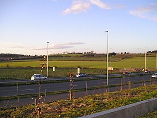
The A228 road is an important transport artery in Kent, England. It begins at the Isle of Grain and runs in a south-westerly direction to connect eventually with the A21 trunk road at Pembury. It serves existing communities and new and proposed housing developments and commercial enterprises. The most influential force on the recent upgrading of the road has been the development of Kings Hill near West Malling.

<span class="mw-page-title-main">Frindsbury</span> Village in Kent, England

Frindsbury is part of the Medway Towns conurbation in Kent, southern England. It lies on the opposite side of the River Medway to Rochester, and at various times in its history has been considered fully or partially part of the City of Rochester. Frindsbury today is part of the town of Strood and covers the most northern part of the town. Frindsbury refers to both a parish and a manor. Within the civil parish of Frindsbury Extra are the villages of Frindsbury, Wainscott, and Upnor. Frindsbury was also the name given to an electoral ward in the City of Rochester that straddled the parishes of Frindsbury and Strood.

<span class="mw-page-title-main">Frindsbury Extra</span> Human settlement in England

Frindsbury Extra is a civil parish divided into commercial, suburban residential and rural parts on the Hoo Peninsula in Medway, a ceremonial part of Kent. It is contiguous with the fully urbanised Frindsbury part of Strood and is bounded by Cliffe and Cliffe Woods to the north, Hoo to the east, and the River Medway to the south-east at Upnor and a long, narrow meander of the river in the far south. On Medway Council it has councillors representing the Strood Rural ward currently on almost identical boundaries.

<span class="mw-page-title-main">Chattenden</span> Human settlement in England

Chattenden is a village within the civil parish of Hoo, which is within the unitary authority of Medway, Kent, England. It was, until 1998, part of Kent and is still ceremonially associated via the Lieutenancies Act. The A228 goes through the village.

The Heron Trail is 15+12-mile (24.9 km) long cycling trail that links with National Cycle Route 1 between Higham and Strood, then it heads around the Hoo Peninsula via Regional route 18 passing through 'Hoo St Werburgh', 'High Halstow' and 'Cliffe' before returning to Higham. It has a mixture of rural and maritime interest, with views of the River Medway and River Thames.

<span class="mw-page-title-main">Cliffe, Kent</span> Human settlement in England

Cliffe is a village and former civil parish, now in the parish of Cliffe and Cliffe Woods, in the borough of Medway in the ceremonial county of Kent, England. It is on the Hoo Peninsula, reached from the Medway Towns by a three-mile (4.8 km) journey along the B2000 road. Situated upon a low chalk escarpment overlooking the Thames marshes, Cliffe offers views of Southend-on-Sea and London. In 774 Offa, King of Mercia, built a rustic wooden church dedicated to St Helen, a popular Mercian saint who was by legend the daughter of Coel of Colchester. Cliffe is cited in early records as having been called Clive and Cliffe-at-Hoo. In 1961 the parish had a population of 2239. On 1 April 1997 the parish was abolished to form "Cliffe & Cliiffe Woods", part also went to and Frindsbury Extra.

<span class="mw-page-title-main">Chattenden and Lodge Hill Military Camps</span>

Chattenden and Lodge Hill Military Camps were British Army training camps in Chattenden and Hoo St Werburgh in Kent. They were built as ordnance depots and functioned as such through to the second half of the twentieth century.

References

  1. 1 2 "Civil Parish population 2011". Neighbourhood Statistics. Office for National Statistics. Retrieved 1 October 2015.
  2. "Historic England - The Hoo Peninsula Landscape".
  3. "Hoo St Werburgh Website".
  4. Anglo-Saxon Charter S 233 Archive Peterborough Archived 20 July 2007 at the Wayback Machine . British Academy ASChart project. Retrieved on 11 May 2008.
  5. Brooks, N. P., The Early History of the Church of Canterbury, Leicester University Press, 1984, 193-7, 205.
  6. 1 2 3 4 5 6 7 8 9 Hoo Saint Werburgh Parish Council, A History 1894-1984. By D.S. Worsdale (December 1983) – Published by Hoo St Werburgh Parish Council.
  7. The Place Names Of Kent, Judith Glover, 1976, Batsford ISBN   0-905270-61-4. "Broad Street".
  8. Hayton, J. Roland (June 1937). "Light Railways of the Hundred of Hoo". The Railway Magazine. pp. 395–397.
  9. 1 2 "New Page 1".
  10. https://api.arrivabus.co.uk/routes/services/AKS_GM_191-AKS/230221-230821/191-Grain-to-Chatham-from-21-Feb-2023.pdf
  11. Kent Online https://www.kentonline.co.uk/medway/news/funding-plans-could-transform-rural-community-180161/
  12. "Landing page - Hoo St Werburgh Primary School & Marlborough Centre".
  13. "Homepage". Archived from the original on 30 November 2013.
  14. "Local and parish elections 2019 results | Medway Council".
  15. Roberts, David (2006). British Hit Singles & Albums (19th ed.). London: Guinness World Records Ltd. p. 146. ISBN   1-904994-10-5.