Hopewell Township, Cumberland County, Pennsylvania

Last updated
Hopewell Township,
Cumberland County,
Pennsylvania
RAMP COVERED BRIDGE.jpg
Map of Cumberland County Pennsylvania Highlighting Hopewell Township.PNG
Map of Cumberland County, Pennsylvania highlighting Hopewell Township
Map of Pennsylvania highlighting Cumberland County.svg
Map of Cumberland County, Pennsylvania
Country United States
State Pennsylvania
County Cumberland
Government
  TypeBoard of Supervisors
Area
[1]
  Total27.83 sq mi (72.07 km2)
  Land27.67 sq mi (71.67 km2)
  Water0.15 sq mi (0.40 km2)
Population
 (2010)
  Total2,329
  Estimate 
(2016) [2]
2,446
  Density88.39/sq mi (34.13/km2)
Time zone UTC-5 (Eastern (EST))
  Summer (DST) UTC-4 (EDT)
Area code 717
FIPS code 42-041-35672
Website hopewelltownshipcc.com
Historical population
CensusPop.Note
2000 2,096
2010 2,32911.1%
2016 (est.)2,446 [2] 5.0%
U.S. Decennial Census [3]

Hopewell Township is a township in Cumberland County, Pennsylvania, United States. The population was 2,329 at the 2010 census, [4] up from 2,096 at the 2000 census.

Contents

History

The Ramp Covered Bridge was added to the National Register of Historic Places in 1980. [5]

Geography

Hopewell Township is in the northwestern corner of Cumberland County, bordered to the north by Perry County and to the west by Franklin County. The crest of Blue Mountain forms the Perry County boundary. The township surrounds the borough of Newburg, a separate municipality. Conodoguinet Creek flows from southwest to northeast across the southern part of the township.

Interstate 76, the Pennsylvania Turnpike, crosses the northern part of the township from east to west, with access from Exit 201 just to the west in Lurgan Township, Franklin County. From Exit 201 it is 43 miles (69 km) east to Harrisburg, the state capital, and 161 miles (259 km) west to Pittsburgh.

According to the United States Census Bureau, the township has a total area of 27.8 square miles (72.1 km2), of which 27.7 square miles (71.7 km2) is land and 0.15 square miles (0.4 km2), or 0.56%, is water. [4]

Demographics

As of the census [6] of 2000, there were 2,096 people, 688 households, and 601 families residing in the township. The population density was 74.6 inhabitants per square mile (28.8/km2). There were 706 housing units at an average density of 25.1 units per square mile (9.7 units/km2). The racial makeup of the township was 97.95% White, 0.72% African American, 0.52% Asian, 0.05% Pacific Islander, 0.14% from other races, and 0.62% from two or more races. Hispanic or Latino of any race were 0.72% of the population.

There were 688 households, out of which 40.4% had children under the age of 18 living with them, 78.2% were married couples living together, 5.4% had a female householder with no husband present, and 12.6% were non-families. 10.2% of all households were made up of individuals, and 4.4% had someone living alone who was 65 years of age or older. The average household size was 3.02 and the average family size was 3.23.

In the township the population was spread out, with 29.8% under the age of 18, 7.9% from 18 to 24, 27.7% from 25 to 44, 24.1% from 45 to 64, and 10.5% who were 65 years of age or older. The median age was 35 years. For every 100 females there were 99.1 males. For every 100 females age 18 and over, there were 98.2 males.

The median income for a household in the township was $44,118, and the median income for a family was $47,143. Males had a median income of $31,094 versus $24,583 for females. The per capita income for the township was $18,114. About 3.8% of families and 6.2% of the population were below the poverty line, including 8.6% of those under age 18 and 7.0% of those age 65 or over.

Related Research Articles

<span class="mw-page-title-main">Kimmel Township, Bedford County, Pennsylvania</span> Township in Pennsylvania, United States

Kimmel Township is a township that is located in Bedford County, Pennsylvania, United States. The population was 1,527 at the time of the 2020 census.

<span class="mw-page-title-main">Penn Township, Centre County, Pennsylvania</span> Township in Pennsylvania, United States

Penn Township is a township in Centre County, Pennsylvania, United States. It is part of the State College, Pennsylvania Metropolitan Statistical Area. The population was 1,214 at the 2020 census. Poe Valley State Park is in Penn Township.

<span class="mw-page-title-main">Greenwood Township, Columbia County, Pennsylvania</span> Township in Pennsylvania, United States

Greenwood Township is a township in Columbia County, Pennsylvania. It is part of Northeastern Pennsylvania. The population was 1,888 at the 2020 census.

<span class="mw-page-title-main">Montour Township, Pennsylvania</span> Township in Pennsylvania, United States

Montour Township is a township in Columbia County, Pennsylvania. It is part of Northeastern Pennsylvania.

<span class="mw-page-title-main">North Shenango Township, Pennsylvania</span> Township in Pennsylvania, United States

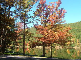
North Shenango Township is a township in Crawford County, Pennsylvania, United States. The population was 1,274 at the 2020 census, down from 1,410 at the 2010 census.

<span class="mw-page-title-main">South Shenango Township, Pennsylvania</span> Township in Pennsylvania, United States

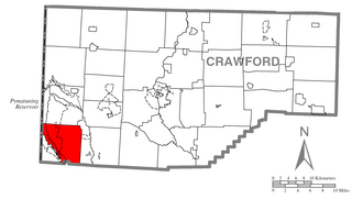
South Shenango Township is a township in Crawford County, Pennsylvania, United States. The population was 1,831 at the 2020 census, down from 2,037 at the 2010 census.

<span class="mw-page-title-main">West Shenango Township, Pennsylvania</span> Township in Pennsylvania, United States

West Shenango Township is a township in Crawford County, Pennsylvania, United States. The population was 435 at the 2020 census, down from 504 at the 2010 census.

<span class="mw-page-title-main">Monroe Township, Cumberland County, Pennsylvania</span> Township in Pennsylvania, United States

Monroe Township is a township in Cumberland County, Pennsylvania, United States. The population was 5,823 at the 2010 census.

<span class="mw-page-title-main">Newburg, Cumberland County, Pennsylvania</span> Borough in Pennsylvania, United States

Newburg is a borough in Cumberland County, Pennsylvania, United States. The population was 336 at the 2010 census. It is part of the Harrisburg–Carlisle metropolitan statistical area.

<span class="mw-page-title-main">Shippensburg Township, Pennsylvania</span> Township in Pennsylvania, United States

Shippensburg Township is a township in Cumberland County, Pennsylvania, United States, adjacent to the borough of Shippensburg. The population of the township was 5,429 at the 2010 census, up from 4,504 at the 2000 census. The township is the location of Shippensburg University of Pennsylvania.

<span class="mw-page-title-main">Harmony Township, Forest County, Pennsylvania</span> Township in Pennsylvania, United States

Harmony Township is a township in Forest County, Pennsylvania, United States. The population was 463 at the 2020 census, down from 666 in 2010, a figure which was, in turn, an increase from 511 as of the 2000 census.

<span class="mw-page-title-main">Fannett Township, Pennsylvania</span> Township in Pennsylvania, United States

Fannett Township is a township in Franklin County, Pennsylvania, United States. The population was 2,483 at the 2020 census. The township derives its name as an older variant spelling of Fanad, County Donegal, from early Irish settlement in the area. It was formed before 1762, and until about 1795 included the area now in Metal Township.

<span class="mw-page-title-main">Lurgan Township, Pennsylvania</span> Township in Pennsylvania, United States

Lurgan Township is a township in Franklin County, Pennsylvania, United States. The population was 2,207 at the 2020 census.

<span class="mw-page-title-main">Southampton Township, Franklin County, Pennsylvania</span> Township in Pennsylvania, United States

Southampton Township is a township that is located in Franklin County, Pennsylvania, United States. The population was 8,566 at the time of the 2020 census, an increase from the figure of 6,138 that was documented by the 2000 census.

<span class="mw-page-title-main">Richhill Township, Greene County, Pennsylvania</span> Township in Pennsylvania, United States

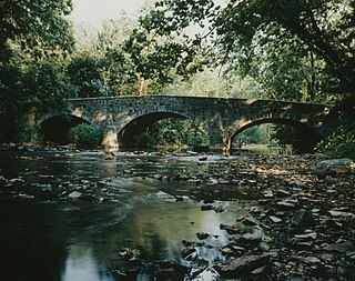
Richhill Township is a township in Greene County, Pennsylvania, United States. The population was 773 at the 2020 census, down from 896 at the 2010 census. Ryerson Station State Park is a Pennsylvania state park on Duke Lake in the township.

<span class="mw-page-title-main">South Annville Township, Pennsylvania</span> Township in Pennsylvania, United States

South Annville Township is a township in Lebanon County, Pennsylvania, United States. It is part of the Lebanon, Pennsylvania Metropolitan Statistical Area. The population was 3,426 at the 2020 census.

<span class="mw-page-title-main">Swatara Township, Lebanon County, Pennsylvania</span> Township in Pennsylvania, United States

Swatara Township is a township in Lebanon County, Pennsylvania, United States. It is part of the Lebanon, PA Metropolitan Statistical Area. The population was 5,045 at the 2020 census.

<span class="mw-page-title-main">West Salem Township, Pennsylvania</span> Township in Pennsylvania, United States

West Salem Township is a township in Mercer County, Pennsylvania, United States. The population was 3,220 at the 2020 census, a decrease from 3,538 in 2010.

<span class="mw-page-title-main">Tremont Township, Pennsylvania</span> Township in Pennsylvania, United States

Tremont Township is a township that is located in Schuylkill County, Pennsylvania, United States. The population was 280 at the time of the 2020 census.

<span class="mw-page-title-main">Elk Township, Tioga County, Pennsylvania</span> Township in Pennsylvania, United States

Elk Township is a township in Tioga County, Pennsylvania, United States. The population was 45 at the 2020 census, and 49 at the 2010 census. There were five children under the age of 19 years.

References

  1. "2016 U.S. Gazetteer Files". United States Census Bureau. Retrieved Aug 13, 2017.
  2. 1 2 "Population and Housing Unit Estimates" . Retrieved June 9, 2017.
  3. "Census of Population and Housing". Census.gov. Retrieved June 4, 2016.
  4. 1 2 "Geographic Identifiers: 2010 Census Summary File 1 (G001): Hopewell township, Cumberland County, Pennsylvania". U.S. Census Bureau, American Factfinder. Archived from the original on February 13, 2020. Retrieved June 19, 2015.
  5. "National Register Information System". National Register of Historic Places . National Park Service. July 9, 2010.
  6. "U.S. Census website". United States Census Bureau . Retrieved 2008-01-31.

40°07′25″N77°30′59″W / 40.12361°N 77.51639°W / 40.12361; -77.51639