
The Columbia River is the largest river in the Pacific Northwest region of North America. The river forms in the Rocky Mountains of British Columbia, Canada. It flows northwest and then south into the U.S. state of Washington, then turns west to form most of the border between Washington and the state of Oregon before emptying into the Pacific Ocean. The river is 1,243 miles long, and its largest tributary is the Snake River. Its drainage basin is roughly the size of France and extends into seven states of the United States plus a Canadian province. The fourth-largest river in the United States by volume, the Columbia has the greatest flow of any North American river entering the Pacific. The Columbia has the 36th greatest discharge of any river in the world.

The Yakima River is a tributary of the Columbia River in south central and eastern Washington state, named for the indigenous Yakama people. Lewis and Clark mention in their journals that the Chin-nâm pam called the river Tâpe têtt, possibly from the French tape-tête, meaning "head hit". The length of the river from headwaters to mouth is 214 miles (344 km), with an average drop of 9.85 feet per mile (1.866 m/km). It is the longest river entirely in Washington state.

Richland is a city in Benton County, Washington, United States. It is located in southeastern Washington at the confluence of the Yakima and the Columbia Rivers. As of the 2020 census, the city's population was 60,560. Along with the nearby cities of Pasco and Kennewick, Richland is one of the Tri-Cities, and is home to the Hanford nuclear site.
Benton County is a county in the south-central portion of the U.S. state of Washington. As of the 2020 census, its population was 206,873. The county seat is Prosser, and its largest city is Kennewick. The Columbia River demarcates the county's north, south, and east boundaries.

Kennewick is a city in Benton County in the U.S. state of Washington. It is located along the southwest bank of the Columbia River, just southeast of the confluence of the Columbia and Yakima rivers and across from the confluence of the Columbia and Snake rivers. It is the most populous of the three cities collectively referred to as the Tri-Cities. The population was 83,921 at the 2020 census.

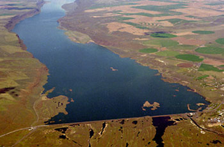
Priest Rapids Dam is a hydroelectric, concrete gravity dam; located on the Columbia River, between the Yakima Firing Range and the Hanford Nuclear Reservation, and bridges Yakima County and Grant County, in the U.S. state of Washington. The dam is 24 miles south of the town of Vantage, and 47 miles northwest of the city of Richland. It is located at mile marker 397.1 from the mouth of the Columbia. It is owned by the Grant County Public Utility District (PUD). Priest Rapids, for which the dam was named, are now submerged beneath the dam's reservoir.

Grand Coulee Dam is a concrete gravity dam on the Columbia River in the U.S. state of Washington, built to produce hydroelectric power and provide irrigation water. Constructed between 1933 and 1942, Grand Coulee originally had two powerhouses. The third powerhouse ("Nat"), completed in 1974 to increase energy production, makes Grand Coulee the largest power station in the United States by nameplate-capacity at 6,809 MW.

The Columbia River drainage basin is the drainage basin of the Columbia River in the Pacific Northwest region of North America. It covers 668,000 km2 or 258,000 sq mi. In common usage, the term often refers to a smaller area, generally the portion of the drainage basin that lies within eastern Washington.

The Columbia Basin Project in Central Washington, United States, is the irrigation network that the Grand Coulee Dam makes possible. It is the largest water reclamation project in the United States, supplying irrigation water to over 670,000 acres (2,700 km2) of the 1,100,000 acres (4,500 km2) large project area, all of which was originally intended to be supplied and is still classified irrigable and open for the possible enlargement of the system. Water pumped from the Columbia River is carried over 331 miles (533 km) of main canals, stored in a number of reservoirs, then fed into 1,339 miles (2,155 km) of lateral irrigation canals, and out into 3,500 miles (5,600 km) of drains and wasteways. The Grand Coulee Dam, powerplant, and various other parts of the CBP are operated by the Bureau of Reclamation. There are three irrigation districts in the project area, which operate additional local facilities.

Celilo Falls was a tribal fishing area on the Columbia River, just east of the Cascade Mountains, on what is today the border between the U.S. states of Oregon and Washington. The name refers to a series of cascades and waterfalls on the river, as well as to the native settlements and trading villages that existed there in various configurations for 15,000 years. Celilo was the oldest continuously inhabited community on the North American continent until 1957, when the falls and nearby settlements were submerged by the construction of The Dalles Dam. In 2019, there were calls by tribal leaders to restore the falls.

State Route 24 (SR 24) is a state highway in the south-central region of Washington, in the United States. It travels 79 miles (127 km) from Yakima to Othello, across a portion of the Columbia Plateau. The highway crosses the Columbia River on the Vernita Bridge, located near the Hanford Site. SR 24 terminates to the west at an interchange with Interstate 82 (I-82) in Yakima and to the east at SR 26 in Othello.

State Route 240 (SR 240) is a state highway in the U.S. state of Washington. It travels diagonally from northwest to southwest within Benton County, serving the Hanford Nuclear Reservation and the Tri-Cities region. The highway begins at a junction with SR 24 and travels around Richland on a limited-access bypass. From there, it briefly overlaps Interstate 182 (I-182) and continues southeast as a freeway along the Columbia River into Kennewick, terminating at an interchange with U.S. Route 395 (US 395). SR 240 is one of the busiest highways in the Tri-Cities region, with a daily average of 76,000 vehicles on a section crossing the Yakima River Delta.

The Naches River is a tributary of the Yakima River in central Washington in the United States. Beginning as the Little Naches River, it is about 75 miles (121 km) long. After the confluence of the Little Naches and Bumping River the name becomes simply the Naches River. The Naches and its tributaries drain a portion of the eastern side of the Cascade Range, east of Mount Rainier and northeast of Mount Adams. In terms of discharge, the Naches River is the largest tributary of the Yakima River.

State Route 243 (SR 243) is a state highway in Grant County, Washington. It travels north–south along the Columbia River for 28 miles (45 km), connecting SR 24 at the Vernita Bridge to SR 26 near Vantage. The highway travels through a predominantly rural and desert area, serving two hydroelectric dams and the communities of Desert Aire, Mattawa, and Beverly.

Camp Columbia or Columbia Camp was a prison labor camp established on the north shore of the Yakima River opening on February 1, 1944 near Horn Rapids. The camp was operated between February 1944 and October 1947 by Federal Bureau of Prisons to provide labor supporting the Hanford Site. The camp was used to house "minimum-custody-type improvable male offenders," who had no more than one year to serve. These were violators of national defense, wartime and military laws. Included were conscientious objectors, violators of rationing and price support laws, those convicted of espionage, sabotage and sedition and those convicted by military courts martial. Aliens who failed to register were also in this category but none of them were sent here because the camp was located on the southern edge of the 670 square miles (1,740 km2) Hanford Site.
Dry Falls Dam is a rockfaced earthfill type dam in the U.S. state of Washington. Located in Grant County near Coulee City, it was built as part of the Bureau of Reclamation's Columbia Basin Project. Water from the Columbia River, impounded by Grand Coulee Dam, is pumped into Grand Coulee, a formerly dry canyon, through the short Feeder Canal. Grand Coulee's north end is sealed by North Dam and Dry Falls Dam stretches across the midsection of the Coulee. This allows the water pumped from the Columbia River to fill the upper Grand Coulee, creating a large equalizing reservoir known as Banks Lake. Water from the reservoir is fed into the irrigation project's Main Canal, which runs south from Dry Falls Dam to another reservoir called Billy Clapp Lake, formed by Pinto Dam.
The Rattlesnake Hills, also known as Rattlesnake Ridge, is a 16-mile (26 km) long anticline mountain ridge in Yakima County and Benton County in the U.S. state of Washington. It should not be confused with the much smaller Rattlesnake Ridge located near the west end of Ahtanum Ridge just south of Yakima, Washington and west of Union Gap, Washington. The highest point in the hills is the 3,629 feet (1,106 m) Lookout Summit, which surpasses the more well-known Rattlesnake Mountain by approximately 100 ft (30 m). The Rattlesnake Hills are part of the Yakima Fold Belt of east-tending long ridges formed by the folding of Miocene Columbia River basalt flows.
Amon Creek is the largest tributary of the Lower Yakima River in Benton County, Washington. From the source of its East Fork to its mouth at the Yakima, it flows about 13 miles (21 km), passing through Kennewick and Richland. The East Fork as well as the main course north of where both forks come together flow south to north. The West Fork starts in Badger Canyon by heading south, but slowly wraps around along with the topography of the canyon to flow out of it northbound. There is an easily visible riparian zone along most of the length of the main course, along with the West Fork up Badger Canyon and the East Fork until I-82.
The following outline is provided as an overview of and topical guide to infrastructure of the U.S. state of Washington.

Locke Island is an island located in the Hanford Reach of the Columbia River in Washington, United States. The island is protected as part of the Hanford Reach National Monument, which was created out of lands surrounding the Hanford Site. The island is an important archeological site and is on the National Register of Historic Places. These cultural resources are being threatened by erosion resulting from a landslide changing the river's course.
