
Hornchurch is a suburban town in East London, England, and part of the London Borough of Havering. It is located 15.2 miles (24.5 km) east-northeast of Charing Cross. It comprises a number of shopping streets and a large residential area. It historically formed a large ancient parish in the county of Essex that became the manor and liberty of Havering. The economic history of Hornchurch is underpinned by a shift away from agriculture to other industries with the growing significance of nearby Romford as a market town and centre of administration. As part of the suburban growth of London in the 20th century, Hornchurch significantly expanded and increased in population, becoming an urban district in 1926 and has formed part of Greater London since 1965. It is the location of Queen's Theatre, Havering Sixth Form College and Havering College of Further and Higher Education.

Romford is a large town in east London and the administrative centre of the London Borough of Havering. It is located 14.1 miles (22.7 km) northeast of Charing Cross and is one of the major metropolitan centres identified in the London Plan. Historically, Romford was a market town in the county of Essex, and formed the administrative centre of the liberty of Havering before that liberty was dissolved in 1892. Good road links to London and the opening of the railway station in 1839 were key to the development of the town. The economic history of Romford is characterised by a shift from agriculture to light industry and then to retail and commerce. As part of the suburban growth of London throughout the 20th century, Romford significantly expanded and increased in population, becoming a municipal borough in 1937 and was incorporated into Greater London in 1965. Today, it is one of the largest commercial, retail, entertainment and leisure districts in London and has a well-developed night-time economy as well. Its population, as of 2011, was 122,854.

The London Borough of Havering in East London, England, forms part of Outer London. It has a population of 259,552 inhabitants; the principal town is Romford, while other communities are Hornchurch, Upminster, Collier Row and Rainham. The borough is mainly suburban, with large areas of protected open space. Romford is a major retail and night time entertainment centre, and to the south the borough extends into the London Riverside redevelopment area of the Thames Gateway. The name Havering is a reference to the Royal Liberty of Havering which occupied the area for several centuries. The local authority is Havering London Borough Council. It is the easternmost London borough.
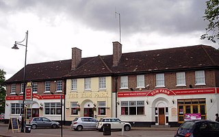
Elm Park is a suburban planned community in East London within the London Borough of Havering. Located 14.3 miles (23.0 km) east-northeast of Charing Cross, it is identified as a district centre in the London Plan with several streets of shops and a priority for regeneration. Prior to the construction of the extensive Elm Park Garden City development in the 1930s it was a scattered settlement of farms in the south of the parish of Hornchurch. Elm Park has been connected to central London by the electrified District line service since 1935 and the planned development of the area formed part of the interwar private housing boom that was interrupted by World War II. After the war Elm Park expanded with social housing and it has formed part of Greater London since 1965.
Dagenham is a town in East London, England, within the London Borough of Barking and Dagenham. Dagenham is centred 11.5 miles (18.5 km) east of Charing Cross.

Barking is a suburb and area in Greater London, within the Borough of Barking and Dagenham. It is 9.3 miles (15 km) east of Charing Cross. The total population of Barking was 59,068 at the 2011 census. In addition to an extensive and fairly low-density residential area, the town centre forms a large retail and commercial district, currently a focus for regeneration. The former industrial lands to the south are being redeveloped as Barking Riverside.
Havering, also known as Havering-atte-Bower, was a royal manor and ancient liberty whose area now forms part of, and gives its name to, the London Borough of Havering in Greater London. The manor was in the possession of the Crown from the 11th to the 19th centuries and was the location of Havering Palace from the 13th to the late 17th century. It occupied the same area as the ancient parish of Hornchurch which was divided into the three chapelries of Havering, Hornchurch and Romford.

East London refers to the part of London, England, east of the ancient City of London and north of the River Thames. It consists of areas in the historic counties of Essex and Middlesex.

The London Riverside is a redevelopment area on the north side of the River Thames in East London, England and part of the larger Thames Gateway redevelopment zone. The London Riverside area forms part of the Green Enterprise District, a project to create a low-carbon economy region in Greater London. Land available for redevelopment is owned by GLA Land and Property. From 2004 to 2013 the redevelopment of London Riverside and the Lower Lea Valley was the responsibility of the London Thames Gateway Development Corporation. There is also a London Riverside business improvement district which covers a smaller area.

Thames Chase is a community forest of 9842 hectares located in 47 sites in London and Essex, England. Its stated aim is "to renew and regenerate the landscape at the edge of East London and South Essex by creating Thames Chase, the Community Forest: a varied wooded landscape for local people to influence, create, use, enjoy and cherish".

Beam Reach is a redevelopment area in London, England and part of the London Riverside section of the Thames Gateway. It is an industrial area adjacent to the new neighbourhood of Beam Park.

Hornchurch was a local government district in southwest Essex from 1926 to 1965, formed as an urban district for the civil parish of Hornchurch. It was greatly expanded in 1934 with the addition of Cranham, Great Warley, Rainham, Upminster and Wennington; and in 1935 by gaining North Ockendon. Hornchurch Urban District Council was based at Langtons House in Hornchurch from 1929. The district formed a suburb of London and with a population peaking at 131,014 in 1961, it was one of the largest districts of its type in England. It now forms the greater part of the London Borough of Havering in Greater London.
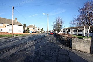
South Hornchurch is a locality to the south of Hornchurch in London Borough of Havering, east London. It is a suburban development situated 13.6 miles (21.8 km) east of Charing Cross. The area is a relatively recent addition, compared with the more mature suburbs in Havering. It was built on open farmland and the former site of RAF Hornchurch.

The River Rom, also known as the River Beam below its confluence with the Ravensbourne, is a tributary of the River Thames in England that flows through east London suburbs surrounding the metropolitan centre of Romford, part of it forming a section of the boundary between the London boroughs of Barking and Dagenham and Havering. The Rom is culverted for a brief midsection as it passes through the centre of Romford.

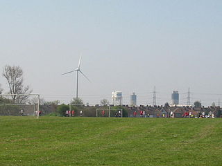
The Dagenham wind turbines are two 85-metre (279 ft) high Enercon E-66 and one E-82 wind turbines located on the Dagenham estate of the Ford Motor Company in East London, England. The first two turbines were completed in April 2004 and the third was installed in 2011. They are landmarks of the skyline and the first wind farm to be built in London.
Beam Park is a new neighbourhood in the south of the London Borough of Barking and Dagenham and the London Borough of Havering. It is named after the River Beam which forms the boundary between the boroughs. It will be served by Beam Park railway station in Havering. 2899 homes are planned, with 2166 in Barking and Dagenham and 733 in Havering. It will include a town centre in the Havering part of the development. It covers an area of 29 hectares. It previously formed part of the Ford Dagenham plant site. The development is a joint venture between London and Quadrant and Countryside Properties. Planning consent was given in September 2018 and construction began in May 2019. It is part of the London Riverside opportunity area and is designated as a housing zone by the Greater London Authority.
The Centre for Engineering and Manufacturing Excellence (CEME) is a not-for-profit education and skills organisation at Rainham, London in the London Borough of Havering.

Rainham is a suburb of East London, England, in the London Borough of Havering. Historically an ancient parish in the county of Essex, Rainham is 13.6 miles (21.9 km) east of Charing Cross and is surrounded by a residential area, which has grown from the historic village, to the north and a commercial area, fronting the River Thames, to the south. As part of the suburban growth of London in the 20th century, Rainham significantly expanded and increased in population, becoming part of Hornchurch Urban District in 1934, and has formed part of Greater London since 1965. The economic history of Rainham is underpinned by a shift from agriculture to industry and manufacture and is now in a period of regeneration, coming within the London Riverside section of the Thames Gateway redevelopment area.
Public transport in the London Borough of Havering, in east London, England, is a mix of National Rail, London Underground, London Overground and Crossrail and London Buses services. Rail services are primarily radial to central London with bus services providing most of the orbital connections. The public transport authority is Transport for London and the local authority is Havering London Borough Council.
Orchard Village, formerly known as the Mardyke Estate, is a housing development in the South Hornchurch area of London, England.


